Covered one side of Johnny Hill Drive between Hefler and Garland Street.
Diary Entries in English
Recent diary entries
Posted by Custom Boxes Uk on 29 July 2025 in English.

Hi OSM Community,
Today I added the location of our custom packaging workspace to the map to help local businesses and delivery services find us more easily. We specialize in producing eco-friendly and custom packaging solutions for food, retail, and cosmetic industries in the UK.
OpenStreetMap has been a great tool for navigating and contributing to local visibility. Mapping our business here also helps others discover nearby services and suppliers more efficiently.
If you’re ever searching for sustainable sandwich boxes, earring packaging, or cardboard containers, we’re here to help — and now easier to find on the map!
Looking forward to making more contributions to the platform soon.
Thanks, Custom Boxes UK
There has been a recent surge of interest in mapping walking infrastructure in Melbourne. This is very exciting because many parts have been lacking for a long time.
I have been adding some things piecemeal over the years. Recently I have made a more concerted effort to get footpath and crossing data into the Map. Several other users have been doing a huge amount to make this happen.
Here I wanted to briefly share a summary of my approach to mapping these footpaths and crossings. As is custom for OSM, this is not prescriptive at all; just a description of how I am approaching this task. It is based on consistency of edits and consistency with existing and new data.
Footpaths
highway=footway
footway=sidewalk
I am also including the surface where known. Most footpaths are built of concrete, especially in older suburbs. The next most common would be asphalt, but there are still some unpaved footpaths - even in built-up areas. I think this is important to include for accessibility and route planning.
surface=concrete
One important aspect here is that I am mapping footpath ways separately to the crossing ways. Which brings us to…
Crossings
highway=crossing
crossing=*
crossing:island=*
crossing:markings=*
Here is an example of a simple T-intersection that shows my general approach to mapping ways for footpaths and crossings separately.
Posted by momiji-takinogawa on 28 July 2025 in English.
In Japan, when you buy tobaccos from a vending machine, you first have to prove that you are 20+ years old. Since 2008, The Japan Tobacconist Federation has been issuing “taspo” smart cards to adult smokers. You can apply these cards to cigarettes vending machines to activate them. Back in 2008, 97% of the vending machines supported taspo for age verification.
Due to technical limitations, taspo system was announced to be shut down in March, 2026, and some vending machines are now retrofitted with new age verification modules that accept a driver’s license card, “My Number Card” (which is officially called Individual Number Card in English), and/or passports (ref: list of government-recognized age verification modules for cigarettes vending machines).
I started to tag taspo-compatible vending machines with authentication:taspo=yes, and those with the other verification methods with authentication:JP:driving_licence=yes, authentication:JP:individual_number_card=yes, or authentication:passport=yes, respectively.
I added another set of buildings on Hamel Street and Garland Street. Had to also fix some naming issues on Hamel Street

A collection/showcase of the different buildings and areas that I have mapped in 3D (through much trial and error). Each location has a link to view on OSM where you can see what building parts and tagging I’ve used to represent these buildings. The heights I have tagged on building parts are mainly calculated by working out the ratio of a building’s height and width in a photo (I used paint.net to measure these dimensions in pixels) and applying this to the width that can be measured from aerial imagery.
Rue de la Providence, Charleroi 🇧🇪
Mapped 23rd July 2025 - location on osm.org / location on F4map
 A heavily graffitied derelict industrial building on brownfield land outside Charleroi
Parry Place, London 🇬🇧
I added several more houses sheds and garages to the Happy Valley Goose Bay area. I think that i will try to add more to other areas shortly, and speed up my time to a street a day so that I can start on other communities sooner.
Recently Malaga’s bus route number 37 was extended to Residencia Santa Clara in the hills outside the city. This part of the route had been suspended for a few years, and I knew that some stops had been relocated in the meantime. So I took the bus to the last stop to update the mapping in OpenStreetMap.
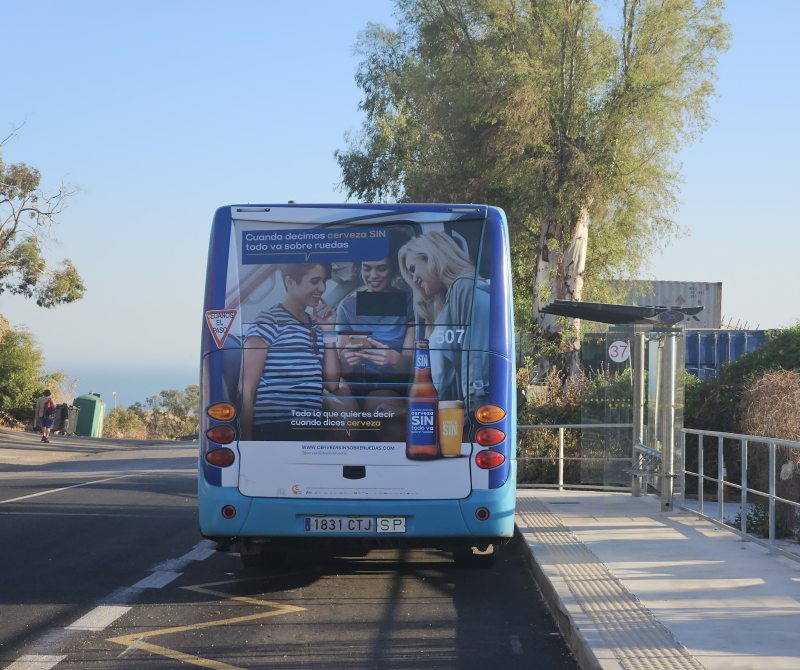
As I walked back towards the city down a steeply sloping road (pausing to tag it as sidewalk=no), I wondered if I had just visited the city’s highest bus stop. I could probably have confirmed this fairly quickly with the help of a relief map - there were only a few realistic candidates.
But I happened to be looking at the OSMnx Python package for unrelated reasons. And I had already downloaded Digital Terrain Model files covering the city of Malaga. Obviously destiny wanted me to take a library intended for analysing important questions about urban road networks, and use it to devise an over-engineered answer to my trivial question about bus stops.
Newark Fence Co is a townhouse complex in Rosenberger Dr, Middletown, DE 19709
Completed
💕 osm.org/relation/1155266/history/177
💕 https://osm.mapki.com/history/relation/1155266#version-1
AlhamdullilahirRabil’aalaameen
27 July 2025 at 09:30