Adam Franco's Comments
| Changeset | When | Comment |
|---|---|---|
| 118614825 | over 3 years ago | See note in osm.org/changeset/118614405 . This is properly a place=town regardless of the absolute population. |
| 118614405 | over 3 years ago | @Fred, I'm not local to West Virginia so I can't speak to these communities specifically, but I noticed you making similar changes all over the US. That wiki page you are referencing says that these are "some rough rules of thumb to have emerged in the US are". It is most definitely *not* a rule that all towns must have at least 10,000 population. Please pause on these mass changes and discuss further in the [talk-us] mailing list or the OSM-US Slack https://slack.openstreetmap.us/ before blanket-changing the place levels just based on population. While those population numbers are guidelines, they aren't rules. The presence of other amenities and community services is a better indicator of Town versus Village distinction than a raw population number. Municipalities with hospitals, several groceries stores, many shops and restaurants, car dealerships, movie theaters, and light or heavy industry are properly place=town even if their population is less than 10,000. |
| 74058778 | over 3 years ago | No problem, thanks for taking a look! |
| 118338350 | over 3 years ago | Yeah, the ACC made the process SO much simpler in NY than other states. Unfortunately ACC=4 and below are much more hit-and-miss in terms of network connectivity. There's still an open question in the community if ACC can be trusted around NYC. I personally think we can still trust the ACC, but some folks feel that some urban expressways should remain trunk. I'm not local to NYC, so don't really have as much understanding of its road network compared to upstate. Much of the discussion is happening in the #highway-classification, #local-nyc, and #local-newyorkstate channels of the OSM-US Slack: https://slack.openstreetmap.us/ Here's more info on the overall US Highway Classification project if you haven't stumbled onto it yet:
Lastly, if you haven't see the new [work-in-progress] Americana style, check out the expressway rendering around Albany: https://zelonewolf.github.io/openstreetmap-americana/#10.64/42.7219/-73.9146 The data is a couple of months stale at this point so the Binghamton changes won't be reflected yet, but this new style is now rendering trunk, primary, secondary, and tertiary expressways distinct from non-expressways. Don't hesitate to reach out either on Slack or through my profile if questions come up about the Highway Classification project in general or specific. No one has picked up the banner for NJ (or PA) yet and collaborators are certainly needed. :-) |
| 74058778 | over 3 years ago | Is this the page in the wiki? osm.wiki/National_Register_of_Historic_Places
From my reading of those the boundary=protected_area only gets applied if it is a larger site and not a single building. It might be worth updating your hotkeys to have a different one for buildings and sign-posts from historic districts/etc. :-) |
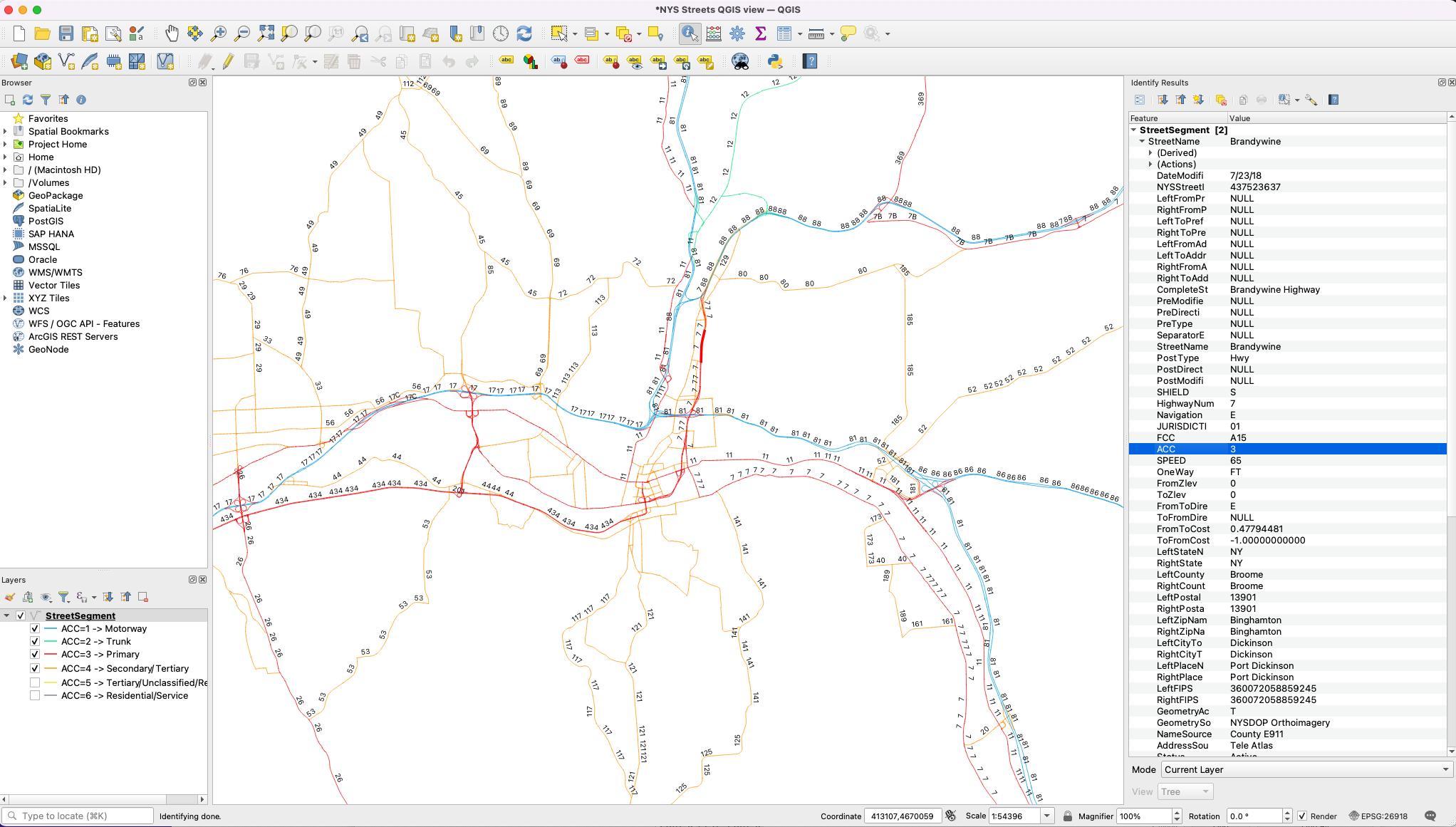
| 118338350 | over 3 years ago | I missed your note about the Brandywine Highway, I'm seeing that listed as an ACC=3 as well. Here's a zoomed-out screen-shot of NYS Streets around Binghamton:
|
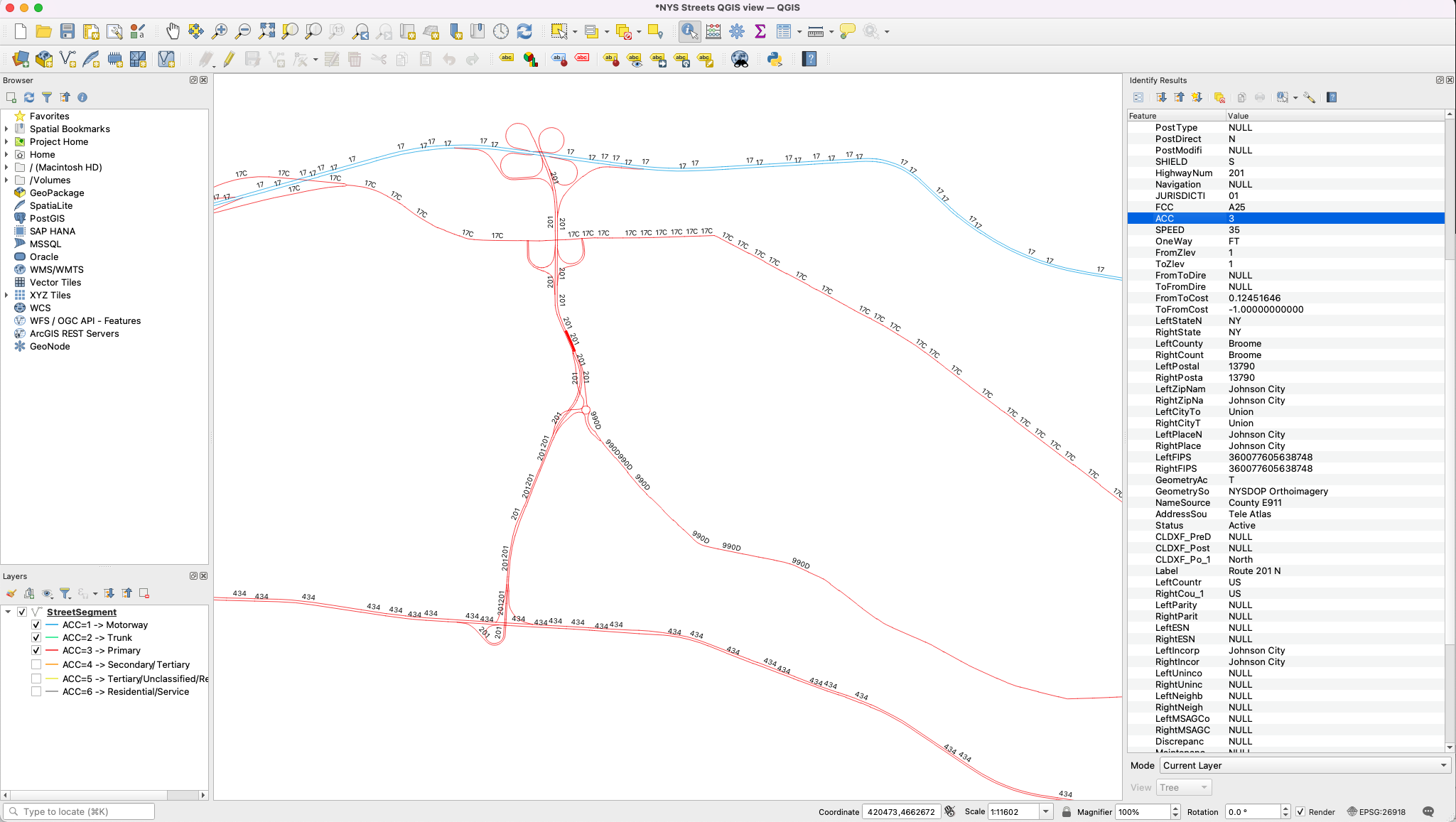
| 118338350 | over 3 years ago | Thanks for the note, ScantLeopard336! An ACC=2 *would* make the road trunk according to the current guidelines. I downloaded NYS Streets last week from
Here's a screen-shot of what I'm seeing:
Given that the southern end of NY-201 only connects to other ACC=3/primary roads for local connections (rather than inter-city connections), ACC=3/primary seems consistent to me, but I'd be happy to see it updated if there is new data. |
| 117064005 | over 3 years ago | It turns out that it wasn't too hard to manually revert the classification while leaving the rest of your changes in place, so no need for further action. Please do reach out if you have any questions about highway classification as this is an ongoing project around the country. I see you're doing a lot of editing around upstate NY. Lots of other mappers in the area are collaborating on highway classification and other mapping topics in the OSM-US Slack at https://slack.openstreetmap.us/ . Join us in the #local-newyorkstate and #highway-classification channels if you're interested. Best,
|
| 117064029 | over 3 years ago | See comments on osm.org/changeset/117064005 With the new 2021 US Highway classification project highway=trunk is no longer used to indicate "expressway" construction. Use expressway=yes for this. Please revert this segment back to highway=primary. |
| 117064005 | over 3 years ago | Hi barndny, what is your reasoning for upgrading the LOSP to motorway? As described in
NY's Arterial Classification Code (ACC) is a connectivity-based code that is being used to categorize highways in NY. Could you please reclassify back to highway=primary + expressway=yes? I'd rather not do a full revert and lose all of your bridge changes. |
| 74058778 | over 3 years ago | Hi Korgi1, this changeset add boundary=protected_area to a building. While the other tags seem normal, adding boundary=protected_area to buildings isn't something I've encountered before. Can you provide a reference as to why you are adding that boundary tag? osm.wiki/Tag:boundary%3Dprotected_area doesn't mention any use on buildings or other objects. A built itself isn't really a boundary, though I appreciate that the building itself is protected. |
| 114983290 | over 3 years ago | Hi Himké, let us us know if you have any questions on the 2021 US Highway Classification project. The OSM-US Slack is where most of the discussion is happening, but many of us also subscribe to the [talk-us] mailing list. :-) |
| 115398558 | over 3 years ago | Additional note: See osm.wiki/Proposal:_New_York/Highway_Classification for the new NY guidelines and osm.wiki/United_States/2021_Highway_Classification_Guidance for the overall project. |
| 115398019 | over 3 years ago | Additional note: See osm.wiki/Proposal:_New_York/Highway_Classification for the new NY guidelines and osm.wiki/United_States/2021_Highway_Classification_Guidance for the overall project. |
| 114507515 | over 3 years ago | See the comments on your other changeset at osm.org/changeset/114507228. The NY DOT has given this section of roadway ACC=3 (which makes it highway=primary) because it just provides a local/suburban connection rather through connectivity to other major cities.
|
| 115397860 | over 3 years ago | Additional note: See osm.wiki/Proposal:_New_York/Highway_Classification for the new NY guidelines and osm.wiki/United_States/2021_Highway_Classification_Guidance for the overall project. |
| 114833060 | over 3 years ago | See the comments on your other changeset at osm.org/changeset/114507228. The NY DOT has given this section of roadway ACC=3 (which makes it highway=primary) because it just provides a local connection to downtown Albany and not through connectivity to other cities. |
| 114864287 | over 3 years ago | See the comments on your other changeset at osm.org/changeset/114507228. The NY DOT has given this section of roadway ACC=3 (which makes it highway=primary) because it just provides a local connection to downtown Albany and not through connectivity to other cities. |
| 114983290 | over 3 years ago | Hi Himké, For NY highway classifications, we're now using the state's Arterial Classification Code (ACC) to determine which highway=* value to use. The State DOT developed the ACC to inform routing importance (rather than physical structure of a road), which maps directly to the new process for categorizing highways that we're moving to in the US. highway=trunk no longer means "expressway" but rather now is being used for the the most important long-distance routes so that US mapping practice matches how highway=trunk is used in the rest of the world. The NY DOT has determined that this section of the Lake Ontario State Parkway has ACC=3 due to it being a local connector rather than a long-distance regional connector. This maps to highway=primary+expressway=yes in OSM. See osm.wiki/Proposal:_New_York/Highway_Classification for the new NY guidelines and osm.wiki/United_States/2021_Highway_Classification_Guidance for the overall project. A large community of mappers are working on highway classification and discussing in the OSMUS Slack's #local-newyorkstate and #highway-classification channels: https://osmus-slack.herokuapp.com/ . It would be great for you to join us to discuss there before undoing these changes. |
| 114507228 | over 3 years ago | Hi Himké, For NY highway classifications, we're now using the state's Arterial Classification Code (ACC) to determine which highway=* value to use. The State DOT developed the ACC to inform routing importance (rather than physical structure of a road), which maps directly to the new process for categorizing highways that we're moving to in the US. highway=trunk no longer means "expressway" but rather now is being used for the the most important long-distance routes so that US mapping practice matches how highway=trunk is used in the rest of the world. The NY DOT has determined that this section of the LaSalle Expressway has ACC=3 due to it being a local connector rather than a regional connector. This maps to highway=primary+expressway=yes in OSM. See osm.wiki/Proposal:_New_York/Highway_Classification for the new NY guidelines and osm.wiki/United_States/2021_Highway_Classification_Guidance for the overall project. A large community of mappers are working on highway classification and discussing in the OSMUS Slack's #local-newyorkstate and #highway-classification channels: https://osmus-slack.herokuapp.com/ . It would be great for you to join us to discuss there before undoing these changes. |