OpenStreetMap logo OpenStreetMap

AndiG88's Diary

Recent diary entries

After reading a diary entry about noexit=* Tags a few days ago I check out my area and…

Alt text

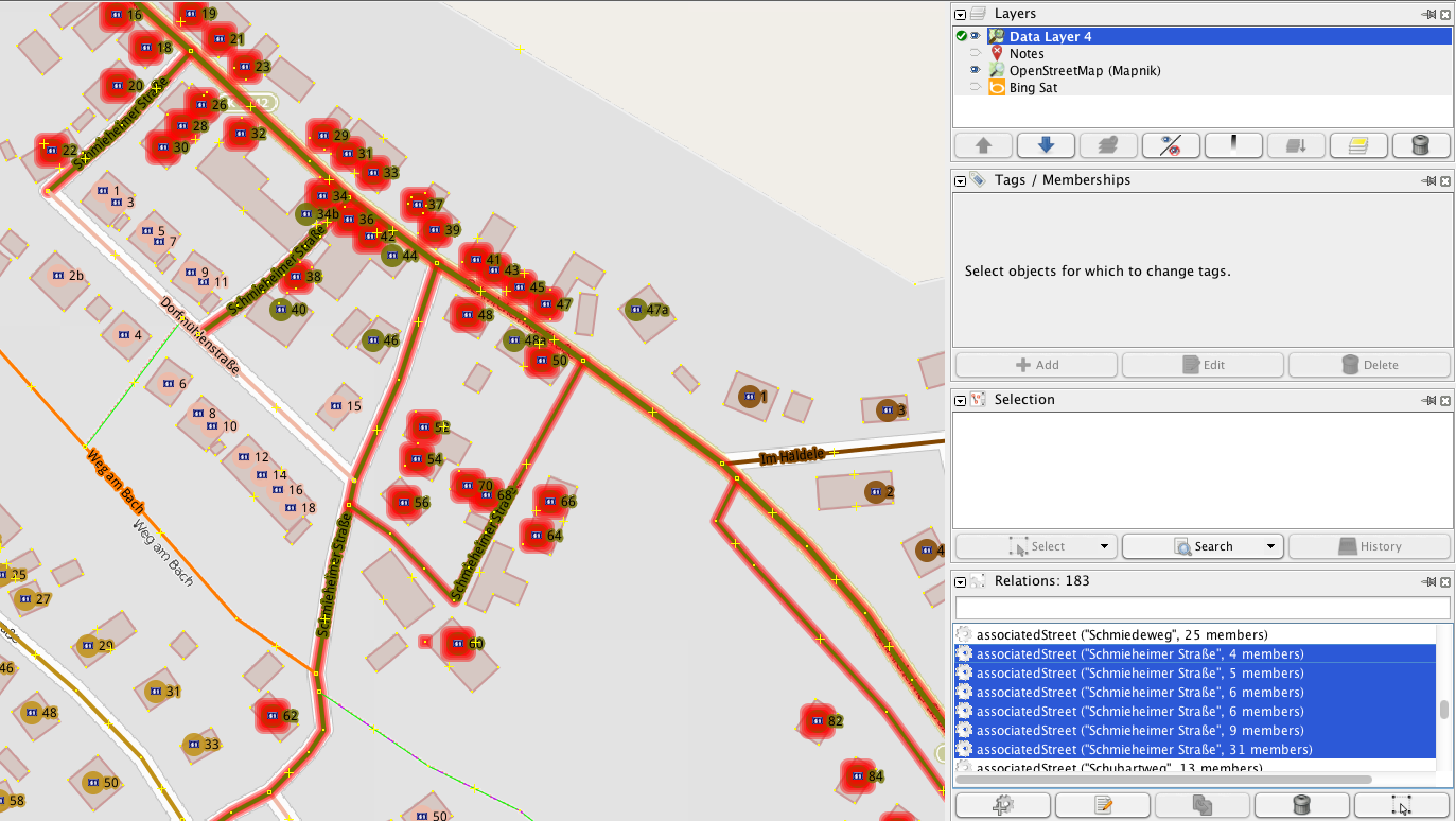
I started to clean up my area using Osmose (which recently became available in Germany and really is an awesome QA tool!) and it’s slowly getting better - have to wait for Osmose to update what I already fixed.

Many people seem to put it on ways, which is bad for routing as I found out when fixing some stuff for leitstellenspiel.de. Many tags also just seem to be very old and somehow just ended up in the wrong places by splitting streets and others are there even thought there is a foot way at the end of the road.


Use the noexit=yes tag only on the very last node Node at the end of a highway=* or on the last way Way to indicate when doubtful that the impossibility to travel further by any transport mode is perfectly normal, due to otherwise existing road layout. * osm.wiki/Key:noexit


Fix the issues in your areas with Osmose!

Stumbled over this in the current Episode…

Screenshot Cobra11 RTL NOW

Staffel 25: Auf eigene Gefahr (Source)

Wikipedia: Alarm für Cobra 11 – Die Autobahnpolizei

Location: Quartier Saint-Jacques - Sint-Jacobswijk, Quartier du Centre - Centrumwijk, Pentagon, Brussels, Brussels-Capital, 1000, Belgium

I have been trying to document all the common tags for keys like amenity, shop, craft etc. in the Wiki using TagInfo. In the process I found several low usage tags that might have other matching well established tags. I put a small section with a Taginfo box and Overpass API link on those pages allowing mappers to find these tags in their area to fix them with local knowledge as some Tags might indeed be valid. Now I also added a category to them to make it easier to find all such tags in one’s area!

Example how it looks on the page: Alt text

Would be great if everybody could take a look in his/her region and maybe clean up some outdated tags!

A comment on the disussion page is often not enough.

After spending a lot of time in the Wiki recently it was really surprising to see how many errors there are when it comes to spelling and to using British English even on well established tags. And some of then are just REALLY obvious like vending=news_papers, which comes from this proposal 8 years ago and just one person pointed it out.

The reason I post this is because I just saw the other diary entry about sport=beachvolleyball…Those errors are more common than people think and become more difficult to fix for every day that goes by.

British English

Even more important if you notice that AE was used, because a lot less people will realize that. For example shop=jewelry is AE and while pointed out on the page itself as well as the talk page nothing happened. What makes it even better is that craft=jeweller is mentioned twice on the same page.

See Also

In some way this is also a follow up to my last diary entry: Please create Wiki entries for Tags!, because for example as pointed out translation errors can become a lot more obvious if you put a image next to them or just looking for an image you might notice the spelling is wrong.

PS: Obviously everybody should act when realizing a tag is wrong, but many errors will probably not be noticed on the spot by non-native speakers, especially AE vs. BE.

Please create Wiki entries for Tags!

Posted by AndiG88 on 11 July 2014 in English.

I have been spending some time in the Wiki recently cleaning up a lot of tags, mostly emergency= and vending=. The one thing I noticed over and over again was that the lack of a initial tag page often causes problems that could have been easily avoided (Translation errors, different understandings how to use a tag or even definitions on different wiki pages). It also allows you to link to similar tags (or be liked to), proposals, wikiepdia pages etc. which helps a lot.

Creating a new page

There are a lot of different ways, the easiest is probably that you just klick on a tag red link. Another option is to open a similar tag and just change the URL or just replace it here osm.wiki/Tag:KEY=VALUE and hit enter.

Always use the Template

99.99% of the time you need the first one. Just copy the whole first column from the grey table into the empty wiki page you created. Now you should at least always add key= & value= One of the main benefits of the template is that it includes the language bar. It’s also from where taginfo gets its description.

DO NOT DELETE ANY LINES YOU LEFT EMPTY! It does not have any negative impact. There is nothing more annoying than wanting to improve a page later and you have to go to the template and find the parameter.

Images

Add images, especially in the template. Especially with all the translation errors this can go a long way.

Upload file: osm.wiki/Special:Upload

But you can also link to any file from wiki commons (commons.wikimedia.org). Best way to find images is with google:

https://www.google.com/search?hl=en&site=imghp&tbm=isch&source=hp&q=SEARCHTERM+site:commons.wikimedia.org

Found nothing? You can always look on Flicker or other websites for images licensed under CC. There is also a Uploader for Wiki Commons which checks the license and creates the attribution for you.

Weekly OpenStreetMap Task

Posted by AndiG88 on 2 July 2014 in English.

The German OSM Blog just kicked off its 2nd weekly task (Wochenaufgabe). The goal is to encourage mappers to tag a certain POIs during that period.

The first task was to tag bicycle tube vending machines. Over the next two weeks (community wanted a bit more time) we want to improve the coverage of electric charging stations.

In created a Wiki page to keep track of the tasks and make it easier for non-German mappers to take part:

osm.wiki/Wochenaufgabe

WikiProject Emergency Cleanup

Posted by AndiG88 on 8 June 2014 in English.

aims to structure tags and pages associated with Emergency, especially emergency=*.

Emegency Cleanup

osm.wiki/WikiProject_Emergency_Cleanup

Some might already have seen this banner on a few Wiki pages recently as one of the first steps to start the project was trying to find all pages related to this topic. I saw the need for it when osm Hydrant was released I realized the Wiki was pretty confusing on this topic and also had a lot of pages that only existed in German.

Some goals I came up with so far:

  • Gather relevant Wiki entries related to Emergency

  • What is missing?

  • Develop a new structure (Templates, emergency/amenity, “Emergency” Wiki page)

  • General Cleanup

This is of course not complete and it would be great if more people would join the Discussion and help with the Wiki page.

See full entry

ResetTheNet

How you participate is up to you, but be ambitious! Sites: promise to add HTTPS, HSTS, and PFS this year.

OpenStreetMap Enhances User Privacy

Today, OpenStreetMap has enabled encryption (SSL) to all of the openstreetmap.org website, thereby enhancing the privacy of its users.

You can now browse the site at osm.org (note the ‘https’). This means your browsing activity is secure from snooping.

https://blog.openstreetmap.org/2014/02/11/osm-enhances-user-privacy/


I just stumbled over a article about this and thought this might be something for OpenStreetMap, considering it also endorsed the “Day We Fight Back” campaign.

As this was on pretty short notice I though I’d just write this diary. I wasn’t really sure who to contact about adding the OSM website or if that should be done at all. I guess it is up to the OpenStreetMap Foundation?

Regio OSM Straßenlistenauswertung - Jeder kann mitmachen!

Posted by AndiG88 on 5 April 2014 in German (Deutsch). Last updated on 8 April 2014.

Ich habe mich in letzter Zeit immer wieder durch diverse Gemeinden Bayerns gekämpft und stelle fest, dass ich immer wieder auf die gleichen einfachen, oft ohne Ortskentinsse verbesserbaren Fehler stoße, insbesonere wenn die Abdeckung <90% liegt. Deswegen fasse ich diese jetzt einmal nach einer mini Einführung als kleine Motivation zusammen, vielleicht trauen sich dann mehr Leute dran.

Alt text

Was ist die Straßenlistenauswertung?

Dort werden Straßenlisten, die von OSM Community Mitgliedern bei den Städten und Gemeinden angefragt wurden, mit den in OpenStreetMap vorhandenen Straßen abgeglichen. Dies ermöglicht es einem Fehlende Staßen zu finden.

Das abarbeiten der einfachen Fehler ist meiner Meinung zudem wichtig, da sich Mapper mit Ortskenntnissen gleich den komplizierteren Fällen widem können.

Warum ist das wichtig?

See full entry

highway=bus_stop - Mappen für den Renderer

Posted by AndiG88 on 29 March 2014 in English. Last updated on 30 March 2014.

If #OpenStreetMap had an award for the most used tag for the sole purpose that something shows up on the map, highway=bus_stop would be a promising contender. The headline a common phrase in the German OSM community says just that: Mapping for the render engine.

I’ve been mapping for 3 months now and after finishing all the house numbers in my village POIs and Bus stops where next on my list and I had never been more confused.

highway=bus_stop is widely used to mark the position where passengers await for a bus service […] however there is not complete agreement within the community on this matter, and some users advocate using highway=bus_stop as a node within the highway=* at the place where the vehicle stops.

Great so what now? A 3rd opinion? What about the German Wiki entry:

This use is incompatible with the new public transport schema and should be avoided.

Are you fucking kidding me.

See full entry

Médecins Sans Frontières (MSF) Switzerland rapidly needs maps of three towns in order to support their relief efforts of an ebola-like outbreak in Guinea. MSF are requesting assistance from HOT as this area is currently unmapped.

Hot Logo

http://hot.openstreetmap.org/updates/2014-03-26_mapping_guinea_help_wanted


Just wanted to share this here as I guess more people check this blog than the hot.openstreetmap.org homepage.

Location: Gnoumoulou, Gueckedou Centre, Guéckédou Prefecture, Nzérékoré Region, Guinea

I have been reading several User Diaries from the students and looked at their edits. I think this is awesome and wish I had it at my University, but one thing I noticed is that many use the name= key wrong and I guess this is the best way to reach most of you.

Name is the name only

The names should be restricted to the name of the item in question only and should not include categories, types, descriptions, addresses or notes. If something really doesn’t have a name, don’t add one to OpenStreetMap. Any additional information should be included in separate tags (see e.g. aforementioned links) to identify its meaning. osm.wiki/Names

If you name something bin (name=bin) or ramp (name=ramp) no software will recognize it correctly and all the effort you put into locating and mapping the way or POI was in vain.

Map Features

Can we please fix the SEO Blacklink Spam?

BlackHat SEO

I have been mapping here for a few weeks now and what caught my eye from day one was the pretty large amount of spam here and how long it sometimes takes until it gets removed - IF it gets removed at all…

And while diary entries usually get removed pretty quickly (which is still annoying as they show up in the RSS feeds and on Social Media), some accounts with spam in the user descriptions are over 1 year old as I just found after reading this entry.

So What’s the Solution?

User Descriptions:

  • Someone has to work his way trough the list in the Wiki and remove the profiles.

  • Maybe implement a report Button

User Diaries:

  • Only publish them after a moderator has approved them.

  • Require accounts to have a certain age or amount of edits (the 2nd one could obviously backfire as it might lead to vandalism)


See full entry