OpenStreetMap logo OpenStreetMap

Anton Khorev's Diary

Recent diary entries

OSM link previews

Posted by Anton Khorev on 30 July 2025 in English. Last updated on 4 August 2025.

Some websites allow users to post content with links to other sites and have previews for these links displayed alongside with the posts. Those are typically social media sites, and we’ll refer to them as “social media” in this diary entry. Examples of such sites include: - forums based on Discourse, particularly OpenStreetMap Community Forum - microblogging platforms based on Mastodon, particularly en.osm.town

There are many more of course, with some more widely known examples, such as Facebook and Twitter. We’re primarily interested in the listed above because they are directly related to OpenStreetMap.

A preview usually includes a page title followed by a longer description and an image. Typically when a submitter makes a post with a link, the social media site runs a bot to download the linked web page and scan it for metadata. The metadata usually includes textual attributes and links to preview images. The bot then downloads the images and assembles the final preview to be shown to other users.

Metadata

Here we’re interested in previews of pages on the OpenStreetMap website. Usually the links someone posts are to pages of map locations, editable osm elements (nodes, ways and relations), changesets and diary entries. All of those pages include metadata in one of the formats suitable to generate previews, The Open Graph protocol. The Open Graph metadata consists of several <meta> html elements inside the web page <head>.

The degree to which metadata on OpenStreetMap website pages allows generation of a useful previews however varies. Metadata on diary pages is usually sufficient to build reasonable previews. As an example, we can look at the html source of this diary entry:
See full entry

iD on a phone

Posted by Anton Khorev on 20 April 2023 in English.

Normally the edit button on the osm website is hidden on phones. That’s because you probably don’t have any remote-control-capable editor installed and iD is unusable on small screens. What you’re supposed to do instead is open the Share tool and tap the Geo URI link. This will let you launch any app that understands Geo URIs such as Vespucci.

But to my surprise I was able to use iD on a phone. My note viewer has a tool to open iD on the current map location. It should work similarly to the Edit button except it won’t disappear if the screen is too small. Actually it is hidden by default because too many tools would clutter small screens. But you can always add it back by pressing the ⚙️ button.

When I opened the link, I noticed that iD looks differently compared to what you usually get on a phone. I expected to get that oversized sidebar covering most of the screen. Instead I got everything scaled down to fit on the screen. That happened not because of any changes in iD but because note-viewer opens iD differently.

See full entry

In case you wanted to use my note viewer with another openstreetmap-website-based project - now you can. Although most likely you didn’t because there aren’t many of them and they don’t use notes actively. Additional projects that note-viewer is already configured to work with are:

It’s not a surprise that notes aren’t heavily used in these projects. Often you place a note where the map diverges from reality and you can’t edit the map at the moment. But neither OpenHistoricalMap nor OpenGeofiction represent something that is currently real. Right now OpenGeofiction has less than 100 notes, and it’s not obvious if that project even needs notes. Maybe they might use notes to coordinate editing of their collaborative territories?

Now you can also edit the loaded and selected notes by commenting, closing or reopening them. This might be useful to deal with several notes at once. Actually it was one of the original plans for note-viewer. The situations where it’s helpful include someone modifying a lot of notes without a good reason. For example, users sometimes close existing notes without making any map modifications or providing reasons why the notes are irrelevant. They may do this because open notes look wrong (red with x marks) and closed notes look right (green with ticks). Closing a note may look like confirming it. Probably that’s why users sometimes close even their own notes without making any edits. Now it’s possible to quickly deal with such note modifications by searching for a given username, followed by filtering for user’s close actions, selecting all filtered notes and reopening them.

See full entry

In my last diary entry I wrote about putting the requested note ids into url. I said that it’s likely not going to be a problem because ids are stored in the url part that’s not sent over HTTP therefore it doesn’t matter how long is this part, how many ids it contains. That was said about a typical output of neis-one.org note feeds for countries that contain updates dating back up to a week. For a busy country that’s usually a few hundred notes. Concatenated with single-character separators they result in a few thousand character string appended to a url.

Feeds are not the only way to get note ids from neis-one.org. In fact you may no even want to get notes from the feeds because of their one week age limit. There are regular html pages for each country too, one for all notes, another for open notes. They likely contain more notes than the feeds do. The open notes pages, which are of interest to someone who wants to resolve notes in a given country, can have up to ten thousand notes. I added options to open those with note-viewer, along with arbitrary html files. The last two options in the neis-one.org Get … notes for this country dropdown of the XML tab set up the selector (cells in second columns of tables from neis-one.org webpages) and open the webpage that you have to save to a file and then open that file with note-viewer. Unlike the xml feeds, even Firefox won’t start the download automatically.

See full entry

Notes of countries

One of possible uses of note-viewer is browsing notes in some area. You can do this using the BBox dialog that lets you get notes in a rectangular area. This is similar to how the note layer on the OSM website work and how the editors like JOSM load notes. And it similarly won’t work if the area is too large or not rectangular. So if you want to get notes in a country, you won’t be able to get them easily. But you may know that there are services that show notes for a given country, like the one by Pascal Neis. There you can select a country and get a list of notes filtered by their status.

That’s how you can get a list of notes for a country. But what if you want to see notes on a map? The list doesn’t contain note coordinates so it can’t be done directly. The situation is similar to looking at a list of user’s notes on the OSM website, something that note-viewer was originally written to take care of. Can it handle country lists now? Actually it can handle any list with note ids. In addition to showing webpages with note lists, Pascal Neis’ site also has Atom feeds. It’s going to be easier for us to get note ids from these feeds. And no, unfortunately, they still don’t contain coordinates.

Any list in our case is an XML file, and note-viewer handling it means that it’s possible to come up with selectors for XML elements that contain note ids. If ids are inside some attributes, the names of the attributes also need to be specified. Click on the XML tab in note-viewer and look below the instructions for neis-one.org to see the inputs for selectors and attributes. You won’t have to use them if you only want to get note lists from neis-one.org, just follow the instructions above.

Getting the list

See full entry

One of the things that note-viewer does is showing notes on a map. They are displayed as markers which we can click to find notes in the table. Map markers show us locations and statuses of notes, the rest of note details can be found in the table. But we can dig deeper into these details. From the last diary entry we know that note-viewer looks for links to osm elements inside note comments. When clicked these links display their linked element on the map. That shows us the element geometry, but now we may want to see more details about the element. The map is displayed using Leaflet library1 which supports adding popups to various items that are shown over the base layer. A popup seems like an appropriate place to show the element version, changeset, last editing user and tags.

What’s the best way for us to implement these popups? If we just bind the popup (layer.bindPopup()) to the element geometry on the map, the user would have to click the element for the popup to show up. Sometimes that’s not very convenient to do because of note markers covering the geometry. To make things easier we can open the popup right away (layer.openPopup()) when the element link is clicked. But that’s not the only thing that needs to happen at that moment, and we may find ourselves struggling a bit with Leaflet. Obviously the linked element may be outside the current map view and we need to pan and zoom to it (map.panTo(), map.flyTo() or others). Opening the popup could have done part of this job because by default the map pans to the opened popup. That still doesn’t take care of zooming. But you may think so what, just let the user zoom to the tip of the popup to find the element on the map.

See full entry

One of my goals when developing note-viewer is to try various experimental features. Note-viewer started as a replacement for user’s notes pages. I could have tried changing it in the osm website code but then I’d be constrained by other things. And I want to do some things that are definitely not going to be on the osm website, maybe for a good reason because some of them will turn out to be useless and I’ll throw them away later. In fact, I’ve already thrown away some. If you were using note-viewer before did you notice that round note status icons in the table used to work as radio buttons? They don’t anymore, that was a way to select the date, now you just click the date. What does this date selection do is another topic which we won’t go into here.

What we are going to look into is getting links to various things mentioned in note comments. Actually when the API returns note information it sends note comments in two formats: plaintext and html. However we won’t rely on this html output because users commenting notes enter plaintext and don’t set any links themselves and in the html output everything that looks like a url gets a link, no matter how dubious the site is. We only want links to sites we trust. Obviously one of them is openstreetmap.org. Another one is StreetComplete’s image hosting. Currently that’s all what note-viewer handles, but other sites may get added in the future.

See full entry

Remote control for iD

Posted by Anton Khorev on 24 April 2022 in English.

As you remember from my last diary entry, I tried to make note-viewer communicate with editors. It was relatively easy to do with JOSM because JOSM supports remote control. If I want to open a bunch of notes in JOSM, I can make a remote control call for each note to open its url which JOSM understands. But with iD I had to concede a defeat. The easiest way to open selected notes in iD seems to be exporting the notes to a GPX file and opening it as a custom data layer.

map parameter

But since then you may have noticed that iD has appeared in note-viewer’s toolbar. That means I had a rematch with iD and although I didn’t win it either I got at least something. That something is opening a given map location in iD without losing the edits. That doesn’t seems like much and last time we could open iD at the coordinates we wanted. The difference is that now we can tell the already running iD instance to go there. If we look at the location bar while panning the map in iD we’ll see that map in the hash part is being updated with current coordinates. That’s not surprising, map is one of the documented parameters, we can open iD with map set to the place we need and iD will zoom there. But can we update the location ourselves while iD is running? We may try to edit it right in the location bar. For example, the first number of map value is zoom. Let’s change it and press enter. Nothing seems to happen…

See full entry

Note Viewer and editors

Posted by Anton Khorev on 13 April 2022 in English.

Looks like my diary here is going to turn into a development blog for my note viewer, which I’m going to call note-viewer in this post. I haven’t came up with a fancier name because I wasn’t sure what this thing was supposed to do other than being an alternative to user’s notes pages. Now I’m adding features that are not strictly for viewing notes. After all, you don’t want to just view notes, you want to do something about them.

Editing the notes along with the data

One of the things that you can’t currently do from my note viewer is to manipulate notes, that is you can’t comment or close them. You have to do those things either on osm note pages or in editors. What you can do is to go to a note page by clicking its id in the table, then you can do anything with the note that the osm website permits. It may not be very convenient though because you have to work with that note in isolation, without seeing related notes and other osm data. This lack of note editing functionality is there because I wanted first to implement a replacement for user’s notes pages. You can’t edit notes from those pages either.

But of course you want to edit the notes, usually along with related data. A note may tell about an error in the data, you edit the data, then you close the note. After that you move to another related note. Related notes are the ones you selected with note-viewer based on some criteria. That could be your own notes for some period of time made about some kind of objects. An example of such kind of use is described in my earlier diary entry. Another kind of note manipulation would be mass commenting/closing/reopening of selected notes, but the tool is not yet ready for that and we won’t look at this usage here.

See full entry

Note Viewer update

Posted by Anton Khorev on 30 March 2022 in English.

I’ve fixed some of the limitations of my note viewer that were discussed at the end of this diary post.

  1. Now you can use this tool as a more general interface to /api/0.6/notes/search OSM API requests. Providing a username is no longer required, and it’s possible to do comment text searches and limit the results to date ranges.
  2. Search queries are encoded in URLs. That opens some additional possibilities.
  3. Earlier you could accidentally load too much data that would slow down your browser too much. There weren’t an obvious way out of this situation because the tool always tried to restore the results of the last request. Now it shouldn’t be a problem - just open the page without the query in the URL (without everything after #). Or press the (x) button on the top.
  4. You can open several different requests in different windows at the same time. There’s still one problem left: opening the same request in different windows is not guaranteed to work.
  5. Since queries are stored in URLs you can share links to them. Also you can generate links without typing stuff into the search form. For example, you can use OSM Smart Menu browser plugin to switch to user’s notes as shown by this tool from any webpage that the plugin associates with the user. You need to add this URL template in OSM Smart Menu settings: https://antonkhorev.github.io/osm-note-viewer/#mode=search&display_name={osm_user_name}

Раз уж мне пришлось в двух предыдущих записях обратиться к теме заметок, я выложу из черновиков ещё одну запись на эту тему. Она станет внеочередной записью из серии про OsmAnd и недвухэтапный ввод POI, и речь в ней пойдёт об одной из разновидностей заметок, которые я оставляю из OsmAnd при таком вводе.

Заметки из OsmAnd оставлять приходится, потому что не всё, что нужно проделать с осмовскими данными, возможно или целесообразно пытаться сделать из самого OsmAnd. Необходимые действия можно отложить, оставив в качестве напоминания заметку, в которой описаны либо сами действия, либо наблюдаемая ситуация на местности, если действия ещё не определены или их долго описывать. Именно из-за последнего варианта я и пишу эту запись, так как на заметки могут среагировать другие участники, не зная, что именно по моему мнению надо сделать.

Рассматриваемая здесь разновидность заметок ставится мной на месте отмеченной POI, и содержит следующее утверждение: POI на этом месте не видно, и непонятно, где бы она могла быть. То есть, тут не просто не наблюдается отмеченного на карте заведения, но и само место выглядит для него неподходящим. Если отмеченного заведения не видно, часто это означает, что оно закрылось и, возможно, на его месте открылось другое. Но там, где я ставлю рассматриваемую заметку, я подозреваю, что заведения никогда и не было.

Неподходящее место

Что такое неподходящее место для заведения? Чаще всего это отсутствие входа в здание со стороны улицы. Если в осме отмечен магазин или общепит, посетители должны туда как-то попасть. Обычно это делается посредством прохода через дверь. Если двери на местности не наблюдается, то и проходить, скорее всего, некуда, как сейчас, так и раньше. Тут, конечно, надо учитывать, что некоторые двери — это бывшие окна, и наоборот, так что нынешнее окно могло быть дверью в существовавшее раньше заведение. В первую очередь это касается, конечно же, окон первого этажа, на котором большинство заведений и расположено.

See full entry

Note Viewer

Posted by Anton Khorev on 22 March 2022 in English.

Sometimes you add a bunch of notes and need to look at them later. Or someone adds notes and you need to look at their notes. Or someone does something with a lot of notes like closing without a good reason or leaving useless comments and you need to look at them. How do you do it? There is a link from the profile page to user’s notes. You go there and you’ll see a list of notes with their opening comments and current statuses. The problem is it’s cumbersome to use. You don’t get to see where the notes are located unless you click each one separately, then you’ll see only that one note.

What if we want to see all of the notes? Actually, how about we just see everything known about the notes on one page? That’s what I’ve done here. You can enter a username and load as many notes as you need. They are going to be displayed in a table with all their comments and status changes. Also their markers are going to be added to a map on the same page. You can find the marker corresponding to a table entry by clicking it and vice versa. There are also some commands available below the table, like loading selected notes into an editor with remote control.

Another problem with the notes page on the osm website is when we don’t want to see all of the user’s notes. What are the user’s notes anyway? Note records in the database don’t have direct references to users. The references are found in comment and action records. So the user’s notes are the ones opened, closed or commented by the user. But what if you only want to see only the notes that you’ve opened? On my notes page you still have to load all your notes because that’s how the OSM API works. After that you can use the filter to hide unwanted notes. To see only notes you created yourself, use this filter expression:

user = YourName, action = opened

It’s possible to do more elaborate filtering. Maybe you want to check if someone closed notes opened by you. Here’s a filter for that:

See full entry

Телефонное наследие

Как-то раз я вводил очередную порцию данных POI. При том способе, которым я обычно действую, я выясняю, где находятся их входы. Далее, при вводе, я добавляю или изменяю данные так, чтобы было понятно, где находятся соответствующие POI входы. В простейшем случае для этого достаточно поставить точку POI рядом с тем местом, где находится вход в здание, через который можно пройти в редактируемое заведение. Подробнее об этом и о более продвинутых способах ввода можно прочитать в записи про геометрию POI. Большая продвинутось обычно включает в себя также отмечание самого входа как точки entrance=yes, входящей в контур здания. Нередко есть смысл это сделать, так как некоторые входы в здание уже отмечены, и тогда лучше доотметить их все.

Так вот, в тот раз именно доотмечанием входов я и занимался. То есть, мне понадобилось добавить POI в здание, где часть входов уже была отмечена, вместе с чем было лучше добавить в контур здания и неотмеченные входы. Но точки entrance это не единственное, что бывает в линии контура. Помимо задающих геометрию углов здания, там бывают и точки прочих объектов, находящихся в или на стене. Ими могут быть, например, почтовые ящики или мемориальные доски. Ясно, что было бы неплохо, чтобы все обозначения этих объектов шли в том порядке, в котором идут и сами объекты в реальности.

То есть, если в реальности есть входная дверь, и слева от неё находится почтовый ящик, а справа — мемориальная доска, мы захотим, чтобы и в осме было так же. А именно, в линии контура слева направо должны присутствовать точка ящика, затем точка входа, затем точка доски. Если точки входа ещё нет, её надо добавить между ящиком и доской, чтобы она располагалась относительно правильно. Но также точку входа надо добавить на то место, где вход собственно и находится, чтобы она располагалась и абсолютно правильно. А это сделать не удастся, если точки ящика и доски сами в достаточной степени расположены абсолютно неправильно.

See full entry

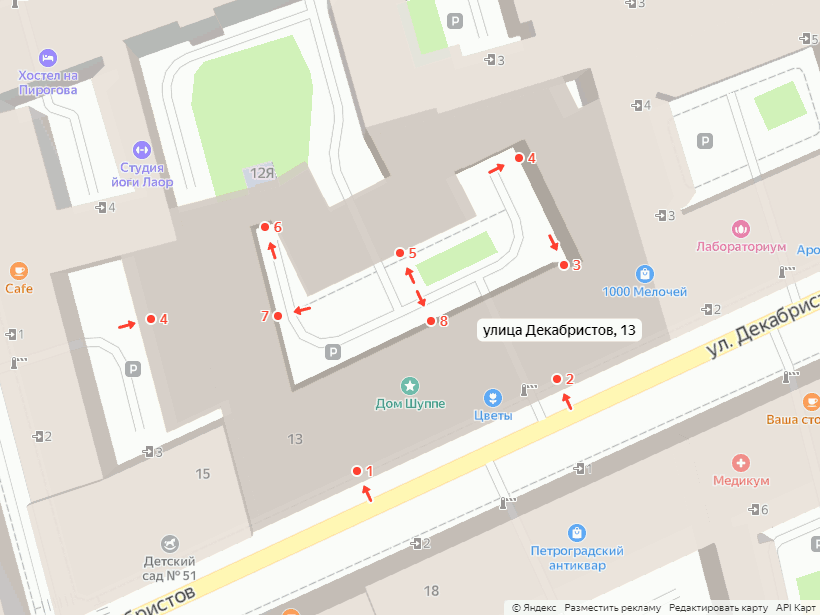
Интересно, откуда у Яндекса данные по подъездам? Некоторые тут говорят, какие у них замечательные данные. Действительно, часто их данные с реальностью совпадают, или в них можно найти лишь мелкие отличия. Но иногда их данные к реальности имеют отдалённое отношение.

Только что ввёл дом: из девяти входов у меня с Яндексом совпадают два (№1 и №7, ну можно засчитать ещё №2, если не смотреть на него относительно арки).

скриншот дома с подъездами из Яндекс-карт

See full entry

Вот продолжение моих попыток вводить POI сразу на месте из OsmAnd. В этот раз я обошёл вокруг квартала Московский-Смоленская-Заозёрная-Обводный. Этот заход оказался относительно успешным. Мне удалось ввести большую часть POI из тех, которые я бы ввёл обычным двухэтапным способом. Одна из причин успеха — в этом месте до меня было отмечено не слишком много POI. Соответственно, практически не возникало проблем сопоставления отмеченного с реальным. Одна из причин этой одной из причин — наличие свежепостроенных зданий, в которых очевидным образом не может быть обозначенных точек десятилетней давности.

Новые здания, как на Смоленской улице, также облегчают задачу сопоставления самих себя со своими образами на карте. Их обычно не строят в упор друг к другу, благодаря чему гадать об их границах не приходится. Зато там, где дома более-менее старые, что в моём случае наблюдается вдоль Московского проспекта, непонятные границы зданий возникают вновь. И, как обычно, далеко идти за ними не приходится. Начав обход с угла Московского проспекта и Обводного канала, прямо на этом углу я обнаружил дом № 62 со своим соседом № 64 или один дом № 62-64. Табличек с номерами там две,1 но это ещё не значит, что и дома два. Если таблички убрать, то, скорее, покажется, что дом один, если смотреть на него с улицы. Взгляд со стороны двора, возможно, произвёл бы другое впечатление, но я же не буду обходить каждый дом со всех сторон, когда ищу POI на улице. Но это ещё не самый сложный случай, потому что даже и с улицы ясно, какому месту соответствует видимая на карте граница между зданиями. Следующая же граница между домами № 64 и № 66 в том месте, где она нарисована, не видна совсем.

See full entry

В прошлый раз, про что написано в предыдущей записи, я попытался немного повводить POI из OsmAnd. Тогда я сразу же наткнулся на место, где мне не удалось ввести ничего. Может быть, мне просто не повезло, поэтому я попробовал ещё раз в другом месте — на Большом проспекте Петроградской стороны.

Опять соответствие точек

Теперь кое-что мне ввести удалось, но, конечно, не всё, что я бы ввёл дома из JOSM. Далеко идти до места, где потенциально вводимые данные приходится пропускать, не понадобилось. Уже через три точки передо мной встала задача сопоставления нечта под названием «Музей сновидений Фрейда» на карте с нечтом под названием «Институт психоанализа» в реальности. Институт теперь вместо музея, или музей всё ещё есть в институте? Ответ можно было бы обнаружить на сайте института, найдя там что-нибудь про музей. Заниматься этим и ему подобными вопросами, стоя у каждой редактируемой точки, весьма неудобно.

На самом деле, при более внимательном рассмотрении места табличку музея обнаружить можно.1 Она находится на двери под гораздо более заметной вывеской института. Получается, что я её не заметил с первого раза, но это ведь не проблема османда? Проблема эта, тем не менее, связана с процессом сбора и ввода данных при его использовании. Мне нужно на месте идентифицировать все POI, иначе я не смогу их ввести. Пока я их идентифицирую и ввожу, я не могу идти дальше. В отличие от этого, при обычном сборе данных я фотографирую все таблички, все вывески и все двери, так, чтобы иметь возможность разобраться с ситуациями одно заведение внутри другого потом.

See full entry

Некоторое время назад я начал описывать свой процесс сбора и ввода данных о POI. Само описание ещё далеко от завершения, хотя часть продолжения уже давно написана, но не опубликована. Там ещё много чего надо отредактировать, потом я решил написать другую запись покороче, но она получилась втрое длиннее последней записи про POI, и теперь я не знаю, когда доделаю и её. Сейчас я напишу кое-что на самом деле покороче.

Как и его описание, сам процесс обновления POI идёт с тормозами. Одна из очевидных причин этого — его двухэтапность.1 Сначала я иду на место и собираю там информацию о POI. Потом я иду за комп и ввожу собранную информацию. Это «потом» может наступить весьма потом или не наступить вовсе. Последнее происходит, когда данные достаточно устаревают из-за длительного срока с момента сбора или каких-либо существенных событий. Например, сейчас мне придётся выбросить данные, собранные осенью 2020 года. Летом того же года мне пришлось выбросить всё собранное до коронавируса.

Конечно, есть средства, позволяющие минимизировать количество возможных конфликтов от ввода старых данных, но сейчас я собираюсь написать не о них, так что вернёмся к двухэтапности. Двухэтапность это, вроде бы, плохо. Если бы я сразу вводил выясняемую на месте информацию, процесс шёл бы быстрее и с меньшим количеством потерь. И у нас же есть средства для ввода POI сразу, например, плагин редактирования в OsmAnd. Почему я им не пользуюсь?

Полунаписанная запись про особенности редактирования из OsmAnd у меня тоже есть в черновиках. Аналогичная ей про MAPS.ME уже давно написана. В ней в основном говорится о чужих правках, которые нам могут попасться, как они объясняются и что с ними делать. Сейчас же мы посмотрим на редактирование из OsmAnd с другой стороны — с сугубо практической для нас, на конкретном примере.

Конкретный пример

See full entry

Problems with level

Posted by Anton Khorev on 15 November 2018 in English.

There are problems with level=* tag stemming from the fact that not all mappers agree on what it means. This problem comes up more often in some geographic areas than in others where different floor numbering traditions exist. In this sense it is like name=* tag where certain parts of a name stop looking like parts of a name after being translated into a different language.

So what are exactly the problems with level=*? Some people think that the value of this tag should be whatever floor number that is used in place. You can usually but not always read it off some plaque, floor plan or elevator button. Other people think that the value should be a number such that the first floor at or above the ground level gets number 0, the floor above it gets 1 and so on. Those two different ways of assigning a value could be exactly the same, especially for English-speaking areas where they have a “ground floor” as level=0 and a “first floor” as level=1. If you are from those places, you may not even understand that there’s a problem. If you are from a place like Russia or the US, it’s evident for you that those ways are different. I’ll be using Russia as an example because it’s where I map.

But there should be no debate about the exact definition of level=* tag because we have a wiki where it’s perfectly documented, right? Not quite. First of all, we don’t have one wiki, we have multiple wikis in different languages. Those languages may correspond to areas with different floor numbering traditions, which in turn affects the wiki contents. Again, this is like name=*, where local wiki editors put their preferred spin on what should and what should not be part of a name.

See full entry

Теперь можно рассмотреть, какие осмовские данные я использую для записи информации о POI. Эти данные можно разделить на геометрию POI и их теги. Здесь будет рассмотрена геометрия, а теги будут в следующих записях. Как выяснится, геометрию можно задавать различными способами, так что прежде, чем рассказать, какими из них пользуюсь я, придётся их отдельно разобрать, на что уйдёт большая часть записи.

TL;DR

Основная задача: отметить POI так, чтобы её было как можно проще найти либо обнаружить её отсутствие или изменение при последующей проверке. В пределах проверяемых участков достигается заданием последовательности POI вдоль контуров зданий, которую удастся воспроизвести при проверке, либо в которой удастся заметить изменения. Последовательность создаётся заданием соответствия между POI как объектами, имеющими существенную площадь в масштабах зданий, и входами как точечными объектами на контурах зданий. Соответствие задаётся либо явно заданием entrance=* и его соединением с POI, либо неявно позиционированием POI рядом с местом расположения входа. В случае, если последовательность задать невозможно по причине отсутствия взаимно однозначного соответствия POI и входов, изображается структура проходов внутри здания, ведущих к POI. Также возможно использование дополнительных тегов для обозначения вертикального положения перечисленных объектов.

Куда ставить POI?

В осме все данные находятся в одном слое, из чего следует, что всё надо позиционировать относительно всего. В случае с POI, их приходится обозначать в первую очередь относительно зданий, которые, как правило, уже нарисованы. Есть, конечно, места, где за рисование зданий никто не брался, но при этом POI там пытаются обозначать. В тех местах POI приходится позиционировать относительно дорог, которые обычно рисуют перед тем, как берутся за здания. Но всё это является задачами первоначального наполнения данными, а то, чем занимаюсь я – это обновление уже существующих данных.

See full entry

Можно уже перейти к рассмотрению того, что я отмечаю при своих проверках POI, а заодно где и когда. Сразу надо предупредить, что если здесь написано, что я какие-либо объекты не отмечаю, то это не значит, что я их совсем никогда не отмечаю, это значит, что я не стремлюсь их отмечать при проведении проверок POI. Тем более это не значит, что я считаю, что они не нужны, и буду их удалять, когда они мне попадутся.

TL;DR

Что: любые стационарные точки ведения любого рода деятельности (в первую очередь – магазины, но также офисы) с присутствием персонала (не банкоматы, не торговые автоматы), видимые из свободно доступных для посещения мест, либо пожелавшие о себе сообщить любым способом в достаточно близком от себя месте (обычно табличкой) при наличии дополнительных способов верификации (обычно сайта).

Где: в данный момент – на территории Адмиралтейского и Центрального районов Санкт-Петербурга в первую очередь вдоль официальных улиц (согласно rgis), далее во дворах и ТК.

Когда: в какой-либо момент со вторника по пятницу с 11:00 по 18:00, при необходимости в другое время.

Что?

Целевые теги

Когда я пытаюсь написать, что я отмечаю, мне приходится говорить и о том, что я не отмечаю. Это связано с системой тегов в осме или, в ряде случаев, отсутствием системы. В данном случае, отмечаю я POI, а каким осмовским тегам это соответствует?

See full entry