OpenStreetMap logo OpenStreetMap

Branko Kokanovic's Diary

Recent diary entries

Maxspeed freshness tool

Posted by Branko Kokanovic on 13 September 2024 in English.

tl;dr I created Maxspeed freshness tool where you can see if maxspeed tag exists, and if it does - how old it is!

Worldview

Why this tool

This tool emerged from a need within the local community. In Serbia, we have more street-level cameras and volunteers capturing road data than ever before! We even have people actively editing data based on those captures (which are not necessarily same people😀). Good problems to have! The big question is: Where should we capture images next?

We needed a comprehensive view of highways missing maxspeed tags so that people could go there. Additionally, we noticed some major motorways had outdated information—some maxspeed tags hadn’t been updated in over a decade. Everything gets old, even maxspeed tags.

See full entry

Introduction

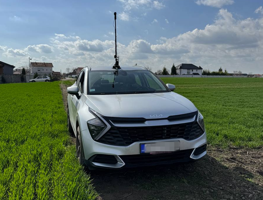
Car in action with Insta360 ONE

In this post, I will try to explain my process how to get best out of Insta360 ONE RS 1-inch camera and successfully upload images to Mapillary. It started out of my frustration of dealing with this camera and Mapillary and I hope you will not have to go through what I have been🙂. I will be focusing here more on software side (how to deal with data) rather than on hardware side (how to set up rig for image capture).

Let me first start with disclaimer that this is not easiest camera to work with Mapillary (hence this guide) and that not even Mapillary is recommending it. It definitively captures better images than GoPro 360, but everything with GoPro is more smooth over whole process, so be aware of this. Camera needs to record in video mode and it relies on additional GPS dongle you have to buy.

See full entry

Call for ideas from Microsoft

Posted by Branko Kokanovic on 11 December 2023 in English.

Hi,

My name is Branko from Microsoft. Microsoft’s involvement with OSM spans several impactful contributions:

  • Providing Bing imagery since 2010 for free use in OSM for whole world (and all the drama that comes with it)
  • Creating Map builder – intuitive editor for Bing users that want to edit OSM map (and all the drama that comes with it)
  • Maintaining iD in the interim period before Martin took over (sorry, no drama here, just plain good old maintainership)
  • Released world coverage of AI-mined building footprints and road data as open data

This list is not intended to be PR for Microsoft, and I know this sounds like a corporate cliché, but this list is hopefully showing that Microsoft is really committed to success of OSM. Stuff that we did previously, stuff in that list above, is stuff that we think will benefit the community and improve OSM contributions. And we hope it did! A lot of us recently visited SotM EU 2023 and I hope you saw us all around. That event allowed us to see stuff from a different perspective and to try to think out of the box. So, we thought, what if we pause trying to figure out what is the best way to improve OSM contributions on our own and instead - ask YOU how Microsoft can help!? Yes, YOU, the community, directly here in the diary😊. I know this may sound unconventional, but hey – OSM is also not the most conventional project out there, so we thought this might just be the proper way to gather interesting ideas.

See full entry

TL;DR

Watch https://peertube.openstreetmap.fr/w/56SduK2wYnnUesnSroucbd


I have one nice way of finding best routes for bike rides. It is a mix of BRouter and Strava heatmaps. Whenever I show this to someone, they think it is really cool, but I never shared it with a world. Finally I found time to record my process. You only need Strava account and web browser to create these routes. I still think it is the best way to explore routes on desktop, but let me know if you can beat this:)

15 min video with subtitles is here: https://peertube.openstreetmap.fr/w/56SduK2wYnnUesnSroucbd

Thanks for checking it out!

Mapping the city of Mladenovac

Posted by Branko Kokanovic on 11 December 2021 in English.

OSM Serbia community is having its first “official” tasking manager task. We are mapping small city of Mladenovac:

https://tasks.osm-hr.org/project/21

Tasking manager instance was kindly borrowed by Croatian community. Why Mladenovac? Well, we took Mladenovac as it had worst ratio of population/building at disaster.ninja:) If this is succesful, we thought that people who contributed the most choose next city:)

This is great as this will be good reference of what we can pull together and how many local people we can attract! We already took some nice “before” pictures, so it should be nice comparasion once we are done:) Feel free to drop by or ping here if you want to help out! Everyone is welcome:)

More details in Serbian here: https://openstreetmap.rs/mapirajmo-mladenovac/

Location: Banja, Mladenovac, Mladenovac Urban Municipality, City of Belgrade, Central Serbia, 11400, Serbia

TL;DR I wrote new console app that takes GTFS as an input and tells you exact changes you need to do in OSM to make it as close to GTFS as possible. Head to source to start using it.

Try it out on your GTFS and let me know how it went! I am open to suggestions, new ideas and new checks!

Description

Purpose of this tool is to help find errors and differences between GTFS and OSM data. It will also help point to errors in PTv2 routes in OSM. It covers wide range of errors, tag checks, geometry checks… (when I say “wide”, I really mean it! - check README.md to keep me honest, I am really proud what you can check today).

Once you import data in OSM (or when new version of GTFS data is released), you can use this tool to check if all data from GTFS is imported in OSM correctly and what are differences.

Tool is heavily relying on PTv2 spec and do not try to deviate from it. One would might say it is “opinionated”:)

This tool is not general-purpose PTv2 quality assurance tool, even though it points to a lot of PTv2 errors in OSM. It is handy if you are OK with console output and quick iterations as you can grep it, cron it, sed it as you like. Check this wiki for other great tools.

Why new tool

See full entry

Location: Skadarlija, Stari grad, Stari Grad Urban Municipality, Belgrade, City of Belgrade, Central Serbia, 11103, Serbia

I worked for some time to create Mapnik-based tileserver where names are internationalized. I managed to do it by pulling data from names from Wikidata and Wikipedia. Project is released at: https://gitlab.com/stalker314314/osm-wikinames

You can see showcases at: https://gitlab.com/stalker314314/osm-wikinames/-/blob/master/showcase.md

Idea is to create new columns in PostGIS which get populated from wikidata/wikipedia and then, use those columns in renderer.

Do check it out if you find this useful and submit issues if you see any bugs, or this doesn’t completely do the job for your case!