ClarkstonCorrect's Notes
Notes submitted or commented on by ClarkstonCorrect
| Id | Creator | Description | Created at | Last changed | |
|---|---|---|---|---|---|
| 1695984 | Google Maps |
||||
| 1670235 | MI AMIGO WIER DARLING |
||||
| 1814970 | this is farms not water |
||||
| 1812087 | ClarkstonCorrect | it seems to not let me add arran to the firth of clyde relation |
|||
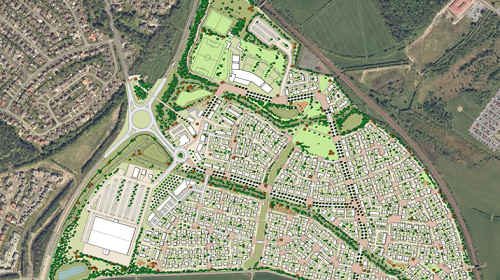
| 1813161 | ClarkstonCorrect | https://www.swanholdinggroup.com/wp-content/uploads/2019/02/Corton-FOR-WEB.png seems to end here, but there's clearly more to this development |
|||
| 1412161 | The name “Carradale Harbour” is not in the correct place. It should really be closer to/beside/on top of the Harbour itself. |
||||
| 981873 | Ignore previous note - now marked the M74 Slip Road position correctly. Apologies and thanks |
||||
| 592877 | John Middlemiss | Bield Housing |
|||
| 828869 | SK53 | This roads are more of a character of service roads than tracks. From memory I think the one to Knockharry is metalled (paved in OSM parlance). |
|||
| 97681 | SK53 | Mapping based on aerial imagery of 2012: construction should be completed by now (Jan 2014) |