Foomandoonian's Notes
Notes submitted or commented on by Foomandoonian
| Id | Creator | Description | Created at | Last changed | |
|---|---|---|---|---|---|
| 2349652 | Foomandoonian | Unable to answer "Is it restricted who may park here?" for osm.org/way/237919258 via StreetComplete 22.3: Parking temporarily (?) removed for construction site. |
|||
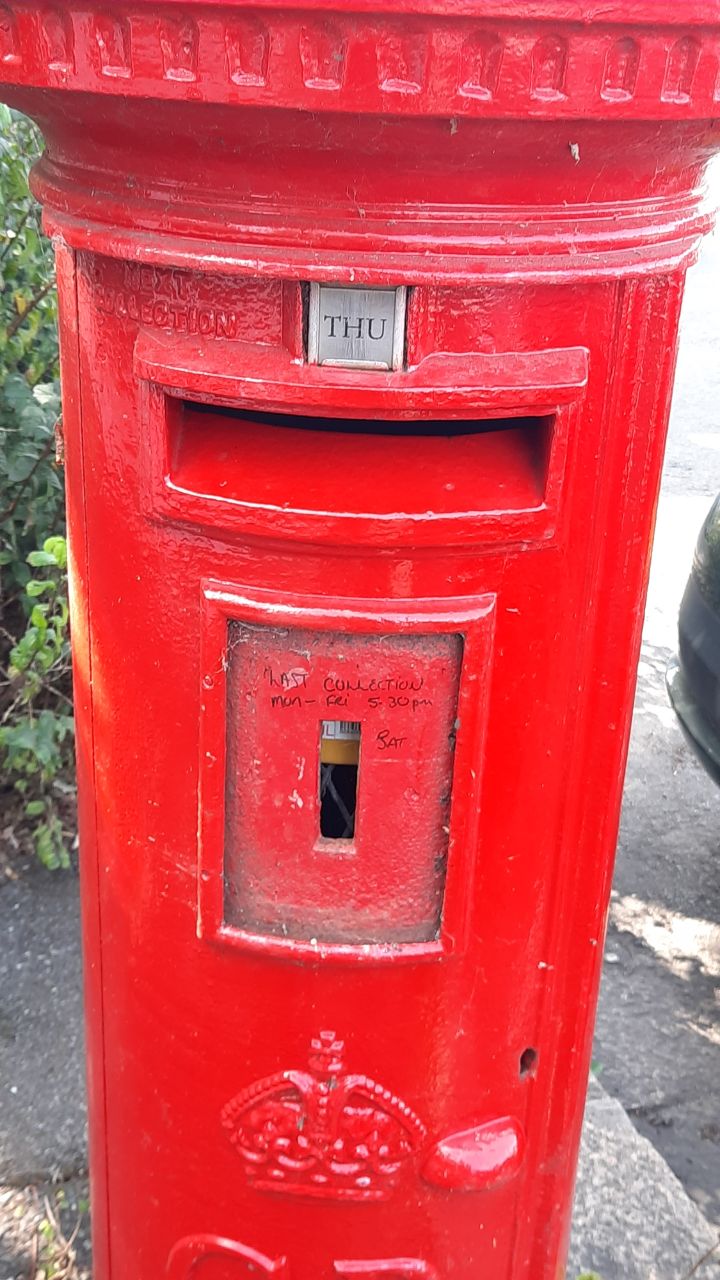
| 2351972 | Foomandoonian | Post box with missing info board. Seems still in service. M-F 17.:30, S ?? #postbox via StreetComplete 22.3 Attached photo(s):
|
|||
| 2622579 | Foomandoonian | Unable to answer "What religion is practiced at Kingdom Hall?" for osm.org/node/6444862028 via StreetComplete 31.2: No obvious signage outside. look like private residences |
|||
| 2620886 | Foomandoonian | Additional track via StreetComplete 31.2 Attached photo(s):
|
|||
| 1715123 | This is listed as The Wistleton Inn. There used to be a Whistlestop Inn "opposite" Portslade Station, which has (though possibly back in Dec. 2015!) been refurbished, and is now The Railway Inn "2 Boundary Rd BN41 1GA". The fact that, on this map, Boundary Rd fuses with Stn. Rd further south, and that Victoria Rd is an obvious point where the streetname-change might actually happen, PLUS the location right by a junction, consistent with its being No.2, might suggest a few slight errors. I'm not a local: someone who uses The Railway as a music venue gave me this info. |
||||
| 2659487 | Foomandoonian | Unable to answer "What is the name of this pedestrian street?" for osm.org/way/239051488 via StreetComplete 31.3: change to service Rd. no name. |
|||
| 2596778 | Foomandoonian | Outbuildings have been added from here, eastward, replacing the outer path. via StreetComplete 31.1 Attached photo(s):
|
|||
| 2351977 | Foomandoonian | Upper Drive #busstop 47, 59
via StreetComplete 22.3 Attached photo(s):
|
|||
| 2625690 | Foomandoonian | check: add bike ramp to step details. via StreetComplete 31.2 Attached photo(s):
|
|||
| 2630175 | Foomandoonian | Access to superman from car park via StreetComplete 31.3 Attached photo(s):
|