OpenStreetMap logo OpenStreetMap

GOwin's Diary

Recent diary entries

Mayon Maping Update

Posted by GOwin on 24 January 2018 in English. Last updated on 28 February 2018.

The areas surrounding Mayon volcano is still in Alert Level 4, which means an imminent hazardous eruption is expected.

Mayon Mapping Status, 2018-024 https://tasks.hotosm.org/project/4037

We’d like to share the progress of the hard-working humanitarian volunteers who has already mapped 91% of Mayon’s Extended Danger Zone 0. Last week, volunteers also completely mapped Mayon’s Permanent Danger Zone 1. We’d like to especially acknowledge the big mapping boost we got from the DevSeed data team from Peru.

The southern section of the EDZ, considered as high priority because of the settlements within, are now 100% complete, and validated.

See full entry

Location: Camalig, Albay, Bicol Region, 4502, Philippines

Very active mapping activity around Mayon, in the last several days.

We are grateful for the help extended by very dedicated mappers all around the globe, for helping map the Permanent Danger Zone around Mayon. This has been 100% validated today.

Mt. Mayon is still a looming threat for many towns and small settlements in its vicinity, and we have an on-going mapping project to map the Extended Danger Zone. And because of the positive response from the community, we’re now halfway done, and would welcome extra helping us to make this complete as soon as possible.

Kudos to Maning Sambale for initiating this activity, to make available Free and Open geodata to local governments and humanitarian organizations for their disaster management planning, and response.

Thank you.

Location: Camalig, Albay, Bicol Region, 4502, Philippines

Mt. Mayon ash plume. Photo credits: unknown.
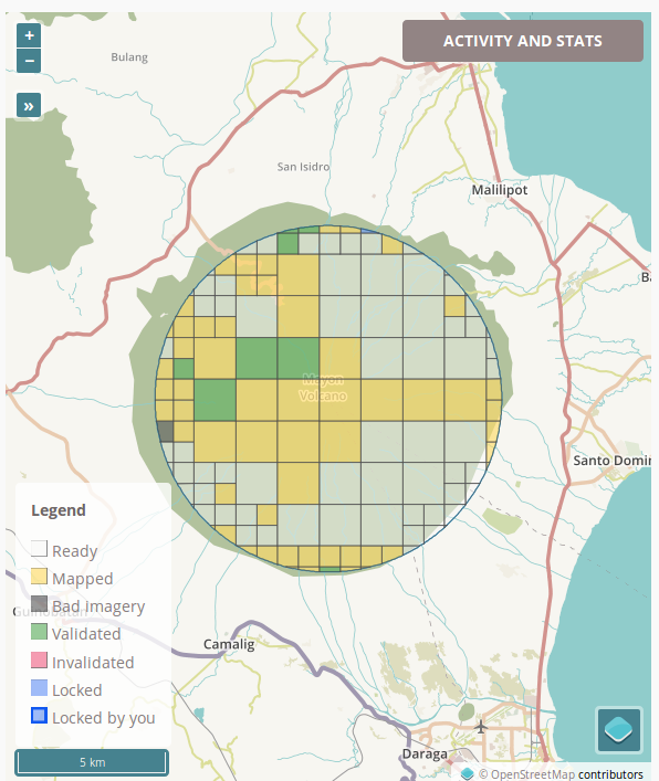
Mayon, the Philippines most active volcano, with 48 historical eruptions is restive. Over the weekend, tremors, lava fountaining, and lava collapse events has been noted. Government volcanologists report that “relatively high level of unrest as magma is at the crater and hazardous eruption is possible within weeks or even days.

The authorities has prohibited the public from entering the 6 kilometer-radius Permanent Danger Zone (PDZ), and the 7-km Extended Danger Zone (EDZ) on the southern flanks “due to the danger of rockfalls, landslides and sudden explosions or dome collapse that may generate hazardous volcanic flows.”

Yesterday morning, we appealed for help to map the 6-kilometer Permanent Danger Zone of Mayon, and the community responded quickly. Today, it’s been 100% mapped, 57% validated (and still on-going). Thank you! The names of the generous mappers may be found in the project dashboard.

See full entry

Location: Camalig, Albay, Bicol Region, 4502, Philippines

Missing Highways in Metro Manila, PH, and neighbouring provinces.

Posted by GOwin on 14 January 2018 in English. Last updated on 24 January 2018.

Last week, we shared a a tasking project to update missing highways in Metro Manila 0 in the local mailing list. We’ve also published a few more tasks to cover adjacent provinces:

The data is not perfect, and you may even encounter false positives, but it’s pretty good with pointing out a good number of missing roads in essential areas that local mappers have yet to digitize.

These are all part of the on-going initiatives by Kaart, to make awesome data for PH, and help grow local mapping communities.

If you’re keen on improving the map of your home town or province, and they’re not on this list yet, please let me know so I can put them up sooner rather than later, and we can work together in filling-in gaps in your favorite neighborhoods.

How about a mapa-thon soon? I’m planning to organize one, primarily to work on these tasks, and for the community to meet each other, and maybe welcome new ones. Would you folks have any suggestions, or is your org interested in collaborating? Let me know.

See all the Missing Highways tasks in PH. Do email me for any concern, or other questions, about these tasks.

Location: Daang Bakal, Mandaluyong, Eastern Manila District, Metro Manila, Philippines

Geoweek 2017 with students from the University of San Carlos [Cebu, PH]

Posted by GOwin on 24 November 2017 in English. Last updated on 14 January 2018.

Earlier today, we (belatedly) celebrated Geoweek 2017 with students from the University of San Carlos of Talamban, Cebu. Many thanks to Ms. Rose Lapad (Cebuano Studies Center) and Ms. Lalia Labajo (Chairperson, Department of Anthropology, Sociology and History) for accommodating the mini workshop to introduce OpenStreetMap to their students.

We were able to do basic editing with iD, work with the Tasking Manager, and capture a few Mapillary imagery of the campus, plus the usual Q&As for beginners. >Group photo of participants of the Geoweek micro-workshop. © 2017, Debra Ouano. >image

See full entry

Location: Nasipit, Cebu City, Central Visayas, 6014, Philippines

#geo4kids - teaching kids basic geography

Posted by GOwin on 15 October 2017 in English.

geo4kids

Our Zen Center hold a regular outreach progam for kids called Bodhi Star. Along with teaching basic mindfulness techniques, life-skill ideas and concepts are also taught or introduced.

Yesterday, it was my turn to teach skills class and I’ve always been keen on teaching something related to maps and geography.

The kids had great fun trying to identify objects from aerial imagery, “visiting” remote places, and wonder about the beauty of our vast, interconnected world.

Some of the places we visited had limited street-level imagery, which they were quite fond of, so I even got to discuss Mapillary with some of them - who wanted to capture images of their neighborhood. There are plenty of caveats, of course, and there are parents around to keep them grounded.

I should seriously plan for a Mapillary field-trip idea for kids.

See full entry

Location: Little Baguio, 2nd District, Eastern Manila District, Metro Manila, Philippines

OSM PH-izza

As always, the local OSM community in the Philippines is keen in finding ways to engage, and expand the community of OpenStreetMap contributors in the country. Many mapa-thons and hacking events are fueled by passion, and pizza. You can help drive the passion, and we’ll take care of the pizza.

We just launched a new program: the OSM PH-izza Challenge that offers to send free ph-izza for mapathon events in every possible part of the country - especially those outside Metro Manila. If the mapathon proposal is selected, the PH-izza is on us!

We’re hoping to select at least one event every month - and we’d like to hear your proposal!

If your group or club would like to send your proposals, please fill-in this application form so we can evaluate your them: https://goo.gl/forms/si06mto1fOkeY3652

P.S. We would also be very happy to hear from pizza-hearted sponsors who would like to help us expand this program!

Fire-fighting assets mapping with the Davao City Fire District - Hail Hydra(nt)!

Posted by GOwin on 13 September 2017 in English. Last updated on 27 July 2018.

This post is a month overdue. I was in the Davao region last August (for business), but I thought I should touch bases with a few local organizations, including the local fire department, to chat about OpenStreetMap, since I’m there anyway. :smile:

My inquiries were enthusiastically received by the local fire officials as I introduced the goals of the HailHydra(nt)! initiative, and they decided they’re willing to host a mapa-thon. We set it during the city’s annual Kadayawan Festival.

Looking back, I should’ve pushed for another date. With many other departments busily attending to their own programs and tasks for the said activity, we ended up doing the mapping ourselves, instead of the expected participation of other orgs, we still managed to complete the goals we set for the day, with a little overtime :grin:

A Fire Hydrant Network base map

The main objective is to map the fire hydrants of the city, and complete the map of the fire stations and volunteer brigades operating in Davao.

See full entry

Location: 27-C Santa Ana, Poblacion District, Davao City, Davao Region, 8000, Philippines

Hail Hydra(nt)! - GenSan edition

Posted by GOwin on 29 July 2017 in English. Last updated on 31 July 2017.

I am visiting General Santos City for some research but, unexpectedly, we completed our tasks much earlier. I had lots of time to kill, and reached to a local university (Notre Dame of Dadiangas) and offered to conduct a workshop on FOSS/Participatory Mapping for their community. Unfortunately, because of the short notice, and their other commitments they were unable to accommodate the request.

image Diligent RAs made quick work of our tasks

See full entry

Location: General Santos City Government Center Compound, Dadiangas West, General Santos, Soccsksargen, 9500, Philippines

City Mapa-thon: (San) Juan more time!

Posted by GOwin on 13 June 2017 in English. Last updated on 14 June 2017.

Thank you to all the participants who spent their Saturday afternoon with us, mapping the city of San Juan, over Independence day weekend. We’re also thankful to San Juan City (and their DRRMO) for making the venue and facilities available.

And a shout out to Mapillary, for the refreshments.

This is the second city mapa-thon, and a follow-up activity to enhance the Free/Open data collection of the city of San Juan, and to complete the leftover tasks from the last mapa-thon, chiefly working in the second district of the city: >image > 
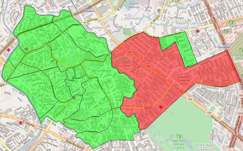
Shown here are the 21 barangays of the city, using the MapCraft tasking manager >Data © OpenStreetMap contributors (ODbL); Image © MapCraft

See full entry

Location: Corazon de Jesus, 1st District, Eastern Manila District, Metro Manila, Philippines

OSM x GM's "glitch"

Posted by GOwin on 8 June 2017 in English. Last updated on 22 June 2017.

I just finished reading Side-by-side images expose a glitch in Google’s maps which highlights some shortcomings of Google Maps (GM), which the writer call as “glitches”.

I find that amusing because I often hear the same assertions against OSM. Immediately, I wondered how the OSM community is faring in those same areas:

Morro dos Prazeres

image © 2017 BBBike.org & Geofabrik GmbH - map data (©) OpenStreetMap.org contributors

Makoko, Lagos

See full entry

Location: Santa Lucia, 2nd District, Eastern Manila District, Metro Manila, Philippines

San Juan City Mapa-thon for Disaster Risk Reduction and Resiliency Programs

Posted by GOwin on 30 May 2017 in English. Last updated on 2 June 2017.

Keeping up-to-date, relevant maps, is a challenge for many organizations, especially if they don’t have the in-house capacity, or the resources to systematically maintain geo-spatial datasets that are useful across multiple departments or end-users. This is not an uncommon scenario in many municipal governments in the Philippines.

Over the last several months, the MapAm❤re Initiative in San Juan, have been collaborating with local actors and promoting Free software, especially OpenStreetMap, to communities who are seeking to make the most of what’s possible with Open data.

Last Monday, we’ve successfully concluded a City Mapa-thon for DRR to help the local government, in particular the City Disaster Risk Reduction Management Office in creating and updating the map features necessary for their risk reduction and resiliency programs.

87% of the people who registered for the mapa-thon made it to event. Thank you to everyone who chose to spend their Monday afternoon with us, helping out the city of San Juan.

Thank you, too to the City DRRMO, for hosting the event and making their facilities available for the volunteers.

A big thank you to our generous benefactors who sponsored the pizza and drinks. And a shout-out to Mapillary, for the swags we raffled after the mapa-thon. Maraming salamat!

See full entry

Location: Corazon de Jesus, 1st District, Eastern Manila District, Metro Manila, Philippines

Bayanihan Mapping Workshop in Batangas City

Posted by GOwin on 3 May 2017 in English. Last updated on 23 May 2017.

Ala eh OSM - the Basic Mapping Workshop

imgAOI Click the image to view the details via Overpass Turbo query.

Last week, a few OpenStreetMap advocates from Metro Manila made a trip to Batangas for a training engagement with the Bayanihan Mapping Workshop co-organized by MapPH and their partners. OSMph has had extensive engagements with some of MapPH efforts in the past years, and we continue to work with them in common spaces where we can collaborate.

The workshop was attended by over fifty enthusiastic participants, mostly from the respective Disaster Risk Reduction Management (DRRM) office, or the Planning and Development offices of the local government units within the Taal Volcano Protected Landscape (TVPL), about a third of the municipalities of Batangas province:

  • Agoncillo
  • Alitagtag
  • Balete
  • Cuenca
  • Laurel
  • Lemery
  • Malvar
  • Nasugbu
  • Taal
  • Talisay

See full entry

Location: Barangay 20, Poblacion, Batangas City, Batangas, Calabarzon, 4200, Philippines

print-fold-paste-💢💣💥-paste-fold map

Posted by GOwin on 16 February 2017 in English. Last updated on 17 February 2017.

dymaxion on icosahedron

It’s almost easy, and definitely fun if you have an hour or so to tinker. ;)

I’ve been trying to look for a mapping activity for kids 6-12, and I remembered a project I saw in an OSM blog 0, and thought I’d try it out.

This is better suited for 11+ years old, including some adults. Maybe.

H/T to smaprs.

Note to self: a bigger paper could make this a lot easier.

Source: https://plus.google.com/+WinOlario/posts/d8fjiGtsdjK

Location: Wack-Wack Greenhills, Mandaluyong, Eastern Manila District, Metro Manila, Philippines

Map of eastern Mindanao, 1856. José Algué >A beautiful hand-draw map of eastern Mindanao by José Algué, from Atlas de Filipinas, published in 1899

About

The Asia Foundation (TAF) in the Philippines, with the support of the Coordinating Roads and Infrastructure Investment for Development (CR+ID) project of the Australian government continue to promote a crowd-sourced industry mapping model, using the OpenStreetMap platform, to spur the economic and social development of local government partners and communities.

Early this year, TAF organized another workshop in Butuan for the provincial government officers and staff in Caraga, along with representatives of the local chambers of commerce to en-vigor previous efforts to collect geo-spatial data, including road networks, along with industry development maps, for every province in the region.

Between the 22nd to the 25th of February, the southern provinces of Caraga hosted an OpenStreetMap Workshop in Prosperidad, Agusan del Sur and Tandag, Surigao del Sur.

See full entry

Location: Bolhoon, San Miguel, Surigao del Sur, Caraga, Philippines

Bogo OpenStreetMap Workshop

Posted by GOwin on 21 February 2016 in English.

Butuan Edits

Bogo OpenStreetMap Workshop

The other week, the Philippine Red Cross, with the support of Croix Rouge Francaise, organized and hosted a Risk Mapping workshop using OpenStreetMap in Bogo City, Cebu, part of their Bogo - Northern Cebu Risk Mapping project which intends to improve and update the free and open geospatial data sets in Northern Cebu for humanitarian response. Participants included select local Red Cross volunteers, LGU workers from the barangays and municipalities of Bogo, Daanbantayan, and Bantayan.

See full entry

Location: San Vicente, Bogo, Cebu, Central Visayas, 6010, Philippines