GOwin's Comments
| Post | When | Comment |
|---|---|---|
| AI With Satellite Images for OpenStreetMap | I’m excited to hear more about this, and how it can help improve AI for tracing imagery! Eventually, I see AI being just as capable as human mappers with mapping certain features. |
|
| OSMCha News - February/2018 | Very useful updates! Thank you. |
|
| No, there's still more! | Persistence is a virtue. Theirs, and yours. ;) |
|
| Responding to the collaborative mapping in Peru | That’s awesome @karitotp. Thank you, too, for your team’s awesome help in our mapping effort around Mayon Volcano, in the Philippines. |
|
| My first OSM Tracking experience :) | That’s awesome! And it sounds like you had fun. Keep it up. Connect with like-minded active mappers in Asia in our Telegram community: https://t.me/OpenStreetMapAsia |
|
| Reflections on 10 years of a changing Open Source Map | Another one of the awesome OSM folks! Kudos for staying on, and thank you for your contributions. Good luck with your map everyday goal. |
|
| Days of mapping: Batangas City (December 2017) | Good job! And thank you for your many contributions. |
|
| Bayanihan Mapping Workshop in Batangas City | @TagaSanPedroAko Your contributions to the map are awesome, and you also help out in adding details in the wiki pages. Thank you! I’m still wondering what happened to the Batangas City’s government effort to update the OSM map. They don’t appear to be making any updates since August 2017, and last I checked, their edits still needs some fixing. It would be great if active mappers can reach out again to them, and explore how to collaborate. I hope we can meet you IRL, one of these days. Happy new year! :) |
|
| Using OSM in Mobile | OsmAnd is an open source software. There’s [Osmand~(https://f-droid.org/packages/net.osmand.plus/), that is community-maintained and hosted at F-Droid. It has all the features of Osmand+, and without the limitations of the regular version found in the Play store (i.e. download limits, absence of Wikipedia support, etc.) The only slight disadvantage with this version, is that it takes a few days (or weeks) to get the new features found in the + version. OsmAnd is a very mature app, and this isn’t a big deal for many people. P.S. I support the development of Osmand by paying for Osmand+ , but I use and promote the OsmAnd~ version, and I recommend you do the same. |
|
| Editing in OSMAnd | I am not fond of advanced editing, or drawing polygons on a mobile or tablet device. That said, I’m fine with OsmAnd not having said feature. I’m pretty sure I can draw the same polygon, with better details, and with less time and effort on my computer. ( An editor I really like is Go Map on iOS, and Vespucci) I never found the hourly subscription necessary. I can either wait for the monthly update, or in a pinch, download a customized OsmAnd database, anytime, using the HOT export tools. The power features of ~OsmAnd (from F-Droid, although I paid for the app, and can use the OsmAnd+ version) are great for those who use them, but there are other better looking renderers, and more user-friendly options available. |
|
| Geoweek Mapping Party with Grab, MapPH, and OSMPH | @grass_and_green Interesting. How do you intend to use this data, where can we get more information about your project, and where do you intend to publish the results? |
|
| Geoweek Mapping Party with Grab, MapPH, and OSMPH | Kudos! Which Tasking Manager instance is this on, Feye? |
|
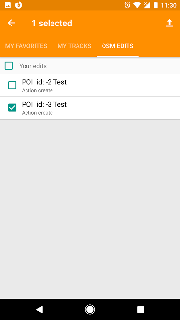
| Editing in OSMAnd | OsmAnd is also a favorite editor on Android. You can add multiple POIs in a single changeset, what you do is to simply continue adding the POIs without uploading each individually, and when you’re complete, go to Menu > My Places > OSM Edits where you’ll see all the saved edits you’ve made. You can choose what to upload, or select everything. You leave any appropriate changeset comment that describes the edits you just made, and then optionally close the changeset. Once you hit ok, you can no longer modify a changeset comment.
|
|
| The only phone that doesn't like cobblestone | Great tip! Thank you. |
|
| Maps, Kids and Humanitarian Outreach | Thank you for sharing! But why are you copying and pasting content, when you could have simply shared a short summary, and a link to the original site with richer content? https://media.ifrc.org/innovation/2017/07/03/maps-kids-and-humanitarian-outreach/ Anyway, “whiteboard mapping” is an interesting approach. I hope we could try that out ourselves in one of our local outreach activities. |
|
| OSM Training at Eastern University of Sri Lanka in Batticaloa | From our own community experience in the Philippines, we don’t JOSM as inappropriate for beginners - provided there’s enough time to provide proper training, and guidance. The caveat is that, it’s challenging to teach it in one day (but not impossible). During any training activity, we try to remind participants that we often work with live data, so if they are unsure about their work, they can ask for assistance from workshop facilitators. So what drives our choice of editor when running OSM training?
|
|
| Get the gps coordinates for a region/state, area etc | P.S. Welcome to OpenStreetMap! |
|
| Get the gps coordinates for a region/state, area etc | Stephan is likely to be right, and you can do that next time. Check out http://bboxfinder.com . It should be able to do what you want. |
|
| New to all this | Welcome to OpenStreetMap! |
|
| Hydranten in Friedrichshafen | You may also use Overpass Turbo to extract the actual data, and do other stuff with it. Try out this query. |