InfiNorth's Notes
Notes submitted or commented on by InfiNorth
| Id | Creator | Description | Created at | Last changed | |
|---|---|---|---|---|---|
| 4358072 | Way #124947834
key:name - Kamloops RCMP |
||||
| 4248118 | There is a new separated bike lane that can be added to the map, running along the east side of 6th Avenue from Lansdowne St to Columbia St. Newer street view images on Google Maps show the roadway changes that have been made along 6th Ave. https://www.kamloops.ca/our-community/news-events/news-releases/separated-bike-lane-opens-6th-avenue |
||||
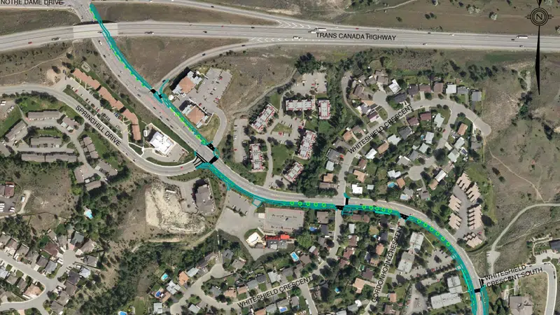
| 4268566 | Several nearby bike connections are shown incorrectly. 1138519886, 999222337, 999222338 should be foot paths only. They are standard sidewalks, the wider multi-use pathway that allows bikes runs along the east side of Summit Dr in this section. Multi-use pathway visible in blue in linked image: |
||||
| 4289431 | Springhill Drive now has a curbside bike lane in both directions between Sedona Drive and Summit Drive. Visible in Google Maps street and satellite views. |
||||
| 4513747 | This is a separated cycling lane. |
||||
| 4322638 | smithkm | Tagging Bastion Square as one big pedestrian area obscures the presence of many stairs and ramps connecting different parts of the square. |
|||
| 4059276 | Mateusz Konieczny |
Is bicycle_parking=anchors really correct here? In case that it is a correct tagging - can you make photo and upload it to Wikimedia Commons or make it available on open license in other way? I want to add it to OSM Wiki documentation and so far I was unable to find even single actually correct bicycle_parking=anchors |
|||
| 4289619 | smithkm | This section of Cedar Hell Cross Road is taged as 30 km/hr, but https://www.saanich.ca/assets/Local~Government/Documents/Bylaws~and~Policies/streets-and-traffic-regulation-bylaw-2002-no-8382.pdf says it should be 40, need to check signs to confirm |
|||
| 4520283 | InfiNorth | Construction underway here - new multi-unit condo/townhome |
|||
| 4266776 | smithkm | Need to ground truth the bays and their relationships to routes. The map on the BC Transit website shows no Bay G and none on the east side of Government. |