Mateusz Konieczny's Comments
| Post | When | Comment |
|---|---|---|
| Road names | Yes, if road has no name then adding name tag is wrong. Though without details it is hard to say more - for example road may have no official name, and have locally used name. Adding it as name tag is perfectly fine. See description and noname tags. |
|
| Happy 10th anniversary Vespucci! | Thanks for Vespucci! It is great for editing during survey, preferable to making many, many notes and later deciding to not spend my time on processing them :) |
|
| Connecting Communities With Improved OpenStreetMap Credits on Mapbox Maps | Just use the same way of detecting resolution as is used to display Mapbox logo and everything should work well (and if Mapbox logo is always displayed them OSM attribution also should be always displayed). |
|
| Connecting Communities With Improved OpenStreetMap Credits on Mapbox Maps | I am not sure how it changes anything. There is still enough space to display attribution. |
|
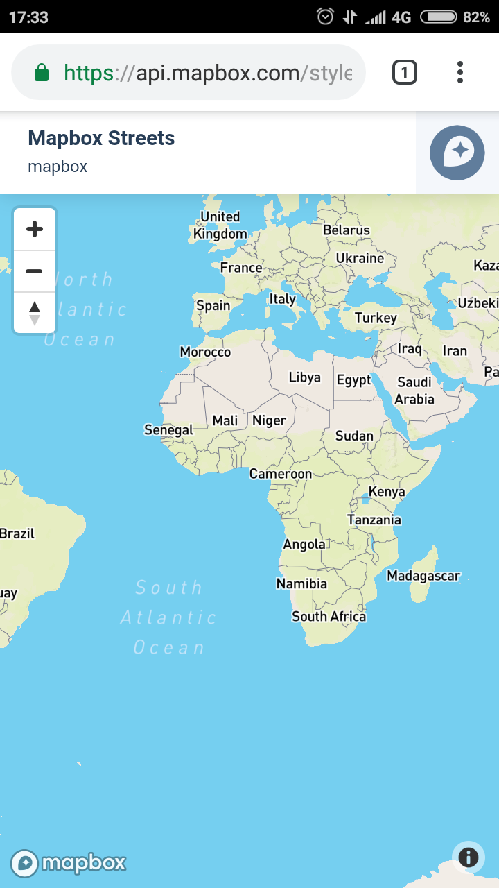
| Connecting Communities With Improved OpenStreetMap Credits on Mapbox Maps | osm.org/user/lxbarth/diary/21847 Note also https://docs.mapbox.com/help/tutorials/first-steps-android-sdk/ First image presents map made from OSM data misrepresented as a Mapbox data. I request fixing this. https://docs.mapbox.com/help/img/android/android-first-steps-intro.png |
|
| Connecting Communities With Improved OpenStreetMap Credits on Mapbox Maps |
Mapbox is still not properly attributing OpenStreetMap in its own examples. For example at my Xiaomi Redmi 4 (5.0 inches, 68.9 cm2 screen with 1080 x 1920 pixels) there is more than enough space to display proper attribution but it is collapsed. Is it a bug or a desirable decision? Note that on map there is a large Mapbox logo that is displayed. I informed Mapbox via mapbox.com/contact/support/#attribution and received no useful reply. Contact dropped after on 24th January I asked
Screenshot of how map appears for me is at https://user-images.githubusercontent.com/899988/51281667-67210a80-19e3-11e9-807a-480de4fa8eea.png
It is barely acceptable on extremely small maps. Even on smartwatches it is possible to easily fit readable “© OSM” |
|
| Github HowTo: Clone Repository then make a Pull Request | Thanks for contributing your changes and helping everybody else! Especially as it required you to go through the entire setup process. git is powerful and useful (especially in programming) but noone sane will call it friendly to beginners - it is mostly result that it was created to support work of experienced programmers in developing Linux, so focus was on “fast, powerful, flexible” rather than on “newbies will not run away”. Hopefully https://github.com/gravitystorm/openstreetmap-promotional-leaflets/pull/5 will be merged soon. |
|
| The history of HOT US Inc governance - not to be replicated in OSMF | osm.org/user/sev_osm/diary/42854 link is not working |
|
| Fonts missing from OSM Promotional Leaflets | I created https://github.com/gravitystorm/openstreetmap-promotional-leaflets/issues/4 to suggest improving documentation, make finding this easier for other people who will attempt to run reprint and and to notify author that the published materials are still useful. |
|
| Neutral ground | “OSM wiki mentions that countries are defined as such according to UN decisions” - because this is the simplest way to stop micronation nonsense, without problematic side effects. |
|
| Towards a dedicated public issue tracking/project management system for OSM | Is phabricator less programmer-centric? As far as I can say it is not less programmer centric and it is more complicated. I think it would not solve the problem of “too software developer focused”. It may solve “external login” and would solve two other mentioned issues but at cost of maintaining one more service and even more increased complexity of a platform. |
|
| Neutral ground | “Internationally recognized =/= internationally recognized physical control. First is a common term from the legal documents concerning borders, it is explained in detail in Wikipedia and mentioned in the policy. Second is something Andy invented by knowingly misinterpreting the policy to prove his claim. There is no such concept.” I still see no evidence for “Second is something Andy invented by knowingly misinterpreting the policy to prove his claim” And such concept clearly exists, though there may be a better name for it to avoid confusion with legal recognition. |
|
| Neutral ground | “he outright misinterprets the policy to support his claim” I see no evidence of that. Are you seriously claiming that Russia is not controlling Crimea (“meets realities on the ground, generally meaning physical control”)? |
|
| SEO Work Hours | Have you reported them to DWG? |
|
| Neutral ground | @Kilkenni “DWG violated their own policy” - [citation needed] @”I don’t care any more what you can possibly say.” - While strategy “I will threaten everybody and in case that it failed to work I will continue with increased violence” unfortunately works so far for Russia, but I would not recommend it for you, especially in OSM. “From now on, you are an accomplice.” - please immediately cease claiming that people are accomplices of aggressive, dangerous and degenerate regimes in cases where it is not true. In case of Abkhazia there is also case of recent war (with Russia, again) and Russia ongoing attempt to encroach in the border zone. But case of Transnistria is relatively simple. |
|
| Problems with level | @Stalfur Not in, for example, Poland. |
|
| Announcing the DWG's new Organised Editing Guidelines | So to be clear - the policy was rewritten as demanded by
who
? |
|
| Announcing the DWG's new Organised Editing Guidelines |
Can anyone explain reason for changes since that first draft? Because I see no improvements anywhere, but maybe I missed something. |
|
| Announcing the DWG's new Organised Editing Guidelines |
I can announce plans on my private closed forum, treat lack of reaction as agreement. And if anyone complains I can find some emergency anyway. And that would not violate anything in “Informing the community”. |
|
| Announcing the DWG's new Organised Editing Guidelines |
This is utterly unacceptable and absurd. It is a perfect excuse for HOT and there is an already problem with low quality mapping and undiscussed imports in this area of an organized mapping. Can someone give an example of any real problem that this would solve? Because for me it is massive “feel free to ignore all weak suggestions here”.
Using “should” instead of clear “must” is unacceptable here.
Again, weak “should” is absurd and will lead to weaseling. |