OpenStreetMap logo OpenStreetMap

Sanderd17's Diary

Recent diary entries

New Open Data for Flanders

Posted by Sanderd17 on 4 December 2015 in English.

Today, the GRB database was opened to the public on the Flemish Open Data license (which is compatible to ODBL).

The GRB is a massive dataset, it contains many different types of data:

  • Administrative parcels
  • Building outlines
  • Building-attachments (stairs, roofs, …)
  • Man-made objects: bridges, chimneys, water towers,
  • landuse: railway-areas, highway-areas, residential, natural, recreational, …
  • road-related features: bus shelters, bicycle parkings, curbs, guardrails, poles, manholes, …
  • highway and waterway areas and center lines and even more

Of course, it will be a massive job to figure out how the relation to OSM is, and if the features can be imported in some way. But I think we’ll be able to handle this.
See full entry

Location: Lint, Schiplaken, Grimbergen, Halle-Vilvoorde, Flemish Brabant, 1850, Belgium

Address evolution in Belgium

Posted by Sanderd17 on 5 February 2015 in English.

As there has been an Address import in the Brussels region, and the Flemish Agiv also opened a database with address positions (not good enough to import directly, so we agreed to draw the buildings from aerial imagery while adding addresses, that way we at least check consistency of addresses). In Flanders, it’s a slow import that started around the end of 2014.

So I wondered what evolutions were visible lately. If it was possible to see where people were editing. Stuff like that.

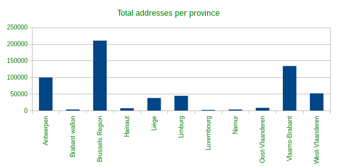
First I investigated the total number of addresses per province. Brussels capital region doesn’t have any provinces, nor does it belong to a province (although it’s completely enclosed by one). But Brussels is included next to the provinces, just to cover Belgium completely.

Total

See full entry