SomeoneElse's Comments
| Post | When | Comment |
|---|---|---|
| Community.osm.org - how's it going? | @Firefishy - Re “virtual categories” I added them into the “good” part of the list just before your comment, but as an example, “Garmin” is still a bit hidden. Search for the text on https://community.openstreetmap.org/ and you won’t find it. Typing it into the search box finds 6 items - one is a tag (but it does not say that it is a tag) and 5 are users (but it does not say that they are users). Of course, the decision not to have a Garmin category (just a tag) is a local deployment decision, and I’ve steered clear of talking about those above to avoid muddying the waters between “Discourse the software” and “how we have deployed it”. |
|
| Seen on my (virtual) travels 3. Old Windmills on Anglesey |
FFS - you’ll be adding “(closed)” after the name next :)
Ahem: https://map.atownsend.org.uk/maps/map/map.html#16/53.1671/-8.0244 |
|
| How do I revert this fellow's change? | A visualisation of the deletion is https://overpass-api.de/achavi/?changeset=101625624 . osm.org/way/842886190 was mapped as “informal=yes; surface=gravel; trail_visibility=intermediate”. It doesn’t have a “foot” access tag; I guess that would still be “yes”, even though it’s informal? Various options exist for undeleting the trail exist, such as the undelete plugin in JOSM. However, even if it makes sense to do that it might be useful to review the route - there are a couple of river crossings either side of osm.org/node/7863138316 that might benefit from looking at. However, I’d also suggest reviewing it in the light of osm.wiki/United_States/Trail_Access_Project and especially osm.wiki/United_States/Trail_Access_Project#Trail_Tagging_Chart within there. It’s definitely worth discussing the status of it with other mappers in the area (if there are many others - this is a bit of an out-of-the-way location) so that everyone’s on board with any change of status. In particular, I’d expect the current state of the trail to be discussed - it was informal a couple of years ago; if local land managers are advising against access, it may be effectively disused now. Places for discussion include OSM US’ Slack instance - there’s a “#trails” channel there. More public options include the forum community.osm.org (there are plenty of US mappers there) and the talk-us mailing list. Andy PS: For technical help with undoing edits and reverts you can always contact OSM’s Data Working Group via data@openstreetmap.org (I’m a member of that group). However, the first thing we’d try and make sure happens is that all interested parties talk about it together. |
|
| artwork_type=land_art | I see you’ve found osm.org/way/527242637 :) |
|
| Test | I can hide the diary entry if you want… (I don’t think there is a “delete” option is there?) |
|
| Windows Subsystem for Linux | There are various “Ubuntu” options in the Windows app store. From memory, it used to be needed to download “Ubuntu” from there, but it looked like it it might have been removed, hence the notes above. Go into powershell, and type “wsl -l -v”. If that does not list anything, install “Ubuntu” from the Microsoft App Store. If you get a choice of 20.04 and 22.04, choose 22.04 because more OSM tools are built-in there. |
|
| Data Quality Errors covered by the Asia Pacific Hub | Ah - so it’s a HOT thing. Thanks for that. |
|
| Data Quality Errors covered by the Asia Pacific Hub | What is the “Asia Pacific Hub”? |
|
| When is a path not a path? | @4004 I’ve tended to use something like was:highway (or some other lifecycle tag) when I can see a bit of the history. Here, though, there’s really nothing left on the ground at all - I’ve had a few goes at looking in different weather conditions. It is present as a “bridle road” on an 1852 OS map that the NLS have in their collection, as actually are a large number of other no-longer present paths. On IRC SK53 suggested that the usage change to full-time grouse moor probably initiated the path change, and that does make sense - I’m pretty sure that that resulted in creation of the wide vehicular access track that you can see in the pictures above. |
|
| OpenStreetMap Carto release v5.7.0 | (answering my own question) - roads not know to be paved or unpaved are shown the same as before, which is how paved roads are now. This tile, the area around here, shows that. |
|
| OpenStreetMap Carto release v5.7.0 |
Excellent! The $64,000 question is - are roads without a surface tag assumed to be paved or unpaved? |
|
| Relation 12907666 |
No - trust me - it really doesn’t. If you join everything up into one monster multipolygon it’ll get broken immediately and be a nightmare to fix, as you’ve found. You also may find it a challenge to use iD for this, since it tries to “hide” the geometry from you, which doesn’t always work when something is broken. I find JOSM’s validator invaluable in such cases - you absolutely ought to be using that to check for problems as you go (even if you’re not using JOSM to edit). |
|
| Relation 12907666 | (re mmd’s comment) JOSM’s validator notices that osm.org/way/1126399098 is an inner twice, but that is the least of anyone’s worries trying to edit this… |
|
| Relation 12907666 | Given that it doesn’t have a name, wouldn’t it make sense to split osm.org/relation/12907666 into much smaller wooded areas? That’s going to be a monster to edit! |
|
| How to show paths on a map? | Something else worth mentioning is osm.wiki/United_States/Trail_Access_Project#Suggested_Tagging . When tagging paths such as these, where I differ from what that suggests is mostly as follows:
Aside from those, that page is really useful - including the “Recommendations to land managers” section! Just expecting map producers to tell people where not to go when you have not bothered to sign it yourself is clearly not OK. In the UK one of the biggest relevant landowners is the National Trust, and they’re actually pretty good about this sort of thing. ** The actual suggestion is that “an official path” should be tagged as “highway=path;name=Name of Trail”. Obviously there will be examples where the name of the path IS the same as the name of a route running over it, but even from my experience in the Western US, it’s rare. |
|
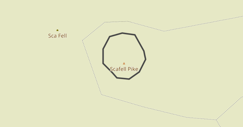
| How to show paths on a map? | Zoom in a bit and you can see what is happening:
The “Sca Fell” name is from the trig point, and the “Scafell Pike” name (which is obscured) and elevation (which isn’t) is from the peak. For “proper mountain-looking mountains” this side of Dover you probably want something like Errigal though… |
|
| Is this how gen Z works? They talk through hashtags right? |
At a guess, I’d say “markdown”. See https://kramdown.gettalong.org/quickref.html . |
|
| Reimagining the OSM User Profile | @MatthiasMatthias In what I wrote above I tried to suggest a way forward so that the diarist here can see the ideas described here realised. OSM does not have dozens of people with no ideas but lots of free time just waiting for people with ideas to come forward that they can implement. It actually has the reverse - lots of people with ideas about how things should work, but reletively few people in a position to implement them. To say otherwise is actually grossly unfair on people writing diary entries such as this - it encourages them to think that “software is written in powerpoint”**. In practice software (of any sort) gets written because someone somewhere wants to do it or because someone is paying them to do it - but the person doing the writing has to know how to write software. The good news is that with OSM everything you need to know is out in the open - for almost all OSM software the source is available and there are plenty of places where people who want to learn how to implement something can ask and get help about how to do it. ** I actually once did work for someone who seemed to think that - he once claimed that he had “demoed XYZ feature to a customer” when what he actually meant was created some slides of what it might look like. |
|
| Reimagining the OSM User Profile | (commenting here because this seems a more appropriate place https://github.com/openstreetmap/openstreetmap-website/issues/3785 ) This, and https://github.com/openstreetmap/openstreetmap-website/issues/3785, seem to be:
Normally, the way that development around OSM happens is that someone implements a small part of what they are suggesting, sometimes independently to the main site. That is then discussed with the people who look after the main site, because obviously there are lots of issues that they are aware of that “normal” people may not be (how it is integrated with the management software used, for example; legal issues such as GDPR, etc.). That discussion often takes the place of actual suggested code changes on github. How close are you to actually being able to contribute code - either as a working proof of concept project external to osm.org, or as suggested changes to the main website itself? Unfortunately, just providing pictures of what something might look like without any idea of how it could be implemented (or even if it is at all feasible) does not get us any closer to seeing your vision realised, but an implementation of something would. Do you have any actual development experience? I’m guessing based on github possibly not, and if that’s the case I’d suggest that in the short term you concentrate on how to deliver a small part of your vision yourself. You’ll no doubt need to learn some new tools and solve some problems on the way, but that’ll help you answer the questions that people are bound to ask (e.g. “how would you avoid X being a problem”). |
|
| Markdown Test | (obviously this is to some extent a rhetorical question to test markdown but) I suspect that the answer is that OpenStreetMap might be more “social” than you realise. For local groups, try looking on https://openstreetmap.community/ where you are. |