OpenStreetMap logo OpenStreetMap

Steven Vance's Diary

Recent diary entries

Originally posted on my blog Steven Can Plan.

It’s possible to use Overpass Turbo to extract any object from the OpenStreetMap “planet” and convert it from a GeoJSON or KML file to a shapefile for manipulation and analysis in GIS.

Say you want the subway lines for Mexico City, and you can’t find a GTFS file that you could convert to shapefile, and you can’t find the right files on Sistema de Transporte Colectivo’s website (I didn’t look for it).

Here’s how to extract the subway lines that are shown in OpenStreetMap and save them as a GIS shapefile.

This is my second tutorial to describe using Overpass Turbo. The first extracted places of worship in Cook County. I’ve also used Overpass Turbo to extract a map of campgrounds

Part 1: Extract free and open source data from OpenStreetMap

See full entry

Location: Doctores, Mexico City, Cuauhtémoc, Mexico City, 06720, Mexico

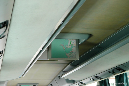
ALSINA bus from Seville to Cádiz uses OpenStreetMap

Posted by Steven Vance on 10 May 2014 in English. Last updated on 11 May 2014.

OSM on bus to Cadiz

I took a day trip on a coach bus from Seville to Cádiz on Wednesday to visit the beach while staying for a week in Seville. I was surprised near the end of the trip when the bus’s LCD screen started showing its current location using OpenStreetMap.

This bus has free wifi so it obviously has a cellular network connection and can determine its location as well as download the map tiles to display its current location.

It makes sense for the bus company to use OpenStreetMap: it is detailed and free, so the bus company doesn’t have to license the map from Google, Navteq, TomTom, Nokia, Bing, etc.

I think airlines should switch to using OpenStreetMap for their base layer when they show the plane’s position.

Photo originally posted on my Flickr.

It will be a couple days before the OpenCycleMap tiles are updated to reflect the new information. Campbell had previously been tagged but I tagged Clybourn (the diagonal street) yesterday.

The Chicago Bike Guide depends on directions from MapQuest Open Directions, a free service MapQuest offers that uses the OpenStreetMap database of streets. The service looks at how the streets are “tagged” to determine the relative bike-ability of a route between your current location and your inputted destination.

MapQuest Open Directions looks for the “cycleway” tag to see if the street has a bike lane that would increase a route’s bike-ability. If that tag doesn’t exist then it looks for the “bicycle” tag which has a value of “yes” (bicycles are allowed), “no” (bicycles are not allowed), or “designated” (bicycles are allowed and encouraged here).

See full entry

Location: North Center, Chicago, Lake View Township, Cook County, Illinois, United States

I’m adding Chicago-area campgrounds to the Chicago Bike Guide to entice new users and to espouse the enjoyment of medium-distance bike camping. The Chicago Bike Guide is available for Android and iOS.

I’m taking a systematic approach to finding all the publicly-owned campgrounds in the area by looking at primary sources.

First, though, I’ve used Overpass Turbo to create a list of all existing campgrounds in OpenStreetMap. You can see a gist of these places.

camp sites at Greene Valley forest preserve

The next method is to find out which campgrounds are operated by the county forest preserves, which are usually well-documented on their respective websites. Then I will look at state parks, operated by states’ respective Departments of Natural Resources (DNR). Next I will look at national parks and finally commercial campgrounds.

See full entry

Location: DuPage County, Illinois, United States

Richmond, Indiana on OpenCycleMap (before)

I visited Richmond, Indiana, in early August with my friend who grew up there. There isn’t much to do there, but there are a lot of neat places to bike to. Richmond had more features mapped than I expected, but I was happy to contribute via Pushpin and JOSM. With Pushpin OSM, an app for iOS, I added a couple of venues I visited, including Firehouse BBQ & Blues.

With JOSM, though, I wanted to add the city’s bike routes so they would appear in OpenCycleMap and could then be immediately embedded as a (somewhat) interactive map on the Bike Richmond website. I asked a city planner for a bike map and he gave me a GIS printout that showed the “recommended routes” (which are unsigned) and then he drew on the signed route that augment the recommended routes. The signed route essentially creates a loop.

See full entry

Location: Richmond, Wayne County, Indiana, 47374, United States