TomPar's Comments
| Changeset | When | Comment |
|---|---|---|
| 144076115 | over 1 year ago | FYI this newly created wiki page is a helpful reference for future cases like this:
|
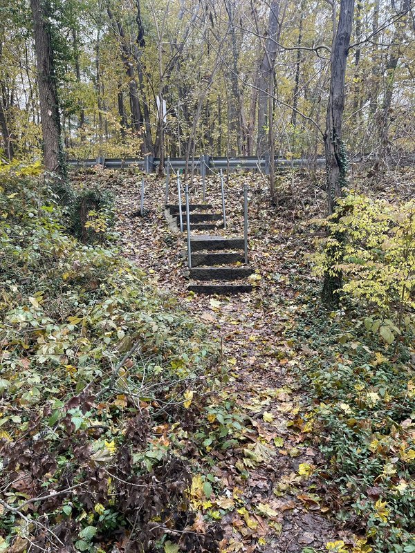
| 143089061 | over 1 year ago | There is a trail here. I just walked it today. There are even built steps down to it from Pine St.
|
| 144076115 | over 1 year ago | I walked this path today. There is a clear path. There are no "no trespassing" signs. There are no barriers. There are actually built steps, out of masonry blocks, from Pine Street to the trail. https://i.postimg.cc/50kRtPFs/IMG-8720.jpg If I didn't know about this thread, I would not have thought twice about mapping as a path on OSM. I think until the landowner puts some signage up or other indication on the ground the trail should be mapped. |
| 144076115 | over 1 year ago | The town recently acquired land just NNE and designated conservation land. See here: https://www.concordland.org/project/the-campaign-for-assabet-river-bluff/ This page, by the very well-respected local land trust, speaks of "A network of well-used neighborhood trails traverses the site and are now preserved and open to the public. The main trail along the top of the bluff affords lovely views of the river. This trail currently continues as an informal path on private property for 500 feet across four house lots and then meets the sidewalk at the Pine Street Bridge." I added the new conservation parcel and trails on it. The trails here, and on the private land are visible on lidar so people have been cutting through there for a long time. Streetview does not show "no trespassing" signs on Pine St. I hope to check out the new conservation land IRL soon. If there is nothing posted on the private land, then I believe the access tags for the path on private land should be at least "permissive". I saw the DWG ref number on the way. How does one view that? I'd like to see more information about what the landowner said. Thanks. See here too:
|
| 130768287 | almost 2 years ago | Hello. This was already an "area" because it was part of a multipolygon relation. Your changes were redundant to existing geometry definitions. Please refrain from deleting boundary lines. Are you not seeing the multipolygon relations in your editor of choice? Thanks.
|
| 120761978 | almost 2 years ago | I'm the one who created the original relation. Madiener, are you familiar with using multipolygons for delineating parcels? If not, please research this method. That is how this property and those adjacent were originally defined. I also noticed some other properties in MA that I had worked on were similarly broken. Please be careful. Thanks. |
| 133408244 | about 2 years ago | Thanks for the additional thoughts. And I agree, technically, with everything you said. It's not wrong per OSM norms, it's just getting to a broader OSM-based ecosystem issue as to how the data flows and is used by commercial mappers. For instance, in the popular GaiaGPS Topo layer that "track" is now displayed as prominently as other "tracks" nearby that one could drive an 18-wheeler down. The "fault" lies in the renderer. Out of the scope of OSM. It's an intractable issue the community has been grappling with forever. FWIW: this reality informs my own OSM mapping ethics. Because I know "path" or "track" will lose almost all additional tagging nuance outside of OSM, I don't tag things "track" or "path" unless it reaches a _much_ higher bar. So, it's not "wrong". It's just now the likelihood some mountain biker (or even a casual hiker) will be disappointed because the trek from Somerset Reservoir to Mount Snow is actually quite the semi-hardcore adventure involving getting bloodied legs from all the bushwhacking on the "track". |
| 133408244 | about 2 years ago | IMHO, DEM alone is not sufficient...especially to call something a "track". I could barely get through there pushing my bike. I've poured over a lot of DEM in the GMNF and there are many old "tracks" from many decades ago that are very grown over....never would you think you could get a vehicle through there... (some interesting stuff near MacIntyre for instance). |
| 133408244 | about 2 years ago | Calling the very overgrown "path" from Mt. Snow to Somerset Reservoir a "track" is quite a stretch IMHO. I was on this last summer. Was on my gravel bike and definitely had to hike-a-bike this. Have you been recently? |
| 117175466 | over 3 years ago | I only continue to push this "for fun", not that I care all that much but. I'd rather focus on the many "public parcels" yet to be fully mapped in OSM for instance. I think there is sometimes a tagging semantics nihilism that occurs with such debates...edge cases and a desire to be completely logically self-consistent results in tagging that is unintuitive. Yes, of course, it's not just strictly residents that can traverse "access=private", but it's VERY commonly understood that non-residents like those you pointed out can access the driveway for a relatively narrow set of purposes: walk up drive to return that lost dog? That's ok. Have a party in a stranger's driveway with 10 of your friends? Not so much. To make a ridiculous counter-argument: it's generally OK to make a "U" turn by briefly turning into someone's driveway and backing up...especially in a rural area. As the driver wasn't driving the 100m up the driveway to the "destination" "access=destination" does not properly capture all the legal/socially acceptable ways that the driveway can be used. Why can't "access=private" just be how it's presently defined in the wiki: "not to be used by the general public". A friend or delivery person is not "the general public". Granted, this is a bit ambiguous. But I'd argue for a project like OSM, it's better to have simpler, more intuitive user-friendly tagging than obtuse alternatives that are more "technically correct" but require researching threads on Slack to understand. Anyways...thanks for the discussion. |
| 117175466 | over 3 years ago | When you say "documentation", presumably you're not talking about the "access" wiki page. Looking at "destination": "Note that "access only for residents" is private". There is not much guidance here:
I can appreciate the wiki does not always reflect the latest community senmtiment. But IMHO, wiki documentation should be updated before mass changes like this. Especially as, in my experience, all elements like this I run into are basically 100% access=private. |
| 117175466 | over 3 years ago | Hello. What's the justification for converting driveways to access=desitnation? Are these not usually access=private for residential properties? |
| 117096437 | over 3 years ago | My point with the Acton trails reference was just another datapoint for a town that is using a custom Mapbox implementation. My Mapbox skills are very low, but here is a very quick edit of the default Mapbox Outdoors map to show the paths with pistes to look like the paths without pistes.
This is to just further drive my main point that valid OSM data should not be deleted because it doesn't suit your render needs. The render can/should be altered to suit your specific needs. |
| 117096437 | over 3 years ago | There is a way in Mapbox to hide the pistes format (by making the conditional formatting transparent) and just have it show up as a "path"...or whatever. It requires getting a bit more into the guts of the code...but it seems doable on my sample custom Mapbox map. Your explanation remains about the render, and not about the validity of the tagging. I'm not going to continue to push this...BUT, someone took the time to add those tags, they are valid tags, and you unilaterally removed them for your specific map publishing purposes without previous discussion. There is an online community of OSM mappers that you can leverage. In the future, I encourage you to reach out before making such mass edits...especially with valid tagging. BTW, Acton uses Mapbox too for their town trails:
I appreciate your time volunteering for the trails committee. We all want the same thing: accurate maps for the public. Please keep in mind your organization is not the only user of this data. Thanks. |
| 117096437 | over 3 years ago | Please consider that your issue is with the map render and not the validity of the tagging. Which mapping products are you referring to? I bet there's a map out there that renders "horse=yes" trails differently too. Can you explain how the nordic ski tagging is inaccurate? |
| 117023618 | over 3 years ago | Hello. This is not a valid edit. The "name" field should not be used as a composite of the common name and MIT building number. Please provide further justification why you think the building reference # should be in there. Thanks. |
| 117096437 | over 3 years ago | Hello. Why are you removing these nordic skiing tags? I personally wouldn't add them to such trails...but they are not "wrong". Please provide an explanation. Thanks. |
| 116712446 | over 3 years ago | I think the mapper was saying the wooded area as a whole is known as "Oleo Woods"...compared to the municipal-owned parcel "Oleo Woods Open Space". Perhaps confusing so good you removed it. FYI: I noticed the ways for "Oleo Woods Open Space" and adjacent "Woodman Open Space" were not aligned to the latest MassGIS parcel data so I just realigned. Are you with the city? Should the two areas still be drawn as separate? Or is the conservation committee (or whomever) planning to "combine" the parcels and rename? |
| 116682530 | over 3 years ago | Hello. Not quite sure what's going on here with this edit, but the map now shows a "bridge" between Plymouth and Provincetown. What was the reason for this changeset? Thanks. |
| 116626975 | over 3 years ago | Hello. Please consider using the tag "official_name" instead for this edit. I believe the original name before your edit is more appropriate per the spirit of "name" in wiki: osm.wiki/Key:name. On the website https://www.massaudubon.org/get-outdoors/wildlife-sanctuaries/drumlin-farm "Drumlin Farm Wildlife Sanctuary " is used...and I believe signage on the property uses this too without "Mass Audubon" prefix. Are you planning to prepend all properties with "Mass Audubon"? Also, was there a reason for removing the wikipedia/wikidata tags? Thanks and happy mapping... |