OpenStreetMap logo OpenStreetMap

Zverik's Diary

Recent diary entries

The 2016 Board Elections Statistics

Posted by Zverik on 23 January 2017 in English.

The OSMF Board elections happened a month ago, but only now I’ve got my hands on the anonymized ballots. Which means we are getting some statistics.

First, let’s look at numbers. By the 10th of November we had 457 members eligible to vote. That is much lower than the previous year, when we had around 500 eligible members. Still, that’s just a tiny fraction of active OpenStreetMap editors, so the room for improvement is huge. Other numbers have also dropped: 4 candidates instead of 11 in 2015, and 253 voters (55%) instead of 272 (~53%).

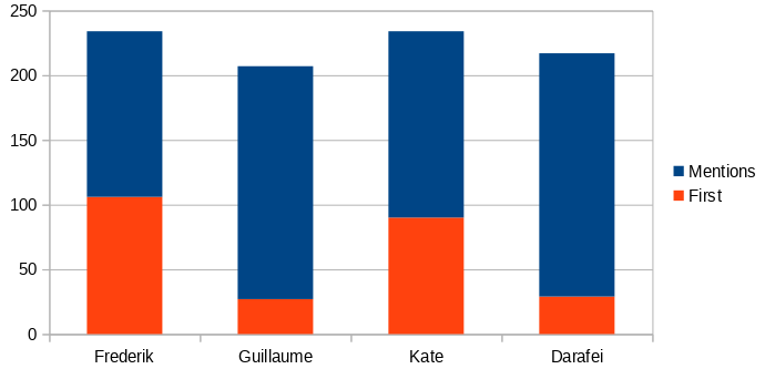
It was definitely the fastest and simplest of OSMF elections: with only four candidates, two of whom were running for re-election and other two much less known in the community, 77% of first choices were either Frederik or Kate. That is, Kate got three times as many first votes than the runner-up. I doubt there is a system in which the outcome of the voting would be different.

A chart for mentions and first places for each candidate

See full entry

POI Edits by Editor

Posted by Zverik on 29 December 2016 in English.

The editor usage stats wiki page has two useful tables for comparing editors: by number of users and by number of edits. And while MAPS.ME reach is clearly visible in the first one (alas, it hasn’t still surpassed iD in users), the second table has much lower numbers for the mobile editor. Which is reasonable: MAPS.ME does not allow editing geometry, thus a single user can make more edits in a day, than all MAPS.ME users in a month.

I was wondering if we could compare only the type of edits our mobile editor allows, that is, POI edits. And with daily replication diffs, I did:

Created and Modified POIs by Editor, total

This chart shows that while users of iD and JOSM editor create more points of interest than MAPS.ME users, it’s not by a large margin.

I noticed days when 10k or 20k new POIs were uploaded with JOSM, and wondered if the picture would change if we took median values for days of each month. That is, from a sorted array of numbers we would take the middle number. Turns out, not much.

See full entry

100 € for multiple social accounts in OSM

Posted by Zverik on 14 November 2016 in English. Last updated on 7 December 2016.

Last time it went pretty well, so let’s try another long-standing issue. Namely, #1274.

You can register or log in to the OpenStreetMap website using a social account: Facebook, GitHub, Google. The thing is, most of us have many social accounts, but you can only link one to your OSM profile. If you click a wrong button, you will have to either go back or register a new account. You cannot log in to your account using different social buttons.

For me, that is a problem. I would like to not remember which of the buttons I clicked when I tested the social login, and which of these is linked to my main OSM account. For that I would like a social accounts management in the settings page. Alas, I don’t have time and skills to add that, but I have a hope that somebody has. And for that I’m willing to pay a small grant: a hundred euro, like the last time.

The offer stands for two months: the pull request to openstreetmap-website should be submitted until 15th of January and merged until 15th of February. Right after merging I will transfer 100 € to any given credit card or bank account.

Tagged and Untagged Nodes

Posted by Zverik on 18 October 2016 in English.

I’ve just counted some statistics on a planet file from 14th of October. Here it is:

A table with node statistics

This table shows a number of nodes, both tagged and untagged, that are referenced by ways and relations. You can see that nearly 97% of 3.5 billion nodes are untagged, and most of these — 88% — are part of exactly one way or relation. Like, when you trace a building, you add four untagged nodes that are part of that closed way.

98.4% of all nodes are part of something, but only 12% (424 million) have two or more parent objects. This could help with designing a data storage for nodes.

There are equal amount of tagged nodes that are not part of anything, and part of an element. Interesting are these 9 million tagged nodes that are part of two or more ways. The taginfo says there are 2.5 million crossings and 860 thousand traffic signals, so that’s a ⅓ of that.

See full entry

Short history of name editing in MAPS.ME

Posted by Zverik on 11 October 2016 in English.

Many mappers agree that simple and accessible editors are hazardous: the simpler editor is, the easier it is for a horde of newbies to submit wrong data. This was a main argument against Potlatch, and then iD. Now MAPS.ME built-in editor allows for changing tags and adding nodes with just a few clicks for any of our tens of millions of users. Which of course has led to a number of questionable edits.

Screenshot of the first editor with name field

The first field in any place card is name. When we released the editor in April, it was a single field for editing the “name” tag. You changed a name — the new tag value was uploaded to the map.

Complaints started coming almost immediately. Turns out, some tourists were renaming attractions to their language for easier navigation. If you look at the Questionable Edits wiki page at the time, you’ll see that names in wrong languages are the most worrying kind of edits.

See full entry

100€ for a subscription to diary comments

Posted by Zverik on 29 September 2016 in English. Last updated on 30 September 2016.

Okay, I’ve got tired of this UI, and I’m swamped with other tasks, but there is some money left from my travel to SotM. So I am announcing a grant: 100€ for a merged pull request allowing people to subscribe to comments in OSM user diaries. (NB: 300€ now, thanks to Stereo and Mikel.)

There should be a checked by default checkbox near the “Save” button (“Receive notifications about further comments”), and a button to subscribe/unsubscribe. All notifications should go to e-mail, much like changeset comments now.

When you have your pull request merged, I’ll transfer that money to your card or bank account. And of course I’ll publish a big thank you :)

The offer is not indefinite: the PR must be submitted until the 1st of November and merged before the 1st of December. And yes, there might be a competition, in that case OWG will decide the winner by merging a pull request.

OSM Stars from wiki

This Sunday, we will meet the nominees for the first OSM Award and learn who gained the most votes in each of the six categories, including Mapping and Blogging. 650 mappers have already voted, and if you have not, please head to the awards website and make your choices. All you need is an OpenStreetMap account.

The voting closes on the morning of September 22nd, when the Brussels Maptember begins with two great conferences: HOT Summit and FOSS4G.be. After that we will dive into OSM topics at the State of the Map, and on Sunday, before lightning talks and workshops, we will know the winners.

But for now, there are still ties in some categories, and your vote can decide who will get the award. Do vote now and meet us at the State of the Map!

MAPS.ME is now an editor

Posted by Zverik on 5 April 2016 in English. Last updated on 6 April 2016.

Which popular editors do we have now? According to statistics, three of these: iD, JOSM and Potlatch 2. The next four editors are mobile: Go Map, OsmAnd, Vespucci and Pushpin each have a thousand of users. Today there is another one, which now has less than a hundred users, but aims to go for the first place: MAPS.ME.

As you might know, MAPS.ME is a popular app for using OpenStreetMap data on a phone or a tablet. It has geocoding, routing (using OSRM engine), bookmarks and 3d-buildings. It runs both on Android and iOS devices, and it is very fast. Obviously it works offline: you just have to download some countries. Besides speed, MAPS.ME is known for simplicity: even I can understand which buttons to press, without examining every control and menu item first.

Just now we have released the first major update this year. It has better geocoding (and reverse geocoding), smaller regions (no bigger than 70 MB, most are below 50) and, the most important change, now it can edit the map! In most POI cards (click on a POI and get one) there are two new options: «Edit place» and «Report a problem». The first one opens a simple (as in, easy to understand) editor for relevant fields: name, address, opening hours. The second one is for leaving OSM notes. Also there is an «Add a place» option on the menu. So yes, it’s an editor.

See full entry

Почему-то информация была только на форуме, но на ближайшие дни, если хочется потренироваться в картировании города, который ещё не так надоел, как ваш собственный, загляните в тему http://forum.openstreetmap.org/viewtopic.php?id=53769

Vote for me, it would be fun

Posted by Zverik on 26 November 2015 in English.

I am Ilya Zverev, a.k.a. Zverik, currently living in Russia. I’ve nominated myself to the OSMF Board, and now I have supposed to write a manifesto, touching on diversity, transparency and other serious topics. But the thing is, I’ve read all manifestos for past three years, and all of them (except Frederik’s) are boring and didn’t affect anything. So what if I show support for transparency — would it help? Nearly all candidates supported it, and look how verbose Board minutes are (they aren’t).

Do you know what the Board is working on? I don’t, and I read the minutes. There are two options: either the Board discusses a lot of things on their private mailing list, or they actually are working only on topics spotted in minutes. Both of these are not good: I am a member of OSMF, and I expect to know what’s in store for OpenStreetMap. I hope it would change, and maybe I could help it — but after Frederik’s revelations, I am not sure. I’ll try.

I support diversity. The Russian community is severely under-represented in OpenStreetMap, despite being the fourth (occasionally the third) biggest in the project. Though I don’t like needless «regionalizing» of some aspects, e.g. tagging. Obviously, we should promote OSM in more countries, though I don’t see how it is the Board’s task. Last year I learned what gender diversity actually means, how inequality is enforced by nearly every aspect of most cultures, and that IT has it worst. But also I was taught that, as a man, I can do nothing about it, other than properly teach my daughters. So I have nothing to offer on the topic of diversity.

See full entry

Daily MAPS.ME data updates

Posted by Zverik on 25 August 2015 in English. Last updated on 15 April 2019.

If you are not yet using MAPS.ME, you are missing out :) The most frequent complaint from the mappers was that official maps in that application get updated only once a month, along with new releases. I usually map stuff the day before I’m going out, so this update cycle does not suit me. And since I work for them now, I can fix this.

Since this month, there are daily updated map files for MAPS.ME. To install downloaded files on Android, find MapsWithMe directory on your device (you can check “Settings → Map storage” in the app), and put new files there. You should delete old maps and directories with same names (the latter is to clear caches). And probably restart the app. On iPhone and iPad, just use iTunes: find and open MAPS.ME application, delete old maps, upload new.

Maps are published every day at around 5am UTC. Mwm files are maps, routing files are needed for car routing (pedestrian routing doesn’t need them). In a couple of days a new version would be released, and it will be required for daily maps to function.

These files are not official. The application may behave strangely (there will be notifications about outdated maps), data may be broken (it’s OSM, it is always broken), and your application may crash. If you encounter anything strange, you can clean the MapsWithMe directory and/or move the app from SD to the device memory, which must fix most bugs. Daily maps are my initiative, and MAPS.ME company is in no way responsible for these. Of course, I’m ready to answer any questions.

Update: the original URL is not updated, the new weekly-built maps are here. Subscribe to this issue for updates.

Is it the moment for OpenStreetMap?

Posted by Zverik on 28 April 2015 in English.

Surely now is the moment for OpenStreetMap to accelerate adoption, usage and uptake? But why hasn’t this already happened? Why hasn’t the geospatial world run lovingly into OSM’s arms?

Gary Gale published an interesting article on removing SA clause from our license (actually, the major part was about business-friendly face, but you know the principle: want it? go do it). We’ve heard it before, from Mapbox. As Richard points out, that won’t happen any time soon, because there is clearly less than 2/3 of active contributors supporting the idea.

And these opinions strike me as lacking an understanding of OpenStreetMap project. Are we mapping for PNDs? Yes. Are we mapping for commercial companies? Of course. Would we like a thousand more commercial users promoting OSM by simply using it? Yes, go ahead. What? They cannot do that right now?

Well, we can wait. That what distinguishes us from other map data providers: we can really wait. OpenStreetMap is slow, but unstoppable. Mapbox and other businesses have immediate tasks, and for that they need a fast reaction from OSM. But OSM isn’t fast. The last license change took 3 years. That’s just a bit less than Mapbox has existed. Some think that because we make maps for crisis areas so fast, we are very responsive – but we are not. And it is good.

See full entry

Steve's Answers

Posted by Zverik on 15 January 2015 in English.

Two weeks ago Steve Coast held an AmA (Ask Me Anything) on Reddit. I’ve selected and rearranged some of his answers for this post, since he rarely expresses his point of view on lists or anywhere else.

Also, he agreed to participate in next week’s Russian OSM Radio (in English, of course). You can submit your questions during the broadcast (22nd of January, 20:00-21:00 UTC) on #osm-ru IRC channel.

mr_gila: What inspired you to start up OSM?

There’s a few different answers to that question. On one level, it was just kind of obvious. Back then, in 2004, Wikipedia was hot new technology and the wiki idea in general was spreading. Why not apply it to maps?

On another level, I had an old laptop with Debian Linux on it and a USB GPS device. I tried to use some mapping software but there were no maps. So why not make them?

On another level, the maps that were available in the UK and Europe tended to be very proprietary and expensive. So why not open them up?

On another level, I was young and naive.

Let’s not forget though that OSM is now many, many people from all over the world. It wouldn’t have worked if I hadn’t convinced a lot of people to join in and help.

mapsandmapsandmaps: How did you find your time studying at UCL, and how much of an impact do you think this lead into you founding OSM? Does it feel strange that it has become a big topic of academic research with people like Muki Haklay writing papers about it?

UCL. I was working in a couple of PhD research labs and not paying much attention to studies. That mean I had the time and resources (computers with direct access to the internet, no NAT!) to go do OSM and other things.

Muki was in one of those research labs (as was Paul Torrens, Martin Dodge, Sean Gorman and others), so it’s not entirely strange.

ManAboutCouch: Half-jokingly, how has OSM managed to get this far without a properly defined Polygon feature type?

See full entry

Calling mappers from Porto

Posted by Zverik on 5 January 2015 in English. Last updated on 8 January 2015.

Hi everyone, I’ll be visiting Porto in two days. Portugal is great, not as cold as Saint-Petersburg. We’ve already been to Lisboa, from where we recorded a holiday OSM podcast: English parts start at 2:00:30 (featuring Manuel Hohmann, Thomas “malenki” and Jerry Clough) and 3:01:15 (with Ian Lopez). The next issue will be recorded on 8th, 20:00-21:00 WET, and I very much hope to talk with a local, portugese mapper. Maybe even face to face, though usually I use Skype or Mumble.

So, if you map Portugal, or live in Portugal, or know someone from Portugal — contact me please. Also, I’m up for a osmers meeting in a cafe near Santo Ildefonso on 7th or 8th. I’m Ilya, my phone (for sms only) is +7 921 583-12-91.

update: radio recording today, 8th of January

Three questions

Posted by Zverik on 26 December 2014 in English.

We in Russia have a weekly podcast recorded live: OSM Radio (looks like RadioOSM, I know). Every Thursday we go online, discuss OpenStreetMap news and interview guests, either from OSM community or from OSM-related companies (Sputnik, Maps.me, OsmAnd, NextGIS etc).

The next broadcast will be on the 1st of January. Because of the holiday, that won’t be an ordinary podcast, but an “open mic” event. From 17:00 to 21:00 UTC we’ll be receiving calls from OSM members (and making calls ourselves), and will ask three questions:

  • What was the most cool or satisfying thing you did in OSM last year?
  • What was the biggest event for you in OSM in 2014?
  • What do you expect of OpenStreetMap in 2015?

On that evening we expect to bring the community together and to make them hear each other, to really feel like a group united by the common goal. And I think it would be great to have English-speaking OSM members on air as well. Probably in the second half of the program. We are open till the last visitor, so if there are many osmers, we’ll finish later. If you want to participate, call me by skype (zverikk) on the 1st after 19:00 UTC, or mail me (ilya@zverev.info) your skype id, so I will call you myself. Mumble server is also available, mail me for its address. Let’s make it an event to remember.

What I want

Posted by Zverik on 12 November 2014 in English. Last updated on 13 November 2014.

Hi. I often drop hints about what our project misses, and now want to talk some bit more about a part I’m interested in. Since I joined OpenStreetMap, I have been interested in geodata collecting methods. I quickly grasped walking papers, put my GPS and camera to use, and struggled with georeferencing audio recordings. OSM allows for many types of sources, and in past years a lot were invented. But alas, not much in last years.

Walking papers (or field papers) are still produced from tiles. Fieldpapers.org, the “modern” service for generating atlases, is more than two years old and is a slight update to older walking-papers.org, built in 2009. It stiches tiles and produces a PDF file. You have no control over map style, you can’t even use your own tiles. “Toner” style, which is the best option, are updated infrequently: you might have to wait a week before traced buildings appear on it. And some of them still won’t, since it’s hard to grasp how it works and why it hides some features unpredictably. Finally, pages of an atlas will be oriented by cardinal directions, in a grid with 90° angles. Of course, not many towns have such proper road network, so you will have to choose smaller scale, with less effective area for mapping.

I think I can fix this. It is easy, really: most of building blocks for a proper solution are already invented. First, an interactive map, on which you place rectangles for pages. Arbitrarily, not neccessary in a grid. Maybe draw some lines, which would be “pie segments”: instead of using MS Paint for making a pie, use some advanced technology. Maybe integrate it with MapCraft. So, a bunch of rectangles on a map. Not 90°-aligned: rotate them as you like. Align with road network, with streams etc, so areas for filling in take as much space as possible, and scale is biggest you can get. When done, just save your work and close the website. Go trace some buildings and tracks.

See full entry

OSMF Board voting extra statistics

Posted by Zverik on 9 November 2014 in English.

Richard is now counting some stats on anonymous ballots from the Board voting, and he persuaded me to publish some other, more complex stats I did on that Saturday. So, here comes.

Basic counting

Out of 219 ballots…

  • 79 (36%) have all 8 candidates ranked
  • 56 (26%) have 3 candidates
  • 23 (11%) have 4 candidates

Richard makes a smart assumption that some people didn’t quite understand that one can submit any number of candidates, not one, not 3 (for number of seats) and not all 8. I submitted 4 candidates, because I had strong preference for Board members, and I believe that’s the case for most of 3/4 votes. And people who filled all 8 positions maybe are not happy with a tiny chance their vote will be burned otherwise.

Every candidate has been listed at each of 8 positions in ballots (that is, there is no candidate that haven’t been assigned e.g. #6 in at least one ballot).

For ballots with less than 8 positions, some of the candidates were not mentioned. Let’s count number of ballots for a candidate, where he/she is not included:

  • 102 (46.6%) — Steve Coast
  • 93 (42.5%) — Ethan Nelson
  • 80 (36.5%) — Randy Meech
  • 75 (34.2%) — Marek Strassenburg-Kleciak
  • 73 (33.3%) — Paul Norman
  • 64 (29.2%) — Peter Barth
  • 54 (24.7%) — Kathleen Danielson
  • 39 (17.8%) — Frederik Ramm

So, nearly half of voters skipped Steve (I wonder why) and Ethan (probably because he is less known than others). Frederik and Kathleen wrote a lot of good, thought-provoking posts in osmf-talk, so I hope that’s why everybody were voting for them.

Second places

We know Frederik Ramm got 78 first-rank votes, and 23 of them were distributed among other candidates. Whom?

  • 27 (35%) have chosen Peter Barth as the second candidate, so he got 8 of these extra votes
  • 19 (24%) have chosen Paul Norman, so he got 5.6 votes

(The rest was skipped because numbers are too small). Some of those who gave the first preference to other candidates had very strong preferences for the second place:

See full entry

An alternative to /export

Posted by Zverik on 28 June 2014 in English.

Have you ever printed a map? Clicked a hundred times on “Export” button on osm.org? Installed mapnik or maperitive and spent days configuring a database and customizing a style? Did you wish for a simple web service that lets you select a bounding box and produces a hi-dpi raster or vector image? Well, there is one now. It is called Get Veloroad, for a style it was created for.

On the side panel you choose paper format and margins, add a GPX trace if needed, select style (“veloroad” and “osm.org” are available), image format, and press “Submit”. If the server is not overloaded, you’ll get your image in a minute, in glorious 300 dpi. SVG files are postprocessed, so you can easily move labels as a whole, instead of separate letters (the most annoying trait of mapnik-generated maps).

Alas, my server cannot fit all the planet, so there are only Baltic countries and parts of Russia and Finland. Everything is open-sourced though, so I hope soon we’ll see a worldwide service for producing high-resolution images.

Nik4 gets smarter every day

Posted by Zverik on 4 June 2014 in English.

Since the release of Nik4 some bugs were fixed: namely, scale (-s 10000 = 1:10000) is applied correctly, georeferencing parameters were corrected, and very large tiled maps (bigger than 16k×16k, mapnik’s limit on images) are created without errors and are properly georeferenced (you can load them in QGIS without any extra work).

Now the version is 1.4, and there are features to make producing maps more fun. For example, you don’t need to extract latitude and longitude to get an image of an area you see at osm.org: just run

nik4.py --url http://www.openstreetmap.org/#map=16/55.9865/37.2160 osm.xml screenshot.png

and you’ll get 1280×1024 map near that point. Like a screenshot, but more flexible. Users from USA can now specify US Letter paper format (--paper letter, or shorter -a l). Style XML can be streamed from stdin, and the resulting image can be streamed to stdout.

Dimensions are not bound to width and height now: they are swapped automatically to better fit given bounding box. And you can set one of dimensions to 0 to calculate it from bbox. See this chapter of documentation for examples.

Finally, styles can now have variable parameters. If there is ${name:default} sequence anywhere in style XML, with --vars name=value argument you can replace it with any value, or with the default value, if name is omitted. This allows for printing different routes with the same style, or exporting a map in many languages.

To update Nik4 with pip, run pip uninstall nik4; pip install nik4. For calculating bbox for a given route, you can use this page.