OpenStreetMap logo OpenStreetMap

Zverik's Diary

Recent diary entries

OpenStreetMap Awards 2025

Posted by Zverik on 20 July 2025 in English.

As you might know, we’re having OpenStreetMap Awards this year! Finally, after many skipped years, we will have the honour and the joy to recognize people and teams who have made an impact on OSM, whether it’s by mapping, writing, or coding!

The process is open, and the same as the last time: first we gather all the nominees we can think of, then some groups of notable OSM members will choose a few from those who feel to be the most notable, and after that — an open community voting to choose one for each category. And the categories are:

  • Core Systems Award — for building or maintaining an core project.
  • Innovation Award — for making something new.
  • Influential Writing Award — for blog posts, tutorials and documentation.
  • Greatness in Mapping Award — for tireless mapping!
  • Expanding the Community Award — for finding us more members.
  • Team Achievement Award — awarded to companies and groups.
  • Ulf Möller Memorial Award — like a lifetime archievement award for individuals.

Note that only achievements made or announced in 2024 or before April 1st, 2025 are eligible.

And right now, I need you help. The deadline for submitting nominees is looming, and we’ve got too few. Each category needs at least twenty to make sense, and for some, we got like two.

This needs some archive work. Like, open WeeklyOSM or big community discussions (before April 1st), and add people, projects, and teams you think made the OSM in general slightly better.

And submit them to https://awards.openstreetmap.org/

(Yes, we’ve got the official domain, thanks to Grant!)

What's New In Every Door 5

Posted by Zverik on 29 May 2024 in English.

I make Every Door to be the best on-the-ground surveying app. Its focus has always been shops and amenities, but it’s summer now! Ride a bike outside a city, take a scenic route. And bring Every Door with you, because it is ready for outdoor adventures.

Today version 5.1 has been published to both major app stores, and soon on the rest. Here’s what the app learned to do in May:

Every Door app with scribbles drawn on top of a satellite imagery

We have always had map notes, but now you can draw on the map! Saw an unmapped track road or a stream? Open the 4th mode in Every Door, unlock the scribble mode, choose the type and draw with your finger. This goes to a separate database, which you can then use in JOSM or Rapid.

Read this wiki page to learn how it works and how to add the layer to your editor.

See full entry

So the SotM EU just ended (guys from UK asked to call it “Europe”, not “EU”). We had a lot of talks, hundred people from the States and Belgium, met many friends. And also learned a bit more about Overture Maps. Nothing new since my Shtosm post, but updates my post about donating money. This is a rough DeepL translation of this and this telegram posts.

Marc’s Address

First, a simple one. Overture is not OpenStreetMap. Marc started by saying that the target audience for Overture Maps is developers. Just as Ballmer once chanted: developers, developers! And he’s right: Overture makes working with data much easier for developers. The data is collected, cleaned, in a convenient format, take it and build it into the product.

So the audience is product developers. Who know little about geo, but a lot about building products. As I wrote in the reddit about VLC, there are developers and there are developers. The audience here are opensource developers: god knows how to organize them. They are not the TA of Overture. They’re doing OSM. So when Mark encourages developers to use (and of course improve) Overture here, he’s kind of leading developers away from OSM. And that’s the first thing that was a bit tone deaf in his presentation.

The second is what I detailed in my question after the talk. That is, I’ve written before that Overture is an awesome wrapper to OSM. It sells data, it sells an idea, it does all the things we don’t want to do. But at the same time, the attitude towards Overture and the community was: you’re doing a great job, all these maps are very good, the tools you’ve written are great too, keep it up.

See full entry

Moving Python scripts to OAuth2

Posted by Zverik on 14 October 2023 in English.

Spent today writing a new Python library. Super useful if you are making command-line OSM processing scripts:

https://github.com/Zverik/cli-oauth2

With it you add OAuth2 authentication in just one line of code (well, 3-4 after PEP8).

auth = OpenStreetMapAuth(
    client_id, client_secret, ['read_prefs', 'write_api']
).auth_server(token_test=lambda s: s.get('user/details'))

user_name = auth.get('user/details.json').json()['user']['display_name']

This line starts a local web server, opens OSM OAuth page, catches the redirect, stores the token on disk, and returns a requests session that also prepends the API endpoint to its parameter.

Not very secure — but it doesn’t need to be. One drawback is when publishing sources to github, you would need to publish your client credentials as well. Or just read then from a config file, idk.

Already updated my Simple Revert and OSM to Sandbox scripts to use it. Hope it helps!

SotM Baltics 2023 logo

It’s that time again: we are ready to announce the third Baltics-located conference on OpenStreetMap and everything around it! Just like three years ago, we are joining the BalticGIT org team to have an opportunity to gather everyone interested in open data and open tools to present their work, meet other mappers and developers, and spend two days in a beautiful city on a super wide river.

Mark the date: 18-19 May (that’s Thursday and Friday!) in Riga, Latvia.

See the website for details.

The RIX airport is a home base to AirBaltic which has flights from like a hundred locations around the world. It’s really easy and affordable to come. So, we would be delighted to meet you there!

We are opening the call for papers. Please submit your topics, and we (me, that is) will contact you. We understand it’s just three months, but again, this is an OSM event, where there are new things every month :)

Registration will open a bit later, which we will also announce.

How to use Every Door

Posted by Zverik on 14 September 2022 in English.

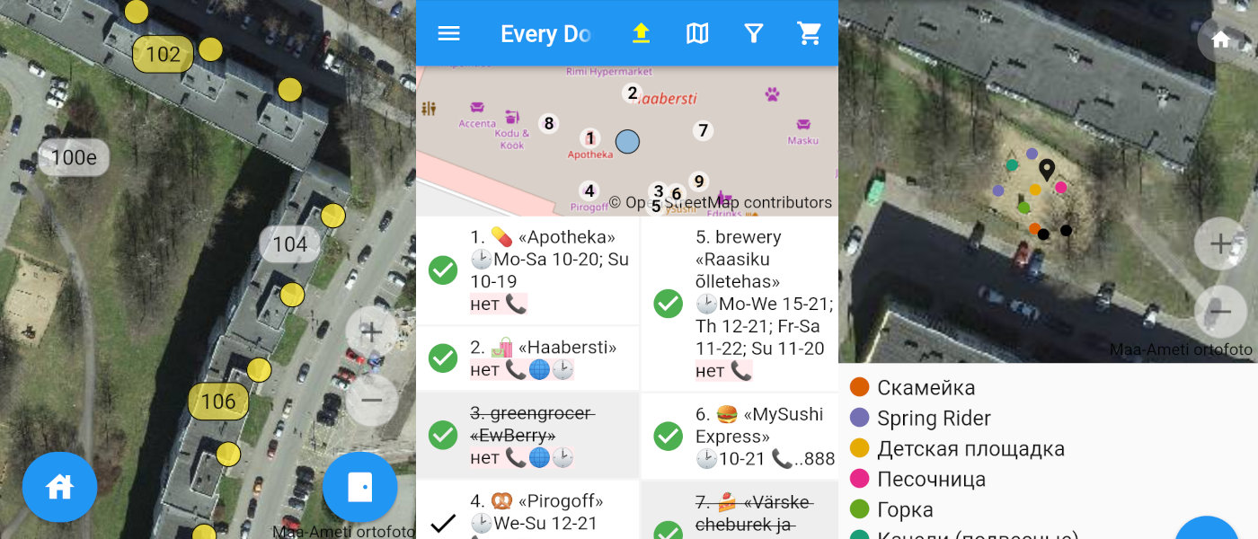
How Every Door looks while mapping a mall

This week I’ve released the 2.0 version of Every Door, which irons out most of the inconveniences found within a month after its official release. Yes, the editor has been officially released, just a few days before two talks on it at SotM and FOSS4G (recordings pending). You should download the editor for your Android or iOS smartphone right now!

I absolutely love the experience it gives me. It has revived my love for plain mapping, going out and collecting things to put on the map. Pascal’s HDYC shows my mapping days went from 29 last year to over 120 this year. That’s because I again look around for unmapped things while outside, and making an edit no longer requires navigating a map on a small phone screen, or making scribbles to open JOSM later at home.

See full entry

Happy ODbL Planet Anniversary!

Posted by Zverik on 12 September 2022 in English.

Dar es-Salaam in 2012 and 2022

Ten years ago on this day we changed the license for our data to ODbL, Open Database License 1.0. That was the final action of the lengthy relicensing process, which followed an exciting show of redacting and remapping the planet.

In July 2012 we started every day with watching the redaction progress map, discussing how the redaction bot devoured our precious map data, and making memes on the way.

After the bot finished its work, we started remapping everything we had lost. Poland and Australia were particularly broken, but most other countries had their losses. Alas we could not make everybody agree to the new contributor’s terms, so some mapping had to be done twice. But the work went better than expected, and it was then when we felt that the community is more important than the map, and that OSM can survive the loss of the latter.

See full entry

Regarding the data model changes

Posted by Zverik on 3 September 2022 in English.

I thought for quite a few days on the Jochen’s study for the OSM data model, and I’ve no idea on whether it’s good or bad or how to improve it. The process feels pretty straightforward to me.

But that’s the issue. It’s not impossible. To fix OSM data issues, changing the data model is not important. Frankly, I don’t have anything to add to my 2019 talk at Heidelberg. It was a reply to Jochen’s and Andy’s musings on API 0.7 back then, and it is still now.

Don't miss State of the Map 2022!

Posted by Zverik on 14 August 2022 in English.

I know, Florence is too far away, and tickets are worth a fortune. I hesitated for weeks before shelling out 800 € for a flight and a hotel. That’s too much even for me, so I totally understand if you could not make it this year.

Thank gods for the Internet though! We are continuing with an option of virtual participation in SotM. Traditionally that have meant watching talks online and occasionally making people at the venue read your questions out loud. Not too fun when you have to concentrate on events happening thousands of kilometers away.

BUUUT this year we trying something different as well. First, passive participation: few people at the conference (or just me, we’ll see how it goes) would post photos and announcements and general impressions on everything going at and around the conference. It’s a way to get a glimpse at the experience of actually being there. I have done it in Russian for every SotM and FOSS4G and FOSDEM since 2016, and now I thought it might fit well into the virtual attendee package.

Also, active participation: record a video introduction of yourself and put it into the library of introductions. That way you can listen to people who attend the conference, either physically or virtually, and start a conversation with any of them. It is a magic tool that helps learn something about a person before approaching them: might help when you have an introvert’s anxiety (I should know!). And generally it’s fun: it highlights that a conference is not so much about talks and dinners, but about people first and foremost.

So, do buy a Venueless ticket at https://pretix.eu/osmf/SotM2022/ and join us: yes, you won’t be able to shake any hands or split a beer, but with a very little effort you can be a part of the conference.

Edit tags directly from openstreetmap.org

Posted by Zverik on 21 July 2022 in English. Last updated on 23 July 2022.

After my last State of the Map talk, some asked me where’s that “Edit Tags” button on the osm.org website, to quickly fix any tags without launching Level0? Of course there wasn’t one: I just quickly made up a text area with Firefox developer tools. But the idea was there.

Now I’m proud to show you that the button works, with a series of changesets to prove it. Alas, not in the website itself: to enable it, you must install a browser extension. Get yours for Firefox or for Chrome. After installing, open the iD editor once, and then look at any object page on osm.org.

This extension is a hack. It uses some undocumented things and will break when something changes in the code. Like, you need to first open iD editor for the authentication to work. If you don’t see the “Edit Tags” link, refresh the page. It is flimsy, but you can edit the map with it.

See full entry

New mobile editor: Every Door

Posted by Zverik on 11 May 2022 in English.

Three screenshots of the editor

Today I’m proud to present my new OpenStreetMap editor. It’s called Every Door and works on both iPhones and Androids. I shared the idea last Summer at a State of the Map, but started writing just late October. In the last month and a half thirty people made ten thousand edits with the editor and helped make it much better. Now I’m launching the open testing.

The official website has links to TestFlight and Google Play, a short video, and a FAQ.

I’ve got just one feeling: at long last. One way or another I was suggesting something like that for OSM since 2013. Made a failed attempt with OpenSurveyor. Watched with hope for big company projects with paid developers — but all these have disappeared. In this time we’ve got one amazing StreetComplete, which I like a lot, although it’s not for me.

See full entry

Please Automate

Posted by Zverik on 4 July 2021 in English.

There are multiple mapping tasks in OpenStreetMap that people still have to do old-style, like we did in 2010. But with current technology and with current funding of OSM research, these can be automated, improving mapping quality over the world.

If you work on OSM-related projects for a company, like in Facebook or Apple, please ask your manager if they can spare your time on projects useful for the community. For example:

  1. Imagery alignment! People from the US and Western Europe won’t understand, but in most parts of the world, imagery is offset up to hundreds of meters. Mappers need to shift it to start mapping, otherwise different people would map with different offsets.

    We have plugins for automatically tracing roads, buildings and rivers. Why not create a button for JOSM and iD that looks at GPS traces (rasterized or not) and finds the best offset for an imagery layer?

  2. okay I had just that one idea and struggle to come up with more

  3. please share your ideas in comments