alexkemp's Comments
| Post | When | Comment |
|---|---|---|
| Adding a Preview JPG + crop-marks for printing | Hi @Rovastar
Well, so far I’ve had to learn about SVG1.1, SVG1.2, SVG2.0, Inkscape, GitHub & git, Bleed & crop-marks, printing from PDFs, pdfunite, unix2dos - and all without a scap of formal education in these things. Somehow I found myself avoiding updating any of the source PNGs for the leaflets during that process. And yes, it is more than a few years out of date. I would be most happy to accept donations from anybody of replacements/alternatives for any of the PNGs, but particularly: For my own situation (I live in Nottingham) I thought that a map of the heart of Nottingham would be suitable to replace For the |
|
| Update to OSM Promotional Leaflets due to Padding errors | Hi @zarl Inkscape has an option during the Save As…(PDF) process to add bleed to the PDF. It also auto-saves the PDF in PDF/X, adding font glyphs to the PDF. There also appears to be options to add a colour-profile, though I never explored that. I think that the padding issues came about due to a combo of:
The bottom line is that the printer I used was able to use the PDF to produce a print accurate to the drawing. |
|
| Amour Nyalusi | We cannot read your hard-disk. Upload the file to a host-site then use the Markdown for an image and we will be able to see the picture. Also, please remove the nonsense-letters above/below your hard-disk location. Thank you. |
|
| parking handicapés | Howdy @Laurent (sorry for using English) You will find help at osm.wiki/Tag:amenity%3Dparking . Near the bottom of the table is HTH |
|
| Investigating the unusual coordinated member signups close to the OpenStreetMap foundation's election |
Ask yourself a simple question: I would suggest that the answer is that you want all those that govern what & how OSM does what it does should have OSM’s best interests at heart. If you agree with this, then the next question becomes: “Is there a way to measure whether a person has OSM’s best interests at heart?”. The answer is “Yes there is”. If they want OSM to succeed, then they go out and do some mapping. If they do NOT map for OSM it does not mean that they hate OSM. It just means that they do not like mapping, and therefore are (at best) indifferent to OSM. Now, I don’t want folks that are indifferent to OSM on the OSMF Board. I want folks that are committed to OSM. And if they are committed to OSM then they will, of their own desire, go out & do a little mapping each month (at the very least). Finally, if they are NOT committed to OSM and they are on the OSMF Board will they please go off and do something else that they are committed to because, frankly, we don’t want them here. |
|
| Investigating the unusual coordinated member signups close to the OpenStreetMap foundation's election | Hi rorym 🏳️🌈
First, let’s point out that this is one option promoted by the OSMF Membership Working Group (MWG) in their PDF as part of a suite of actions to try to stop future influence campaigns from rendering OSMF elections unfair and/or distorted and/or utterly corrupted. Second, yes indeed, agree totally. For that reason I assume (and sincerely hope) that rate-limiting is normal on the OSM servers to prevent classic bot-spam activity. I dealt with this on a daily (hourly!) basis 15 years ago when I ran a website + forum on an internet server. It is reasonably trivial to stop bots by this method (they always run as fast as they can) although I found that the SEs can tend to also mimic bots as they scrape the site, which then leads to difficult decisions on whether to white-list those SEs. Third, if the premise of active, verified mappers is accepted, then it becomes necessary to compile a list of bots to form a further blacklist to prevent signups. I’ve actually advocated this before by pointing to SFS as an open-source compiler of sources of both bot- and human-spam which has proven itself as both safe and successful in stopping such malign behaviour. |
|
| Investigating the unusual coordinated member signups close to the OpenStreetMap foundation's election | These are the options that (it seems to me) MUST be adopted:
The last one, in particular, seems vital. Why on earth non-mappers, or those that mapped a little then gave it up, are allowed to be on the Board is beyond me. My extra suggestions are:
|
|
| Markdown vs Kramdown | @mmd: PS |
|
| Markdown vs Kramdown | It is one of my most common comments. This was the latest (author fixed it very quickly). |
|
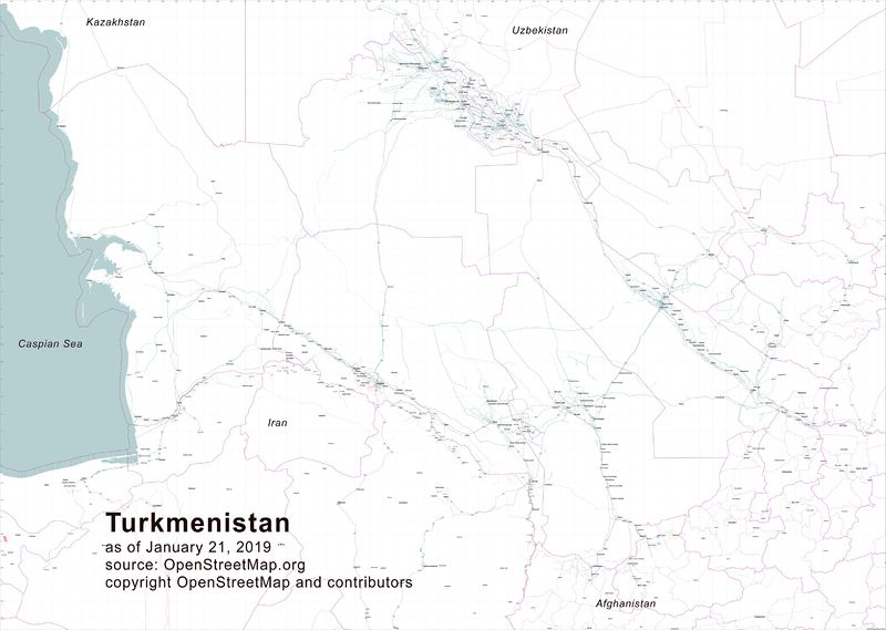
| Highway Atlas of Turkmenistan | I would have suggested a different route if you are using Inkscape to produce a printed-map. Instead of:
…use:
The main advantage becomes that you would retain all vectors & text as mathematical curves, which means a highly-professional end-product (most essential for very small text + map-features). PDFs are found via the Note: |
|
| Highway Atlas of Turkmenistan | The image (“Map of Turkmenistan highway network”) is broken. That is because the URL is for a web-page (osm.wiki/File:190123_TKM-smaller.jpg), but you have it enclosed in an image tag. You should use one of the image urls; the biggest (very slow) is osm.wiki/w/images/5/57/190123_TKM-smaller.jpg, though the smallest should be fine for a Diary post (osm.wiki/w/images/thumb/5/57/190123_TKM-smaller.jpg/800px-190123_TKM-smaller.jpg).
|
|
| January 9 | This is a good changeset comment. It is a stupid diary entry. |
|
| село Емельяновка | Will you please stop putting changeset comments into Diary entries. |
|
| #mapthedifference2018 in Retrospect: A vote of thanks from #vicksun #uniquemappersteam #osmnigeria OpenStreetMap Nigeria Community | @vicksun: To get the numbered list you need to have the format:- You have changed it to be:- …and that will not work! Try again! |
|
| #mapthedifference2018 in Retrospect: A vote of thanks from #vicksun #uniquemappersteam #osmnigeria OpenStreetMap Nigeria Community | Hi vicksun
The all-bold paragraphs are exceptionally difficult to read. Used with discretion, bold (perhaps together with italics) helps to focus attention on a particular word or short phrase. Used on an entire paragraph it tires the eyes & causes the person to stop reading. |
|
| Fonts missing from OSM Promotional Leaflets | Thanks for the offer, RobJN. I’ve got the bit between my teeth now. My grandchildren both have their birthdays in January, so I’m unlikely to be there. You really should never post your email address on a public website; far too many scrapers that pass such stuff to spammers. |
|
| Fonts missing from OSM Promotional Leaflets | Hi omgitsgela All of the text is within the SVG files. All of the other files (PNG, etc.) are referenced inside those SVG files. Here are the links for you to check them out for yourself (hint: SVG files are plain text):- |
|
| Need some help | Hello Emma. Your English is fine. Look at this README.md at github.com. This will not help directly, but will suggest that (1) it can be done, and (2) you will probably need to learn Python to do it. I’m sure that someone else will chip in with more practical help. As a first step, it would be a good idea to confirm the district that you are thinking of using for this graph. |
|
| Organised Editing Guidelines | I think that you mean “DEPRECATED”, not “DEPLICATED”. |
|
| Crimea dispute | @rorym%20%F0%9F%8F%B3%EF%B8%8F%E2%80%8D%F0%9F%8C%88:– Your proposal seems sound & sane from a fast read. I would also expect it to (possibly) solve the main problem, which is to avoid escalating edit wars + authoritarian stances/actions by the DWG. To attempt to express it (to test that I’ve got it right), the proposal is to add extra tags to the This would then require follow-up on the rendering applied for the different claims on disputed borders, possibly as suggested in ika-chan!’s post. A good start. |