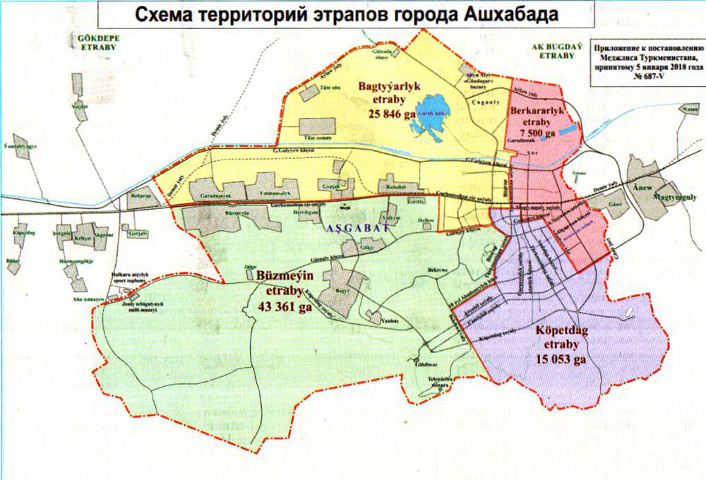
OpenStreetMap logo OpenStreetMap

apm-wa's Diary

Recent diary entries

I’m continuing to add accumulated institutional knowledge and references to source materials on Turkmenistan and so far two of its cities in the wiki, Ashgabat and Mary. If anyone has thoughts on what more needs to be added, I will welcome suggestions. Time permitting I will add the other provincial capitals (Balkanabat, Dashoguz, Annau, Turkmenabat) in the coming weeks.

The upload of Mapillary imagery from Balkan welayat continues–down to about 1,800 images out of the 31,000 collected. Most are boring shots of the M37 highway or other major roads, good for mapping but otherwise not terribly interesting. I’ll look through them for shots of camels on the highway and other items of interest.

I also shot Mapillary images of the busts of Turkmen literary and musical notables in Ylham Park. You may see the busts here and here. These are all now mapped in OSM for use by tourists and others.

Location: Kopetdag District, Ashgabat City, Kopetdag District, Ashgabat City, Turkmenistan

I have geolocated and mapped all Russian Orthodox Churches cited on the website www.pravoslavie.tm/prikhody. Some were already mapped, but not all. This has involved in a few cases driving to the cities in question, asking locals where the church is located, and driving to it to mark it. In other cases it has involved querying locals as to the location and having them point it out in Digital Globe imagery for me. That last one we found was the Church of the Apostle Thomas in Tejen, which someone had mistagged as a mosque. Many thanks to all who helped!

This week I traveled to Mary and collected a few thousand Mapillary images along the M37, which are in the process of being uploaded. I identified some more POIs plus have updated some obsolete street names. There are three major hotels in Mary (Mary, Margush, and Yrsgal), and all three are now well marked in OSM for the convenience of travelers. There is also a new supermarket, Belent, and it is marked now as well. That’s not to mention the out-of-the-way Gas Station 19 on a rural road that we stumbled across!

Location: Tejen, Tejen District, Ahal Region, Turkmenistan

The Hand-Cut Pass Through Solid Rock in Turkmenbashy, Turkmenistan

Posted by apm-wa on 12 May 2018 in English. Last updated on 13 May 2018.

Do a virtual drive via these Mapillary images I took last week of the pass cut by hand by Japanese prisoners of war after World War II. The pass was carved out of solid rock using hand tools.

There is a small memorial to Japanese POWs at the top of the hill.

So far about 5,000 of the over 30,000 images I collected on this trip have been uploaded. I copied them from my smartphone to my desktop computer and am using the desktop interface with Mapillary.com to upload them. Due to the slow internet speeds of the Turkmen internet, it will be a while before all images are uploaded.

Location: Turkmenbashy, Balkan Region, Turkmenistan

The Turkmenistan page in OSM's Wiki

Posted by apm-wa on 11 May 2018 in English.

I am working on the Turkmenistan page in the OSM Wiki, seeking to add information I’ve acquired during my tour of duty here in Ashgabat. If you have suggestions for information that should go on this page for purposes of preserving institutional memory, please sing out! If I don’t possess the information I’ll try to find it during the time left on my tour of duty.

Location: Tejen District, Ahal Region, Turkmenistan

Just spent three days exploring parts of Balkan velayat, including the Yangy Kala Canyon, plus attending the dedication of Turkmenbashy city’s new international seaport. I am presently uploading several thousand Mapillary images, which will take several days at our local internet speeds, so check back in a week or two for updated ground-level imagery. I also collected names of some villages in Balkan velayat on the road between Balkanabat and Archman, and will be adding them as time permits. Lots of fresh data–now just need to find time to enter it all!

Location: Turkmenbashy District, Balkan Region, Turkmenistan

Among the things on my to-do list are checking to ensure that changes to names of places in Lebap welayat adopted in November 2017 have been taken care of. The whole list is in this article in the Russian language. As time permits, I’ll check and edit as necessary. Among other things, the city of Atamyrat and surrounding district have had their old names (Kerki and Kerki etraby) restored. I changed the city name some time back but still have some work ahead.

Location: Chardjuy District, Lebap Region, Turkmenistan

Today I collected house numbers in the Phase 4 development of Taze Zaman, a planned community in the northwest quadrant of Ashgabat. To my surprise, street signs in the new phase in a couple of cases show alternate spellings for the names of the streets. In the old phase, Ebedilik and Abadanlyk are the names of the streets; in the new phase, they are spelled Ebediýlyk and Abadançylyk. Since OSM recommends naming streets as their signs read, the streets are split between the alternate spellings.

At any rate, all houses are now numbered, using the addr:interpolation tag on lines drawn between address points at the end of each city block. The houses are cookie-cutter, so the interpolations should be pretty accurate.

Location: Taze Zaman, Bagtyyarlyk District, Ashgabat City, Turkmenistan

Ene Kuliyeva

Posted by apm-wa on 11 April 2018 in English. Last updated on 25 May 2019.

While exploring the Köşi neighborhood in Ashgabat (itself a former village before being annexed in the 20th century), Ann and I stumbled across a school with a bust of a woman in the school yard. This is unusual in Turkmenistan–a memorial to a woman–so we stopped to photograph it, and the teachers came out to see who the strangers were. We asked whom the bust commemorated. Ene Kuliyeva was an advocate for educating girls in the early 20th century, and was assassinated in Moscow in 1925. The school is named in her honor. I photographed the pages in a three-ring binder the teachers showed us, and am having the text translated from Turkmen into English. We forget too easily the martyrs who made the world a better place and suffered for their labors; I don’t want her to be forgotten.

Ene Kuliyeva bust

Location: Koshi, Bagtyyarlyk District, Ashgabat City, Turkmenistan

Updating Turkmenabat

Posted by apm-wa on 7 April 2018 in English.

A couple of weeks ago I drove from Ashgabat to Turkmenabat then mushed on to the Dayahatyn caravansaray outside Seydi. You can see some Mapillary imagery of the caravansaray, which was in use between the 11th and 16th century on the Silk Road, here

Along the way, I collected over 25,000 ground level images using Mapillary, and over time am uploading them. The new roads built in and around Turkmenabat required a few hours of editing to update but the map of that city and environs is now in much better shape than before.

Location: Danew District, Lebap Region, 746222, Turkmenistan

Statues in Ylham Park

Posted by apm-wa on 18 March 2018 in English.

I finally got around to adding statues in Ylham Park between Gorogly and Azady streets. The Mapillary imagery is available for those interested in seeing what the statues look like.

(https://www.mapillary.com/app/?lat=37.943060305004906&lng=58.37661221628855&z=17&pKey=a8voMY8xqYsMxd2L1uyB7Q&focus=photo)

Location: Kopetdag District, Ashgabat City, Kopetdag District, Ashgabat City, Turkmenistan

Bagyr and Yanbash

Posted by apm-wa on 18 March 2018 in English.

Ann and I spent a chunk of this weekend collecting street names and GPS traces of unmapped streets in Bagyr and Yanbash, former villages (and before that, Soviet collective farm villages) that are now formally neighborhoods of the city of Ashgabat since being annexed. It had rained, and some of the streets were muddy enough we had to use four-wheel-drive! Over the two days we shot over 3,000 Mapillary images while searching for street signs and marking mosques, schools, and other POIs on the GPS. The GPS traces are public so anybody has access to them.

With these two neighborhoods largely done, we have completed base mapping of all neighborhoods of the greater Ashgabat metropolitan area, i.e., everything inside the new city limits. Much remains to be done–more POIs, new buildings soon to be under construction in central Ashgabat, and a number of streets with no names (and we missed a few in Bagyr this weekend), but we are in a better place now than before.

Location: Bagyr, Ashgabat City, Turkmenistan

Happy International Women's Day!

Posted by apm-wa on 8 March 2018 in English.

Ann and I celebrated International Women’s Day (an official holiday in Turkmenistan, so I had the day off) by exploring two former villages annexed by the city of Ashgabat, so they are now officially neighborhoods: Yalkym and Herrikgala. We collected street names and some POIs, plus shot lots of Mapillary images. Very interesting to see large mansions in these quasi-rural former villages, cheek by jowl with greenhouse operations, plus households with up to 16 cows, and camels. The Mapillary imagery is being uploaded as I type this so please give it a few (or several) hours before looking for it.

Location: Yalkym, Ýalkym, Ashgabat City, Turkmenistan

Bad Weather = Bad Imagery

Posted by apm-wa on 4 March 2018 in English.

March 1-2 I traveled to Yoloten and Mary, and passed through Tejen, and tried to collect ground-level Mapillary imagery…during and after a rain storm (unusual in arid Turkmenistan, but not unknown in winter). I must apologize for the poor quality imagery. It was just too dark and gloomy. I collected some useful data and have added information to the maps of Yoloten, Mary, and Tejen (including Tejen’s only hotel, which charges 6 manat or $1.71 per night). Nonetheless some of the imagery is less than marginal. Sorry! At least I added some street names to these towns, as well as some major POIs.

Today Ann and I cruised the former vilage of Gokje, now officially a neighborhood of Ashgabat since it was annexed, and collected street names, POIs, and fresh GPS traces for streets that have been created in the past year or so. Some streets had absolutely no signage at all. Not sure how we’ll find the names for them.

Location: Yoloten, Yoloten District, Mary Region, Turkmenistan

Ashgabat's western suburbs

Posted by apm-wa on 4 February 2018 in English.

Ann and I celebrated my completion (more or less) of drawing the boundaries of Ashgabat’s four boroughs (etraplar) with a Sunday drive to some of the villages across the border in Ahal welayat (province) to the west. We collected a few POIs and street names, and did some ground truth. The battery died on our Samsung Galaxy we use for collecting Mapillary imagery and the backup battery was also not fully charged…sorry about that (note to self: remember to recharge ALL batteries the night before).

Location: Köpetdag geňeşligi, Gökdepe District, 745190, Turkmenistan

Proposed Admin Levels for Turkmenistan

Posted by apm-wa on 14 January 2018 in English.

Now that I have been editing OSM’s Turkmenistan map for nearly three years, I feel confident enough to offer a suggested set of administrative levels. I invite one and all to take a look at my proposal at osm.wiki/Template:Admin_level_11 and offer constructive feedback. This proposal is based on my by now fairly good knowledge of the political structure of Turkmenistan and the way the hierarchy works.

The last two days have been fairly productive. Ann and I went exploring neighorhoods in Gypjak, Choganly, Taze Eyyam, and Taze Zaman where we were missing street names, numbers of schools, and such. We mostly filled in blanks in the map but also updated some streets in Taze Eyyam plus added a few in the new subdivision being built on the west side of Choganly. We visited the unidentified neighborhood on the northwest corner of the demolished former Ruhabat dacha community, which has absolutely no signs, but asked locals what it is called. They identified it as Galkynysh (Turkmen for “renaissance”), a neighborhood subordinate to the Choganly jurisdiction, which is part of the city of Ashgabat.

The Ruhabat dacha community is definitely gone. We drove through part of the territory, and crews were there watering saplings that have been planted where old imagery shows a dacha community.

Location: Bagtyyarlyk District, Ashgabat City, Bagtyyarlyk District, Ashgabat City, Turkmenistan

Old Names of Towns Restored

Posted by apm-wa on 7 January 2018 in English. Last updated on 10 June 2018.

In November, the Turkmen parliament (Mejlis) restored the former name “Kerki” to the town of Atamyrat. I have restored Kerki to the town and its rail station. This week the parliament restored the name “Bäherden” to Baharly. I have changed it, too. It is not clear why the names were changed in the first place, though Atamyrat Niyazov was the father of Turkmenistan’s first president, and perhaps Kerki was renamed in his honor at one point. Why Baherden was changed to Baharly some time ago is even less clear.

Here are the notifications in Russian of restoration of the former names:

http://www.parahat.info/news/parahat-info-news-15119

https://turkmenportal.com/blog/13059/parlament-turkmenistana-vnes-izmeneniya-v-administrativnoterritorialnoe-delenie-ahalskogo-velayata

Location: Baherden, Baherden District, Ahal Region, Turkmenistan

I spent a little while the last two evenings using the new Digital Globe Premium Imagery for Turkmenistan to clean up some parts of Ashgabat plus areas in the far southeast I visited some months back but was unable to map in detail. This new imagery is terrific. I corrected some rail lines and added rail spurs to factories I either visited or rode past, plus added streets. This is good stuff.

Location: Koytendag District, Lebap Region, Turkmenistan

Today I interviewed some embassy staffers about the status of the Ruhabat dacha community, which appeared on the OSM map of Ashgabat north of the Altyn Asyr (“new Tolkuchka”) bazaar. I have driven past it many times and never seen a house there, but the map shows a significant residential community. It turns out the Turkmen government ordered the entire community demolished in 2013, and by mid-2014 (before I arrived here) it had been eradicated. All houses were torn down and the rubble removed, ostensibly to make way for a new airport and zoological garden, neither of which was built there (the existing airport was expanded, and the zoo was moved to a new site southwest of the city).

I thus removed the point marker for the “town” of Ruhabat, since it has not existed for over three years, and redrew the outlines of the “neighborhood” to correspond to a small village on the northwest corner of the former Ruhabat community. I will have to drive up there to see if that community has a name.

Location: Bagtyyarlyk District, Ashgabat City, Bagtyyarlyk, Bagtyyarlyk District, Ashgabat City, Turkmenistan