OpenStreetMap logo OpenStreetMap

apm-wa's Diary

Recent diary entries

Proper mapping requires ‘‘en situ’’ observation of the POIs to be mapped. Ann and I accordingly took a break from our other duties to investigate the Argentina Pub, conveniently located about 10 minutes’ driving time from our house. Good pizza and salad (I was driving so alas could not partake of any nectar). It also offers steaks, which we will also investigate in due course. osm.org/way/621972265

That said we have broken 300,000 Mapillary images and 11,000 kilometers of imagery collection.

Last week I met the head of the Turkmen Motor Roads State Concern, and he confirmed my list of national highways was nearly complete (one highway was missing, which he provided but which still lacks a route number; I have added it to the list in the wiki). My next “armchair” project when duties preclude getting out on the road will be to identify the national highways with appropriate tags. If Turkmenistan is to become a transportation hub for Central Asia, it will need a decent online road atlas. OSM is currently the best map of the country available to the general public.

Location: Vosmushka, Bagtyyarlyk District, Ashgabat City, Turkmenistan

Southern Balkan Province

Posted by apm-wa on 1 September 2018 in English.

Last week I took two days to tour parts of southern Balkan Province in Turkmenistan, hitting the towns of Etrek, Esenguly, and Ekerem, as well as the villages of Oboy and Daneata (the villages are now on the OSM map based on this ground truth). En route for the first time I filled a 32 Gb memory card with Mapillary imagery and had to install a backup SD card in the Samsung Galaxy smartphone I use for collecting ground-level imagery. Those images are being uploaded now. It may take a few days, since the internet here is so slow.

It will take a while to enter all the edits from data collected on this trip. Much of the M37 is now four-lane dual carriageway (divided highway) so I need to add all the U-turns I marked on the Garmin GPS as well as lots of POIs.

The route took me within a stone’s throw of the border with Iran, but we only saw a few Iranian tractor-semitrailer rigs on the roads. Road conditions between Etrek and Ekerem were rough to very rough, with speed averaging 25 to 30 mph (40 to 50 kph). GPS traces have been uploaded from the Garmin nuvi, Pocket Earth, and Mapillary gpx file.

We discovered two new gas stations and confirmed a suspected third one. In Ekerem (formerly called Okarem, but the signs we saw are clearly labeled Ekerem) we lunched on Turkmen meat-filled somsas that cost 2 manat (about 57 cents) apiece from the only cafe in town while tailgating on the beach.

Location: Esenguly District, Balkan Region, 800245, Turkmenistan

Ashgabat's Changing Boundaries

Posted by apm-wa on 7 August 2018 in English. Last updated on 25 May 2019.

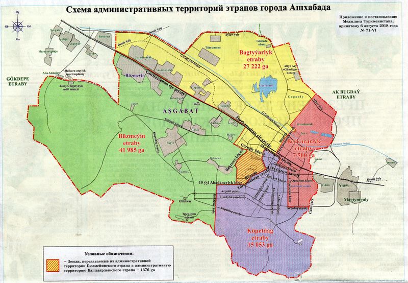
Today’s newspaper carried news and a map of an internal boundary shift of two of Ashgabat’s boroughs (“etraplar”). About 1,376 hectares of land has been shifted from Buzmeyin etrap to Bagtyyarlyk etrap. More map editing ahead.

The newspaper also said the mayor proposed annexing more territory into the city, which means it is highly likely the outer boundary of Ashgabat will change again in the foreseeable future. Even more map editing ahead!

Boundaries of Ashgabat as of 6 August 2018

Location: Buzmeyin District, Ashgabat City, Buzmeyin District, Buzmeyin, Ashgabat City, Turkmenistan

Saturday we went for a drive, to scope out the border crossing to Iran at Artyk, about an hour and a quarter’s drive east of Ashgabat, mostly out of curiosity. I’m glad we did–there is a new bypass road from the M37 straight to the border crossing that had not been mapped and does not appear on any satellite imagery in the OSM editors. We collected GPS traces and Mapillary imagery (now being uploaded) and will work on updating this approach. While there, we mapped most of the village of Artyk, collecting street names (lots of signage!)

Then on the return we stopped in Balykçylyk to find out if we can buy fresh fish from the fish farm there (yes, we can!) and mapped most of that village as well as the fish farm itself. Our final major mapping foray was Ýaşlyk, site of the Berk brewery as well as, it turns out, a rather large jail.

I had never driven the old highway that used to be the only road connecting Ashgabat and Mary, so we decided to take it back to Ashgabat instead of the M37. We discovered that the road stops abruptly at what used to be a railroad crossing, but now is a dead end at the railroad tracks. We used OSM to navigate on back roads till we came out on the M37 again, but had we not taken the alternate route, we would not have noticed in satellite imagery that the railroad crossing had been decommissioned.

Location: Artyk geňeşligi, Kaka District, Turkmenistan

Cleaning Up Ashgabat

Posted by apm-wa on 21 July 2018 in English.

MAPS.ME is a great app, and Ashgabat users suffering from high internet costs (the highest in the world, we are told) have found it a cost-effective way of uploading POIs. In certain important respects, this is a boon to mapping Ashgabat and other cities in Turkmenistan.

There are, however, two issues. First, the mappers often mis-tag POIs, either because they don’t know English too well (some mappers tag all medical or health facilities “amenity=hospital”, for example, including pharmacies, clinics, and ambulance stations), or because MAPS.ME’s limited universe of point tags doesn’t lend itself to proper tagging. Second, because MAPS.ME’s offline maps are updated relatively infrequently, multiple mappers add a POI multiple times, so you end up with two or three new entries for the same POI. This has created a fair amount of work for me, cleaning up after entry of POIs that either duplicate an existing node, usually consolidating all data from multiple entries, or simply correcting tags. I’m not complaining–there are worse problems (like vandalism), but it does take time.

The good news is that this weekend temperatures in Ashgabat will be well over 100 Fahrenheit, mid-40s Celsius, so I have a great excuse to stay close to the air conditioner and edit the map.

Location: Howdan W, Kopetdag District, Ashgabat City, Turkmenistan

Yesterday I had too many other obligations to travel far, so I took about three hours of Saturday afternoon to cruise parts of Ashgabat I’d not visited for a while and to collect Mapillary imagery where there were gaps (uploads currently underway). The dacha community north of the Karakum Canal on the far east end of the city is gone. It was apparently demolished in the past months and has been bulldozed. I had no idea, but will have to revise the map. The road into the community has been blocked with a dirt pile. This is why ground truth is so important.

I have completed corrections to the A-381, P-1, P-15, P-16, and P-18 national highway routes in Turkmenistan. I have consulted with local sources to nail down exactly which roads are part of each route and think these five are now pretty accurate.

Location: Berkararlyk District, Ashgabat City, Berkararlyk District, Ashgabat City, Turkmenistan

I have found an authoritative but slightly out-of-date list of provinces, districts, and municipalities in Turkmenistan, have corrected and updated it based on recent press releases, and posted it to the OSM wiki:

osm.wiki/Districts_in_Turkmenistan

I am also working with my embassy’s motor pool to identify the national highways, which are either not tagged or are in some cases mistagged. This will be a bit of a project over the summer as we research the Turkmen national highway system and bring the OSM map up to date. My ambition is to have a complete map of Turkmenistan’s national highway network, all properly tagged.

I have been unable to find an authoritative official list of the districts (‘‘etraplar’’) in Turkmenistan’s five provinces, so have cobbled together a list for each province based on whatever official press releases, news items, and other sources (including personal travel to some of them) I could find. The results have now been typed into the wiki pages for each of the provinces:

If anybody has corrections to any errors of omission or commission, please make them and let me know! These lists are accurate and up to date so far as I can tell, but nobody’s perfect.

As of today I have broken a quarter of a million images uploaded to Mapillary that any OSM user can use for helping map Turkmenistan. I still have over 20K more images to upload from the Serhetabad trip and last Monday’s day trip to Magtymguly (Garry Gala).

Sometime this year I will depart Turkmenistan, so am feeling some pressure to collect as much data as possible before moving back to the United States.

Day Trip to Garry Gala (Magtymguly)

Posted by apm-wa on 27 June 2018 in English. Last updated on 25 May 2019.

Monday we drove to Magtymguly, a village in Balkan Province, formerly known as Garry Gala, to check out the area. You can see my route in the Mapillary GPS trace here. Mapillary imagery will be uploaded as Internet connectivity permits, so check back in a couple of weeks (it will take a while).

We added some villages, a gas station, some other POIs, and I mapped a river, the Aydere (which in Turkmen means “Moon River”). The Sumbar River valley is beautiful, very scenic, and there are some gorgeous mountain scenes that will eventually show up in Mapillary for those interested.

One section of the route took us through a landscape known as the “Mountains of the Moon”. I shot a Mapillary sequence with my iPhone, which you can see here: https://www.mapillary.com/app/?lat=38.45498688522582&lng=56.20510593993236&z=17&pKey=F1UZu4iMblKil4hVAcwPeA&focus=photo

Mountains of the Moon

Location: Magtymguly District, Balkan Region, Turkmenistan

You learn something new every day. Monday I traveled to Serhetabat, on the border with Afghanistan, and collected Mapillary imagery en route that is now being uploaded (please be patient, the Internet is slow here). Mapillary also collects accurate GPX files along with the images, and I have learned that if I copy them from the SD card onto my computer, pull them all into EasyGPS, and save them merged as a single file, I have an accurate GPS trace of my entire route. I may be a slow learner, but I’m at least still learning!

On a hilltop in Serhetabat one finds one of four crosses erected by the Russian Empire in 1913 to celebrate the 300th anniversary of the Romanov dynasty. The four crosses marked the four farthest flung points of the compass, and this was the south compass point. The other three have been taken down but this cross survives.

Southern Cross of the Russian Empire, from Mapillary

Location: Serhetabat, Tagtabazar District, Mary Region, Turkmenistan

A Gazetteer of Ashgabat Street Names

Posted by apm-wa on 15 June 2018 in English.

I have posted a Gazetteer of Ashgabat Street Names which represents hours and hours of digging through Russian- and Turkmen-language materials in search of information on where these street names came from. In the course of this research over the past three years I have learned a great deal about Ashgabat’s and Turkmenistan’s history, and hope others will take time to browse the material collected so far.

Location: Kopetdag District, Ashgabat City, Kopetdag District, Ashgabat City, Turkmenistan

Ann and I drove up to Nohur, an ancient Turkmen village she had not yet seen. Alexander the Great came through here a couple of thousand years ago and left some of his legion behind. They settled in Nohur and their descendants are still here, some still with green eyes inherited from their Greek forebears. The village is famous for its watermelons so we bought one. While there I recorded the names of two of the three cemeteries not yet mapped and have now added them to OSM. I have to wonder how many of Alexander’s soldiers are buried in them!

When the Mapillary images are uploaded (currently in progress) you can see some of the headstones, which are decorated with ram’s horns. Nobody seems to remember exactly why, but it is apparently a custom left behind by the Greeks.

On the return to Ashgabat, we stopped to explore Durun, a typical former Soviet state farm village. It is small so we recorded every street name in the village represented on a street sign (not all streets had signs), plus some POIs. My embassy has published six American books in Turkmen translation so we gave books away to the villagers as we drove around collecting cartographic information. Word spread and at times we were mobbed by children wanting their own copy of “Harold and the Purple Crayon” in Turkmen. All in all it was a very enjoyable Sunday.

Tomorrow we’ll start eating the watermelon.

Location: Nohur geňeşligi, Baherden District, Turkmenistan

As of the last upload of images from a trip across the Karakum Desert to the city of Dashoguz, and visits to sites in and around Dashoguz, I have contributed a bit more than 200,000 Mapillary images, the vast bulk of them in Turkmenistan and the vast majority taken in areas where nobody else had captured ground-level imagery to that point. I hope some of you will take the opportunity to visit Turkmenistan virtually via Mapillary, since Turkmenistan issues only about 11,000 tourist visas per year and is one of the least visited countries on the planet There are some marvelous sights, however! I’m trying to capture as many as I can.

Somebody vandalized streets I had drawn in Awaza, the resort zone on the Caspian Sea shore. He (yes, it was a male of the species) disconnected streets and moved them around, then added nonexistent streets. I don’t understand why someone is motivated to vandalize a map database. It is all repaired now, but repairing the damage cost me time I could have spent doing something else.

I have at least started OSM wiki articles on the major cities of Turkmenistan, as follows:

*Ashgabat *Balkanabat *Dashoguz *Mary (Turkmenistan) *Turkmenabat *Turkmenbashy

The intent is to institutionalize all I have learned about mapping in Turkmenistan so far, before my tour of duty ends sometime this calendar year. If other mappers have suggestions for information to add to these articles, I am all ears.

I drove, or more precisely was driven, from Ashgabat to Dashoguz across the Karakum Desert on May 29, collecting Mapillary imagery (presently being uploaded, please be patient) and location data for POIs using Pocket Earth and MAPS.ME. We collected the numbers of the gas stations and the names of villages (i.e., navigation waypoints) en route plus locations of clinics and the district hospital in Ruhubelent. Met a Dutch tourist at the cafe near the Darwaza fire crater who was navigating with MAPS.ME and said it was extremely useful for getting around both Iran and Turkmenistan.

Once in Dashoguz we spent some time collecting more street names, some POIs, and correcting a few anomalies. If tourism ever is allowed to flourish in Turkmenistan, this will be a major route from points in Uzbekistan to Ashgabat.

You may notice in the ground-level imagery taken May 29 that the sky is white and visibility is limited to about a mile. This is because the area was subjected to a salt storm caused by winds kicking up salt from the desiccated seabed of the evaporating Aral Sea. This ecological disaster confronted us travelers in a particularly stark manner.

Location: Ruhubelent District, Dashoguz Region, Turkmenistan

During another trip to Turkmenbashy to attend the 9th Annual Gas Conference, I took a few hours to collect more GPS traces and Mapillary ground imagery in and around Turkmenbashy, including the seaport dedicated on May 2. The updates to the seaport are uploaded now–additional roads, placement of important terminals (including the passenger and ro-ro terminals), and tweaks to the approach roads.

We also geolocated the Kazakhstan and Russian consulates in Turkmenbashy, which means we now have all diplomatic and consular missions in Turkmenistan on the map, complete with addresses and telephone numbers. We located and collected contact information for the three downtown hotels (Charlak, Hazar, and Turkmenbashy), i.e., those not located in the Awaza tourist zone.

I also started a wiki page on the city of Turkmenbashy, as a companion to the pages on Turkmenistan, and cities of Ashgabat and Mary. All of these are far from finished, so please be patient as I collate information and upload it. If you have suggestions or criticism or thoughts on these pages, please sing out!

Location: Turkmenbashy International Seaport, Turkmenbashy, Balkan Region, Turkmenistan