Today I received OSMcard #B6456 from Zervreilasee in Switzerland. What a nice surprise, thank you Stefan!

this is Zervreilasee in OpenStreetMap: osm.org/way/18828382
Today I received OSMcard #B6456 from Zervreilasee in Switzerland. What a nice surprise, thank you Stefan!
this is Zervreilasee in OpenStreetMap: osm.org/way/18828382
From time to time, people point to weird situations they encountered in their mapping. I’m going to collect some of these in this diary entry (and comments).
In a discussion about traffic signs, the German forum mentions a node with a German traffic sign in France (on a track leading to Germany). As you can see, the reason is a track that starts on the French part but the only destination is back to Germany.
 # The wiki
The OpenStreetMap Wiki is a great resource of information, with a huge, active community (603 different editors in the past 30 days). This community is highly diversified, many people make the occassional spell-fixing, small addition or clarification or removal when something doesn’t seem completely right to them, there are people mostly translating content into their local language, people obsessed by organization and structure who reorganize and “templatetify”, specialists who care only for specific fields of endeavour, people who make elaborate proposals with subtags to cater for many details and all eventualities, or that set up page stubs for newly discovered tags, or local comunities organizing mapping and events, software and operations documentation and much more.
# The wiki
The OpenStreetMap Wiki is a great resource of information, with a huge, active community (603 different editors in the past 30 days). This community is highly diversified, many people make the occassional spell-fixing, small addition or clarification or removal when something doesn’t seem completely right to them, there are people mostly translating content into their local language, people obsessed by organization and structure who reorganize and “templatetify”, specialists who care only for specific fields of endeavour, people who make elaborate proposals with subtags to cater for many details and all eventualities, or that set up page stubs for newly discovered tags, or local comunities organizing mapping and events, software and operations documentation and much more.
While the following could in theory apply to all wiki pages, it seems that most contested edits are regarding tag documentation.
These are the most frequently used opening hours for museums and other art related features in OSM. Apparently, most are closed on Mondays, or do not close any particular day: count value
263 Tu-Su 10:00-18:00
199 Tu-Su 10:00-17:00
186 24/7
175 unknown
144 Mo-Su 10:00-18:00
119 Mo-Su 09:00-17:00
110 Mo-Su 10:00-17:00
87 Tu-Su 09:00-17:00
67 10:00-18:00
63 10:00-17:00
61 closed
60 9:00-17:00; Mo closed
59 Tu-Su 11:00-17:00
52 9:00-17:00
50 Mo-Su 09:00-18:00
48 Tu-Su 11:00-18:00
43 09:00-17:00
43 Mo-Fr 09:00-17:00
42 Tu-Sa 10:00-17:00
40 Mo-Su 10:00-20:00
40 Su 14:00-17:00
39 Mo-Su 10:00-19:00
38 Tu-Su 09:00-18:00
38 We-Su 10:00-18:00
33 Tu-Su 10:00-16:00
30 “on appointment”
30 Tu-Sa 10:00-18:00
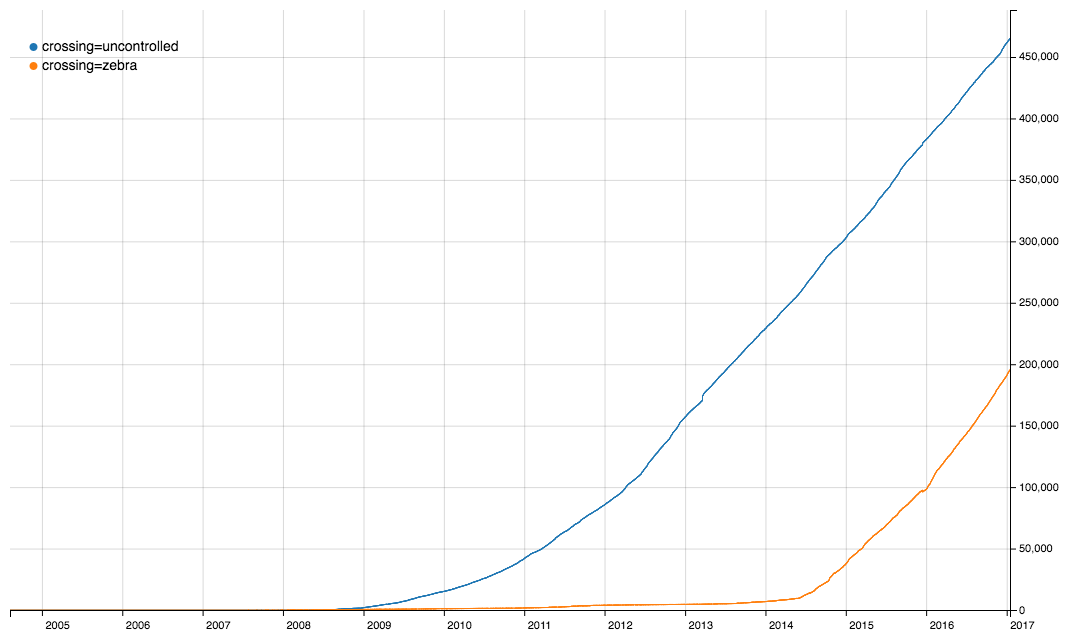
After some tagging chat on the Italian ML it came to my attention that iD is setting crossing=zebra tags on crosswalks, a tag that is not documented as value for the crossing key, besides in the UK. As I believe that using different tags for the same thing - although not really harmful - makes everyone’s lifes a bit more complicated, I thought I’d give them a hint, after all, usage of this tagging is still behind the longer standing established and documented one.
 So I created this issue: #4316.
It came up, there are already 3 tickets where the same issue had also been dismissed.
IMHO, we should take care that editing software proposes the same presets for the same objects and properties (not necessarily the same level of detail, or presets for the same things), because tag fragmentation is a burden on everyone. In this case it is very clear that crossing=zebra only came to significant use when it was added as a preset in iD in May 2014 (compare with the graph above).
Trying mapbox custom overlays, I was quite shocked from the outcome of my first attempt to show an overlay on mapbox vector tiles.
I have extracted some OSM data to display on a custom map, converted it to geojson with Martin Raifer’s osmtogeojson tool and uploaded it to mapbox via their cli suite (the only reason for using a cli tool for a one time operation is that my geojson is 80MB and mapbox only accepts max. 5MB file size for the browser upload. The cli accepts a geojson in input but doesn’t make a “dataset” of it, it directly converts them into a “tileset”, and that was apparently where the problem lay).
For example the Diocletian Thermal Baths in Rome (a museum), this is the relation in OSM, and this is what I got at first after uploading it to MapBox:  .
.
As you can see, the data in this form would be completely useless (all polygons in the dataset had been defaced in a similar way). This is because of the max-zoomlevel (indicates simplification) set to 9 by default.
Probably everybody has guessed it, but here is a proof with Jan 2017 data: OSMF members are mostly living in Europe and the US, with a concentration in London, Germany, and in the US on the East Coast (Washington and NYC) and in the Silicon Valley.
I only recently discovered that Jochen Topf has published a command line tool based on his great Osmium library. The Osmium library is a C++ library optimized for working with OSM files in different formats like XML and PBF and is very fast. While the original library is geared towards developers (besides the c++ version there are also python and node bindings), the command line tool is great for normal users.
To give it a try, I decided to have a look at an Italy extract from Geofabrik I had downloaded in March and which was still lingering on my disk. Linux and Mac users know, the great potential of the shell lies in the ability to perform multiple commands in sequence by piping the output of one operation to the next tool in the chain.
Here is what I used to get a list with the last modifiers (mappers) of every object in the file, sorted by the number of contributions (only current version of undeleted objects have been counted here, but Osmium-tool also allows for analyzing full history files if I am not misguided):
osmium cat 20170302_italy.osm.pbf -f opl|cut -d' ' -f7|cut -c 2- \
         |sort|uniq -c|sort -nr|head -n 250 >italy-top250.txt
I’m not very good in using the shell, so maybe this command line can be improved, feel free to suggest improvements in the comments.
| The binary extract I used is 1.2GB and was sitting on a network share and I was using a slow dual core MacMini (this is why there aren’t spaces around the | pipe symbol, the Mac shell doesn’t like them) so it took a while (maybe half an hour), also because the sort command in the shell takes some time, but IMHO this is totally acceptable for occasional use. |
In case you are interested, this is the output (I have numbered the lines with cat -n. Unfortunately there seems to be a bug or a feature so that the markdown in this diary is removing the newlines). Needless to say, many of the higher ranks have been “cheating” by importing big amounts of data ;-)
Today I was asked by another (very active) mapper via email these questions:
We are currently discussing best practices for landuse mapping in Belgium. Some of the problems:
- do you use multipolygons to avoid overlapping landuse or do you split a residential landuse so you can have smaller landuses ? Or do you just overlay them ? A lot of landuse is already mapped in a rough way, so we typically have large areas of residential landuse.
- Do you include streets in residential landuse or do you exclude them so one can later add area:highway or landuse=highway ?
- I’m in favour of landcover to avoid “forests” in gardens. Which landcover proposal do you follow ? (I believe there are 2).
- what about grass/bushes in towns near highways ?
I wrote some lines how I believe it should be done. Here’s a slightly modified version:
Regarding the residential landuse, I am since almost 10 years advocating to not include roads but end the landuse at the property borders. Not only does it add more detail, because you can clearly distinguish (even without roads), parcelled land and common land, it will also be easier to add landuse=highway, i.e. the land that is legally a road. It just makes no sense from a legal point of view to add streets to the residential landuse (save maybe those areas where the streets are private). I do include driveways though, i.e. “roads” on the properties.
Clearly, public roads are road landuse, so they must not be included in residential, industrial, commercial, retail or other similar landuse.
IMHO the 3 reasons for people to include roads are
This is a follow up of my recent diary entry about the centre of Rome and in parts a reply to Warin61’s comment to that post.
I believe the local people usually know where the centre is. They tell you when you ask them. Give it a try, I bet you’ll see that you get similar answers.
I would expect this most central spot to be often in front of the townhall (maybe sometimes the cathedral) or the main market square (in traditional towns) or likely both. Maybe the train station can be such a center as well (in more recent towns which developed after the railway was invented).
One criterion could be: where would you go to protest something. If you were to gather together with “all” citizens, where would you go.
Streetsigns aren’t useful from my experience. Often the centre is inside the main pedestrian area (typical for Germany, where many historic city centres have been pedestrianized) and it is generally so big that you will get signs in the outskirts indicating “city centre”, but when you arrive there will not be a sign stating “this is the city centre”, the signs will simply stop indicating a centre when you are in a central area (they might indicate “all directions” now, but that’s a different story, maybe to be told another time).
There a very useful feature in JOSM which I just discovered now: when looking at the history diffs of an object and you choose the coordinates tab, you get a map visualizing the geometry in a map.
From time to time people are moving the Rome node.
I found it interesting to see how the position changed by the time. This is the complete position history of the Rome node:
The node creation on 2007-10-15. Back then the local map was empty and a node anywhere near the centre was perfectly fine, but the editor decided after 10 minutes he could do better and already refined to a location close to where the central point commonly is associated with (the Campidoglio).

Just discovered this POI, someone offering lessons in mathematics and accepts bitcoin. Apparently he is living in the middle of the street: osm.org/node/3197308571