jonwit's Comments
| Post | When | Comment |
|---|---|---|
| Sikkim stories | Looks cool, How about a map address? A simple search reveals a mountain peak and not the monastery |
|
| Hello | Hello!! |
|
| Melbourne tram stop project - first post | Welcome! |
|
| Declaration of Conflicts | ||
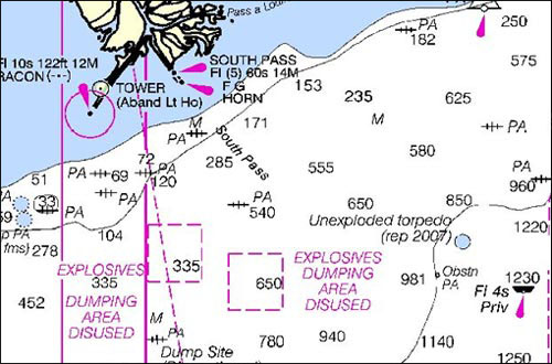
| Proposed talk at both SOTUM and HOTOSM conferences!! | Even in the oceans we have these features
|
|
| Proposed talk at both SOTUM and HOTOSM conferences!! | Landuse is defined as: Mainly used for describe the primary use of land by humans. They could be classified under landuse=military however…. I could argue that the main goal of a minefield would be to prevent the movement or use by humans. I am going to argue that Hazard is a proposed feature that could provide more depth. I am also new to openstreetmap and so a more seasoned individual would be able to offer more valuable insight. |
|
| Proposed talk at both SOTUM and HOTOSM conferences!! | Thank you @Hedaja. It seems like the area is lacking in tagging. Its something for either individuals with local knowledge or NGOs with databases. For example the UNDP in Bosnia UNDP in Bosnia issued a series of maps showing flooding and mines from the series of floods in the area. Unexploded ordinances are also a factor as well.
The question is whether such features should be mapped on openstreetmap or kept in a separate database that can be overlaid on top of openstreetmap when needed. |

 This map shows the contamination from U.S. bombing in Cambodia during the Vietnam War.