OpenStreetMap logo OpenStreetMap

mcld's Diary

Recent diary entries

Cross posted from mcld.co.uk

On Wednesday we had a “flagship seminar” from Prof Andy Hopper on Computing for the future of the planet. How can computing help in the quest for sustainability of the planet and humanity?

Lots of food for thought in the talk. I was surprised to come out with a completely different take-home message than I’d expected - and a different take-home message than I think the speaker had in mind too. I’ll come back to that in a second.

Some of the themes he discussed:
See full entry

RFC: wikidata->osm lookup table

Posted by mcld on 22 March 2017 in English.

OpenStreetMap has a wikidata tag which lets us connect OSM objects to their corresponding Wikidata items.

(Technical note: it’s a “same as” relationship - i.e. the tag asserts that the two items in different systems refer to the same entity. However, sometimes things in OSM are split into multiple objects; and sometimes one object in OSM actually refers to multiple items in Wikidata. So it’s actually a “many-to-many” matching, not “one-to-one”: a single OSM object sometimes has multiple semicolon-separated Wikidata identifiers, and multiple OSM objects sometimes have the same Wikidata identifier.)

There are over 600,000 OSM objects with the “wikidata” tag. OK great, job done? I mean, nothing’s ever “complete” in these big open-ended crowdsource projects, but if we have more than half a million crosslinks between the systems, that’s really good going.

BUT THERE’S A PROBLEM!

Using the tag to jump from OSM to Wikidata works fine. But from Wikidata to OSM? Well, there’s no persistent way to link from wkd->osm, simply because OSM’s identifiers are impermanent - they’re not guaranteed to continue existing, or to continue referring to the same thing. So it’s not particularly sensible to store OSM identifiers in Wikidata. Instead, an Overpass lookup is required.

For example, on the OSM Wikidata page I found this friendly Wikidata interface called “Reasonator” - all very nice, but instead of cross-linking immediately to the OSM object, it offers a little “Overpass” link which you can click to do a dynamic lookup.

The effect is that it makes Wikidata->OSM connections indirect, obscured, only-for-those-who-know-they-want-it. If a Wikidata coder says “OK great how do I jump to the item in OSM?” you first have to teach them what Overpass is and how it relates to OSM, then how to use its query language, how many queries a day you’re allowed to do on Overpass… bleh.

PROPOSED SOLUTION

See full entry

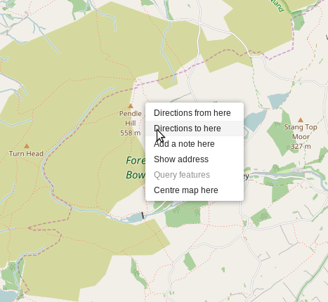
It gives me great pleasure to announce that the OpenStreetMap website now has a context menu! Also known as a right-click menu:

Context menu in action

You might not think this is big news, but I do. A few people asked for this feature in the past, and eventually I proposed some code for it. It took 18 months for the proposal to be merged into the website codebase - why? Primarily because OSM is built and run by volunteers with limited time, but also because my Javascript skills weren’t quite up to adding the important polish and tests that are needed for production-ready code. A million thanks to Tom Hughes for improving my not-quite-finished proposal, and for all the feedback that helped me understand how to do things right.

When we run mapping parties as part of the HOT work, we see lots and lots of newcomers mapping for the first time. Increasingly we’re getting them using iD which is very easy for them to get started with.

One little issue I noticed in sessions is that for HOT we ask people to use very specific changeset comments - essentially to “tag” the changesets as belonging to a particular labelled task. It was very easy for people to spend half an hour mapping and after half an hour have no memory of what we said about copying-and-pasting a specific comment. Workflow problem!

Now, the team who create the iD editor kindly added my feature request which means that the HOT Tasking Manager can now “pre-fill” the changeset comment in the iD editor. So no need to copy and paste, it should be there when you click through from the Tasking Manager.

What does this mean? It means that in future, HOT mappers using iD will not need any reminding about what to put in the comment box! Easier mapping, easier training, more consistent changeset comments.

Thanks everyone who helped put this through.

(P.S. There is one little technical niggle to resolve - if the comment contains an equals sign then the pre-fill doesn’t work on firefox. Hopefully sorted soon.)

London: Searching for Globe Town

Posted by mcld on 7 September 2014 in English.

In East London, there’s a part of Bethnal Green called “Globe Town”. It’s not very well known, but it’s actually indicated by some globe artworks sprinkled around the area - see the photo in this nice article, for example: http://hidden-london.com/gazetteer/globe-town/

I decided to go and do some Bethnal Green mapping today, at least in part because Globe Town wasn’t really in OSM yet and also because I’m not even aware of an official definition of the bounds of Globe Town. So I went looking.

my fieldpaper

I’ve placed a marker to name the Globe Town locality, and I chose to place it in the Globe Town market square. Is that the centre of Globe Town? I have no idea. But it’s at least a prominent place associated with that name.

I also mapped one of the Globe Town globe artworks. I’ve seen a few of them around but I can’t remember where - I’ll just have to add them as I find them.

See full entry

Well it finally happened...

Posted by mcld on 23 August 2014 in English.

Well it finally happened… last night I went to a pub, and I printed out an OSM map to find the way. However, 8 days earlier, someone had moved the pub to the wrong location! That’s the kind of risk we run in an open crowdsourced system.

Luckily my beer hunting skills outweighed my trust in open data and I found the pub eventually. Pint drunk, map fixed, crisis averted.

I’m at the OpenStreetMap Hack Weekend March 2014. Things done:

  1. One of the things I’m really happy about is that Richard Fairhurst’s addition of routing to the OpenStreetMap main website is really close to being ready - just a couple of tiny bugs and UI bits to iron out, and who knows, maybe it’ll go live soon. I helped with a couple of little improvements and fixes.

  2. The other thing is a conversation with new mapper Micky Allen, who is interested in mapping blue badge parking spaces. It turns out that in OSM we have a handy tag capacity:disabled=*, which is already used quite well in London, but we just need a bit more community effort to map these “blue badge” parking bays whenever we see them. Micky now has some ideas about how to extract these data from OSM, and he also has some ideas about encouraging the community to join in mapping them. I’ll certainly try and remember to map them when I see them.

  3. Next thing we’ve done this afternoon - some improvements to v2 of the HOT Tasking Manager. I’ve made it auto-unlock locked tasks after time (feature migrated from v1) as well as a couple of smaller tweaks.

As a contributor to OpenStreetMap, one thing I’ve been wondering recently is what sort of map data should we collect for the UK, now that the coverage has already got good. Since OpenStreetMap generally has great coverage of the UK, when you’re out and about with a printed-out map and a pen, it’s very rare that you can find much significant that isn’t mapped already - sometimes a new street or a missing church. You could pour your time into mapping increasingly obscure things, whatever you’re interested in. But what would be the most useful things to map in the UK, over the coming year? Things that are not just interesting to map but could be practically useful to people? Some thoughts:

See full entry

Remember to map post-boxes

Posted by mcld on 5 October 2013 in English.

I don’t think I used to map post-boxes. Partly because I’m not that interested in them, partly because I sort of assumed they should have been imported en masse at some point from a Royal Mail open data dump of some sort (naive?).

But when I read SK53’s interesting post about the completeness of post-box mapping in Britain, I was really surprised to learn that OSM had less than 50% of the postboxes in Britain. So I’ve started mapping post boxes when I come across them.

As it turns out, I could have started with the one at the end of my road. It was already there in the map, but it had the wrong reference number, though I only noticed that recently. Even in central London and central Birmingham (two hyper-mapped cities) I’ve found some postboxes that have sat there unmapped for years.

Anyway, a quick search finds that I’ve added or fixed 79 post-boxes in the map so far. Mappers, next time you see a post-box, please map it - post boxes are useful things to have on a map…

One of the great things about editing OpenStreetMap is that it leads me to discover new bits of my local area. I’ve just come back from a lovely walk in North-East London, a walk which I would have never thought of doing if it hadn’t been for OSM. And what’s more, it led me to discover a really lovely seafood place for lunch!

Here’s how I do it:

  1. When it’s a nice day and I fancy a walk, I go and look at ITO’s FIXME map, which simply highlights all the objects in the map with “fixme” tags. Most of the time the issues described in the tags are things that can be fixed if someone goes to survey the place (e.g. “check name”, “does this footpath really exist”). I pick a few of these fixmes, not too far from home, as waypoints for my walk.
  2. I usually also go to walking-papers and print myself a simple walking map of the area. I note on this map, the things I need to check.
  3. Then I go and walk. These days I usually record the GPS trace of my route using my Android phone (I use the “OSMTracker” app) - it’s handy but not necessary; just walking around with the piece of paper is fine. For some purposes I prefer scribbling on paper, while sometimes it’s quite handy to store notes in the phone.
  4. When I come back, I upload the GPS trace and use my notes to update the map, fixing things and removing the “fixme” tag wherever I’ve actually fixed something. The aerial photos that OSM offers (via Bing etc) help to jog your memory as you edit, and often prompt me to add features that I didn’t explicitly note down while I was walking.

Really the best thing about this is that while I’m directly fixing things that people want fixing, I’m also discovering bits of my local area that I had no idea about. There was one walk where I discovered an entire park in North-East London that I had never heard of before (and wasn’t properly mapped yet, either).

The highlight of today was that my route led me past a fantastic seafood place, and just in time for lunch as well!

Rejigging the OpenStreetMap browse page

Posted by mcld on 21 September 2013 in English.

On OpenStreetMap, I find the /browse/ pages really useful for getting a quick summary of an “object” in the map. It shows when it was edited, shows all the tags, etc.

However, I have two issues with it:

  • The use of space isn’t ideal. There’s plenty of unused space which I don’t think is entirely deliberate (of course whitespace is good sometimes) - and the interesting information often gets pushed down below the fold as a result.
  • The browse pages have enough information that they should be generally useful, not just as a diagnostic tool for mappers, but maybe for people who want to share the details of the pub they’re going to, or whatever. The main impediment to this is that the initial impact of the page is fairly unfriendly and technical.

I believe the layout can be rearranged in a way which doesn’t remove any of the information that mappers need, but which makes the browse pages more accessible and friendly and hopefully generally useful. This would encourage more casual users to see the tags we have, and… fix them :)

So the main objectives are:

  • Make the main heading a bit more approachable, making the “name” (where available) a bit more primary than it currently is.
  • Make the “Tags” section a little bit more visually primary (more approachable to newcomers than changeset).
  • Make the “last edited” info more compact - it doesn’t need to be a four-row tabulation, but can be as a sentence “Last edited [date] by [user], (version [v] in changeset [c])”. It makes sense to put the “View history” link at the end of this too. Also, it’s more approachable to have the last-edited-date converted to something like “2 months ago”, and for full info it’d be good to have the full date tooltippy.
  • Try not to do anything that prevents experienced mappers from getting a visual overview of the more technical info, such as history, XML link, edit links etc.

Work so far is in my github branch called “browsepage”.

See full entry

This weekend I’ve been doing some “humanitarian” aerial mapping in response to the floods in North India. My first time trying to map a country I’ve never visited, where the map might be used for immediate important purposes. I must say it’s a bit nerve-wracking, for those exact reasons:

  • Firstly I’ve never been there and I’m not that familiar with the mountainous terrain. Sometimes it’s easy to be tracing a river and then you realise you’re actually tracing a road after all. When you’re not familiar with it, it’s much easier to get confused when tracing aerial imagery. We’re lucky that the bing aerial coverage for this area seems to be good high-resolution stuff.
  • Secondly the mapping might turn out to be important. So, what if my amateurish edits lack something that would have been filled in by another mapper, if only I hadn’t filled the map up with simple-minded route-tracing (eg with no idea of which roads are major/minor)? What if I’m tracing a road from an old aerial photo, when locals would know that the road isn’t there any more? What if I’m not tracing the things that would be important for humanitarian relief purposes? What if I’m accidentally joining up roads that don’t join? etc etc etc. Harry Wood’s 2011 discussion of “blooms and weeds” in mapping summarises some ideas about whether importing low-quality data into OSM has a retarding effect on the map’s subsequent growth. Maybe rushed naive armchair mapping has a similar effect…

See full entry

Data visualisation of pubs in UK & Eire

Posted by mcld on 31 December 2012 in English.

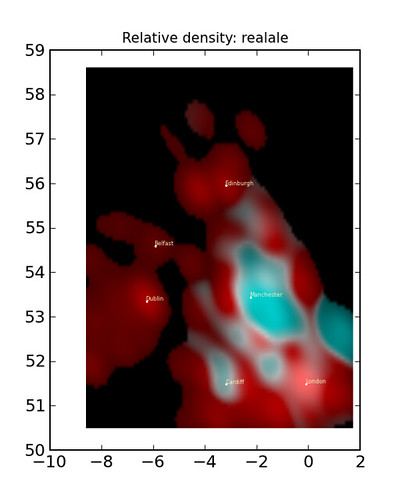
OK, if you want to know where in the country has good pubs, how do you do it? Well, here’s what I do: download a data extract of all the pubs in the UK/Eire from OpenStreetMap, and use density estimation to look at the distribution of pub attributes such as whether it serves real ale, or food, or has wifi. That’s the normal way, right?

relative real ale density

In my blog article about pubs in UK & Eire I’ve posted more plots, as well as the source code and some extra info.