OpenStreetMap logo OpenStreetMap

migurski's Diary

Recent diary entries

If you’ve ever wanted to help build the OpenStreetMap website but found our codebase intimidating, you’re in luck. With the recent addition of Jamie Alessio’s Docker support in pull request #2409, it’s now easier to contribute well-tested changes to the OSM site. I’ve never been comfortable with Rails, Chef, or other Ruby code like the kind we use to build OSM.org. Many helpful changes to the site can be made with small front-end tweaks in just HTML or CSS. The new support for Docker provides a quick way to install a working version of the OSM site on your local computer and preview changes before you contribute.

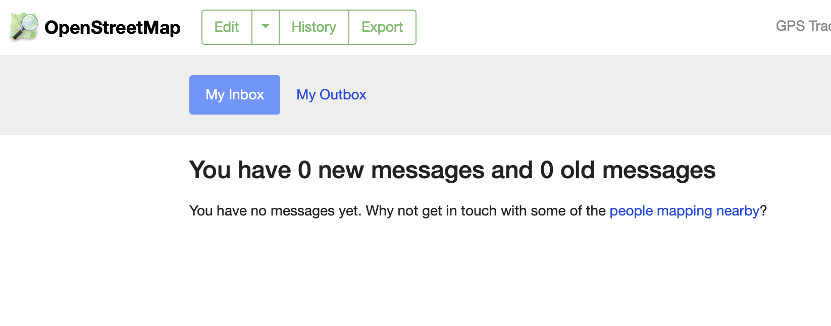
Here’s a recent change I made to implement Andy Allan’s suggestion for improved inbox/outbox navigation, using Bootstrap navigation tabs in place of plain links. This small design tweak is now live on OSM.org My Messages:

new Inbox image

Contrast this with the old look, with simple HTML links in the page header that don’t quite look like usable navigation:

See full entry

Location: Downtown, Downtown Oakland, Oakland, Alameda County, California, 94612, United States

This post is a followup to yesterday’s maps of OSMF 2021 Survey results. We looked at demographics of survey respondents and their feedback to the board on 2020 actions like establishing new committees and fundraising.

I’ll start with a recap of survey respondents vs. the general editing population of OSM. Jennings Anderson also posted yesterday with a view of worldwide mapping behavior and a simple methodology for determining who’s a local mapper for each survey region. This first map shows the number of survey respondents per 1k local OSM mappers, ranging from fewer than 10 in Indonesia and the Middle East to 35+ in Belarus:

xxxxx

See full entry

Location: Downtown, Downtown Oakland, Oakland, Alameda County, California, 94612, United States

Summary Maps of OSMF 2021 Survey Results

Posted by migurski on 26 February 2021 in English.

OpenStreetMap’s 2021 survey wrapped up just over ten days ago, and the Board has posted summarized results on the Wiki. The geographic survey responses are aggregated to preserve anonymity, in some cases grouping dozens of countries under a single region. The maps below show simple survey results using the Board’s country-to-region mapping to make the responses easier to interpret.

All maps below should be considered “No Rights Reserved,” CC0, or public domain.

Mappers

Let’s start with the mappers. The majority of survey respondents worldwide agreed that the term “mapper” described their involvement with OSM:

“Optional Demographic: Are you a mapper?”

To re-create the map above, and all other maps in this post, source tabular data, region GeoJSON, and a QGIS file are available in a Github gist.

Jennings Anderson posted earlier today with a view of worldwide mapping behavior to put the above results into context. He provides a simple methodology for determining who’s a local mapper for each survey region:

See full entry

Location: 37,804, -122,271

I’m Running for OSMF Board

Posted by migurski on 30 November 2020 in English.

I’ve made OpenStreetMap a major part of my life and work since 2005. It’s not just an audacious, community-built, complete, freely-licensed, street-scale map of the world. OSM is also a big tent that collects the skills and support of a huge range of individual and organizational contributors.

In 2021, OSM’s community has two opportunities to grow stronger together: we should make the OSM organization support a wider diversity of participants and we must succeed at starting to manage our technical operations professionally.

I’m a good candidate to help with both of these existing 2020 OSMF board goals. As a product and engineering leader in several organizations, I can help the Foundation succeed at finding and keeping great engineering talent. With my history on the community and business sides of OSM, I am experienced in making open data attractive to new community members and soliciting support from large organizations.

I’d like to make myself available for conversations with anyone who has questions about my candidacy, manifesto, priorities, or really anything else. I’m blocking these four times over the next two weeks prior to the close of voting and AGM on Dec 12; get in touch here or via my personal email if you’d like to chat by text, voice, or video!

Read my complete manifesto on the Wiki for more about why I think I’d make a good OSMF board member.

Location: Longfellow, North Oakland, Oakland, Alameda County, California, 94609, United States

Daylight’s Fourth Release and New Website

Posted by migurski on 26 September 2020 in English.

Facebook is releasing an update to Daylight, our complete, downloadable preview of OpenStreetMap data.

📥 Download Daylight Map Distribution right now in OpenStreetMap PBF format: 📦 planet-v0.4.osm.pbf (59.5GB).

Version 0.4 marks the first of our expected monthly Daylight releases through the end of 2020. With this release, we are including new coastline data, updated Microsoft ML Building Footprints data, and for the first time we’re including data about specific features we’ve excluded from a Daylight release.

There’s also a new site with a machine-readable feed of future Daylight releases: DaylightMap.org.

Read the complete announcement here.

Daylight Map Distribution

See full entry

Location: Downtown, Downtown Oakland, Oakland, Alameda County, California, 94612, United States

Facebook is releasing a third update to Daylight, our complete, downloadable preview of OpenStreetMap data.

📥 Download Daylight Map Distribution right now in OpenStreetMap PBF format: 📦 planet-v0.3.osm.pbf (57GB).

Earlier this year, Facebook released Daylight as part of our work with OpenStreetMap. We use maps to let our users find friends, businesses, groups and much more. OpenStreetMap (OSM), the open source wiki map, has a substantial global footprint of map data built and maintained by a dedicated community of global mappers making OSM a natural choice for Facebook.

Every day, our mapping teams work to confirm OSM’s millions of community contributions for consistency and quality by excluding intentional and unintentional edits that are incompatible with our use cases. Daylight is the result of that process.

Daylight Map Distribution

See full entry

Location: Downtown, Downtown Oakland, Oakland, Alameda County, California, 94612, United States

Facebook is releasing an update to Daylight, our complete, downloadable preview of OpenStreetMap data.

📥 Download Daylight Map Distribution right now in OpenStreetMap PBF format: 📦 planet-v0.2.osm.pbf (56GB).

Earlier this year, Facebook released Daylight as part of our work with OpenStreetMap. We use maps to let our users find friends, businesses, groups and much more. OpenStreetMap (OSM), the open source wiki map, has a substantial global footprint of map data built and maintained by a dedicated community of global mappers making OSM a natural choice for Facebook.

Every day, our mapping teams work to confirm OSM’s millions of community contributions for consistency and quality by excluding intentional and unintentional edits that are incompatible with our use cases. Daylight is the result of that process.

Daylight Map Distribution

See full entry

Location: Downtown, Downtown Oakland, Oakland, Alameda County, California, 94612, United States

Announcing Daylight Map Distribution

Posted by migurski on 10 March 2020 in English.

Facebook is releasing a complete, downloadable preview of OpenStreetMap data we plan to start using in a number of our public maps.

📥 Download Daylight Map Distribution right now in OpenStreetMap PBF format: 📦 planet-v0.1.osm.pbf (42GB).

At Facebook, we use maps to let our users find friends, businesses, groups and much more. OpenStreetMap (OSM), the open source wiki map, has a substantial global footprint of map data built and maintained by a dedicated community of global mappers making OSM a natural choice for Facebook.

Every day, OSM receives millions of contributions from the community. Some of these contributions may have intentional and unintentional edits that are incompatible with our use cases. Our mapping teams work to scrub these contributions for consistency and quality. In the course of this work, we also build additional tools and technologies on top of OSM.

OSM is a complex data product. Many tools, services, and companies have been created to make it full-featured. We’ve always developed our OSM-related tools with the hope that our approach to keeping maps current and accurate for our own use cases may also benefit others in the OSM community. To that end, we’re pleased to announce the release of the Daylight Map Distribution, one of our internal OSM datasets scrubbed to meet the quality standards of our wide-ranging products.

See full entry

Location: 1 Hacker Way, 1, Menlo Park, San Mateo County, California, 94025, United States

I’ve been trying some light contributions to OSM’s Chef repository. In the OpenAddresses project we learned early that reliable and responsive continuous testing and integration make it easier for contributors to approach our project, and I’m hoping to build similar tests for OSM Chef. We already do a basic syntax lint, but these new tests would run each complete cookbook on a clean disposable host and notify Github of the results:

kitchen test --parallel --destroy=always all && notify-passed || notify-failed

Contributors would see an additional green check-mark in their pull requests, and OSM admins would be able to accept contributions confident that they’ve been fully tested.

Why Mess With Chef?

I’ve been in a long conversation with Andy Allan about small ways to help with OSM’s operational infrastructure. He nudged me in the direction of OSM’s Chef configuration, which shouldn’t be a surprise: Chef is how OSM manages the configuration of all the servers run by the OpenStreetMap Foundation’s Operations Working Group. Contributions to Chef are specifically cited in Andy’s Getting Involved post and mentioned in policies for both the Operations Working Group (OWG) and the Sysadmins group.

Andy recommended that I pay special attention to the Wiki cookbook: it’s the system that has the most outside interest from non-sysadmins over the last three years. For people who would like to change the configuration of wiki.openstreetmap.org a working cookbook would make it easier to test locally with test-kitchen and offer contributions that are known to work prior to deployment. Today, “we only find out if the changes actually work when we run them on the live servers.”

See full entry

I’m Running for OSMF Board

Posted by migurski on 5 December 2019 in English.

I’ve made OpenStreetMap a major part of my life and work since 2005. I love the sparkling audacity of a complete, freely-licensed, street-scale map of the world built from the ground up by a community motivated to share work for collective benefit. Living in the United States I know firsthand the benefits of high-quality free public data like we get from the US Geological Survey and Census, and OSM promises to extend this benefit to the whole planet.

OSM for me has always been a story of global impact through work: at Stamen Design I led our participation in open mapping with a mix of early San Francisco mapping parties, paid clients, and experimental projects. Some, like Field Papers (presented as “Walking Papers” at SOTM 2009 in Amsterdam) helped OSM become a force in humanitarian mapping and have since matured into useful infrastructure. I’ve helped OSM US since its first conference in Atlanta in 2010 and served a term on the US Foundation board in 2012. In 2016, I coined the term “craft mapping” in a widely-read and commented-upon blog post to tell a story about the contrast between OSM’s hand-made history and its potential utility future. OSM’s greatest strengths are its worldwide reach, open contribution model, and free license. I have recently grown so excited by the large-scale use and expansion of OSM that I joined the Facebook mapping team last year to contribute to our OSM efforts.

Read my complete manifesto on the Wiki for more about why I think I’d make a good OSMF board member.

OpenStreetMap US is hiring an Executive Director, and they are looking to build a hiring committee:

We are thus inviting community members (YOU) to self-nominate if you are interested in participating in the hiring process. … If you are interested in nominating yourself, expressions of interest will be accepted by email (to hiring@openstreetmap.us) until January 12th, 2018.

I’m interested, so I sent the email below.


Hello,

I would like to participate in the Executive Director hiring process as part of the 7-person committee! I’m pretty sure I know a few of the people who might be reading this email, but I thought I’d make it a more formal one to underscore my interest in helping.

I enthusiastically support the idea of finding a leader for OSM US at this time. The US Foundation has consistently been on the cutting edge of international OSM work, from hosting the most consistently well-produced regional conferences to pioneering advances in OSM’s use for disaster response and international development. OpenStreetMap needs a way to communicate with the many organizations whose mission or business depends on it, and hiring a full-time ED will help this happen.

OSM as a whole is experiencing rapid change, and faces both risks and opportunities I wrote about in this widely-shared blog post last year: http://mike.teczno.com/notes/openstreetmap-at-a-crossroads.html

As a long-time participant in open source and non-profit technology efforts, I bring experience and perspective that will help ensure a good process and result. I’m on the boards of mapping non-profits GreenInfo Network and Digital Democracy, I served as CTO of government technology non-profit Code For America for three years, and I’m currently Executive Director for a new non-profit political mapping project, PlanScore.org.

See full entry

Location: Longfellow, North Oakland, Oakland, Alameda County, California, 94609, United States