OpenStreetMap logo OpenStreetMap

mikelmaron's Diary

Recent diary entries

HOT 2015 Year in Review

Posted by mikelmaron on 31 December 2015 in English.

That time of year again … take stock of my year in HOT. Started off the year as a Presidential Innovation Fellow at the State Department working on MapGive, supporting HOT from the US government side. End the year working at Mapbox, still supporting HOT!

At State, got to help facilitate some truly remarkable collaborations. Nepal was a huge focus for all of us. I worked a lot on coordination, imagery, communications, especially within the USG. Worked with a great group of people to increase cooperation among institutions in OSM. We helped formed a Open Government Commitment to OpenStreetMap, with a great showing at the OGP Summit in Mexico City.

Was part of the team that put together an incredible, inaugural HOT Summit. What an incredible event. Got to tell a story of some of the early HOT history. Started off that week lending a hand with HOT Activation Curriculum Sprint.

Spent time on the Governance Working Group, putting together Bylaws updates. We now have 2 year terms for Board members! Lots more to do.

Sadly saw Kate depart as ED, but warmly welcome Tyler. There’s been a super skilled group of folks volunteering and working with HOT over the year, and happily talked with them about various things. What an amazing year — Tanzania, OpenAerialMap, Export Tool, and everything else I’m missing.

At Mapbox, we made a public commitment to HOT, which I hope is a model for other organizations supporting HOT. We matched the first 10k of the HOT fundraiser.

What about 2016? I’m going to keep volunteering on the Governance WG, we have work to do. Also interested to connect up more with HOT Training and education efforts. I’m on the State of the Map WG, and think we could pull off a great HOT Summit adjacent to it in Brussels. I’m very interested to invest time in local organization capacity, and hope efforts with Local Chapters in the OSMF (where I am now on the Board) can help with that.

Recently learned there is a new real estate development in the early stages of planning in my neighborhood. The Josephite’s Seminary has over a block of undeveloped space, and they’ve entered into agreement with EYA to build townhomes on the property. The number of townhomes being discussed is 150, a higher density of development than the surrounding neighborhood.

screen shot 2015-12-30 at 8 48 51 am

imagery: © Mapbox, Digital Globe.

I had a hard time picturing how 150 townhomes could fit on the site. EYA hasn’t yet come up with detailed plans, and has stated that they want to work with the community in the design phase. I am also interested in how maps could help the neighborhood envision ideas for what they want for the development.

See full entry

Location: Michigan Park, Ward 5, Washington, District of Columbia, United States

I am excited to put myself forward to serve on the OpenStreetMap Foundation Board. I’m a mapper, coder, communicator and organizer, obsessed with OpenStreetMap for over 10 years. The OSM community has grown phenomenally. The core governance of OSM, the OSM Foundation, has kept the core resources of OSM stable and strong, but has struggled to keep up with the community. OSMF needs to grow. Growth doesn’t necessarily mean get bigger; I believe within our community we have everything we already need. What it does definitely mean is getting smarter and faster about how we engage and collaborate together beyond the map. That means creating proper space and structure in OSMF for a much broader diversity voices and activities of the OpenStreetMap community. I have a strong record of building alliances and networks in the OpenStreetMap community, and am ready to bring my efforts to OSMF.

OSM is a global project, and participation in OSMF should reflect that diversity. Local Chapters are a critical means to bring more voices and energy into OSMF. Local Chapters are national and local level groups of OSM mappers, some more formalized than others. We should engage Local Chapters (whether officially signed up with OSMF via an agreement, or more nascent) to broaden our discussions and deliberations, and recruit more help for the critical activities of the working groups. We can help Local Chapters do what they do better, with support for community management, events, and organizational capacity. Linking chapters together to share their knowledge benefits everyone. I’d help kickstart this, through targetted discussions through Local Chapters, on what they hope to see from OSMF and OSM.

See full entry

HOT 2014 Year in Review

Posted by mikelmaron on 5 January 2015 in English.

I started my HOT year a worried president of the HOT Board, and ended as a confident regular member.

We all worked hard. Really hard. Most importantly on HOT activations and projects. HOT has had a stunning impact on humanitarian response. But we knew we could this. What challenged us more was ourselves. We worked hard on HOT’s organization, the processes and relationships that make the space for amazing to happen.

Ok, let me just say personally, I had a lot to learn this year. I’m not proud of everything I did. But I’m immensely proud of where HOT is now.

The Board Face to Face was a real turning point. Sincere thanks to the Board for putting our all into this. And thanks to our guide Gunner.

Some other things I spent time on: helped coordinate to get V2 of the OSM Tasking Manager developed; formalized imagery coodrination; put together trademark applications for HOT; formally employed our Executive Director.

I joined the US government for a year, and really just getting started. My HOT 2015 orbits around this. Since I’m no longer on the Board, I’ll have more time to put into working groups, community building, technology.

Today, it can finally be said, I am a Presidential Innovation Fellow at the State Department working on OpenStreetMap for Diplomacy.

This is very exciting, and honestly a bit boggling, how it’s all turned out.

9 years ago, I was living in Brighton, UK, and travelled to Nottingham for several days of hacking with some very creative technical people. Invitation was from Ben Russell, “author” of the Headmap Manifesto (read this). Ben was a kind of hero to me, so that was great, and we spent a lot of time with Steve Coast, I built a slippy map for OpenStreetMap. We blew our own minds. Ben summed it up … OpenStreetMap was going to totally succeed, or fail spectacularly.

The people I’ve met through pursuing this crazy dream of OpenStreetMap, the adventures, the real places opened up … I won’t even try to sum up how this project has taken over my own life, and changed the whole world for the better. Just this. When we first started talking about OpenStreetMap for Disasters, the response was sometimes polite, often condescending, and always bewildered. Today, Humanitarian OpenStreetMap Team (HOT) provides geographic data direct to the ebola response. We didn’t ask permission, but believed, listened very carefully, kept working, and created something entirely new.

See full entry

Moabi at State of the Map US

Posted by mikelmaron on 17 April 2014 in English.

Update: we had an excellent time at SotM-US and the Sprint day. The presentation slides and video are now posted.

The Moabi development team is excited for State of the Map US this weekend. We are sharing a preview of the new Moabi (to be fully launched on Earth Day), and presenting our work on Sunday at 4pm, OpenStreetMap as Infrastructure, sharing the stage with the USGS National Map Corps project, and NPS Park Tiles. Hope to see you there! And if you want a demo any time this weekend, find one of the team, Sajjad, James, Leo, Chippy (virtually) and myself.

First why Moabi?

Moabi-DRC is an independent mapping initiative that collaboratively monitors land use in the Democratic Republic of the Congo. Our community works towards a more Transparent, Equitable, and Sustainable future for the environment and people of DRC. You can use Moabi DRC to explore, share, and create projects on a wide range of issues from REDD+ to community mapping and more.

Why OSM as Infrastructure?

OpenStreetMap’s render stack, editor and web application can be used to power collaborative mapping efforts beyond OpenStreetMap. OpenStreetMap’s software is unique and powerful as infrastructure for building communities of contributors. What happens when OpenStreetMap software is reused for new data sets and communities beyond OpenStreetMap.org?

We’ve been working on customizations like…

Preset Editor for iD

See full entry

Running for the HOT Board

Posted by mikelmaron on 21 February 2014 in English.

I’m running again this year for the HOT Board, my third election. I sincerely ask HOT Members for their vote and the opportunity to serve them in a fourth year on the HOT Board.

My history with HOT is now getting long, and my dedication to HOT stronger than ever (not difficult, with HOT more amazing than ever). I appreciate Robert Banick’s nomination and touching on some of that. I’ve also recently told the story of my HOT Year, including my time spent directly on HOT Board, which as Heather illustrated, is a substantial time commitment. While it’s varied recently with time off for my family, pretty fair to say that I voluntarily dedicate 20% of working time to HOT.

So like many of us, I have so many ideas for HOT, it’s hard to know where to start. Here’s my priorities for myself over the next year, touching on where I think HOT needs to focus and grow.

Raised many times in discussion lately, our Bylaws need to be updated, to better reflect the shape of our community, and clarify ambiguities. I led the process of developing the HOT Code, and am ready to facilitate the process with all interested members for the Bylaws.

Connected, there are many HOT processes sitting collectively in our heads, that don’t need to be enshrined in the Bylaws, but would be good to get these out objectively for us to better coordinate, in lightweight documentation. One recent example, would be a guidelines for administration of the tasking manager. We don’t want to over proscribe the process, but as quickly and clearly collectively illustrate the minimum we need to know.

Building on that, the HOT Guide is something I’d like to help move to first version. Ourselves as members, our broad volunteer community, we all have so many skills to contribute, many outside the usual line of the mapping we do so well. Making it easy for everyone to find ways to contribute to HOT is what the HOT Guide is about.

See full entry

My HOT Year

Posted by mikelmaron on 5 February 2014 in English.

We’ve just seen a phenomenal group of folks join, the Humanitarian OpenStreetMap Team. And along the way, we are reading excellent stories from the nominations and new members recounting their personal HOT history, wonderful to learn about new folks and familiar faces.

HOT has adopted a long awaited Code of Conduct, and that’s planned to be ratified as part of the upcoming Annual Meeting and Board Election. The Code makes clear how HOT membership operates, the rights and responsibilities that come with membership. Membership signifies another level of dedication to the incredible work of our community. One detail there is our expectation to share publicly our yearly contributions, for our quick growing and widely dispersed community, and for all partners and supporters, to have a window into our HOT lives.

At the end of each membership year, members will be asked to document their contributions to HOT over the past year, and their aspirations for the next

So here’s My HOT Year. It got kinda long.

HOT Board

See full entry

GeoGit and GitHub Geo

Posted by mikelmaron on 26 September 2013 in English.

As I’ve been exploring the OSM rails app for other data, Git has hovered in the background of my thoughts, and I’ve been watching GeoGit and GitHub Geo Features closely. The conceptual basis of Git, distributed version control, solves issues we come up against regularly in OpenStreetMap, like how to keep an “authoritative” data source and community data in sync or how do we support offline editing, in areas with bad or non-existent net (something to explore with BRCK perhaps). As Jeff Johnson says, “OSM is a geodata repository with just a single branch”.

GeoGit

Chris Holmes gives a thorough recap of BoundlessGeo’s rational and work so far with GeoGit (part 1 part 2) including experiments with using git itself. Git is built around managing revisions of individual files, and hits performance issues with very large files, or very large numbers of directories (which early GeoGit experimented with, using a directory hierarchy to support quad-tree indexing). So they worked to decouple Git’s set of verbs from its backend, and implement those concepts on top of spatial databases, and provide special verbs particular to interact with OpenStreetMap (or even perhaps, OSM clones). Perhaps that’s comparable to git integrating with svn.

The work looks really promising, though they are still working on the internal technical challenges, and they’ve set the bar high, to fork the entirety of OSM including all history! They’re tremendously talented, so I expect they can get there. But what then? Git without the interface and social features of github is a frustrating experience. Replicating that kind of community space for GeoGit is another tall tall order, and I expect not the first order of business for a GIS oriented customer base.

See full entry

Tags are all too human

Posted by mikelmaron on 11 September 2013 in English.

This is a short write up of a small amount of thinking and investigation of potential ways Moabi could extend and contribute to tagging tools in OSM.

Tags are all too human

Tags are the magic tools that allow OSM to happen. There’s no systematic restriction to how features are tagged. Rather it’s based on experience, convention, conversation, invention. There’s no universal representation of the world, and tags permit that. It’s messy, not always rational, sometimes absurd like horse=yes, but also mapping social facilities in refugee camps. Using the common ones becomes an exercise in crawling through the wiki. Inventing new tags is a whole other adventure.

And so is software

Though, we make it easy on ourselves, and make tools to work a little bit with tags. There are presets for editors, style sheets for rendering, analysis tools.

How are tags read and managed by software? It’s still an (impressive) grab bag.

Editors

For iD, presets are defined as json files. Each presets specifies a tag, and other tags to fill out for that feature (“fields”), as well as synonyms for search and a logo. It’s a clean representation, focusing on the “data structure”, and the collection of features is managed through github. Afaik, there haven’t been many attempts yet to create custom sets of features. The would require compiling and hosting your own version of iD, there’s no way to do it directly in the website.

JOSM presets have been around a while. It’s an XML format that defines both tags and fields for features, and sets of features in a hierarchical menu, as well as labels and layout of dialogues. There’s dozens of preset files out there, HOT maintains a set for the Humanitarian Data Model, Map Kibera has created them, tons more.

See full entry

UN Collaborates on Zaatari Camp Data in OSM

Posted by mikelmaron on 4 September 2013 in English. Last updated on 6 September 2013.

Zaatari, in northern Jordan, is facing huge humanitarian pressure from the Syrian conflict, considered the second largest refugee camp in the world. To aid the response and improve coordination of geographic data in the camp, a remarkable cooperation is underway there among UN agencies, the OSM community, and potentially, the refugees themselves.

Getting Here

As the Syrian crisis deepened, HOT was prompted to activate in January. It’s naturally proven difficult to coordinate remote mapping inside Syria, though there has been significant and interesting activity over the past two years.

See full entry

Location: B-10-03, District 10, Badiah Shamaliyah Gharbiyah Sub-District, Badiah Shamaliyah Gharbiyah District, Mafraq, Jordan

Skill Share: Map Photos Using OpenStreetMap and TileMill

Posted by mikelmaron on 14 August 2013 in English. Last updated on 27 September 2013.

Recently, we organized a fun skill share with Map Kibera, and then again with Transparent Chennai. The idea is to use OpenStreetMap and TileMill to create an interactive photo map of OSM features. Here’s the simple result from working with Map Kibera.

Want to learn to create something like this? This guide takes four steps, demonstrating an overview of the whole flow and connection between four tools to build a photo map. This guide will hit the main points, highlight how the tools connect up with open data, and I’ll just link to other resources for the details on how to use each.

Note, this guide is to create photo maps of objects mapped in OSM, not arbitrary points where you have happened to take photos.

Upload Photos to Flickr

  • What you need: A photo of a place to map.
  • What you get: Link to the photo page and photo preview.
  • Learn more: Flickr Help

If you don’t have a Flickr account, create one, it’s an easy way to share images. Upload a photo of a place. For our example, we uploaded this photo of the iHub in Nairobi, taken during the Uchaguzi election project. We created a Map Kibera group to hold all our collective photos. MK mappers get in touch with me directly if you need access.

See full entry

I’ve begun technical advising on the next iteration of a collaborative mapping project, to collect, discuss and disseminate data and stories on deforestation in Democratic Republic of Congo. I first began thinking about it over a year ago, with this write up on Moabi and GeoWeb challenges, and have since helped WWF iterate on the old platform with Sigaptaru. Right now, I’m at the offices of IIASA, a global scientific research institute situated outside Vienna, in a castle. A few weeks from now, I’ll be in Kinshasa, challenging most all of my assumptions about the project.

Right now, I want to challenge some of the technical direction this project is taking, and I hope you can help. I may be in danger of seeing every map through an OpenStreetMap lens; though it’s possible I may be on to something.

Naturally, I want this project to be based on existing, active open source projects. Architecturally, we favor focused components integrated through appropriate data sharing and APIs, over a monolithic system. In Moabi, this means good functional separation between data management, and exploration presentation and communication, with links back to dig in if desired. We’ve starting talking about this as the difference between the kitchen and dining room (though our kitchen would be open plan, and anyone can come in and cook. The analogies are endless). There are groups of folks already collaborating on creating and sharing DRC data, but “bilaterally” and without a full community or tool for coordination. The data collected in Moabi is relatively specialized, like details of mineral right concessions, REDD+ project boundaries, field surveys, artisanal logging sites, proposed road projects, etc.

See full entry

Location: Laxenburg, Bezirk Mödling, Lower Austria, 2361, Austria

What a fantastic State of the Map US

Posted by mikelmaron on 12 June 2013 in English. Last updated on 13 June 2013.

It’s hard to know where to start. Most of the last four days, I wanted to be in at least three places at once.

Top of my agenda was moving forward the discussion and building of social tools in OSM, many of us were thinking the same, and we truly did make progress. Thanks so much for the great reception to the ideas in my presentation, and also happy for the interest in the slice of the early “history” of OSM. Talks by Saman, Richard, and Martijn all gave different approaches to a common vision, and I think there’s broad acceptance of the direction in the OSM community. We got to work at the code sprint, on a two sided approach. Martijn, Steve Singer, Drew Dara Abrams, and Tom all contributed to the basic framework of Groups in the rails port. And Serge and Drew did some good exploratory architectural thinking into an Activity Server (OSM Antenna) to support News Feeds. I also started off on a more expressive User Profile page, including linking in JSON from HYDC (hoping to get JSONP). Lots of fun to be part of this and other ad hoc dev teams, and I really want to find ways to keep the pace on this and other development efforts.

Related were several good discussions on improving the community outreach and community tone of OSM. Alyssa Wright’s investigation of gender and list participation totally hit home, and some solid ideas to address this imbalance are in formation. Also, think I recruited a couple new list moderators (Tom, Stephen, I’ll be in touch!).

See full entry

Location: Mission Bay, South of Market, San Francisco, California, 94158, United States

Devouring the Landscape

Posted by mikelmaron on 3 April 2013 in English.

The weather in DC last Saturday was forecast to be warm and bright, and it was. I was desperate to escape the city, see expanses of budding trees and returning migratory birds, and have been planning for nature on my phone, digging into the NPS Chesepeake Explorer App since I stumbled onto the Star Spangled Banner Trail on the way to the Hyattsville Mapping party. It’s a nice app, I hope they update soon to use NPS Park Tiles.

See full entry

Location: Sandy Hill Acres, Prince George's County, Maryland, 20769, United States

StudioX Mapping Party

Posted by mikelmaron on 7 March 2013 in English. Last updated on 20 March 2013.

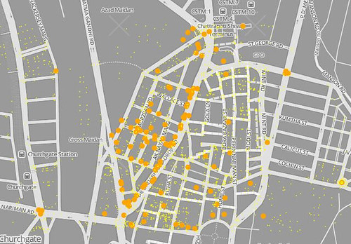
Last month, we held a great mapping party in Mumbai. I was in town for TechCampMumbai, and had introduced OpenStreetMap and discussed how to use open source tools with dozens of South Asian civil society organizations. Overwhelming and inspiring, lots of grassroots potential, worthy of several more posts. However, we didn’t get to do much mapping (except for adding the outline of our very nice hotel), so I was eager to get out in the city.

map of new data from the party

Good friends from ChaloBest and the OSM India community pitched in to bring something together at the very nice space of StudioX, and invite interesting civic minded folks like Walking Project to come out to learn the tech and community. I had also extended the invitation to all the TechCamp attendees, and the Bangladesh contingent came through on their tourist tour of south Mumbai (most everyone else had immediately left after the camp concluded the night before).

See full entry

Location: A Ward, Zone 1, Mumbai, India

(Not) Finding Communities

Posted by mikelmaron on 15 February 2013 in English.

I often get asked for connections to local OSM mappers and communities, or a listing of countries in a region with strong OSM presence. Depending on the place, sometimes it’s easy, sometimes it’s hard.

Today, I was asked about Jordan. It’s proven hard.

That’s a place where I have a little direct experience (http://brainoff.com/weblog/2010/02/26/1532) and some history of direct connections. I know there hasn’t been a strong local effort, but there have been a few individual locals, and some interesting events. So I went about trying to finding people.

First stop OSM History Tab. This quickly proved useless as mostly it captured recent, big, global efforts.

I then tried the beta OWL History Browser. This work has been lately pushed by Pawel, with some UI ideas from MapBox, and building on the infrastructure developed by Matt Amos. It’s looking awesome, and I hope that the hard last steps to make it production ready get a push soon. As of now, it’s offline, so no use for my current needs.

Then over to ITO Map. I created an area for Amman, and it created a nice visualization of the top mappers. Clicking through to their OSM profiles, I can see their details, and the history of the mapping. Turns out the top mappers are all foreign, tracing from imagery globally; which is awesome, but not helpful for local community connection. A dozen folks down, and someone who looks to be local, though inactive. One gap here is that ITO is created statistics only for the last revision of every object in the area, not for all time; so it doesn’t pick up the historic top mappers. I think that the license redaction hit this area hard, so there has been a lot of remapping. (correction: lyx, who’s been heavily involved remote mapping, says that Jordan wasn’t hit hard by redaction bot, just never much data to begin with)

See full entry

National Park Service Mapping

Posted by mikelmaron on 4 February 2013 in English.

At the mapping party in Hyattsville a few months ago, I stumbled apon and mapped part of the Star Spangled Banner Trail, a National Park Service Historic Trail covering sites throughout the region. Gave me the idea to organize a mapping party around the trail, and maybe coordinate with the NPS. I’m a history geek, and love getting outside, so OSM is basically an excuse to explore.

So I cast out onto the mappingdc list and twitter to get in touch with some folks at the NPS who might be into the idea. Most everyone lead me to Nate Irwin and Mamata Akella. I had met Mamata super briefly at SOTM-US, simply hailing the greatness of the NPS being there; I didn’t get a chance to learn about their work then. We had a chat the a couple weeks ago, and I’m really impressed.

The NPMap team are working to create a tile set specifically designed for use by the National Park Service. Out of the box tile sets have their place, but there’s a need for maps that highlight detailed park information, in the beautiful cartographic style we know and love in NPS paper maps. Their software and data stack is familiar to us, built around TileMill. The results so far are stunning, familiar from trips to the parks, and they’re still working hard to improve the style and rendering process. And they’re documenting the process, introducing the rational for the tiles, and delving into the technicals.

Just the other day, they used all this to roll out a real time Blue Ride Highway road closure map!

See full entry

Hyattsville Mapping Party

Posted by mikelmaron on 2 December 2012 in English.

Yesterday MappingDC did a mapping party in Hyattsville, MD. Good results. Was fun catching up with DC mappers, and meeting a bunch of folks from US Census (good job Steven Johnson!). Heard fascinating project fior informal settlement mapping undertaken by US Census in colonias, along the Mexico border, in Texas where there are no zoning laws, coordinating with researchers and activists … never imagined anything like this in the US.

I biked from there from the OpenGovHub. The Sanitation Hackathon was there this weekend, exceeded my expectations largely due to learning about the Peace Corps Innovation Program and seeing some energy in the hub. This problem on mapping medical facilities in OpenStreetMap provoked a lot of ideas I’ve had on tagging in Kerala responsible tourism sites, and this problem on organizing directories of local projects linked to lots of thoughts from the Kibera Organizational Directory. I pitched the problem to finish off integration of OSM into the open source Google Crisis Map (yes cooperation between OSM and Google). There was also someone looking to do some drone work in less visited parts of DC.

Here’s my mapping ride on Strava and the changeset. Would be cool to see more stats like what you have Strava in OSM.org. With a little analysis, you could see how much time spent recording waypoints, show other active and lead mappers in the area, etc.

See full entry

Location: Ellaville, Hyattsville, Prince George's County, Maryland, 20781, United States

Dolly Sods

Posted by mikelmaron on 20 August 2012 in English.

In early August, spent three days backpacking in the Dolly Sods, a beautiful and unusual wilderness area in West Virginia. Highly recommended, especially if you want fresh blueberries in your oatmeal.

For maps, I downloaded OSM data to my Garmin. It was only partially complete. Searching, I found maps at http://www.jtphillips.com/DollySodsMaps/, good comprehensive mapping of Dolly Sods. Way back in 2004, they created maps using only GPS and open source software (sounds familiar :). I downloaded and image and printed it out for use on the trail.

After I got back I wanted to update OSM with a few of my tracks. I contacted a few of the previous mappers in Dolly Sods, as well as reaching out to the Dolly Sods Mapping site. Fantastically, John supported us using their data in OSM. To start, I converted the DollySods KML map to raw OSM data, using gpsbabel, and brought it into JOSM as a background layer, to compare to existing OSM data.

Fantastically, John was able to upload the GPS data to OSM, and then (joined in mapping!)[osm.org/user/johntrudy/edits]

At this point

  • all of the trails in Dolly Sods have been better aligned to the GPS traces and to the Bing satellite
  • trails were connected properly into a network
  • tagging is consistent
  • some data that was imported with TIGER was fixed up (removed tiger:reviewed)
  • tagged the boundary of DollySods with additional tags ala osm.wiki/Tag:boundary=protected_area
  • added Red Creek
  • adding parking areas

There’s always more mapping to do, maybe later…

  • a more comprehensive survey of campgrounds
  • add more water features
  • add trail numbers

This was great fun. Looking at the imagery after our trip was a great way to see it again. Hope I get to do more backpacking and mapping soon.

-Mikel

Location: Tucker County, West Virginia, United States