OpenStreetMap logo OpenStreetMap

mvexel's Diary

Recent diary entries

OpenStreetCam sign detection code and training data open sourced

Posted by mvexel on 16 May 2018 in English. Last updated on 21 May 2018.

Telenav created and hosts OpenStreetCam, as many of you know. OpenStreetCam now has well over 130 million images contributed in large part by OSM mappers (thanks!). We already integrate the images themselves with JOSM and iD.

About a year ago, we started an internal initiative to apply machine learning to detect important features such as signs that are captured in the images. While we haven’t rolled that out at scale yet, you can already see the results in some US metro areas such as Salt Lake City, Detroit and Dallas / Fort Worth, using the latest version of the OpenStreetCam JOSM plugin. The goal is to make mapping sign content much easier and quicker. You can, for example, filter speed detected speed limit signs to see only the ones where the way in OSM does not have this speed limit yet.

So far, the technology behind this has been internal to Telenav. This is changing today.

See full entry

Missing Roads from ImproveOSM now also on MapRoulette

Posted by mvexel on 24 April 2018 in English. Last updated on 30 April 2018.

Spanish language version

ImproveOSM is my employer Telenav’s effort to process billions of GPS points from our users and partners into actionable tasks for mappers. We currently detect missing turn restrictions, missing or wrong one-ways and missing roads. The easiest way to work on these tasks thus far was to install the JOSM plugin.

Now that we have a new version of MapRoulette, I thought it would be nice to make some of these tasks available through MapRoulette as well. This makes it a bit more manageable, because we have 80.000 missing or wrong one-ways, almost 300.000 missing turn restrictions, and almost 1.6 million missing road tiles.. To break that down, let’s start with a country-by country effort to add missing roads. I created a challenge for Colombia that you can find here. Let me take you through the process of solving a missing roads task. I use JOSM for my example. You can use iD as well, but then you can skip the steps that involve the JOSM plugins.

1. Install the JOSM plugin

If using JOSM, open the plugin preferences and search for ImproveOSM. Install it and restart JOSM. This will give you three map layers for the different types of tasks. I set the opacity for the missing roads layer lower, because the tiles can make it hard to see the imagery.

See full entry

The Telenav OSM team just released a new version of the OpenStreetCam JOSM plugin. The major new feature is the ability to show and manipulate street sign detections. Images in only a few areas are currently processed for sign detection, so it’s not very likely that you will see anything yet, but that will change over time as we catch up processing over 140 million images.

screen

To enable detections, right-click on the OpenStreetCam layer in the Layers panel, and check ‘Detections’ under ‘Data to display’. You can filter the detections by the following criteria:

See full entry

New MapRoulette beta

Posted by mvexel on 28 March 2018 in English. Last updated on 4 April 2018.

Spanish language version here

Hi all. I want to introduce the new MapRoulette version and invite you to try it. It is currently in beta and feedback and ideas for improvements are very welcome. This information also appears in the wiki section of the MapRoulette GitHub repository. You are welcome to submit issues there. I am looking forward to your feedback!

MapRoulette is a micro-task web tool for OpenStreetMap. It gives you small Tasks you can complete in under a minute to improve OpenStreetMap. Anyone can create groups of tasks, called Challenges, that the community can complete together.

This is the third major version of MapRoulette. The website has been completely redesigned and contains a lot of new features compared to the last major release.

MapRoulette 2 and 3 side by side

Here are some of the most visible new features.

See full entry

Trunk in a funk

Posted by mvexel on 6 October 2017 in English.

Here is how Wikipedia defines “Trunk road”:

A trunk road, trunk highway, or strategic road is a major road, usually connecting two or more cities, ports, airports and other places, which is the recommended route for long-distance and freight traffic. Many trunk roads have segregated lanes in a dual carriageway, or are of motorway standard.

‘usually’.. ‘many’.. Adverbs that serve to muddle the definition: I still don’t know whether a specific road can be classified as a trunk or not.

The OSM wiki has this to say:

Use highway=trunk for high performance or high importance roads that don’t meet the requirement for motorway. In different countries, either performance or importance is used as the defining criterion for trunk – see #International equivalence and Highway:International equivalence for guidance on road classification in different countries.

Hmm. Equally noncommittal. But there are reference to places where more specific references are to be found. I am interested in the United States. So let’s look there. The ‘International Equivalence’ section on the highway=trunk page says:

Surface expressway: A relatively high-speed divided road (at least 40 MPH with a barrier or median separating each direction of traffic), with a limited amount of intersections and driveways; or a major intercity highway. This includes many U.S. Highways (that do not parallel an Interstate) and some state highways. Wikipedia reference

..whereas the separate ‘International Equivalence’ page says for trunks in the United States:

Limited access highway with occasional grade level intersections, or major intercity highway where no motorway exists.

Not precisely the same, but I am starting to see a pattern. The definition of trunk, according to the people who wrote the wiki pages, seems to be a mix of technical and functional road classification:

See full entry

When I moved to the United States six years ago, center turn lanes were a new thing to me. Two Way Left Turn Lanes (TWLTL) , as they are officially called, make traffic safer on busy roads where left turns are made frequently, by offering a dedicated lane for left turns:

design Source: MUTCD

When I first started to map these lanes, there was no documentation on the OpenStreetMap wiki on them, so I just started to map ways that have them with center_turn_lane=yes, thinking that I’d revisit them later if the community came up with more sensible tagging scheme.

In 2012, infamous US mapper NE2 created a page dedicated to TWCTL, adopting the British spelling centre_turn_lane=yes. There are around 6000 uses of this tag, most of them in the United States. The page was created without much if any discussion in the US community: there is only one reference to it on the talk-us mailing list[1].

See full entry

Many Mappy Minutes

Posted by mvexel on 28 September 2017 in English. Last updated on 15 November 2017.

In my last diary, I announced that I would be restarting the virtual Mappy Hour for US / North America mappers. We had our first edition tonight and I enjoyed it very much.

Around 10 people participated. Kate Chapman from OpenStreetMap US joined us to talk about the upcoming State of the Map US conference, which is only four weeks away. We chatted about a variety of interesting topics: welcoming new members, how people become interested in OSM, membership of the OSM Foundation, hack weekends, how to best announce OSM events, and many more things.

The plan was to have this be a mappy ‘hour’ but we ended up spending two hours talking. We came up with a new name: Many Mappy Minutes. We decided to organize it about once a month. The next Many Mappy Minutes will be on November 15, at 5:30pm Pacific Time. Zoom worked well, so we will continue to meet on there: https://telenav.zoom.us/j/4084317935 . You can also dial in from a normal phone. I hope to talk to you then!

OpenStreetMap US Mappy Hours Reboot

Posted by mvexel on 18 September 2017 in English. Last updated on 19 September 2017.

A few years ago I started a bi-weekly video chat for US mappers, called Mappy Hours. They were fun and varied, with topics ranging from tagging discussions to a presentation about OpenHistoricalMap and many things in between.

Then we all got busy and the Mappy Hours stopped. I was recently reminded about them on the OSM Slack channel, and I thought it would be nice to restart them. So here are the details of the first Mappy Hour:

Wednesday September 27 at 5:30pm Pacific Time

We used to use Google Hangouts, but there were problems with that: a limited number of video participants, you couldn’t call in, plugins.. There is no perfect solution but I have had success with Zoom so we will try that. You can either download the Zoom client or call in using your phone.

Zoom link

There are local dial in phone numbers for many countries.

The topic for the first Mappy Hour will be State of the Map US. What are you looking forward to? Do you have a presentation you want to promote? Do you have ideas to make the conference even better than previous years? Let’s talk! Even if you are not planning to attend SOTM US, I invite you to attend: there will be plenty of time to talk about other things as well.

How would you map this?

Posted by mvexel on 11 May 2017 in English.

I am trying to figure out mapping complex intersections and I am a little stumped :) To completely represent all possible lanes and turns in an intersection, you would need to define:

  1. The lane layout (turn lanes, through lanes)
  2. The lane connectivity (which lane connects to which at the far end of the intersection)

If I asked you to map this intersection completely, how would you do it? Which (combination of) turn / lane tagging schemes would you use?

inters

(If you’re interested, this type of intersection is a CFI or continuous flow intersection.)

Maproulette Newsletter - March 2017

Posted by mvexel on 27 March 2017 in English. Last updated on 28 March 2017.

Here is the latest from the MapRoulette world! If you want to get this newsletter in your mailbox, you can sign up here!

featured 
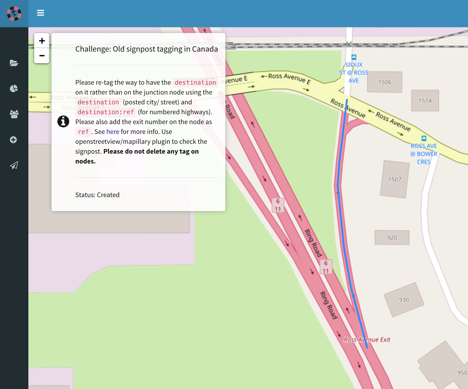
MapRoulette was featured in the JOSM message of the day!

MapRoulette has seen a lot of activity in the past month! A total of 407 mappers have logged on and fixed more than 32000 tasks. That is really cool.

New and notable challenges

Also, lots of new challenges! 539 to be precise created in the last month. I know that challenges can still be hard to discover (working on that, I would welcome ideas and help there!) so I want to just manually highlight some challenges that look interesting. If you want your challenge highlighted in this newsletter, please write to maproulette@maproulette.org!

See full entry

MapRoulette newsletter

Posted by mvexel on 9 March 2017 in English. Last updated on 10 March 2017.

Here’s the latest from the MapRoulette world!

New version released

If you head to MapRoulette.org, you will see that we have a new release out, 2.0.3. This release addresses some annoyances with the keyboard shortcuts, adds a German translation (das freut mich! Thanks nebulon42!) and cleans up the interface in a few places.

keyboard-hints

A new section displaying keyboard hints

Mapping Activity

In the past 30 days, we fixed almost 18000 tasks in MapRoulette.

See full entry

MapRoulette newsletter

Posted by mvexel on 9 March 2017 in English.

Here’s the latest from the MapRoulette world!

New version released

If you head to MapRoulette.org, you will see that we have a new release out, 2.0.3. This release addresses some annoyances with the keyboard shortcuts, adds a German translation (das freut mich! Thanks nebulon42!) and cleans up the interface in a few places.

keyboard-hints

A new section displaying keyboard hints

Mapping Activity

In the past 30 days, we fixed almost 18000 tasks in MapRoulette.

See full entry

Adding unknown roads using ImproveOSM

Posted by mvexel on 24 February 2017 in English.

When using ImproveOSM, the Telenav tool to find and add missing roads (and other missing things) in OSM, sometimes there is just no detailed aerial imagery to see exactly what road type it is.

example

While you could say, ‘Well without being able to see, I won’t add anything’. But because ImproveOSM uses actual GPS traces from drivers, you know that people have been driving there. From the image in the example you can see that a fair number of people must have taken this route, so there must be some sort of road there.

So what I suggest is to add the road as simply highway=road (generic road tag). Then you or someone else can improve it later, based on better imagery or local knowledge.

The example in the image is this new way.

Remember that you can select multiple tiles on ImproveOSM by holding Shift while selecting. That way you can more quickly mark multiple tiles as Solved.

See full entry

This post also appears on the MapRoulette wiki

Creating MapRoulette challenges has never been easier. You can use the API or the brand new Challenge Wizard. I will cover the API in a future post. I have already covered the Wizard in general in a previous post, but right now I want to focus on creating a Challenge with a GeoJSON file.

In my example case, I have a GeoJSON file containing all the bus stop locations in Utah. I downloaded these as a Shapefile from the Utah GIS portal and converted them to GeoJSON using QGIS (there are other methods too, like ogr2ogr but I am too old for that). The result looks like this:

{
    "type": "FeatureCollection",
    "crs": {
        "type": "name",
        "properties": {
            "name": "urn:ogc:def:crs:OGC:1.3:CRS84"
        }
    },
    "features": [
        {
            "type": "Feature",
            "properties": {
                "StopId": 13840.0,
                "StopName": "HILL FIELD RD @ 1891 N",
                "StreetNum": 1891.0,
                "OnStreet": "N HILL FIELD RD",
                "AtStreet": "ANTELOPE DR",
                "City": "LAYTON",
                "InService": 1,
                "Bench": 0,
                "Shelter": 0,
                "Lighting": 0,
                "Garbage": 0,
                "Bicycle": 0,
                "Transfer": 1,
                "LocationUs": "Bus Stop",
                "UTAStopID": "101001"
            },
            "geometry": {
                "type": "Point",
                "coordinates": [
                    -111.97361202442978,
                    41.08738199558664
                ]
            }
        },
...

With this GeoJSON, I go to MapRoulette. After logging in, I go to my Project and create a new Challenge. (For more details on this, see my original post on creating challenges.) I enter the basic information for the Challenge:

See full entry

`exit_to` --> `destination` in Canada

Posted by mvexel on 24 October 2016 in English.

We had a discussion about retiring the use of exit_to in favor of destination for motorway / trunk exit tagging in the US a while ago. Since then, a shift has happened and a majority of exits is now mapped with destination instead of exit_to. This is great for navigation applications that rely on detailed signpost information, such as OsmAnd, maps.me and Scout.

With the situation in the U.S. so much improved, a next obvious target for mapping is Canada :) The situation there has been improved already by the community, but also by organized mapping by Mapbox and Telenav. Still, about 1200 exits remain that are tagged with the ‘old’ scheme. With the help of my colleagues at Telenav we put these in a MapRoulette challenge.

maproulette

Because both OpenStreetView and Mapillary have good coverage in Canada, I think we should be able to update most of these exits to use the new scheme. Let’s give this a go!

Cemeteries in Texas MapRoulette Challenge now powered by Texas Imagery Service

Posted by mvexel on 20 October 2016 in English. Last updated on 21 October 2016.

Important note: The imagery I use as an example below is different in source from the imagery used for the MapRoulette imagery. The example below shows imagery that was commissioned by Texas itself, and is available in the public domain. The imagery in the MapRoulette challenge is licensed from Google by Texas and made available to MapRoulette specifically. So I can’t say positively that it’s OK to add this imagery to JOSM or iD, and removed specific instructions to do so.

Have you tried the Texas Cemetery challenge in MapRoulette? If you have not heard about it yet, I posted about it on my diary a few weeks ago. The short version: the friendly folks at TxDOT supplied me with a database of their known cemetery locations, we matched them with existing OSM, and if there was no match, we ask you to map it :)

If you tried it, you may have found though that it can be a bit frustrating :( Bing and Mapbox aerial imagery is often just not detailed enough to see if there is a cemetery or not in the location indicated. I discussed this problem with the friendly folks over at TxDOT, who are very excited about getting more data into OSM. They told me about some of the high resolution imagery that is available to the public through TNRIS, the Texas Natural Resources Information System. Here is an example of some of the amazing data they have:

See full entry

Spotting Cemeteries in Texas

Posted by mvexel on 23 August 2016 in English.

I am collaborating with agencies in Texas to update both OSM and Texas data. The pilot project deals with cemeteries. I received a file with almost 7000 cemetery locations. (Even if the idea that there are more people living today than have died thus far in human history turns out to be a myth, I think that is quite a lot!).

The first phase of this collaboration is to see which cemeteries in the Texas data actually exist. We will use MapRoulette for that. Simply go to the Cemetery challenge at maproulette.org and start looking at tasks.

If you see a cemetery in the aerial image, click ‘skip’ to go to the next one. If you don’t see a cemetery, click ‘False Positive’. If you are in doubt, click ‘skip’.

How can you tell if there is a cemetery? Sometimes it is hard. Look for fine patterns defining the plots, and usually there will be a service road connecting the cemetery to the road network. Sometimes, in larger cemeteries, you may also see paths inside the cemetery. Finally, the marker may not be right on the cemetery, so look around a bit as well. Below are some examples of cemeteries and non-cemeteries.

Once we complete stage 1, we will turn to mapping all the cemeteries that are not yet in OSM yet!

See full entry

Introducing OpenStreetView

Posted by mvexel on 15 August 2016 in English. Last updated on 24 August 2016.

After almost a year of thinking, development and testing, the OSM team at Telenav is ready to present OpenStreetView to all OSM mappers! OpenStreetview (OSV) is the free and open street level imagery platform designed 100% with OSM and mappers in mind.

We officially presented OSV to the OSM community at State of the Map US where we had a 20 minute talk and a booth where we gave away crazy little remote controlled cars to everyone who signed up :). The cars were gone quickly – almost half of the people at SOTM US signed up! - but you can still see the talk thanks to the great SOTM US organizers who had all the sessions professionally recorded. If you have 20 minutes and don’t like reading, watching that video is going to be the best way to be introduced to what OSV is and how you can use it to improve OSM. Or if you are coming to SOTM in Brussels, you can come meet our team there (more remote controlled cars? Who knows!) and attend the workshop.

booth

The OpenStreetView booth at SOTM US

See full entry