OpenStreetMap logo OpenStreetMap

spughetti's Diary

Recent diary entries

On September 26 IHE Delft and the Humanitarian OpenStreetMap Team organized a mapathon to map the areas affected by the earthquakes in Morocco and the floods in Libya.

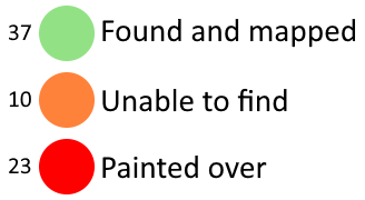
Many new mappers attended the mapathon. We collectively uploaded 813 changesets containing over 50.000 total map changes in the span of only 3 hours.

See full entry

Location: City Centre, Delft, South Holland, Netherlands, 2611, Netherlands

Importing StreetSmArts Murals in San Francisco

Posted by spughetti on 6 June 2023 in English. Last updated on 7 September 2023.

Introduction

About 2 weeks ago I found San Francisco’s open data website, on it was this dataset containing 70 murals along with information about their artist and Cultural District. I used SF Mural Arts as a source for the names of some of the murals.

I’ve uploaded all the files I used for this project here. I used a spreadsheet to track my progress, the file is called “StreetSmArts_Murals_progress.ods”. You can find way IDs in column Q and notes in column S. This legend explains what each colour used in the spreadsheet means and how many murals belong in each category. Legend to explain each of the colours used in the spreadsheet along with how many murals belong to each category. Green (37 murals) means found and mapped, orange (10 murals) means unable to find and red (23 murals) means the mural was painted over. If you are unable to see this legend you may be looking at an archive of this diary entry, please go to https://ia902608.us.archive.org/24/items/Importing-StreetSmArts-Murals-in-San-Francisco/legend.png to find the image.

Tagging Schemes

There weren’t any tags for some of the information in this dataset so I came up with some new tags in the process.

Cultural Districts

Some of these murals are within certain Cultural Districts, which from what I’ve read on their websites are basically just a fancier version of neighborhoods that organize events to celebrate the culture of those within the district.

See full entry

Location: Civic Center, South of Market, San Francisco, California, 94102, United States

Removing quantity= tags from pitches in the San Francisco Bay Area

Posted by spughetti on 23 April 2023 in English. Last updated on 1 October 2023.

I haven’t used this diary up until now, but better late than never! Figured it was time to start logging my mapping projects. :)

One of the first things I noticed when I was starting to map sport pitches in the Bay Area was the use of the quantity= tag. It was often used to map multiple pitches under one area instead of mapping each pitch individually. I’ve also seen it used to note how many of the same pitches were near each other. For example 3 basketball courts next to each other would all have a quantity=3 tag. Although I’ve seen the latter usage far less.

Mapping multiple pitches under one area makes the map less accurate, as the leisure=pitch tag is only supposed to be used for one pitch.

I’ve been fixing pitches mapped with this tag for a while when I came across them. But yesterday I learned how to use overpass turbo and now I’m able to find every pitch using the quantity= tag far more easily. I’ve been spending last night and today fixing every pitch with a quantity= tag and plan to finish fixing them in the next few hours.

Example

These 3 tennis courts were all mapped out using one tennis court area with a quantity=3 tag. In order to fix this I swapped out the leisure=pitch tag for a landuse=recreation_ground tag to turn the area into a recreation ground.

I then swapped the quantity=3 tag for a courts=3 tag, which in contrast to the quantity= tag is a registered tag on the OSM wiki.

Lastly I mapped each individual tennis court. In this case I also added a barrier=fence tag to the recreation ground.

See full entry

Location: Civic Center, South of Market, San Francisco, California, 94102, United States