treestryder's Comments
| Changeset | When | Comment |
|---|---|---|
| 57163728 | over 7 years ago | Not sure, I have had a hard time determining the best way to quickly tag a gas station. I guess I keyed off the amenity=fuel page (osm.wiki/Tag:amenity%3Dfuel ) when they say "Add a node at the centre of the fuel station". |
| 56886399 | over 7 years ago | Thanks for the edits. By the way, each of those parking lots should be changed to "amenity=parking" . For more information: osm.wiki/Tag:amenity%3Dparking |
| 56451682 | over 7 years ago | Ah... Then you will want to add an office tag.
|
| 46774105 | over 7 years ago | According to the Ingham County parcel map (http://ingham-equalization.rsgis.msu.edu/InghamParcelViewer.aspx), this property is owned by Donald Walker and I see no evidence here, at the site, folks in the neighborhood nor anywhere on the Internet, that this is a park. Could you point me to where you found this to be a park? |
| 56451682 | over 7 years ago | This looks like a house. Is it really named "SigmaCubes"? |
| 56200865 | over 7 years ago | Much appreciated. That is what I get for adding buildings using Vespucci, while eating dinner with my wife. =) |
| 55782212 | over 7 years ago | Thank you for your recent contribution to OpenStreetMap. Could you please go back through the edits you made. Some of the places that you created buildings for already had POI points. For instance, Wendy's (osm.org/way/556071194/history) The tags on the POI should be moved to the building, then the point now without tags should be merged into the building so that its history is not lost. Thanks. |
| 55792045 | over 7 years ago | What would you think of the path in Hunter Park being tagged like the River Trail (below) or possibly cycling=yes + foot=designated, as it is intended as a walking path. highway=path
|
| 55753420 | over 7 years ago | Hello!
|
| 54594075 | over 7 years ago | Thank you. It seems I incorrectly memorized that tag. |
| 54004843 | almost 8 years ago | I used OpenStreetCam for a time, then my camera developed a dead spot. Recently, after receiving free car and bicycle mounts from Mapillary, I started using their app. You should see them showing up, dead spot and dimly lit and all. |
| 54004843 | almost 8 years ago | I appreciate the addition of the exit references and destination information. |
| 54008994 | almost 8 years ago | Nice work! |
| 52996367 | almost 8 years ago | I have undone all of these changes, as they were mostly incorrect. Can I ask, what you were trying to achieve? Maybe, we could work together in the future. |
| 52969465 | almost 8 years ago | I am slowly reversing all of your changes and am working on this changeset now. Log:
Next time, please review the OSM documentation, consult the Lansing Wiki page for area standards and ask questions on the Lansing forum, particularly before making such drastic changes. |
| 52969273 | almost 8 years ago | Please look at the samples on the Lansing area wiki page (osm.wiki/Lansing,_Michigan#Highway) and reconsider some of your recent changes. |
| 12650808 | almost 8 years ago | Can I drop you a line, 5 years later? Recently, a new mapper has made many changes in the area, for the most part road re-classifications (some to your re-classifications). One change set had 75 ways changed. Willow was naively made into a "trunk_link". Any way, as you seem to have an opinion on the matter, I wondered if you might take a look at the highway type samples on the Lansing area Wiki page (osm.wiki/Lansing,_Michigan#Highway) and tell me what you think. For instance, do you still stand by your above opinion on secondary and tertiary roads in Michigan? Thank you. |
| 52969163 | almost 8 years ago | Welcome to OSM mapping! I believe MLK is likely a primary highway, though leaving it as a secondary highway would have been fine. Please refer to the Highway designations (with Lansing examples) found on Lansing's Wiki page.
There is also a To Do item on this page, that I could use your help with.
|
| 52969465 | almost 8 years ago | I've added these resources to the Lansing Wiki page. |
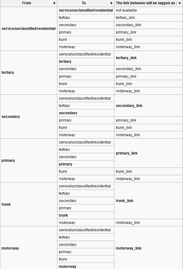
| 52969465 | almost 8 years ago | Here are two more resources: International Equivalence
Highway Linking Guide
|