OpenStreetMap logo OpenStreetMap

tyr_asd's Diary

Recent diary entries

iD development update n2

Posted by tyr_asd on 27 November 2024 in English.

My Talk at State of the Map 2024

(How the iD Editor still can to do better in the long term)

This September, I presented some ideas for the future of OSM’s iD editor at the State of the Map conference in Nairobi. Now, the video recording of the talk is online. To summarize the talk’s content: I identified two core challenges faced by the iD editor which need to be addressed in the upcoming years:

1. Data Complexity

Naturally, OSM’s data got more complex over time – as an example, a simple school might have typically been mapped as a single POI node in OSM a couple of years ago, while nowadays the state of the art is to model it using multiple map features that are nested within each other. While this allows to represent the reality in a high level of detail, the added complexity needs to be accommodated for by the tooling, especially in an editor tailored for beginner mappers like iD. For a deep dive into this topic, see also Sarah Hoffmann’s talk at the same conference.

schematic mapping of a "school" consisting of different features representing objects like the school ground, school building, playgrounds, access paths, entrances, etc.

See full entry

overpass turbo just got a new Auto Styler

Posted by tyr_asd on 3 November 2024 in English.

Attending the recent hack weekend in Berlin, I got inspired to work on a neat feature in overpass turbo. Honestly speaking, in the past few years, the tool did not the amount of attention from the developer’s (my) side that it deserves. What came clear to me at the hacking event is that a lot of people still use it on a very regular basis and that it is an invaluable part of the OSM bag of tools, which was really nice to hear.

Auto Styler (beta)

So, what someone proposed was to extend the current query wizard feature to also support the styling of the results using mapcss. What I took from that suggestion was that it should not be hard to implement a dedicated helper dialog that auto-generates MapCSS to style the data according to the values of a selectable tag and color palette. And I’m glad to say that after a quite productive two days, there’s now already a beta version already available to test out on overpass-turbo.eu.

Screenshot of the dialog of the new auto styler dialog in overpass turbo.

See full entry

iD development update n1

Posted by tyr_asd on 21 August 2024 in English.

It’s been a while since I last wrote about iD’s development and thought it would be a nice idea to make this a more regular thing in addition to the regular online community chats.

Recently, there have been some new features implemented that are worth showcasing, including several great ways that community members are stepping up to contribute to iD.

iD v2.30 release

screenshot of new Panoramax layer in iD

In his Google Summer of Code project, Mattia Pezzotti has implemented support for street level imagery from Panoramax. Panoramax is a relatively new completely free and open-source alternative to other street level imagery providers such as Mapillary, KartaView or Bing Streetside. It even includes features like a federated system architecture and the possibility to self-host the server software if you need to. Check the project out on panoramax.fr to read more and how to contribute your own pictures.

See full entry

My First Year with iD

Posted by tyr_asd on 14 February 2023 in English.

About a year ago, I started working as the maintainer of the iD editor for the OSMF. Here’s a short recap of the last year or so and a bit of outlook of what’s lying ahead according to me.

A look back

The year was characterized by the reactivation of processes which had been dormant for a little while before I started:

The tagging schema repository has received regular releases (about one major update every second month on average) after been mostly dormant in the year before. Many of the improvements to the tagging schema came in by various contributors from the community: Thanks to everyone who took part in this, including everyone actively translating on Transifex!

For iD itself, I soon learned that it is better to perform small iterative improvements, rather than tackling big reworks all at once. Therefore, my focus in the last year was primarily on stability, bug fixes and incremental improvements. There were still a few improvements to point out from last year:

  • version 2.21 switches the development build system to a more modern system based on esbuild and droped support for Internet Explorer 11
  • version 2.22 contains a first step towards making iD understand lifecycle prefixes of tags
  • version 2.23 significantly improves startup times, improved input fields in various ways and introduced a few improvements under the hood to manage presets
  • version 2.24 adds a remaining input length indicator for fields which are constrained to OSM tags’ maximum length of 255 characters and introduces a new field type for directional tags

A glimpse ahead

Another highlights of the year 2022 was the State of the Map conference in Firenze, where I spoke about the history of the iD editor (in summer 2023, it will celebrate 10 years of being the default editor on osm.org!), and tried to explain what the mid to long term high level goals are which I would like to tackle for iD. I identified five big topics to work on:

See full entry

OSM community – you're great!

Posted by tyr_asd on 11 November 2018 in English.

Normally, I blog here more about technical topics, but today I would like to take the opportunity to honor three small parts of the OSM community, who I happened to have the chance to get to know over the years that I’ve been active in mapping. All of these groups deserve a shout-out for their great work they do on OpenStreetMap month after month.

  • The OSM community in Graz (Austria) managed to map their city in great detail and keeps it complete and up to date. It was a pleasure to be a part of the monthly meetups back when I studied there. I remember many fruitful discussions over good food an a nice beer or two. Keep up the good work, guys!
  • Geofabrik is a company from Karlsruhe (Germany) which provides OSM related services since many years, some of which are available for free to the OSM community. Thank you for maintaining your OSM data extract download service, and for hosting your iconic hack weekends. You’re awesome!
  • The disastermappers heidelberg are a group of students of Heidelberg University who regularly organize mapathons and workshops, and try to raise awareness of the benefits OpenStreetMap data towards a wide audience. Don’t stop educating the mappers of tomorrow!

Do you also know groups or individuals that do great work in OSM? Let them know! :)

Latest Changes

Posted by tyr_asd on 18 February 2018 in English.

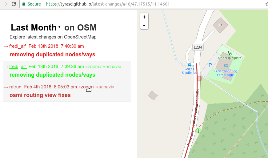
Want to get an idea about what contributions are happening in OSM in your region? Maybe you’re even looking for a way to better review map changes (hint, hint)? A good starting point is probably my latest-edits page tool. It displays all objects that have been modified during the last week alongside with their respective changesets.

One major drawbacks of the tool was that until recently, deleted map objects (and changesets consisting solely of deletions) were not displayed on the page. Now, deleted objects are displayed as faint “ghostly” outlines on the map. In the same way, you can now also see how modified objects looked like before the respective contributions happened. This can result in a nice looking “shadow” effect when for example buildings have been realigned to better aerial imagery.

Also, you can now select between the latest changes from the last day, week, or month, and directly zoom to the location of a particular changeset:

screenshot

See full entry

10 years of OSM data history

Posted by tyr_asd on 6 October 2017 in English. Last updated on 9 October 2017.

Tomorrow is the 10 year anniversary of OSM’s API version 0.5. This is the version of the OSM-API that first exposed (among other things) the version number on all OSM objects, making it possible to access the full history of every object modification from this point onward.

This means that very soon, the full history planet file published on planet.osm.org will contain more than 10 years of editing history which can be investigated, evaluated and analyzed (using tools like the OSM history database oshdb that’s currently under development at HeiGIT on the University of Heidelberg, which I presented earlier this year at the State of the Map).

Of course, OpenStreetMap as a project exists for a bit longer than that (about 13 years now) and there was already quite some data mapped before the OSM API 0.5 was introduced 10 years ago.

See full entry

Location: Neuenheimer Feld, Neuenheim, Heidelberg, Baden-Württemberg, 69120, Germany

OSM Node Density – 2017

Posted by tyr_asd on 2 July 2017 in English.

The latest installation of my yearly osm node density visualization is now online: https://tyrasd.github.io/osm-node-density shows the freshest data from mid 2017 (while the results from previous years starting with 2014 are also available on the site’s layer selection menu).

Can you guess where the following example screenshot was taken?

Click here to find out.