
ฉันชื่อ นายศรายุทธ ผุดวัฒน์ อาศัยอยู่ในจังหวัดตรัง,ประเทศไทย
Diary Entries in English
Recent diary entries

Today I started with Llëngë, a village with a population of around 75. After that I moved around in the villages in Pogradec and mapped a little here and there.
I decided to go back to my hometown and I continued mapping the city of Çorovodë, which still needs some work. I will map with EveryDoor when im there next time. Furthermore, I moved further to the village Sharovë, Prishtë, Rehovicë (which is my grandfather’s village) and finally I partially mapped Çepan.
I am sure I have forgotten some villages because today I roamed a lot on the map and I can say this Sunday started very good.
Time to translate a Wikipedia article to Albanian now. Another challenge among some Wikimedia friends.
“#100villagesin100days #day32”

I started working on a helper for OSM because I use several community-made tools, and it’s not very convenient to copy and paste links, nodes, or IDs into these tools. So, I decided to write my own userscript. This script will detect what the user is currently viewing and attach the appropriate links already prepared for the tool.
It’s a very simple script, and anyone can create something like this. However, I plan to use AI to help with tagging in the future. It began with a simple rule I used for tagging points, which made me realize I could automate it more. This will be implemented in the helper.
The helper will use Vue.js to control the interface view. In future I plan to release an extension for Chrome and Firefox.
I would appreciate any suggestions or links to web applications that might be useful.
Current releases
Embarking on the Osm Guru Fellowship was an exciting and transformative experience. This five-month-long journey focused on mapping track has provided me with a unique opportunity to enhance my skills and knowledge in OpenStreetMap (OSM). Each month presented a new task and challenge, pushing me to explore different tools and techniques within the OSM ecosystem.
The first month introduced us to the basics of OSM. Our task was to map a specific area using the OSM platform. This involved adding and editing features on the map, such as roads and building features. In the second month, we focused on collecting Points of Interest (POIs) using the Every Door app. This tool was new to me, but through hands-on exercises, I became familiar with its features. Our task was to identify and document various POIs in a designated area, such as restaurants, shops, and public facilities. This exercise enhanced my ability to gather and input detailed location data. The third month centered on using Mapillary to collect street-level imagery and POIs. We were tasked with capturing images of streets and integrating them into the OSM database. Additionally, we used the imagery to identify and add POIs. By the fourth month, our task was to create a map using the POIs we have collected before. The final month was dedicated to the validation. We were assigned to validate feature such as buildings and roads.
The Osm Guru Fellowship was a transformative experience. Each month’s task helped me develop a deeper understanding of mapping and OSM tools such as Every Door and Mapillary. I am now confident in my ability to contribute to the OSM community and use these tools effectively. This fellowship has greatly enhanced my skills and appreciation for the importance of accurate and detailed mapping.
Today i mapped the tiny village of Vlashaj in Bulqize. I also mapped a little the village Shupenzë and the surroundings.
“#100villagesin100days #day31”

Congrats to UMT as she clocks 7
Unique Mappers Network (UMT) has significantly impacted my personal and professional growth. Through my involvement with UMT, I have gained extensive knowledge and practical skills in geospatial technologies, which have been instrumental in advancing my career. The collaborative projects and community engagement activities have allowed me to work alongside experts and passionate individuals, fostering a strong sense of teamwork and shared purpose. Additionally, UMT’s commitment to open data and mapping for social good has inspired me to contribute to impactful projects that address real-world challenges. This experience has not only enhanced my technical expertise but also deepened my commitment to using geospatial intelligence for sustainable development and community empowerment.
On behalf of all those that has benefited from my knowledge and experience, thanks Unique Mappers Network
Today I finished mapping Shënepremte and I continued on the next village on the list. Xhan was a tiny village with just some houses scattered around the forest, so I mapped what I could and continued down the list to Floq.
Floq is a village in Korce with a population of around 1072. I was really inspired today so i went on and mapped also Pepellash and Helmës.
“#100villagesin100days #day30”
Today I almost mapped Shënepremte. I will keep mapping tomorrow till I finish it.
As a Linux sysadmin, dealing with an OpenSSH vulnerability can lead to a hectic day. Ensure you’ve checked your servers and updated OpenSSH if you haven’t already.
https://ubuntu.com/blog/ubuntu-regresshion-security-fix
“#100villagesin100days #day29”
I am reading through the comment log which resulted in a 10 year ban for using junction nodes incorrectly, when can they be used
osm.org/changeset/149827539#map=12/-34.8875/138.5788
osm.org/changeset/150094405#map=12/-34.8875/138.5788
these particular junction nodes are the only junction nodes ever to be deleted and removed, how are these any different to any other junction nodes on the map and why didnt the user who deleted these ones delete any other ones?
I am just seeking help with junction nodes, not sure how to use them correctly as the reason for their removal is not a direct quote from any part of the junction nodes wiki. hoping a discussion here would help shed some light on their removal.

My name is Victor, a 300-level student of the Geography and Environmental Management Department, University of Port Harcourt.
I am very excited to announce that I have joined the Unique Mappers IT Internship program.
This opportunity aligns perfectly with my love for technology and my desire to gain hands-on experience in the field of geographic information systems (GIS) and mapping technologies.
The Unique Mappers Network Nigeria is a renowned organization due to its approach and commitment to community-driven projects, making it an ideal platform for me to enhance my skills and contribute meaningfully.
I am also excited to work with a team of talented professionals and colleagues, learning from them and sharing my ideas.
Joining the Unique Mappers IT Internship is a significant step in my career journey, and I am ready to embrace the challenges and opportunities along the way.
I started my industrial training IT internship at Unique Mappers Network, Nigeria today. I’m excited to learn and contribute to the OpenStreetMap project. So far, I’ve met the team and gotten a brief overview of the company’s goals and objectives. I’m looking forward to learning more about the projects they’re working on and how I can assist.
Goals for the next few days:
- Get familiar with the company’s workflow and tools
- Meet with my supervisor to discuss my tasks and objectives
- Start learning more about OpenStreetMap and how to contribute to it
I’ll update this diary as I progress and learn more. For now, I’m just taking it all in and trying to absorb as much as I can
Today I mapped Gllavë which is a tiny village in Memaliaj.
I wandered around the map to check how this remote tiny village is connected to main streets and I found out there are many tiny villages scattered through the mountain and none of them seem to be connected (or I can not figure out how they are connected) to the main roads.
I continued mapping, and I lost count how many small villages I mapped today. I am attaching the area I mapped and if anybody knows a quick way to figure out if these villages are in any way connected to main streets can let me know in the comments.
“#100villagesin100days #day28”
Here I come to the world of OSM…. I signed up today to join Unique Mappers OSM Nigeria community and i’m so excited
NationalMap is a open and public resource, it has datasets from every state and territory.
discussion is here https://community.openstreetmap.org/t/new-nation-wide-resource-national-map-australia/115499
posting to my personal diary in-case it gets deleted from there and also for more visibility

Finally! After over four months of near-daily almost painstaking manual editing work in JOSM, entirely using aerial imagery with no automated imports whatsoever, and going through a few episodes of arm and hand cramping, all of the remaining woodland data on Vancouver Island, all the way northwest to Cape Scott, is now present in OpenStreetMap. I hope I was able to depict my own part of the world here just a bit prettier than before.
Posted by emersonveenstra on 2 July 2024 in English.
I made a Chrome extension (which should be compatible with all Chromium-based browsers) and Firefox Add-on that hooks into the osm.org Edit buttons and redirects it to Rapid. Also, it integrates Strava heatmap support into Rapid as overlay imagery.
It’s an early version, and I’m sure there’s bugs, so please open issues (suggestions welcome too): https://github.com/emersonveenstra/rapid-power-user-extension/issues
Also, for those wondering, I am jumping back into osmdiscussiontracker development soon, I just needed to scratch this itch first :)
Happy mapping!
EDIT THE CONSENCOUS HAS NOW CHANGED TO SAY THAT THIS DATA IS REMOVED BECAUSE OF A UNDOCUMENTED IMPORT WHICH IS EXACTLY THE REASON I SAID IT SHOULD HAVE BEEN REMOVED UNDER NOT BECAUSE OF A COPYRIGHT VIOLATION
The names of our beaches is open and public data in Australia, the names of our beaches have been deleted for no reason at all.
this removal was based on a unofficial chat room discussion which is not documented for anybody to see.
the surf life saving club does not own the right to the names of our beaches, however granted the the surf life saving club may not the the most direct source of this information. but we have a full waiver to use this information none-the-less from our government.
there was never a formal proposal about the removal of this information
along with this massive deletion was other information such as boat ramps and beaches drawn in clearly by using imagery.
posting here because my comments keep getting removed by the moderators now.
Woo-hoo, I just noticed I have reached over 100k Map changes!
Today i mapped the village of Mushnik with a population of 259.
“#100villagesin100days #day26”

Welcome to the thirteenth OpenStreetMap NextGen development diary.
🔖 You can read other development diaries here:
osm.org/user/NorthCrab/diary/
⭐ This project is open-source — join us today!
https://github.com/Zaczero/openstreetmap-ng
🛈 This initiative is not affiliated with the OpenStreetMap Foundation.
In case you missed it…
Last week, we showcased Search 2.0: a comprehensive overhaul of the search functionality. For the first time, OSM search is now simple and intuitive to use. It’s a must-see (there’s a video too)!
Default Editor Switching
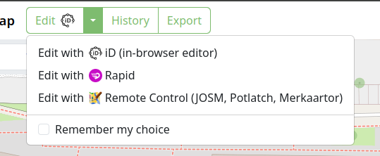
This week, OpenStreetMap-NG introduced a convenient way to change your default editor. By exposing this functionality, previously hidden in settings, we prevent editor lock-in and allow users to easily experiment with other editors. A small icon now indicates which editor is currently set as default.
Faster and Slimmer GPX Traces
We completed a major overhaul of the GPX trace database design. Here are the results: