Simbolo d'OpenStreetMap OpenStreetMap

Entrâyes du jornâl en English

Entrâyes novèles du jornâl

Publeyêe per Destiny_b lo 6 August 2025 en English.

About O’Connor & Associates O’Connor is one of the largest property tax consulting firms in the United States. O’Connor’s team of professionals possess the resources and unparalleled market expertise in the areas of property tax, cost segregation, and commercial and residential real estate appraisals.The firm was founded in 1974 and has an extensive team of experienced professionals dedicated to serving property owners.

With our proprietary protest filing system, we coordinate more lawsuits and settle more binding arbitration cases than any other tax consulting firm in the nation.

O’Connor provides its customers with property tax protest values ranging from $5,000 to $100 million. For the 2022 tax year, the firm lowered assessed values by more than $5.7 billion. The appeals resulted in an estimated tax savings of around $154 million (not including exemption data). O’Connor is one of the largest property tax consulting firms, with a team of 1,000 worldwide representing 185,000 clients in 49 states and Canada, handling about 295,000 protests in 2024. VALUES O’Connor’s mission is to be the leading property tax advocate for taxpayers and to drive reforms in the Texas property tax appeal process. Our proven solutions continue to help taxpayers reduce their annual property tax rates. We are a pioneering expert in aggressive property tax reduction. O’Connor is also a leading expert in business personal property valuation. The book What You Need to Know about Personal Property Valuation was written by Patrick O’Connor, President of O’Connor.
Luè : Houston Heights, Houston, Harris County, Texas, United States
Publeyêe per zman809xx lo 5 August 2025 en English.

Opener

Woah, I didn’t realize how quickly this would be something I’d like. I know my account has been around since 2022, but I seriously started mapping in mid-2025. ~10k Edits pretty quickly, and turns out I enjoy editing the map. Maybe I’m looking for a job around this kind of work… Who knows.

ALPR’s

Automated License Plate Readers… Man these things are poping up everywhere. I stumbled on Deflock.me recently. I don’t agree with their “Why” but, I don’t agree these things are good for society… I get that we don’t have a “right to privacy” in public spaces, but man…. this seems one flew over the coo koo’s nest. Is pervasive surveillance at this scale really that surprising? My county alone has 95 ALPR’s (mostly by flock) running 24/7/365 rain snow or shine…. That’s 1 camera per 22 sq.mi. or 1 camera per 7700 people.

Its not right…

95 Cameras over 2130 square miles, and estimated 730,000 people.
Publeyêe per yrichard lo 3 August 2025 en English.

I like technology and adapting it for the sake of technology . I am not addicted to yet we can not escape it. I only carry my phone when necessary , a computer works so much better , a mix of the old and the new ,technology moves very quickly . I’d prefer a GPS to a 5G modem ,API are not as readily available now

Luè : New Norfolk, Derwent Valley, Tasmania, 7140, Australia
Publeyêe per IsStatenIsland lo 2 August 2025 en English. Dèrriére betâ a jorn lo 3 August 2025.

https://archive.org/details/AMTK-NEC-employee-timetable-20250505-si

This is the most up to date Northeast Corridor Employee Timetable (ETT) I’ve requested, published May 5, 2025. It contains Amtrak’s maximum authorized speeds on the Northeast Corridor. The Acela 2’s planned speeds (mostly focusing on changing 150 to 160 mph) have not yet been integrated into the rules by Amtrak, despite the observed or assumed compatibility with 160 mph service by track class, catenary structure or demonstration in recent test runs. The current runs remain just that: test runs.

There are currently 4 sections of 150 mph (for Type A trains and on the “main” or “inner” two tracks) on the Northeast Corridor:

  • New Jersey: Midway & CP Clark

  • Rhode Island #1: MP 154.3 & MP 171.7, except Cv MP 159.7 & MP 160.5 and Cv MP 170.5 & MP 170.9

  • Rhode Island #2: MP 174.5 & MP 180.5, except Cv MP 180.1 & MP 180.2 and Cv MP 180.2 & MP 180.5

  • Massachusetts: MP 194.5 & MP 205

New Jersey, County & Midway is really close at 145 mph (except 3 curves) and I’m not sure what’s going to happen with that.

One of two things needs to happen before OSM can be updated with the new speeds:

  • A new ETT is issued with blanket authorization of new speeds (perhaps without even authorizing any actual train type)

  • A revenue run is observed at the new speeds

I’ve set up this tag regime to give editors a signal that the maximum speed data is extremely recent and not just based on casual observation:

  • planned:maxspeed=”160 mph”

  • source:maxspeed=”Amtrak ETT 2025-05-05”

I’ve additionally set planned:maxspeed=”160 mph” on the “between CP Clark & Ham” section as that is actually planned and possibly under construction.

There may be changes in speeds on certain curves which is why I would prefer to wait for a new ETT anyway so all changes can be done at once.

Vêre tot

Publeyêe per notmyproblem1 lo 2 August 2025 en English.

Welcome to my diary, “Where did I macro-mapped” This will be available in English and not Italian cuz: 1. I need to speak better english 2. I will (not now but not far away) wanna macro-mapping in the USA (i heard that they have absolute good imagery!) 3. Wanna move from Italy and go to Wisconsin, USA. — Where did I micro-mapped? I micro-mapped Tre Ponti Est (service plaza/rest area/or whatever you call it) look it in 3d, look it in 2d changeset I also micro-mapped the nearby service plaza/rest area, Tre Ponti OVEST, look it in 3d, look it in 2d, changeset 1, changeset 2 — (If you are looking from when I published. UTC+2 02/08/2025 23:30 or Wisconsin Time 02/08/2025 16:30, The Tre Ponti Ovest is not available cuz of cooldown aka [waiting server](https://en.wiktionary.org/wiki/waiting#:~:text=waiting%20(countable,%2C%20service.)

Luè : Faibano di Marigliano, Marigliano, Naples, Campania, 80034, Italy
Publeyêe per rphyrin lo 2 August 2025 en English.

“You’ve been involved with OpenStreetMap for at least 15 years,” the interviewers begin, marking the start of the session.

I gasp a little. Wow—15 years? Imagine all the… fights and drama?

So I get a little curious and start tracing this person’s digital footprints across the whole OSM universe. See if I can learn a thing or two.


“Upgraded road 11390 to secondary to make it stand out from all the other roads.. Because it has bus routes and stands out for transit traffic.”

“This reasoning sounds quite arbitrary to me. Also what degree of transit traffic is necessary so that the road has to ‘stand out’? General convention followed elsewhere outside of cities – and as currently documented – is to use this tag of this type and that tag for that type. The way this road stands out is now inconsistent to how other roads of these types stands out. I think it should be restored.”

“Hmm. That is a fun rule that’s easy to implement and validate. But what are you expecting to achieve with it, other than theoretical correctness – which in cartography is useless, as you might have experienced? I made it secondary, because of its heightened importance to transit traffic. So that routing engines prefer it when routing to there and not fall back on local roads. And even visual inspection would send people on it. So what would be the intention on changing it back?”

“The main benefit of mapping it to certain official classification is that this way we have a clear criteria. This official classification after all also generally indicates which roads are actually more important. If we tied tagging values to official traffic density data then probably it’d be considerably more difficult and likely the result wouldn’t be as intuitive for end users. I find that this way it’s rather difficult to decide on which highway value each road should get.”

The conversation abruptly stopped right there.

Vêre tot

Publeyêe per Ukundji lo 2 August 2025 en English. Dèrriére betâ a jorn lo 5 August 2025.

Disclaimer: This is just the start of a diary article, details about mapping objectives, progress and obstacles/questions will follow

Description of the area

The Ndomba Sector (Collectivé de Ndomba) is the easternmost sector of the Kabeya-Kamuanga Territory. While the eastern and southern borders of the sector are as well the borders of the territory (which have already been mapped for years), the western border of the sector is the River Lubi.

Roads and paths

This sector is still very remote, despite of the fact that the big City of Mbuji-Mayi and the highway Route National 1 (RN1) are close by in the south-east and south. The main reason for the remoteness is that a number of meandering rivers hinder or limit the asccess from almost all directions. The main access road from the south and from Mbuji-Mayi has been the one which leaves RN1 at 6° 06 28.3 N / 23° 26 03`` E just west of the village of Tschibombo - only 20 kilometers west of Mbuji-Mayi. This road follows the border of the watersheds of the river Mulenda (east) and of the rivers Lubi and Kagangayi (west). This way the crossing of rivers and streams is avoided for most of the distance.

Luè : Ndomba, Kabeya-Kamuanga, Kasaï-Oriental, Democratic Republic of the Congo

GSoC 2025 Midterm Update: Temporary Road Closures Database and API

Project Overview

I’m excited to share the midterm progress on my Google Summer of Code 2025 project: Temporary Road Closures Database and API for OpenStreetMap. This project aims to create a centralized platform where users can submit and retrieve real-time information about temporary road closures, enabling OSM-based navigation apps to provide better routing around construction, accidents, and other events.

  • Mentor: Simon Poole and Ian Wagner
  • Organization: OpenStreetMap
  • Project Duration: 12 weeks (175 hours)

🎉 Midterm Evaluation Status: PASSED

I’m thrilled to announce that I’ve successfully passed the midterm evaluation! The project is progressing well and is currently on schedule with several components ahead of the original timeline.

Progress Summary

Completed Components (Weeks 1-8)

1. Geospatial Database & Core Infrastructure

  • PostgreSQL + PostGIS setup with Docker containerization
  • SQLAlchemy models for Users and Closures with spatial geometry support
  • Database initialization scripts and sample data loading
  • PostGIS spatial indexing for efficient geospatial queries

2. RESTful API Service (FastAPI)

  • Complete CRUD operations for road closures
  • Spatial query endpoints supporting bounding box and coordinate-based filtering
  • Authentication & Authorization with JWT tokens and OAuth2
  • Input validation and error handling
  • Swagger UI documentation with integrated authentication

3. OpenLR Integration

  • OpenLR encoding/decoding service integrated into the API
  • Location referencing endpoints for map-agnostic road segment encoding
  • Validation endpoints for OpenLR data integrity
  • Closure service enhancement with automatic OpenLR generation

4. DevOps & Infrastructure

  • Docker containerization for easy deployment
  • Environment configuration management
  • AGPL-3.0 licensing for open-source compliance
  • Comprehensive documentation and setup instructions

Vêre tot

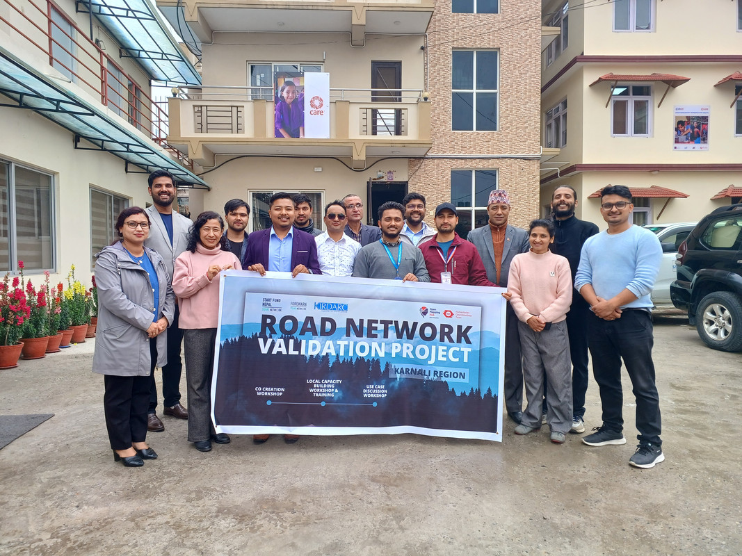
Co-Creation Workshop for Road Network Mapping in Karnali, Nepal

Date: 28 March 2024
Title: Planning & Co-Creation Workshop on Mapping Road Network of Karnali
Venue: Care Nepal, Sanepa
Organizer: Open Mapping Hub Asia Pacific
Led By: Rabi Shrestha, Sr. Field Mapping Expert & Prajwal Sharma, Jr. Field Mapping Expert

Project released for remote mapping

The rugged terrain of Nepal’s Karnali Province tells a story of resilience, isolation, and untapped potential. As the only province where road access remains severely limited—particularly in districts like Jumla—the need for a comprehensive and accurate road network is more urgent than ever. With this in mind, a collaborative Planning and Co-Creation Workshop was conducted to collectively address the challenges, gaps, and opportunities for mapping the road network of Karnali through open-source tools and community engagement.

Setting the Stage: Opening Remarks and Partner Introductions

Vêre tot

Luè : Dhobighat, Lalitpur-04, Lalitpur, Lalitpur Metropolitan City, Lalitpur, Bagamati Province, 40000, Nepal

The Nominatim QA tool added a new layer “Suspicious addr:state value”

  • If addr:state is the same addr:province. Depending on country addr:province might not be needed
  • If addr:state is the same as the country code
  • if addr:state is the same as the country name (in any language)

https://nominatim.org/qa/#map=3.52/34.84/5.81&layer=addr_state_not_country

The layer is updated every day.

Give it a go. But not USA and Canada because I was too eager and made many edits today already.

‘ve found myself drawn to a particular challenge: properly mapping the Rhondda Valleys in South Wales. It’s a task that’s proving both fascinating and frustrating in equal measure, but one that’s teaching me invaluable lessons about the complexities of local geography.

My approach has been quite straightforward - I’ve chosen to focus primarily on Ystrad, the area I know most intimately. This isn’t just because it’s familiar territory, but because understanding one place thoroughly seems like the best foundation for expanding outwards. Every quirk I discover, every mapping technique I develop, and every local peculiarity I uncover in Ystrad becomes a tool I can apply to neighbouring areas.

One of the most surprising aspects of this mapping project has been discovering just how much the “official” maps get wrong. I’ve taken to photographing street name signs and house numbers wherever I go - a habit that’s revealed some genuinely baffling discrepancies between reality and what appears on both Ordnance Survey maps and Google Maps.

The most striking example I’ve encountered is Bryn Terrace in Ystrad. This is a very real street, with real houses, real residents, and real post delivered daily. Yet somehow, it’s completely absent from both OS and Google mapping data. Walking down it, photographing the street sign, and checking my GPS coordinates left me questioning whether I was experiencing some sort of cartographic twilight zone. How does an entire street simply not exist in the digital world when it’s so clearly part of the physical one?

The house numbering systems throughout the Rhondda have provided another source of bewilderment. What might seem like straightforward sequential numbering often reveals itself to be anything but. Streets that appear to follow odd/even patterns suddenly throw in a completely out-of-sequence number, or entire ranges seem to have been skipped altogether.

Vêre tot

I wanted to share some analysis on a currently undefined part of the PWG Schema (Silver Tier specifically) that I originally posted on the OSM-US Slack. Note that this was discussed previously on the OSM forum, but the analysis here was conducted independently before reading that to.

The key question here: What footway= type, other tags and geometry (separate way from the incoming sidewalk or not) should be specified for the connector ways between the sidewalk centerline and curb nodes?

Currently, the page states only “highway=? + ?=?”; its hard to see how highway= could be anything but highway=footway as nothing else seems more suitable and inventing a new highway type would be a major backward-compat break for little benefit; therefore, the decision then would be what footway=* tag to use.

Survey of options

Surveying the possible options (with pros and cons):

Vêre tot

Publeyêe per Anton Khorev lo 30 July 2025 en English. Dèrriére betâ a jorn lo 4 August 2025.

Some websites allow users to post content with links to other sites and have previews for these links displayed alongside with the posts. Those are typically social media sites, and we’ll refer to them as “social media” in this diary entry. Examples of such sites include: - forums based on Discourse, particularly OpenStreetMap Community Forum - microblogging platforms based on Mastodon, particularly en.osm.town

There are many more of course, with some more widely known examples, such as Facebook and Twitter. We’re primarily interested in the listed above because they are directly related to OpenStreetMap.

A preview usually includes a page title followed by a longer description and an image. Typically when a submitter makes a post with a link, the social media site runs a bot to download the linked web page and scan it for metadata. The metadata usually includes textual attributes and links to preview images. The bot then downloads the images and assembles the final preview to be shown to other users.

Metadata

Here we’re interested in previews of pages on the OpenStreetMap website. Usually the links someone posts are to pages of map locations, editable osm elements (nodes, ways and relations), changesets and diary entries. All of those pages include metadata in one of the formats suitable to generate previews, The Open Graph protocol. The Open Graph metadata consists of several <meta> html elements inside the web page <head>.

The degree to which metadata on OpenStreetMap website pages allows generation of a useful previews however varies. Metadata on diary pages is usually sufficient to build reasonable previews. As an example, we can look at the html source of this diary entry:

Vêre tot

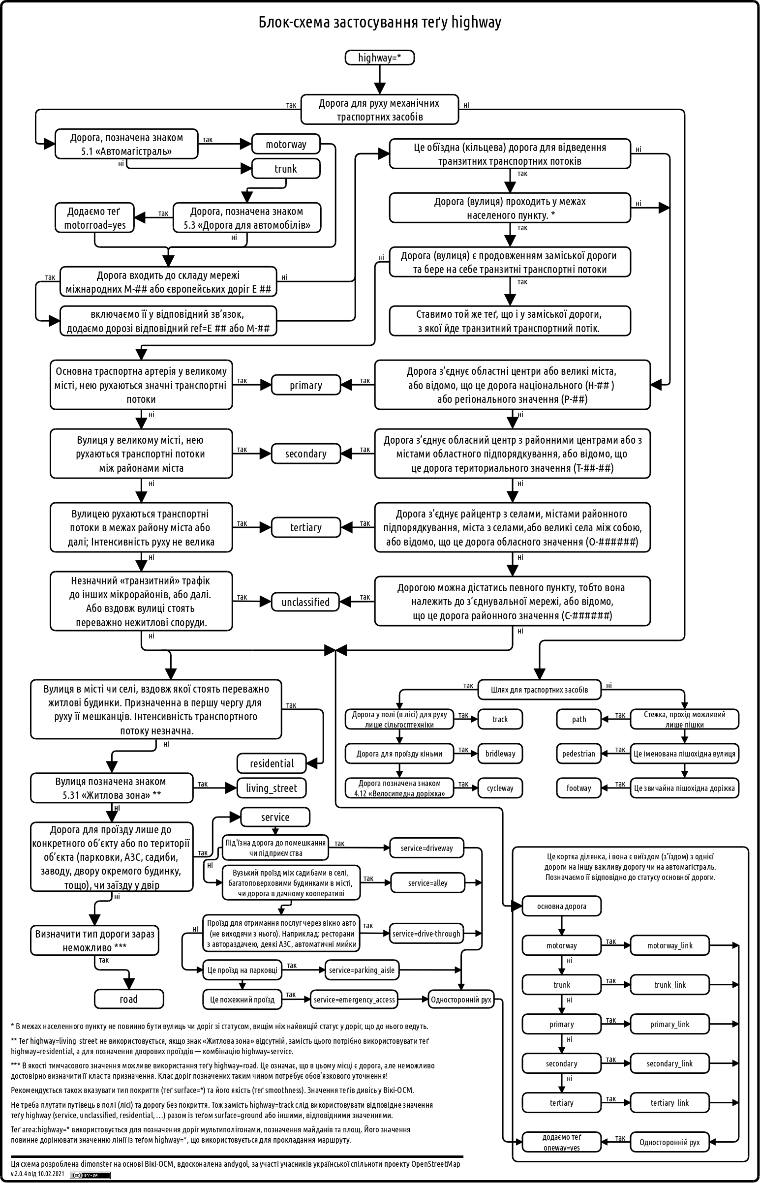
Following a suggestion by @andygol, I decided to refresh the Highway Tag Usage Scheme used by the Ukrainian OSM community. The original work on this scheme began back in 2013 — see the discussion in the Highways of Ukraine topic. I’d like to share the progress made so far and invite the community to contribute further improvements.

Previous version: Previous version

Vêre tot

There has been a recent surge of interest in mapping walking infrastructure in Melbourne. This is very exciting because many parts have been lacking for a long time.

I have been adding some things piecemeal over the years. Recently I have made a more concerted effort to get footpath and crossing data into the Map. Several other users have been doing a huge amount to make this happen.

Here I wanted to briefly share a summary of my approach to mapping these footpaths and crossings. As is custom for OSM, this is not prescriptive at all; just a description of how I am approaching this task. It is based on consistency of edits and consistency with existing and new data.

Footpaths

highway=footway
footway=sidewalk

I am also including the surface where known. Most footpaths are built of concrete, especially in older suburbs. The next most common would be asphalt, but there are still some unpaved footpaths - even in built-up areas. I think this is important to include for accessibility and route planning.

surface=concrete

One important aspect here is that I am mapping footpath ways separately to the crossing ways. Which brings us to…

Crossings

highway=crossing
crossing=*
crossing:island=*
crossing:markings=*

Here is an example of a simple T-intersection that shows my general approach to mapping ways for footpaths and crossings separately.

Vêre tot

Luè : East End Theatre District, Melbourne, City of Melbourne, Victoria, 3000, Australia

In Japan, when you buy tobaccos from a vending machine, you first have to prove that you are 20+ years old. Since 2008, The Japan Tobacconist Federation has been issuing “taspo” smart cards to adult smokers. You can apply these cards to cigarettes vending machines to activate them. Back in 2008, 97% of the vending machines supported taspo for age verification.

Due to technical limitations, taspo system was announced to be shut down in March, 2026, and some vending machines are now retrofitted with new age verification modules that accept a driver’s license card, “My Number Card” (which is officially called Individual Number Card in English), and/or passports (ref: list of government-recognized age verification modules for cigarettes vending machines).

I started to tag taspo-compatible vending machines with authentication:taspo=yes, and those with the other verification methods with authentication:JP:driving_licence=yes, authentication:JP:individual_number_card=yes, or authentication:passport=yes, respectively.