This project is created to map POIs and landmarks using field-collected Mapillary but I couldn’t find this filter.
Diary Entries in English
Recent diary entries
Learning as I go…

I started mapping a few weeks ago, sticking (mostly) to North Muirton in Perth for now as I have lived here for 50 years so I think I know it quite well. No doubt I’ll have done a few things wrong along the way but I’ll go back and fix, if and when I realise. As I write this, almost all the houses and flats in NM are at least drawn out with a few streets still to be tagged with the “basics”.
I intend to add (or finish)
- Electricity Substations (all operated by SSE? - I think they all are)
- Grit Bins
- Public Benches
- Garages (rented out by the local council)
- Add all postcodes
- Public pathways (miles of them!)
- Back fences (the 6ft high ones around all the back gardens)
- Grassy areas
- Road crossings
- Drying greens for the 8 and 4-block flats
Posted by PRISCOVIA12 on 5 October 2024 in English.
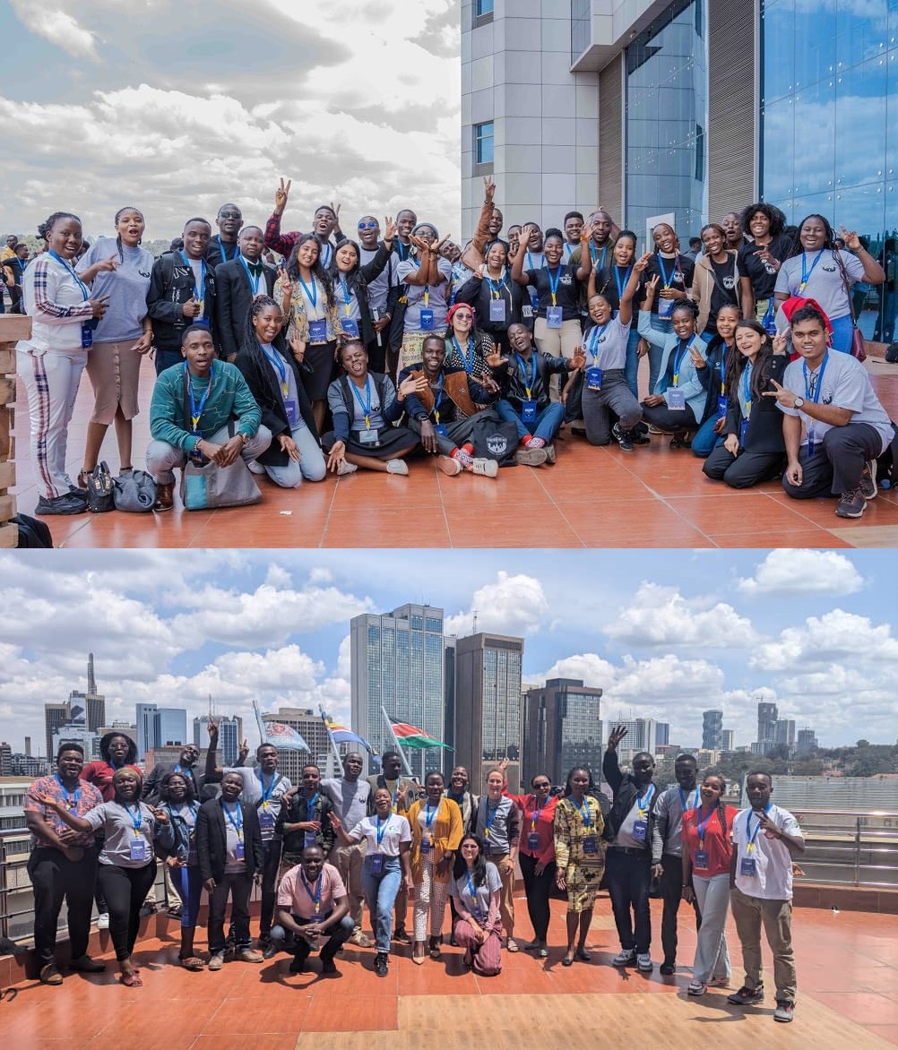
 This Conference was a Good opportunity for me and all the team from Rwanda as well as Africa in General because it was the first time of Africa to host the state of the Map.
apart from traveling from Kigali to Nairobi for 26hours in the bus ,I enjoyed every details in the conference and Nairobi.
This Conference was a Good opportunity for me and all the team from Rwanda as well as Africa in General because it was the first time of Africa to host the state of the Map.
apart from traveling from Kigali to Nairobi for 26hours in the bus ,I enjoyed every details in the conference and Nairobi.
Attending State of the Map 2024 in Nairobi, Kenya, was an unforgettable experience that deepened my understanding of mapping and the OpenStreetMap community. It was truly inspiring to be part of such a vibrant and passionate group of mappers and contributors from 54 countries. The sessions on community capacity building, disaster recovery and response, and conservation have reinvigorated my commitment to OpenStreetMap. I’m grateful to the community for supporting our initiatives on Pudussery Panchayat Mapping and the creation of a spatial flood asset database. Special thanks to OSMF for the State of the Map 2024 Travel Grant. I’m excited to continue contributing and collaborating with this amazing community. Here’s to more mapping adventures ahead!
On December 5th, 2017, I joined Humanitarian OpenStreetMap Team with the goal of making a tangible impact. Over the years, my curiosity on the HOT Tasking Manager grew, and I found myself increasingly drawn to OpenStreetMap (OSM). At first, I was overwhelmed with how to become more active and create more impact, but I soon discovered that my love for and working on the computer was my gateway. Contributing to OSM quickly became an addiction, a way to relax, a therapeutic outlet when I was feeling tired or frustrated.
Posted by UNGSC-DTLM-Ale_Zena on 3 October 2024 in English.
osm.org/relation/15736220 What to do against these deletion? I know, you’d said “oh, just revert the changes”. Teoretically you’d be right …. teoretically
Dealing with these long relation it’s not easy, unless you keep monitored and act in the first hours or in a few days
I’ll try to fix it
Something local for my first entry
Zannat Street

area fix
On November 13, 2023, Miami-Dade County’s transit agency, Miami-Dade Transit, implemented significant changes to its bus network - designated the “Better Bus Network.” These updates aimed to enhance coverage for neighborhoods and business districts that primarily serve lower-income residents. As a result, many routes and stops were altered, relocated, or removed.
To the best of my knowledge, much of Miami’s transit data on OSM was originally contributed by user drynwk around 2021. Most of their contributions have remained untouched for nearly three years, despite the major changes from the Better Bus Network almost a year ago.
Miami-Dade Transit has provided updated transit information to platforms like Google Maps, Apple Maps, and likely other GIS services. I believe it’s essential that OSM volunteers also have access to this data. To that end, I’ll be making an effort to obtain the relevant information from Miami-Dade Transit and share it with the OSM community here in Miami.
In addition, I plan to update the bus route relations on OSM to reflect the new route names, ideally matching the official names used by Miami-Dade Transit across their buses, maps, and app. I’ll also be reaching out to request the correct route names for accuracy.
Edit: On November 25, 2024, there will be another revamp to the Better Bus Network. These service adjustments will affect most routes, and as such, will postpone my project.

Hi all!
I’m Freya and been a contributor since April 2024. I’ve since then noticed there is a lack of diversity that covers different groups of people to make them feel welcome or drive questions as a team rather than as spread out individuals here and there
We will not be doing work that Local Chapters and Communities Working Group is already doing, instead we will be working towards highlighting ways to be inclusive, organizing projects to increase accessibility in specific areas, or just hosting a friendly place for people to chat in!
To start with I’ve setup a wiki page containing what exactly the goal is and how we will work, and my plan is to develop this initiative as time goes on and more people get interested
We also use the Contributor Covenant v2.1 as our Code of Conduct
No projects setup yet but in the plans to organize an event soon! :pray:
Here’s a few resources I’ve setup for now
Posted by TrickyFoxy on 26 September 2024 in English.
Last updated on 6 October 2024.

Visualization of changesets, dis/likes, more hotkeys and viewing old versions of map objects
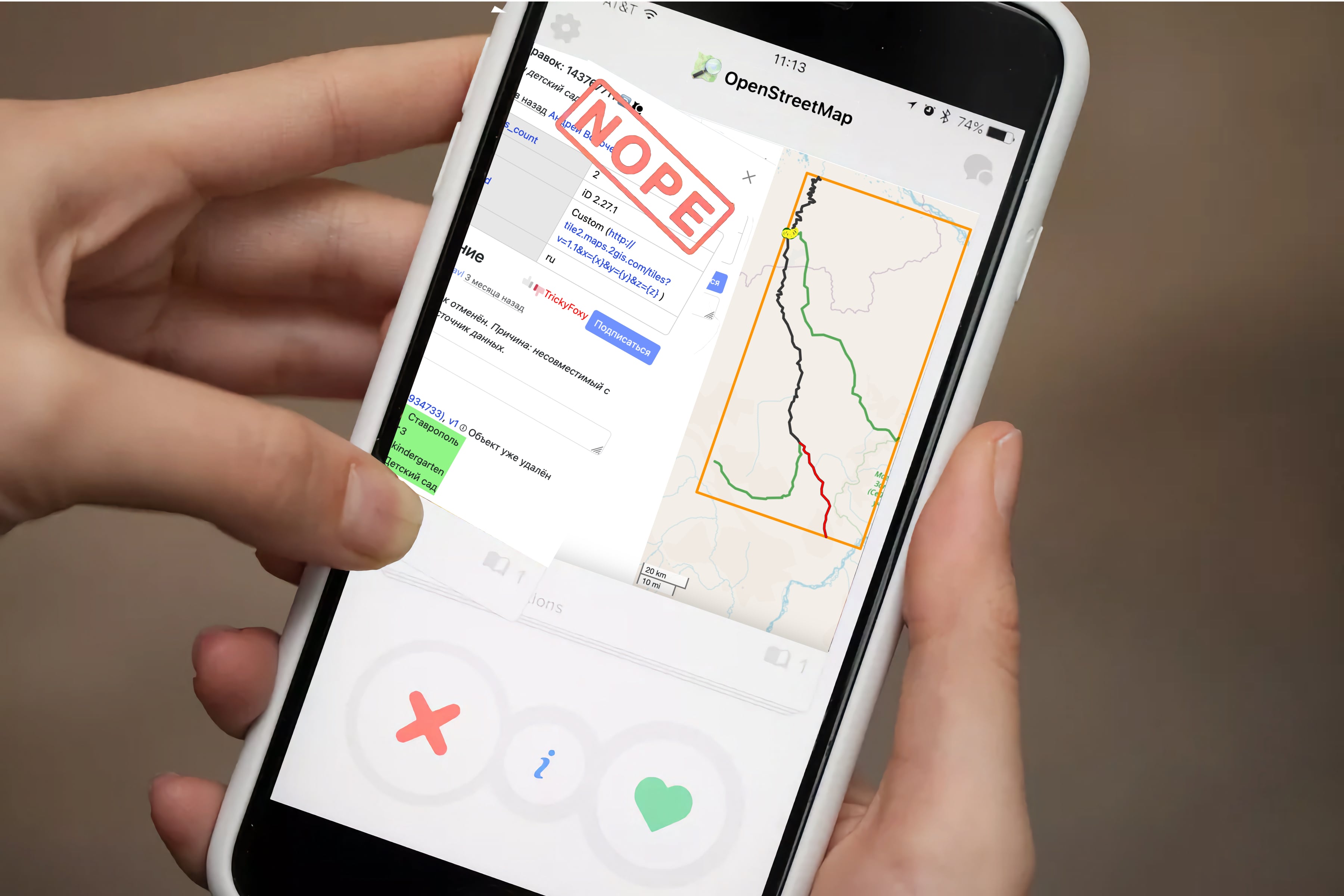
🖼 Visualization of changesets
Previously, you could only view changes in tags and only minor changesets. Now you can see objects that have been changed, and pagination is removed whenever possible:
Posted by UNGSC-DTLM-Ale_Zena on 26 September 2024 in English.
Working mainly in Africa it’s not rare to come across to crowdsourced powered mapped areas. I still repair, from time to time, the disaster done in 2022 in Mogadishu
Today, near Bor osm.org/#map=17/6.178444/31.578194 , another masterpiece: a lot of triangular (one 2600 sqm trapezoidal) buildings, and 3 tourism=camp_site
Who does need this rubbish? How good the validator to the related HOT task worked?
Alessandro
Posted by Joseph Munyenze on 26 September 2024 in English.

Hello fellow mappers! 👋
As an avid contributor to OpenStreetMap, I’ve found that having quick access to helpful resources can make the mapping process smoother and more enjoyable. Whether you’re mapping disaster-stricken areas 🌪️ or filling in the gaps for unmapped communities 🏞️, these resources will help you along the way.
Here are some key tools and resources that have been invaluable for me during my mapping journey:
🔑 OSM Resources for Mappers
-
OpenStreetMap Wiki
A comprehensive resource on all things OSM, including documentation, tagging guidelines, and community projects.
➡️ OSM Wiki -
LearnOSM
If you’re new to mapping, this guide is an excellent starting point. It covers the basics and also includes more advanced tutorials for improving your mapping skills.
➡️ Learn OSM -
HOT Tasking Manager
If you want to contribute to humanitarian mapping projects, the Humanitarian OpenStreetMap Team (HOT) Tasking Manager helps you find tasks related to disaster response and global development.
➡️ HOT Tasking Manager -
iD Editor
A simple web-based editor that’s perfect for beginners. You can edit maps directly in your browser without the need for external software.
➡️ iD Editor -
JOSM (Java OpenStreetMap Editor)
A more advanced desktop editor for OSM, offering powerful features for experienced mappers who want to work on larger projects.
➡️ JOSM Editor ➡️ JOSM Download -
Mapillary
This tool lets you access street-level imagery for places where map data might be missing or outdated. It integrates well with OSM for adding detail to map features.
➡️ Mapillary -
Overpass Turbo
A query tool for filtering specific OSM data, helping you search for, and visualize, map features based on tags or location.
➡️ Overpass Turbo -
OSMCha
A tool for reviewing changesets and helping to ensure map quality. It’s great for monitoring edits and improving the accuracy of mapping data.
➡️ OSMCha
🧑🤝🧑 Join the Community

I really wanted to participate in the State of the Map 2024 in Kenya to broaden my horizons, understand what is happening under other skies and exchange with members of other communities to draw from their experience: How they are organized and how they stay dynamic. My illusions found a dazzling light, from the moment the scholarship team accepted my application. I was so happy like my wedding day. 😃
The 3 days were each particularly better, the different subjects selected were breathtaking
I am happy to receive the HOT Open Summit scholarship to attend the State of the Map 2024 held in Kenya. I can give a lecture on-site. But unfortunately, I got influenza and felt very ill during my trip to Kenya. Most of the time I have to stay in bed. So sad I can’t join the meeting during the conference.
 (Photo credit: Arnalie)
I had to skip the first day of the conference in the first day due to illness. But I feel better the second day. The conference was held in the hall in Nairobi Tower, University of Nairobi, which is quite comfortable for all of us attendees. This is my third State of the Map, the second time in person.
It seems that the conference was held in Africa and quite a distance from most of the OpenStreetMap contributors. There is a much smaller size compared to other years’ State of the Map conference. It is still a very valuable experience. Face-to-face communication is still the most effective way to communicate between OpenStreetMap contributors.
Posted by arnalielsewhere on 24 September 2024 in English.
With my State of the Map Working Group - communications hat 👒 , one thing that really put a smile on my face is checking the stats of scholarships given! 😍
Quick stats re scholars from the OSMF SotM WG & Humanitarian OpenStreetMap Team #HOTOpenSummit Travel Grant Programs:
- 💻 10 online scholars
- ✈ 50 in-person scholars
- 🌍 🌎 🌏 from 27 countries
- 💛 💜 24 women : 36 men
- 1️⃣ 80% attended their first #StateoftheMap conference!
- plus 29 🎟 were given for free!
I cannot express enough how amazing it feels to see this stats. As someone who got exposed more to OpenStreetMap community after attending her first global SotM conference six years ago (my diary here), this gave me much hope and encouragement that we’re building an inclusive map and community 🗺 🤝