OpenStreetMap logo OpenStreetMap

Diary Entries in English

Recent diary entries

Posted by alan_gr on 28 October 2024 in English. Last updated on 28 July 2025.

Brands

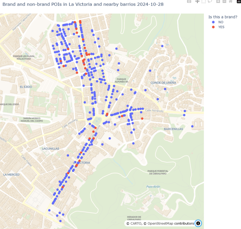
As part of my systematic update of local POIs (see Part 1), I added the “brand” and “brand:wikidata” tags wherever I could identify them. Before I started I thought I might find quite a few POIs that I had not previously recognised as brands.

Spoiler: I was wrong, yet again. It’s good to have your preconceptions challenged by actual data. I guess.

It turned out that the reason I hadn’t heard of most of the brands displayed on POIs in this area, and the reason not many POIs had the brand tag before I started mapping, was that … they aren’t brands. It’s possible there are a few shops belonging to brands so obscure or localised that I couldn’t find any reference to them online, but I don’t think I can have missed many.

Out of 376 POIs, only 36 - less than 10 percent - are now tagged as brands.

map of POIs with multiple colours distinguishing different types of POI

See full entry

Location: Cristo de la Epidemia, Centro, Málaga, Málaga-Costa del Sol, Malaga, Andalusia, Spain
Posted by alan_gr on 28 October 2024 in English. Last updated on 28 July 2025.

Recently I have been trying to systematically improve OSM data about shops, businesses, and other Points of Interest in a small area of my city. Like many OSM contributors before me, I have been torn between the desire to make my local map as complete as possible, and the realisation of just how much time is needed to do that. My observations in the following series of diary posts may not be very original, but perhaps they’ll help me to clarify my thoughts on the subject.

Background

Málaga is divided into about 200 barrios or neighborhoods, all with well-defined boundaries in OSM. I chose to focus on an area of four adjoining barrios slightly to the northeast of the historic centre. The main axis of this area, formed by Calle Victoria and Calle Cristo de la Epidemia, is about 1km long (the green dashes in the map below). These main thoroughfares, and many of the smaller streets, are lined by apartment blocks with commercial premises on the ground floor. The hillier areas to the east are more purely residential. Most shops are quite small, many are sole traders, and there are no shopping malls.

See full entry

Location: Cristo de la Epidemia, Centro, Málaga, Málaga-Costa del Sol, Malaga, Andalusia, Spain
Posted by Mason Palmatier on 28 October 2024 in English.

Dear Diary,

Now I know what your thinking, “what kind of boy has a diary”. Its NOT a diary, remember that reader. Its a INTRICATE PROGRESS LOGGING DEVICE that is mine and mine only! Yeah, i guess you could say its a kind of “Dairy of a Wimpy Kid”, heh! Well thats awkward… Nettspend Out!

Location: Barracks Row, Capitol Hill, Ward 6, Washington, District of Columbia, 20003, United States

I finished solving my personal OSMose issues (mainly level 3) and other ones in municipalities around Saint-Valery-en-Caux.

To correctly tag some services, I needed to use Pifomètre for two municipalities.

I also fixed a few issues in OSM Inspector around Saint-Valery-en-Caux and Rouen, although it is pretty difficult to understand what’s wrong sometimes.

Another OSM user rightfully told me that one edit I did on bus lanes in Rouen was wrong in terms of tags, so I managed to correct it.

You may know that the preparations for this year’s OpenStreetMap Kerala Annual Meetup have started. We had a meeting on the 20th to find a suitable venue and date and to brainstorm related matters and form a working group for the same.

OpenStreetMap Kerala Community Logo

It has now been decided to hold the annual gathering of 2024 on November 16-17 at Kerala Veterinary and Animal Sciences University, Wayanad district.

Venue and Registration - Travel Scholarship - Participatory details will be updated by the responsible volunteers in the coming days.

See full entry

Location: Pokkode Diary Colony, Pookode, Vythiri, Wayanad, Kerala, 673576, India

I decided to fix, once again, all of the issues attributed to me by OSMose. I managed to fix almost all of them for levels 1 and 2. I’ll probably fix the level 3 ones tomorrow.

Today, I also discovered the OSMose map. I already knew about the website itself, but only on its personal list form. Therefore, I decided to fix almost all the issues in my hometown, Saint-Valery-en-Caux. I briefly also fixed issues in Rouen and Barentin.

I won’t add the links of my changesets anymore, as I’m too lazy to do so (lol).

Posted by TheFighter137 on 26 October 2024 in English.

Hello everyone, I have come to the conclusion that the daily mapping challenge I started was probably too ambitious considering my daily life (mainly univ), so I have no choice but to downgrade my ambitions unfortunately. I still will make my best to contribute everyday to OSM and to make daily diary entries, however they won’t be all about mapping a random municipality.

In addition to OSM, I occasionally take pictures of the areas I visit to upload them on Mapillary.

There are a few reasons I enjoy contributing to Mapillary:

  • it constitutes an historical archive of pictures over time, seeing how a corner changed brings up memories and documents changes. I personally lived in two cities (Milan and Berlin) that changed a lot over the years and like to document it and observe these changes over time
  • in Milan it can be used to document the space used by vehicles, including the irregular one, which is a detail not present in OSM tags
  • it’s suitable for machine learning. I for one have a second job as a teacher for Data Science Retreat and a few students used this data to classify the quality of bike paths. Mapillary already automatically identifies, geolocate and segment common elements like street signs and manholes
  • it’s suitable (sometimes) for 3D reconstructions for artistic purposes, like games (example here, it’s not based on ad-hoc images but mapillary could reasonably be used for it too. Mapillary calculates and provides point clouds too). I think this is an area where new approaches like gaussian splatting can do a lot
  • it can, of course, be used for micromapping in OSM, these images show shop names, street etymology, fences and other details not easy to spot from satellite data and hard to add on the spot using StreetComplete or similar. Images from Mapillary are accessible directly in the iD editor.

For these and other reasons I contribute to Mapillary since years, using my phone with the Mapillary app whenever I visit a new or interesting place.

Imagine then my surprise when, a few months ago, I was contacted by Meta’s Reality Lab. They saw my contributions in Milan and offered me to borrow their GoPro MAX 360 which was not used anymore by another Mapillary contributor, to contribute as I see fit.

See full entry

Location: Greco, Municipio 2, Milan, Lombardy, 20125, Italy

Today (or rather, yesterday), I worked on Illois. Near this little village, there is the A29 highway and the D 929 road. There aren’t too many single-family homes, mainly because quite a few buildings are for agricultural purposes.

Link to today’s changeset

Location: Coupigny, Illois, Dieppe, Seine-Maritime, Normandy, Metropolitan France, 76390, France

Recently I’ve noticed that most of the time I spend on OSM goes either to:

  • Patrolling recent changes and fixing things which, although were already mapped correctly for years (often by myself), now have been altered (probably in good faith though!) by some newbie who „thought” that the current state is somehow wrong
  • Fixing things which were already mapped incorrectly for years (often by myself) at a time when the documentation was unclear or the community consensus was different

This is no good, as repetitive adding and fixing of the same things over and over can lead to hypervigilance, burnout etc., and as a result the will for further contribution to the project could disappear. As the time progresses, some newbies become not-so-newbies, face the new generation of newcomers and the vicious cycle continues.

Burnout can also lead to a premature transformation into a nagging grump, which I would love to avoid.

Solution: People with the know-how should instead focus more on providing the best documentation and tooling there is possible to the community. Working on removing ambiguities, providing accurate descriptions and thorough examples. Therefore everyone can learn (and later teach) the right approaches. This pro-active approach is more effective than a re-active one, since less time and work goes to waste, the knowledge is propagated more quickly and in a more lasting manner, economics of scale start to kick in and stuff.

Also at the time of writing this entry it is 1 AM CEST where I live so I guess this makes this post #showerthoughts -approved. Thank you for coming to my TED talk.

It’s time for another OpenStreetMap-NG development update! This week brings exciting new features and improvements that bring us closer to the project’s first public release.

🔖 You can read other development diaries here:
osm.org/user/NorthCrab/diary/

⭐ This project is open-source — join us today:
https://github.com/openstreetmap-ng/openstreetmap-ng

🛈 This initiative is not affiliated with the OpenStreetMap Foundation.


📹 Video Summary

I’ve recorded a short video summary showcasing recent progress directly on the development website. It serves as an enhanced version of this diary post, with chapter markers for easy navigation to specific topics.

⬇ Click below to play ⬇

Video thumbnail

or click here: https://peertube.monicz.dev/w/ttE2rLRD1TXB2qgmuH4NBH


Messages Reimagined

See full entry

Posted by Hillwalker on 25 October 2024 in English.

Parks on the Air (POTA) information tags can be added to areas. It’s an improvement over the POTA map application as it shows the entire park area rather than a point. For example, the Victoria Harbour Migratory Bird Sanctuary (CA-4248)… https://pota.app/#/park/CA-4258 vs. https://potamap.ea7klk.es/?CA-4258

tag - “communication:amateur_radio:pota” info - Park code ‘NN-XXXX’

Personal note

Sorry for the very delayed posting! 🥹

🎉 I can’t express how overwhelmingly grateful I am to everyone who made this idea a reality. ✨ Your passion in making the best map OpenStreetMap, and building inclusive communities is unstoppable. ❤️‍🔥

Let’s make the #OpenStreetMap the best and most inclusive space for all ✨🗺️

=Arnalie

————-

Key highlights: We are happy to share the accomplishments of the 2024 OSMF Membership Campaign: 1) ~ 392 sign up’s from March, most of them were through the Active Contributor Membership Program; 2) there are now members in 16 new countries!; 3) Four (4) countries made 15+ new members: Libya, Niger, Nigeria and Colombia; and 4) one of our team leads, Priscovia, became part of the Membership Working Group (MWG).

In our effort to grow and diversify OSMF memberships, early this year, we ran a 3-month long OSMF Membership Campaign with volunteers from all over the world.

I thought that the new year is the best time to encourage contributors to become OSMF members by spreading awareness about OSMF membership and the Active Contributor Program. The OSMF Membership Campaign Drive idea came up when a community member from OSM Africa asked about the membership make up.

See full entry

Well it has been a while. As the result, I’m 3 cities late. Fortunately, one week of holidays is coming, so I will have quite a lot of time to catch up.

Today, I worked on Harcanville. It is a small village near Doudeville, a bigger city. It is mainly made of single-family homes, but there are quite a few agricultural buildings also.

Link to today’s changeset

Location: Quievremont, Harcanville, Rouen, Seine-Maritime, Normandy, Metropolitan France, 76560, France
Posted by evdence on 23 October 2024 in English.

A few days ago, I started my mapping project for Jāņupe. The main objectives of this project are to add all the missing houses in the area, re-tag the existing ways and some nodes, and retrace the residential and allotment zones.

Current goals:

Add houses:

I will add all missing (unadded) houses in Jāņupe and neighboring settlements to make the map look more beautiful and updated. The current state of the map in that area is really not good, in some places, the map hasn’t been updated for 5+ years.

Re-tagging:

I will re-tag most places and roads in this area, as well, I’m going to be adding highway = turning_circle in places where they haven’t been added, and changing residential road tags to living street tags.

Retracing areas:

I will trace and re-trace most allotment and residential areas in the area, since most are wrongly drawn.

Upcoming challenges:

While I’m looking forward to work ahead, I will face some challenges like outdated data (for example some cadaster buildings are wrongly drawn or are outdated), or not much available resources to use.

I aim to finish this project in the next 2-3 weeks, breaking the project down into manageable parts. :)

Location: Zustari, Jāņupe, Olaines pagasts, Olaine parish, LV-2127, Latvia

I’m still late : I was supposed to do a municipality with the letter H today. I probably won’t do the letter I tomorrow either, nor Wednesday, however I’m pretty sure I will be able to on thursday.

Today, I worked on Gaillefontaine. For a rural city it is actually pretty diverse in terms of construction : the center has historic buildings, but it is mainly surrounded by single-family homes. The northwest has an industrial area though, and it looks like there are monuments on the southeast.

Links to today’s changesets :

  1. First
  2. Second
Location: La Bataille, Gaillefontaine, Dieppe, Seine-Maritime, Normandy, Metropolitan France, 76870, France
Posted by Calvin Menttor on 21 October 2024 in English.

Volunteerism, commitment, and dedication are our hallmarks as YouthMappers!

Now, repeat after me: YouthMappers Ghana… Right! We volunteered to contribute to developing a sustainable, eco-friendly urban environment in Koforidua collaboratively, and collectively (SDG 11). Using OpenStreetMap to put streets and landmarks in the right places—because let’s be honest, we’ve all been “LOST” thanks to outdated maps nau…! 😅 This is what we do while building technical skills. 🖐🏾High five to all contributors, validators, Bullet OSM and OSM Ghana.

See full entry

Location: Koforidua Ada, Koforidua, New Juaben South Municipal District, Eastern Region, Ghana

Today, I worked on Fallencourt. This village is smaller than the previous ones I worked on for my challenge, however something big is nearby, the A28 highway (I’d guess it creates quite a lot of noise). There is a bus stop in the center, however it isn’t used as far as I know, apart maybe by school buses.

Link to today’s changeset

Location: Fallencourt, Dieppe, Seine-Maritime, Normandy, Metropolitan France, 76340, France