OpenStreetMap logo OpenStreetMap

Diary Entries in English

Recent diary entries

In collaboration with a local team in Grünstadt, Mannheimer Mapathons e.V. completed the mapping of the historic Jewish cemetery in early 2024 after five months of data collection. The cemetery was used by the important Jewish community from around 1700 to around 1937 and comprises 464 gravestones that are still visible. A high-precision Sparkfun RTK Facet GPS receiver was used for the survey. A map has been available online since May 2024. In recent weeks, with the support of the Heidelberg University of Jewish Studies, the names and dates of many of the oldest purely Hebrew gravestones have been catalogued and integrated into the map data. The translation work will continue with the aim of supporting both descendants and historical research.

In Zusammenarbeit mit einem lokalen Team in Grünstadt hat Mannheimer Mapathons e.V. nach fünf Monaten Datenerhebung Anfang 2024 die Kartierung des historischen jüdischen Friedhofs abgeschlossen, berichtet RCD49. Der Friedhof wurde von der bedeutenden jüdischen Gemeinde etwa von 1700 bis ca. 1937 genutzt und umfasst 464 noch sichtbare Grabsteine. Für die Erfassung kam ein hochpräziser Sparkfun RTK Facet GPS-Empfänger zum Einsatz. Seit Mai 2024 ist eine Karte online verfügbar. In den letzten Wochen wurde mit Unterstützung von der Hochschule für Jüdische Studien in Heidelberg begonnen, Namen und Daten von vielen der ältesten rein hebräischen Grabsteine zu erschließen und in die Kartendaten zu integrieren. Die Übersetzungsarbeit wird fortgesetzt, mit dem Ziel, sowohl Nachkommen als auch historische Forschungen zu unterstützen.

Location: In der Bitz, Grünstadt, Landkreis Bad Dürkheim, Rhineland-Palatinate, 67269, Germany
Posted by WilliamHarrison on 9 August 2025 in English.

Hello!
I’ve been mapping in OpenStreetMap for a few years now, and I believe the current method of mapping routes is quite painful and wastes hours of editors’ times to just upkeep it, So, here is my idea on how we could fix it.


The Idea

In essence, it is to have just one start node and one end node, the router (using the bus profile) then calculates the route deterministically, with additional points in between added only as needed to achieve the desired path.

For example, in the case above, the route can be simplified from 123 ways down to just 5 nodes representing the path. (In reality there would be nodes at every station, so it wouldn’t be as few as 5)

This approach is;

  • Resilient to edits,

  • So many times easier to maintain.

Demonstration image showing 5 nodes representing a bus route. I’ve compiled Valhalla on Linux and created a quick proof of concept program showing this can already be implemented (unofficially) in custom code.

See full entry

Posted by Rivai Sigit on 9 August 2025 in English.

Riau: Empat Sungai Raksasa

Pembukaan

Dua hingga tiga abad sebelum kita mengenal provinsi yang bernamakan Riau, dahulu para pelaut mengetahui daerah ini sesuai dengan nama sungai besar yang ada. Sungai Rokan, Siak, Kampar, dan Indragiri, terkenal dengan sumber daya yang mereka bawa ke berbagai pusat perdagangan di Selat Melaka. Kedatangan Portugis ke Melaka dianggap sebagai titik mula nama ‘Riau’ terdengar, karena kata ‘Sungai’ dalam bahasa Portugis adalah ‘Rio’. Mungkin penjajah Portugis pada zaman itu tidak bisa mengucapkan nama-nama sungai tersebut dengan baik, dan perubahan simpel dengan merujuk mereka sebagai ‘orang-orang sungai’ lebih mudah bagi mereka untuk diingat.

Tiap sungai ini mempunyai sejarah & ciri khas-nya tersendiri, dan diary ini akan mencoba untuk menjelaskan secara singkat tentang keberadaan empat sungai besar yang ada di Riau.

Rokan: Sungai Kejayaan

Sungai Rokan

See full entry

Posted by Brazil Singh on 8 August 2025 in English. Last updated on 9 August 2025.

Brazil Singh My OSM Wiki

About Me

I am Brazil Singh, an open mapping advocate, digital innovator, web developer, and community leader from Bangladesh. As an Open Mapping Guru at the Open Mapping Hub Asia-Pacific, I equip communities with practical and impactful mapping skills. I play a key role in managing social media for the OSMF, and actively contribute as a volunteer in the OSMF Local Chapters and Communities Working Group (LCCWG). Additionally, I am a committed member of the Humanitarian OpenStreetMap Team’s (HOT) Community Working Group and a Volunteer Regional Ambassador of YouthMappers.

See full entry

BOOK RELEASE IN THE III WORKSHOP ON PARTICIPATORY MAPPING AND SOCIAL CARTOGRAPHY - MPCS 2025


Ler em português

The book “Case studies in collaborative and participatory mapping” (original Estudos de caso em mapeamentos colaborativo e participativo) is a collective work, organized by Dr. Raquel Dezidério Souto, which includes 20 chapters with reports on research that adopted collective mapping methodologies - collaborative or participatory and social cartography, in the five regions of Brazil and for a wide variety of purposes, from nature conservation to the recognition of traditional communities, the inventory of urban infrastructure, and the enhancement of historical and cultural heritage. We hope that its publication will shed light on the importance and applicability of these methodologies and contribute to expanding the network of knowledge around this theme.

The book release date has been set: August 29, 2025, at 4 p.m. (UTC-3), with live streaming on the IVIDES YouTube channel

The complete schedule of the Workshop MPCS 2025 is now available here.

See you in August at this 100% online event, which is completely open to the public. The registration is available on the official website

See full entry

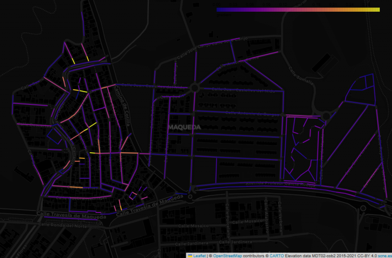
Map of the Maqueda barrio in Malaga, showing streets colour-coded by estimated gradient, on a dark background

This image shows the Maqueda barrio in Malaga, with streets colour-coded by estimated gradient. The flat area to the east shows up with cold colours, while the western part of the barrio, which straddles a ridge, generally has warmer colours. But why did I make this map, and what does it have to do with “streets that are really steps”?

In my wanderings around the city of Malaga, I have often come across flights of steps that are not tagged as highway=steps in OpenStreetMap. Usually they are tagged as residential or footway, with misleading results for anyone using OSM-based maps or routers to find their way around the city.

See full entry

Location: Maqueda, Santa Rosalía-Maqueda, Campanillas, Málaga, Málaga-Costa del Sol, Malaga, Andalusia, 29591, Spain
Posted by shetto on 7 August 2025 in English.

I started mapping on 7 of August using StreetComplete. I discovered (unfortunately) that I understood some criteria concerning road smoothness wrong, and I was no longer sure if my edits from the first day were correct, so I decided to delete most of them, to remap and do it properly. Furthermore, I apologize if anyone had any inconvenience of my poor first mapping steps.

I will stick to mapping and hope to improve in the future. :)