OpenStreetMap logo OpenStreetMap

Diary Entries in English

Recent diary entries

Posted by mvexel on 14 February 2023 in English.

I’ve been closely involved with the journey Rapid is on. The first version of Rapid was released in 2019 as the first OSM editor that added machine learning-derived layers you could easily add to OSM in one click: roads from Meta and building footprints from Microsoft. This groundbreaking work enabled efficient, but human powered adding of vetted external data to OSM, and continues to be one of the most widely used methods for doing so. Since the original launch, a collaboration with Esri’s community data program added many additional layers of authoritive data available to add to OSM in the same way.

As government agencies continue to make more data available to OSM through Rapid (around 145 as of now, with hundreds of millions of features), work on version 2 started in early 2022. Developers Ben Clark and Bryan Housel presented the early stages at State of the Map US in Tucson last March, and followed up with a more technical talk about the underlying technology changes at FOSS4G in Firenze. Alpha versions of version 2 have been circulating since then. I have been using these extensively, especially in the past two months. I’ve been barraging Ben and Bryan with bugs and feature requests, as have many others who have participated in the alpha testing phase. A ton of issues have been resolved since the first alpha release, and we’re very happy with where we are with Rapid 2.0. Happy enough to launch version 2 beta today! 🎉

What’s new in Rapid 2.0

If you haven’t used Rapid at all yet, this is a great opportunity to try it for the first time. Many things will feel familiar if you’ve used the built-in editor on openstreetmap.org, but you will also notice small conveniences you won’t find there—or anywhere—like a shortcut to quickly cycle through highway types when you have a way selected, “virtual nodes” that are displayed for polygons with POI tags and improved polygon labeling:

See full entry

Location: 9th & 9th, Salt Lake City, Salt Lake County, Utah, 84102, United States
Posted by Karst Detective on 13 February 2023 in English.

I’d used the OSM editor for work some time ago, and decided to practice a bit- using my own stomping grounds as the subject material.

I don’t know if any Locals are trying to keep up with the Town’s alterations, but I still haven’t fixed ‘Costumes, Balloons, and Stuff;’ It’s still on the map despite having closed Six and a Half Years Ago. I’ll get it next time. ((Not that I want to. I really miss that place.))

I fixed a few of the nagging sidewalk issues, and some of the more popular buildings and businesses. Remove the demolished bridge, that sort of thing.

That’s it. I just wanted OSM to reflect the local reality.

Posted by Jacob Helfman on 12 February 2023 in English. Last updated on 18 February 2023.

Separating features

  • To split a line, select the node, then click on Tools >Split Way (P shortcut). Unglue the node using the shortcut G.

  • Buildings tool or Mapathoner plugin: To merge overlapping buildings, join them using shortcut Shift+J (same shortcut for joining node to way).

  • To create a circular building, create a line (A), then while it is selected, use Shift+O.

Location: Castle Park, Chula Vista, San Diego County, California, 91911, United States

First, I want to thank God, the almighty for His blessings and grace always. It’s indeed an honor to represent my beloved country, Sierra Leone and my unique university, Central University SL at the 2023 YouthMappers Leadership Fellowship Summit in Jamaica(Jan 5-12,2023)

Being certified as 2023 YouthMappers Leadership Fellow is something that has inspired me more. The 2023 YouthMappers summit helped me explore in different important areas. I was opportuned to learn about leadership, equity and inclusion and climate change and resilience and geospatial mapping tools and softwares.

Special thanks to YouthMappers,the organizers and our sponsors USAID, Texas Tech University, Arizona University, George Washington University and West Virginia University. We are grateful for the support and knowledge impacted.

Special thanks also to the Openstreet Map Team,Sierra Leone and the YouthMappers Regional Ambassador Sierra Leone for the guidance and mentoring.

A big thank you to Central University Management and my hardworking team, Central University YouthMappers. I am proud to be a Centralist. Thanks to my family and friends for the support. I am blessed to have you all. I am always grateful to you all.

YouthMappers

#ymsummit2023 #Openstreetmap #EverywhereSheMap #centraluniversityyouthmappers

Location: Kamasundo, Port Loko District, North West Province, Sierra Leone, Sierra Leone

SotM Baltics 2023 logo

It’s that time again: we are ready to announce the third Baltics-located conference on OpenStreetMap and everything around it! Just like three years ago, we are joining the BalticGIT org team to have an opportunity to gather everyone interested in open data and open tools to present their work, meet other mappers and developers, and spend two days in a beautiful city on a super wide river.

Mark the date: 18-19 May (that’s Thursday and Friday!) in Riga, Latvia.

See the website for details.

The RIX airport is a home base to AirBaltic which has flights from like a hundred locations around the world. It’s really easy and affordable to come. So, we would be delighted to meet you there!

We are opening the call for papers. Please submit your topics, and we (me, that is) will contact you. We understand it’s just three months, but again, this is an OSM event, where there are new things every month :)

Registration will open a bit later, which we will also announce.

Posted by Neky18 on 11 February 2023 in English.

Today being the 11th day of February, 2023, I took the decision to join the OSM training after some persuasion from my friends who have been a part of this community. The training this morning opened my eyes to quiet a lot of things as it concerns the global mapping community. Before the commencement of the training, I received a T-shirt and a bag, which made me feel I was already a part of Unique Mappers Network.

I didn’t know what to expect but I can confidently say now that I am glad I took the decision to attend. In the course of the training, it came as a surprise that I was actually interested in what was being done as I started to find it educative and interesting. There were some initial difficulties I experienced especially in learning how to map a community but I didn’t let it deter me.

I gained the knowledge of what Open Street Mapping is all about, being that it deals with the local and global community at large. I learned that Open Street Map is a global map of the world that is open to the people as it is a humanitarian service geared towards helping people in need.

This evening, I joined the zoom meeting of which I gained better clarity on how to map on HOTOSM. We were encouraged towards mapping the disaster struck Turkey as a way to enable search and rescue teams have better access to buildings that may have been struck in the course of the Earthquake.

At the moment, I’ve mapped over a hundred buildings and roads In Turkey and would continue to do so with the knowledge that this is my contribution to community development and a humanitarian service to the world.

UMTMapTurkey

#uniquemappersteam #uniquemappersnetwork #uniquemappersnetwork2023

Posted by charles chilufya on 11 February 2023 in English.
              #STATE OF THE MAP TANZANIA

STATE OF THE MAP TANZANIA

State of the Map Tanzania is a national conference that celebrates the culture of open mapping, open data, GIS, and its impact across East Africa. The conference took place on 20th-22rd January 2023 in Dare salaam, Tanzania. The conference had the following goals

-Learn from one another to improve OpenStreetMap and Open Data in Tanzania.

-Promote cartographic innovations in Tanzania.

-Place OpenStreetMap as a governance and sustainable development tool.

-Bring together all OpenStreetMap Tanzania Communities to share their experiences and achievements. For more info about the conference visit https://stateofthemaptanzania.org/

activities Joined

  • I participated in the Mapbox and how to utilize it for free. it was my first time understanding that Mapbox can be used for free by the communities. I learned that MapBox allows individual subscriptions and enjoy their services.
Posted by mariotomo on 11 February 2023 in English. Last updated on 13 February 2023.

curious experience, being locked out because of etiquette misbehaviour.

account suspended

I heard about the procedure against me only after the procedure had been closed with a condemnation, 4 votes approving, 1 abstaining. not only no space to present my point of view with the people who were to decide, even no notice of the pending procedure. speak about openness.

what were —concretely— my abuses? I may guess, but I was not —concretely— notified of what was the violation. maybe the same as my previous block. I had to review my own behaviour myself, perform a radical self-criticism, purge myself of all evil, then came back once purified.

I’m happy I renounced my membership of such a Foundation.


a clarification apparently needed, seeing the first two comments to this entry: I obviously do know that I have a continuous latent conflict with YouthMappers and HOT. I did not know that steps were being taken against me. then I received the following email:

See full entry

Posted by Heather Leson on 11 February 2023 in English. Last updated on 16 February 2023.

Editor note: Written by Heather Leson, Dinar Adiatma, and Can Unen

Having the most up-to-date and accurate map data is crucial for emergency response. The OpenStreetMap community and partners create this to support humanitarians. The OSM data is shared on the Humanitarian Data Exchange and is used to develop information management (IM) products for decision-makers responding to emergencies.

This short note is to help new mappers get started and to encourage data quality. The local Turkish community, Yer Çizenler, and HOTOSM coordinate this activation. For Syria, mapping is more complex as it is a conflict zone. HOT is working closely with OSM colleagues and partners to assess any HOT tasks in Syria carefully. As it is a conflict zone, we will collaborate to ensure that HOTOSM Task Manager OSM contributions cause no harm. We are here to help the helpers. We know that many want to help. We ask that you talk with other mappers to learn and help the responders while respecting the local guidance.

Data quality is important in OpenStreetMap (OSM) because it directly affects the accuracy and usefulness of the map. All data should be fit for purpose, and to make it fit purpose, it requires a minimum gap. Poor data quality can lead to incorrect or outdated information, negatively impacting the people relying on OSM for navigation, planning, and decision-making. Learn more here.

Contacts - The HOT Activation Coordinator contacts can be found on the OSM wiki

New Mappers

Are you new to OSM? This is a complex emergency, and we are glad to help you get started:

  1. See basic videos on how to map via MapGive
  2. Review Learn OSM and see the OSM wiki guidance for this emergency
  3. Observe the daily live stream and join a mapathon
  4. Use the MapRoulette challenges of Yer Çizenlerto tag the collapsed buildings from verified datasets.
  5. Join the HOTOSM slack channels for #disastermapping and #mappersupport
  6. Ask for help - the community is here to support your OSM journey

See full entry

Location: Cité, Geneva, 1204, Switzerland
Posted by pedrito1414 on 9 February 2023 in English. Last updated on 10 February 2023.

I received this question through the HOT feedback form today. Here is my response in case anyone else wants to know.

Re: Is what I am doing really helping anybody in a disaster situation?

The short answer is yes, we think so - the tasking manager projects have been created based on requests from organisations who plan to use the data.

The long answer is that in the immediate aftermath, everyone is looking for resources, including data, but we get very little feedback initially as to who exactly is using it.

People and orgs are busy responding. This info usually surfaces a little later and we will update when it does. In previous disasters such as the Haiti earthquake in 2010, Philippines typhoon Yolanda in 2013, and Ebola outbreaks in West and Central Africa, we have observed that responding agencies often begin using the map data a few weeks into the response, after the initial rush to establish the basics is done. This is only possible if we start early, so that by the time responders need it the data actually exists.

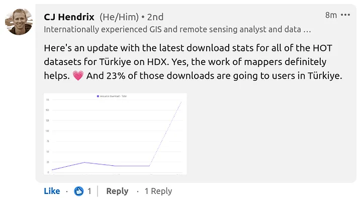
One proxy we do have is that the downloads of OSM datasets provided by HOT through the HDX platform are spiking. There is a lag on the reporting (so latest numbers are from 06 Feb) but we do see them going up. HDX is a key data source for humanitarian responders.

See full entry

Posted by pedrito1414 on 9 February 2023 in English. Last updated on 10 February 2023.

Ruben Martin and I discuss the recent activities and what’s coming up for the humanitarian open mapping community.

What’s covered this week in brief?

Earthquake response in Turkey and Syria // The first OSM diary from State of the Map Tanzania // Thank you packs received by top performing validators // An interview with OSM Somalia // Advances in the OSM contribution decline analysis and research // OSM Malawi @ community working group // Mappy quote of the week

This week we were excited by…

Earthquake Response

This is not ‘exciting’, but very significant… The open mapping / OpenStreetMap community have responded in numbers to support people affected by the earthquakes in Turkey and Syria.. Just yesterday, over 1200 people contributed to mapping tasks in Turkey. New projects have also been published for Syria. The response in Turkey is being coordinated locally by mapping NGO, Yer Çizenler, who are working to connect local partners with the data.

Infographic of earthquake impact and mapping projects

OSM Diary — SotM Tanzania

See full entry

Posted by Letwin on 9 February 2023 in English.

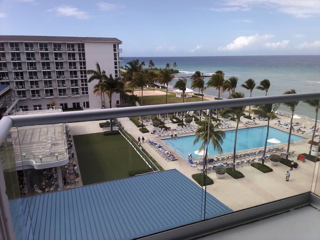
montegobay Of course we woke up to this every single morning!

This year started on a high note for all YouthMappers selected for the 2023YouthMappers Leadership Fellows Summit in Montego Bay, Jamaica.

YouthMappers from different parts of the globe embarked on a very exciting trip to Jamaica, I was one of them representing my mother country Zimbabwe. I bordered from Lagos, Nigeria and calculating the hours and days to get to Montego Bay kept me in suspense and some kind of curiosity. I travelled with YouthMappers from various states of Nigeria, it made the trip much exciting and fun. The joy of meeting someone new, someone who’s passionate about the same things you are also into, exchanging those big smiles and hugs made it worthwhile. So I’d say my summit experience commenced the instant I met my first Summit mates and trip mates!

See full entry

Posted by jfd553 on 8 February 2023 in English.

Cartography in OSM is twofold: drawing and tagging. While the former only require the ability to click with a mouse for drawing a line on a screen, tagging a feature is more demanding. There are only two options for finding appropriate tags to describe a feature.

The first is to browse the wiki and find the feature’s page. Once there, you often need to dig through many other pages to find the accepted keys/values that would describe the detailed characteristics of the feature. All of this is very laborious, even for a seasoned contributor, particularly when mapping a feature for the first time.

The second option is to use search tools to find the tags you are looking for (keys or values). You can use a search engine (e.g., Google) by adding “OpenStreetMap Wiki” with your keywords to narrow down the results. You can also use OSM tools, such as TagInfo, TagFinder, OSMantic JOSM Plugin and some others. These tools work well if your keywords match existing keys or values, but it gets trickier if they don’t. However, for a few months now, a new tag search alternative has been offered: ChatGPT.

ChatGPT (Chat Generative Pre-trained Transformer) is a chatbot launched by OpenAI in November 2022 [1]. OpenAI is an artificial intelligence (AI) research and deployment company that gives a free access to its chatbot for the time of the “research preview” [2]. Basically, once registered, a user can ask any type of questions to the chatbot. I then decided to test the chatbot on its ability to find appropriate tags for OpenStreetMap features.

Since I’m currently working in tagging businesses, I tried a few ones. Here are a sequence of questions/answers tried on ChatGPT.

Q: What would be the tag use in OpenStreetMap for a restaurant serving pizza?

A: In OpenStreetMap, the tag for a restaurant serving pizza would be “amenity=restaurant” and “cuisine=pizza”.

The answer is good, but restaurants and pizza could easily be linked together. So, I decided to make it more difficult…

See full entry

Location: Rock Forest–Saint-Élie–Deauville, Brompton–Rock Forest–Saint-Élie–Deauville, Sherbrooke, Estrie, Quebec, Canada
Posted by ImmaBeReborn on 8 February 2023 in English.

Fuck politicians and those responsible for current internet situation, since when in tarnation I need to use VPN for accessing OSM and it’s relevant services?? Seriously? That much of disruption in internet that tools like josm don’t work?? Internet already sucks enough, I have to use a damn VPN for using OSM Imma gonna fade into horizon!