OpenStreetMap logo OpenStreetMap

Diary Entries in English

Recent diary entries

Posted by Yivan000 on 5 March 2023 in English. Last updated on 1 September 2023.

There are numerous standards and tagging practices being used to map subdivisions in the Philippines. Here I listed some of the current practices, and my own standard that aims to be more fitting for subdivisions.

Note that I am referring to gated subdivision communities (that have the block lot scheme) and not barangays that happen to be named with a “subdivision”.

Current practices

Below are some that I have seen and the problems with it.

See full entry

Back in July 2022, I started mapping schools in Chandigarh. Now that I’m thinking, it wasn’t mapping schools (Oberaffe had already marked areas and added amenity=school tags a decade earlier) but adding names and a bunch of other information tags to those. It was a fun little activity which lead, in my estimate, touching of all schools (and a bunch of colleges as well), which numbered ~200 in Chandigarh and periphery. Areas where I had issues adding data have been populated with fixme tags for in area mappers to help out. Most of the data has flowed to downstream applications like OSMand and Organic maps, which look nice and full now, just like all the yellow areas on standard map.

On to the next adventure, to mark schools (and colleges) in Panchkula; Chandigarh’s next door neighbor.

So, I went to visit a friend in Westport, Ireland for a few days, stopping in Dublin on the way. I tracked all the bus routes and painstakingly added them to OSM during my stay and when I got home. There were five bus routes in total:

  • bus 760 from Dublin Airport to Galway
  • bus 456 from Galway to Westport
  • bus 450 from Westport to Murrisk and back
  • bus 450 from Westport to Dooagh on Achill Island and back
  • bus 440 from Westport to Athlone
  • bus 73 from Athlone to Kilkenny

See full entry

Location: Cahernamart, Westport Urban Electoral Division, Westport-Belmullet Municipal District, County Mayo, Connacht, Ireland

This is a cross-post from my blog.

This post is a follow-up on my series on GoPro Max panoramic imagery capture for Mapillary. Find part 1 here and part 2 here.

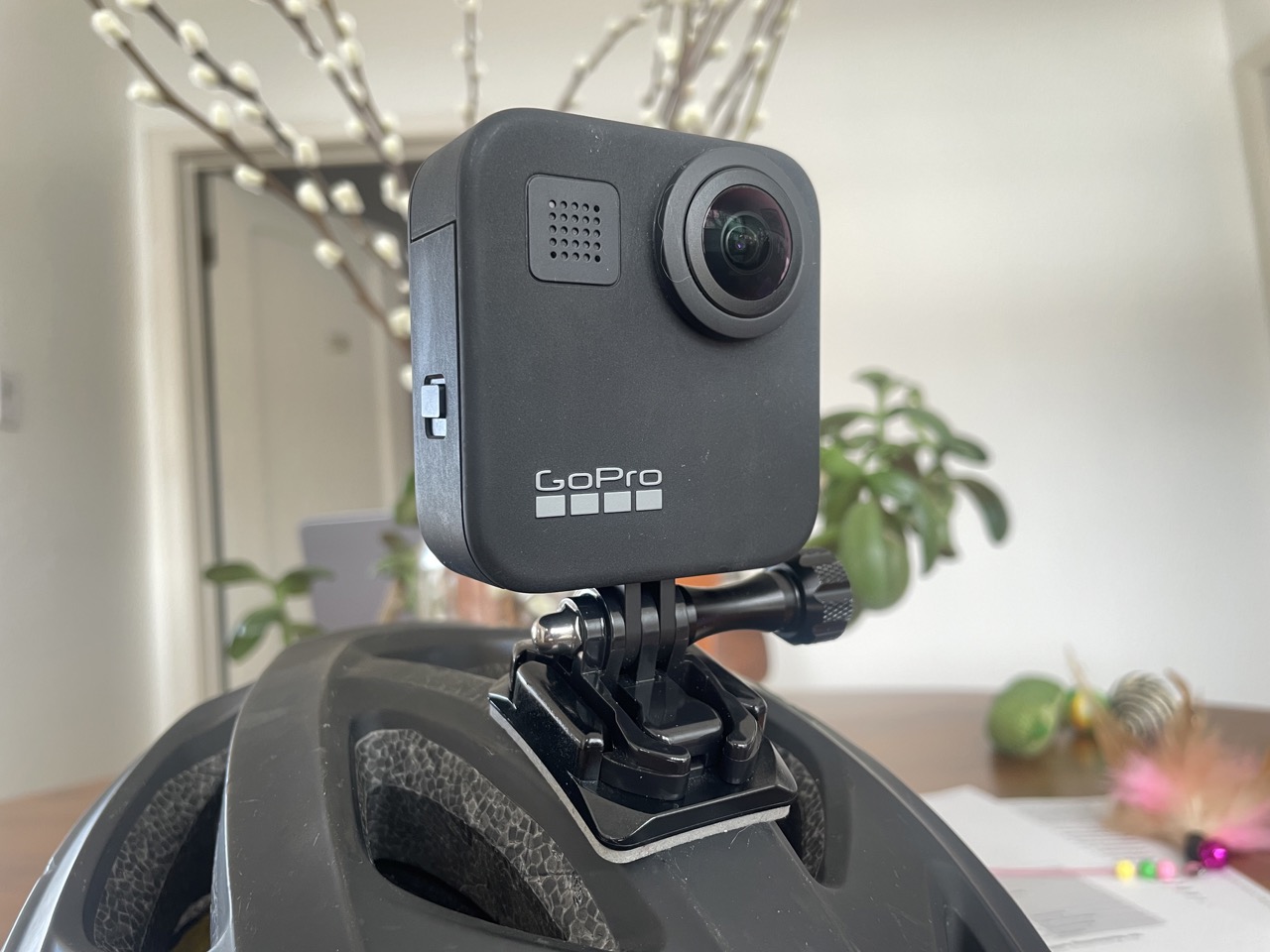
To capture true 360 degree images with a camera that has just two lenses, compromises are unavoidable. Optics dictate that a lens that captures a 180 degree field of view will have some image sharpness falloff at the edges of the field of view. I hadn’t considered this when I first started capturing with the GoPro MAX. I just mounted it the way I would a regular GoPro and didn’t give it another thought:

cam on helmet, pointing forward

Until I started looking at the result more closely. Here’s a detail of a recent capture:

See full entry

Location: East Central, Salt Lake City, Salt Lake County, Utah, 84102, United States
Posted by Peter Elderson on 3 March 2023 in English. Last updated on 4 March 2023.

This diary entry contains a wrap-up of discussions on the osm forum, (dutch section and general section). I’ve tried to capture all that has been said into a logical narrative and solution proposal.

Improved mapping of embankments

Objective

Establish improved mapping of embankments. This includes small embankments and large embankments; one-sided, two-sided and irregular embankments; embankments to contain and to protect against water, embankments to support roads and railways, and embankments serving as a traffic barrier, visual barrier or sound barrier. The aim is mainly to enable fuller rendering on maps, including at least the extent of the slopes. It is NOT the intention to establish full mapping of all aspects of embankments. However, it also should not exclude richer mapping of embankments in the future.

Starting point

Embankments can currently be mapped as:

embankment=yes on a way on the crest of the embankment.
This is especially useful if there is a road, track or path on top of the embankment. Some renderers also handle a single way tagged only with embankment=yes, without a main tag. The tag can modify the rendering of the way, to suggest it is supported by an embankment. Comparable to how a way can be altered by the tag bridge=yes. Other non-approved values are sometimes used, e.g. embankment=dyke for a way on a dyke/dike/levee. There is no established way to indicate further details of the embankment itself, e.g. left/right differences, landcover or surface, steepness, width. Theoretically one could add details like embankment=right and embankment:right:width=5 but this currently is not done. We don’t propose or oppose that.

See full entry

Posted by watmildon on 2 March 2023 in English. Last updated on 29 May 2023.

Some background

If you’re new to this wonderful dataset I encourage you to read the OSM GNIS wiki entry or play around with the public GNIS web portal. Try feature ID 1629903!

The most important bits from a summary record are the feature Name, Class, and Coordinates.

Last fall, a group of mappers coordinated to address the name updates for Department of Interior Secretarial Order 3404. We cobbled together a collection of data scrapers and spreadsheets and declared victory a few weeks later. Since then, Kai and I have been thinking “there has to be a better way”.

What can the matcher do?

For any entry in the GNIS National File we can ask the matcher to search OSM. It does this using a private Overpass instance and a set of heuristics about likely tag combination and feature types. With reasonably high fidelity we can:

  • Find GNIS entries that are very likely not yet added to OSM
  • Find OSM objects that look incomplete or incorrect
    • Missing GNIS tag
    • Missing/different name from GNIS
    • Have a geographic bounds that does not agree with GNIS
  • Generate MapRoulette challenges for subsets of the full GNIS dataset

What does it look like in practice?

We’ve generated a handful of MapRoulette challenges to check the functionality and see how it improves mapping. Here’s some examples that show off different feature types:

Sq___ Rename Validation - Final cleanup of rivers and other natural features listed in Department of Interior Secretarial Order 3404. It’s very good at noticing if a named waterway is mapped up the wrong tributary.

King County WA Place Update and San Diego County CA Place Update - Urban neighborhood names for the most part. This kind of task really does require local knowledge as the geo information for this class isn’t super precise.

Add and update Mobile Home Parks in AZ - Also from the “place” feature class but for an under-mapped feature type in OSM. This one ties nicely into a project run by MapSwipe and YouthMappers.

See full entry

Posted by juminet on 2 March 2023 in English.

Note: il y a une version française ici

From 2019, the cartographic style OpenArdenneMap is updated every 6 months. OpenArdenneMap is a cartographic style for topographic maps based on OSM data. Here are some notes for the last version.

OpenArdenneMap goes on QGIS

OpenArdenneMap was originally developed as a cartographic style with the imposm importer and a cartoCSS style derived from OSMBright. Later the osm2pgsqlimporter was used instead of the imposm. From 2023, the OpenArdenneMap is also available in QGIS, using the same osm2pgsqlimporter for building the map layers.

The tools used for making maps have some influence on the cartographic style itself. The aim of this QGIS support is to reproduce the same feeling than the maps produced with the Mapnik/cartoCSS style, even though the 2 solutions are not 100% equivalent.

Although it still requires a postGIS database, the QGIS style is much simpler to use for composing maps at various scales than the Mapnik/cartoCSS one. It was also much simpler to set up.

Here’s an extract with Mapnik

See full entry

Location: Marbehan, Rulles, Habay, Virton, Luxembourg, Wallonia, 6724, Belgium

The participation of women in activities has fairly increased over years but there are still some gaps that need to be filled and you find that women are missing or are not represented as much as they should. Then the question comes into being that what is preventing these women from participating even though there are opportunities available to them. Is it that they are just not interested or there are unseen / unheard stories that block them from participating?

In view of that I am conducting a survey on Women Participation in OpenStreetMap: Perspectives of all Genders and I will need your help in answering some survey questions.

The summary of the concept is it aims to examine the participation of women in OpenStreetMap from the perspectives of all genders, to identify the gaps that exist, and to determine how best to encourage those who identify as women to participate in OpenStreetMap. Hence a survey to source for the opinions of people. Happy to help answer these survey questions which will take less than 10mins of time :), kindly click the link here

The data gathered will be analyzed and a report will be written to inform the development of programs geared towards the participation of women in OpenStreetMap

However, a few studies have been conducted to analyze the gender distribution of OSM contributors, and the results suggest that women are underrepresented in the OSM community. Read more about the concept here

Thank you :)

Posted by Pieter Vander Vennet on 1 March 2023 in English. Last updated on 9 May 2024.

About a year ago, we launched a mapping campaign at the request from Visit Flanders (Toerisme Vlaanderen). This mapping campaign is focussed on some touristical POI, such as charging stations for ebikes, benches, picnic tables, public toilets and playgrounds. FOr this, a custom mapcomplete theme was created. (For a full explanation, see the last paragraph)

A part of the campaign involved a guided import. The agency had many datasets lying around (e.g. about benches or picnic tables) which they wanted to have imported in OSM. As doing a data import is hard and the data was sometimes outdated, we opted for a crowdsourced approach: for every possible feature, a map note was created containing a friendly explanation, information links, the tags to create and instructions to open MapComplete. When opened in mapcomplete, the user would be prompted to import the point or to mark it as not found or duplicate. All of these actions close the note with a small message on what the chosen action was.

Most map notes are closed by now, but the central question in this analysis today is: should remaining map notes be closed in batch, or do we leave them open for longer? Note that input of the local community will be gathered as well - this article will mostly serve as a point to start the discussion.

The datasets

Various datasets were provided to upload - which were converted into notes. In the table below, you’ll find a breakdown by topic, the date when they were uploaded, the number of notes created and how much of those notes were already closed and the top contributors for the category.

In this table, I’m not including if the feature has been added to OpenStreetMap, has been marked as not existing anymore or marked as being a duplicate.

Most of those notes have been opened by a dedicated account, except for two imports which accidentally did not use this account (noted in the table below).

See full entry

Today, I spent the day working on my Open Street Mapping project. Specifically, I was focused on using Leaflet mapping for sports team transport management. This project is very important to me, as I believe that it will make a huge difference in the way that sports teams are able to travel to their various events.

First, I spent some time exploring the different features of Open Street Mapping, and learning how to use Leaflet to create interactive maps. I was amazed at how much data is available on Open Street Mapping - everything from street names to building outlines to points of interest.

Next, I began to work on my project in earnest. I started by creating a map of the area where the sports teams are located, and then began to add in the locations of all the different sports facilities and venues where they might need to travel to. I also added in information about the different modes of transportation that the teams might use - everything from buses to trains to airplanes.

As I worked, I was struck by how much easier this project was making things for the sports teams. With this interactive map, they will be able to quickly and easily see the best routes to take to their various events, and will be able to avoid traffic and other delays. They will also be able to see all of the different transportation options that are available to them, and will be able to choose the one that is most convenient and cost-effective.

Overall, I am very excited about this project and the potential impact that it could have. I am looking forward to continuing to work on it, and to seeing the ways in which it will make a difference in the lives of sports teams and their fans.

Location: 37.768, 122.388

In the UK and Ireland stone circles are amongst the oldest built structures. They are usually mapped with historic=archaeological site, archaelogical_site=megalith. megalith_type=stone_circle. However, mapping in Wales it is soon apparent that there are quite a few modern ones.

Plaza de los Colonos Gaiman

Most are Gorsedd Stones, relics of National Eisteddfodau. However there’s a small covey near the entrance of the show cave at Dan yr Ogof. Most are mapped as monuments or memorials, although I think when the Eisteddfod returns to a site they are used for their original purpose.

See full entry

Location: Rincón del Valle, Gaiman, Municipio de Gaiman, Departamento Gaiman, Chubut Province, Argentina

A week ago, my colleague Can (who works at HOT and is part of Yer Çizenler) got a message from Dr Çevik, a Turkish surgeon treating people injured by the earthquake in Turkey.

Message from the doctor to Can

It said: On the first day I went to Rehaniya, when Google Maps was not working, Organic Maps guided us. The importance of such tools is enormous. Good luck to you, Can. 🔥 organic maps 🔥

Can asked him to explain and he did… You can find the video here and the transcript below.

See full entry

Posted by Micheal Kal on 27 February 2023 in English.

Alt Sotm Tanzania The OpenStreetMap community in Tanzania hosts an annual conference called State of the Map Tanzania that brings together mappers, software developers, and other contributors to talk about and share information about OpenStreetMap. Presentations, workshops, and discussions on a variety of mapping-related topics, such as mapping methods, data gathering, data analysis, and software development, are frequently included in the conference. Participants can network with other OpenStreetMap contributors and get knowledge on the most recent advancements in the industry.
See full entry

Posted by mvexel on 27 February 2023 in English.

This is a cross-post from my blog

I posted a couple of days ago about my first captures with the GoPro MAX camera I have on loan and uploading to Mapillary. This all went pretty smooth, so I wanted to capture while biking. I bike around town a fair amount and you can cover more ground in the same amount of time compared to walking, so I was eager to try it.

Years ago, I captured Mapillary imagery with my regular GoPro HERO 3+ camera mounted on my bike:

bike capture image example

I remember from back then (2014) that the uploading process was not super straightforward, but Mapillary was only 1 year old then, so that was to be expected.

I still have some of the accessories from my HERO 3+, like a helmet attachment and a quick-release adapter. The accessory interface on the cameras hasn’t changed, so those things work even with the most recent GoPro cameras. Here’s the helmet attachment with quick-release shoe:

See full entry

Location: The Avenues, Salt Lake City, Salt Lake County, Utah, 84103, United States

Introduction

Introducing me, Dimas, the head of the UGM SpaceTime community. We are one of the teams that passed the funding from the 2022 Booster Grant program held by the Open Mapping Hub Asia-Pacific and the Indonesian OpenStreetMap Association (POI).

Activity

In this funding, we updated OSM data related to the Trans Jogja and Teman Bus routes and the location of bus stops in Yogyakarta City and its surroundings. In addition, the output of our activities is WebGIS which displays existing routes and stops.

About the Existing Data

It was found that the data in OSM related to routes was found to be inconsistent with the routes we had validated through field surveys. In addition, many routes were cut off in several segments and errors in tagging data. So we intend to update the data based on current conditions in the field.

Updating Data

We will completely change the Trans Jogja and Teman Bus routes in “Relations” in OSM. So maybe there will be many changes regarding routes and stops in Yogyakarta after I upload this diary.

Location: Pogung Kidul, Sinduadi, Mlati, Sleman Regency, Special Region of Yogyakarta, Java, Indonesia
Posted by pedrito1414 on 23 February 2023 in English.

Ruben Martin and I discuss the recent activities and what’s coming up for the humanitarian open mapping community.

What’s covered this week in brief?

  • Response to the earthquake in Syria and Turkey
  • Milestone for URBE LATAM and the Preventório favela mappers in Brazil
  • Sharebacks of the Mapping for Resilience Initiative in Hoima, Uganda
  • OSM Community Spotlights at Community Working Group
  • Events coming up
  • Mappy quote of the week

What’s happened this week?

Over the past few weeks, the OpenStreetMap community has mobilised in response to the devastating earthquake that hit Turkey and Syria. More than 7,500 mappers have contributed to the response so far, and 221 validators have validated over 5,870 tasks in Turkey alone — the contribution of this relatively small number of validators has been phenomenal, trying to ensure high data quality for the relief efforts.

See full entry

This is a cross-post from my blog

I have always been excited about the opportunities open street level imagery (SLI) offers to OSM. I helped launch OpenStreetView (now Kartaview) back when I worked at Telenav and was an early contributor to Mapillary as well. Recently, I’ve had the opportunity to work more closely with the great folks at Mapillary. This re-kindled my excitement for SLI & OSM! Good things are rolling out and will continue to roll out in 2023, so stay tuned! The Mapillary blog is the best source for announcements.

Most recently, Mapillary added support for 360° video upload to their desktop uploader and the CLI tools! This is great news for anyone with a supported camera, like the GoPro MAX. I happen to have one of those so time to try it out!

The Mapillary help pages include great and authoritative guides on using 360° cameras including specific instructions for using the GoPro MAX. This post is just me summarizing my own experience.

Preparing

You only need to do these steps once.

  1. Get the latest version of the Mapillary Desktop Uploader available for Windows, Linux and MacOS.
  2. Install the Uploader onto your computer.
  3. Open the Uploader and log into your Mapillary account.

Capturing

  1. Make sure your GoPro MAX is fully charged and set to 360° video. I used 5.6k and 30fps1.

See full entry

Location: Liberty Wells, Salt Lake City, Salt Lake County, Utah, United States

2023, here I am and still going strong. December 2021 Kumbirai Matingo just posted in a WhatsApp Group, ‘Anyone interested in OSM, please inbox’. I didn’t know what OpenStreetMap was or what it was all about but I was keen. I honestly wanted an activity to take me away from the boredom of staying at home hoping that the COVID-19 infection rate would decrease and go back to school. There I was in OSM_Zimbabwe steering committee not sure what OpenStreetMap was.

Fortunately in January 2022, Zim was hosting the Africa Monthly Mapathon. 28 January 2022 the first day I added a feature on the OpenStreetMap, Mutasa District Zimbabwe. Thanks to @Last Mufoya. ##to be continued

Location: Workington, Harare, Zimbabwe