Finding that adding sidewalks take a lot of time.
Diary Entries in English
Recent diary entries
There’s this absolutely marvelous tool that offers Overpass tutorial with a storytelling approach. You get hints at how queries should be modified, and can try them out against real data, progressing as you find new bits of information from OSM data.

Unfortunately, it’s a bit out of date compared to the current live data in the OSM database, and breaks somewhere around step 6.
Still, even if you haven’t used Overpass before, the first five steps can be useful - and maybe the project gets revived :)
On the 6th - 7th of July, I and my team members were at Ayete and its environs in Ibarakpa North of Oyo state Nigeria to collect data on safe places for female genital mutilation.

For some reason, I have decided to re-engulf myself within OSM. I have found almost an entire city in south Colorado, devoid of houses mapped, and have thusly made it my mission to map them. After 3 days of mapping, I would deduce that I am about 10% done with all of these houses. Progress is certainly being made.
Hi everyone!
This is a blog post providing an update on the progress of my project, which aims to improve the search experience in Japan. My project is 12 weeks long, and we are currently in the 7th week.
How did we approach it?
Based on our research, we identified two key areas for enhancing the search experience. These two aspects are interconnected, and we are working on resolving them simultaneously.
Searching for addresses: Currently, Nominatim focuses on the addr:street and addr:place tags when searching for addresses. However, in Japan, addresses are primarily based on block addresses, and the street component is less significant. Therefore, we need to ensure that Nominatim can appropriately assign the correct parent when conducting searches.
Importing data: Nominatim generates a database from an OSM planet file. To accommodate the block address system in Japan, we are adding a new sanitization function to adjust Japanese addresses. This will ensure that the data generated from the OSM planet file aligns with the block address structure, similar to the changes made on the searching side.
Progress Update
pnorman and stereo analysis of Changesets
Following the temporary interruption of Maxar Imagery Access for OSM edits, pnorman and stereo published in the last few days analysis by changesets of Maxar usage. They used OSM Changesets Data for the last 12 months to make partial analysis from of Imagery usage by country showing a concentration in some countries from Asia and Africa.
Synthetic view of changesets and by Objects edited, 2022
I wanted to react rapidly and present a synthetic view. My excuses if any inconsistancy in resuls. The data I have on hand was extracted from the OSM Planet changeset file ending in 2022 using my own version of changesetMD. Analysis for 2022 is grouped by Continent / Sub-Continent where I divide Asia and America for North and South (South-Asia + Oceania).
The tags variable in the file provides the source and imagery_used keys, both with references to imagery used as source. And you can have sometimes simultaneous references to many images (example: Maxar, Bing, Esri). This can come from JOSM which presents us with a list of all the imageries opened in our session or is simply the fact that the contributor indicates that he used more then one image provider.
What I present is also a brief analysis where I classiy sources as :
- Maxar
- Other Major Imageries (Bing, Esri, MapBox)
- Others (all other sources - hard to classify rapidly)
- Noref (no source indicated).
Previous analysis were based on the comparison of the number of Changesets by country. I do present results for both Changesets and Objects Edited (ie. no of Nodes, ways, relations edited). The variable num_changes (no. of Objects Edited) better represents the intensity of mapping. A changeset can contain only one building (5 objects edited) or thousand of objects edited.
Analysis by changesets
Posted by Neelima Mohanty on 12 July 2023 in English.
Hello everyone, I am here again with the 4th Blog of my journey as an Outreachy intern. For those who don’t know me , I am Neelima Mohanty , selected as an Outreachy intern at Humanitarian OpenStreetMap Team (HOTOSM) for the May to August Cohort. If you are new to my blog then make sure you read my previous Outreachy Blogs before going through this blog post.
This blog post will help you to know me better and offer me job or internship opportunity according to my skills after I complete my Outreachy internship.
My skills and experience
Being a Computer Science and Engineering Student , I have learned a list of technical skills and am still learning more. As I believe that learning without implementation is worthless thus I have had experience of each skill that I have learned in the form of internships in various organisations. I welcome everyone here to have a look into my Resume to know about my experiences and skills in detail.
Opportunities I am looking for
I am looking for developer roles as well as technical writer roles . I will be interested to work and assist on job or internship related to any of the following domains : web development , app development , AI/ML , Cloud Computing or technical writing. I am eager to contribute my skills and assist in any capacity within these areas.
What makes me Unique for your organisation?
Below are some of my interpersonal skills which I consider as my strengths for an job/internship opportunity:
Carried out some updates while in a different area. The sidewalks/ pavements were mapped separately from the associated road. This made it a pain to improve road alignment and routing results were not ideal. Using the sidewalk tag on the road object and joining a physically separate path object to it seems easier/clearer?
Last month, a friend and I started an Irish mappers’ “Stammtisch” called the Kilkenny History Mappers. It was his idea to have a regular in-person meeting mapping history, and I organized it.
I had sent a press release about the next meeting to our local paper (this is what they made of it, image not provided by me), and because everyone is connected here, the local community radio station contacted me and asked for an interview. I was hoping it was going to be a recorded one rather than live, because I’ve never done a live radio interview before, but alas…it was live. But it was fine.
His questions were good, I thought. It was lucky that I had mapped the area around his house. Well, maybe not so lucky, since I’ve mapped a lot, but it helped and made it relatable.
If anyone is interested, here’s the link. There are a lot of ads, because the radio is financed through them.
The audience of the radio station is probably 50+, to say the least, so I’m not expecting to recruit any new mappers, but it was nice of them to give us air time.
Last month, at SotMUS in Richmond, Virginia, I, along with Marjan Van de Kauter and Keara Dennehy, presented on “How to Use OSM Channel Data for Effective Communications”
Background:
The genesis of the project comes from Marjan Van de Kauter’s and my work piloting an OSM community engagement program for TomTom. To make sure we were communicating about TT’s organised editing correctly, we began tracking and organizing communications channels. As the list grew, we realized we needed a better tool, so we worked with a TomTom developer to build a webscraper that could show us in which channels the community was active.
Later, we brought Keara on board as a business analyst who could build a more robust tool to manage all of the data. By this time, we had realized that this information was something that the community could use at the global, regional and local level.
Then, when I left TomTom, but kept volunteering for the CWG and the OSM/F board on fundraising and communications, we saw additional applications for the data. So, we decided to create a proof of concept for a communication channel data store and present our first efforts and findings at the 2023 SOTM US in Richmond.
The Context:
As background, Marjan and I shared some of the results from the Communications Survey we conducted in May. I wrote about it here. Some of the findings were skewed, but we identified some interesting trends, including:
- Some respondents reported that they felt the forums have a hostile tone (35%)
- Many respondents said they were able to keep up with the conversations, both locally (60%) and globally (49%). Nearly 70% said that they got at least one useful response if they posted a question
- Respondents were more likely to read than post: 379 said they read daily or weekly and 152 said they posted daily or weekly
- Older respondents were more likely to use the Listservs or Community Forum, whereas younger respondents were more likely to use Discord or Reddit
Posted by Tarcizio Kalaundi on 11 July 2023 in English.
The Lilongwe University of Agriculture and Natural Resources Youthmapper was privileged to be among the YouthMapper chapters that attended the Malawi and South Africa Youth Mapper workshop that was scheduled between September 2 and 4th, 2022 at University of Malawi. The training attracted five youth mapper’s chapters from Malawian universities namely, Malawi University of Science and Technology, Malawi University of Business and Applied Sciences, Mzuzu University, University of Malawi and Lilongwe University of Agriculture and Natural Resources itself. The South African Counter Parts comprised of University of LImpompo as well as University of Pretoria.
The training was organized by Youth Mappers and USAID Washington and comprised of the delegation of Brent Mccuster, Zola Manyungwa, Ndapile Nkuwu, Adele Birkenes and Christine Urbanowicz.
It was aimed at imparting knowledge and sharing mapping experiences on ID editor, Java Open Street Mapping, QGIS and Kobo collect Toolbox, in facilitating improved contributions and utilization to the open source community activities. Chapter members that attended the knowledge exchange platform were tasked with training their fellow chapter members in their respective colleges, as a post training activity.
LUANAR YOUTH MAPPERS DELEGATION The three member delegation for LUANAR YouthMappers were Tarcizio Kalaundi, Susan Chibophe and Martha Chirwa. They share their experiences for the Youth mapper’s workshop.
‘It was an inspiration to network with chapter members across the universities, learning from the potentials of Youthmapper’s organization and our role as chapter members to keep the dreams of the founders alive and perhaps develop new motivations and aspirations from the limitless mapping world. My take home assignment was to inspire fellow youths to explore opportunities with Youthmappers.’Tarcizio Kalaundi, chapter president.
Posted by charles chilufya on 8 July 2023 in English.
YouthMappers A Bank of Sustainable Skills for students.
What I learned in YouthMappers when I was a student.
I have never forgotten what happened when I was a student that day in the afternoon. I can’t unveil the whole incident without highlighting what caused it and in this case, YouthMappers started it. In fact, that was in the 2nd year, when YouthMappers continued to give students an equal opportunity to thrive and find their path in their career side. In my case, I don’t regret that I chose YouthMappers as a student over many other organizations. Career-wise, I wanted to be a computer or Data scientist but the University never gave me the chance to choose what I wanted, therefore I was pushed into Records and Archivist management and I graduated as an information specialist.
In YouthMappers as a student, I learned different skills in both academics and leadership. I have never learned any course related to mapping or GIS in my profession, but I freely acquired these skills from YouthMappers. Further, among the most important things YouthMappers value is inclusive and equal access to opportunity. I came from a background that has nothing to do with geospatial and geography but I was allowed to join YouthMappers and gained a lot of skills which I have also taught to many communities. As a student, I acquired skills from theories and practical points of view without learning them in class but through YouthMappers, open source, and mapathons.

I was curious about the usage of Maxar over the last year, so did some quick work to see where it was used. To start, I used a Python 3 version of ChangesetMD to load the latest changesets into PostgreSQL, using the -g option to create geometries.
I then, with a bit of manual work, identified the changesets of the last year are those between 122852000 and 137769483. Using this, and knowledge of tags normally used with maxar, I created a materialized view with just the Maxar changesets
CREATE MATERALIZED VIEW maxar AS
SELECT id,
    num_changes,
    st_centroid(geom)
FROM osm_changeset
WHERE id BETWEEN 122852000 and 137769483
    AND (tags->'source' ILIKE '%maxar%' AND tags->'imagery_used' ILIKE '%maxar%');
This created a table of 2713316 changesets, which is too many to directly view, so I needed to get it by country.
I did this with the border data from country-coder
curl -OL 'https://raw.githubusercontent.com/rapideditor/country-coder/main/src/data/borders.json'
ogr2ogr -f PostgreSQL PG:dbname=changesetmd borders.json
This loaded a quick and dirty method of determining the point a country is in into the DB, allowing me to join the tables together
SELECT COALESCE(iso1a2, country), COUNT(*)
FROM maxar JOIN borders ON ST_Within(maxar.st_centroid, borders.wkb_geometry)
GROUP BY COALESCE(iso1a2, country)
ORDER BY COUNT(*) DESC;

In the past I made the mistake that I took pull requests of foreign language support I do not speak or am at least not good enough at.
Thus I now added more features using English language and I would like to have people translating this to French, Spanish and Russian accordingly.
Please contact me if you can help.
Sven

City of Meadville, Vernon Twp, West Mead Twp
##Completed## • Landuse has been filled in on the map. • Buildings have been added using RapID. • Roads have been updated with ref:penndot and unsigned_ref tags.
Work in Progress
• Addresses are a work in progress and is a very time consuming task. • Business POIs.
When I first started mapping this area, there was very little mapped. Allegheny College, retail centers, and a few other isolated areas were the mapped exception. It’s been a fulfilling opportunity to map undermapped communities, especially in the Appalachia region.
Posted by Neelima Mohanty on 6 July 2023 in English.
Last updated on 9 July 2023.
Hello everyone, I am here again with the 3rd Blog of my journey as an Outreachy intern. For those who don’t know me , I am Neelima Mohanty , selected as an Outreachy intern at Humanitarian OpenStreetMap Team (HOTOSM) for the May to August Cohort. If you are new to my blog then make sure you read my Blog 1 and Blog 2 before going through this blog post.
Recently a person named Berra Karaman messaged me on LinkedIn that she is interested in applying as an Outreachy intern and wished to know more about my application and journey .
On reading her message , I thought that not only she , many other applicants also must be wondering about applying to Outreachy and some may also be thinking to apply to work at the organisation I am working at as an Outreachy intern. So , I decided to introduce my community to a newcomer who decides to apply in HOT(Humanitarian OpenStreetMap Team) as an intern in the upcoming Outreachy cohorts.
Here are some important perks of being an Outreachy intern at HOT
• Skill Enhancement
This is a place where your skills are not only appreciated but also allowed to implement them at a fixed paced , not too slow and not too fast. My mentors never compel me to hurriedly complete a task . Of course deadlines are set and we together try our best to complete the tasks in an efficient manner before the deadline but if it gets completed partially then we again conduct a meeting , discuss the agenda and make changes accordingly to the schedule in order to complete the work .
• All about Open Source
Other than working on the project , I get to learn a lot new things related to open source and the community . For instance , my mentor Rob Savoye shared his experience of attending the SOTM-US-2023 and Petya Kangalova shared every single details of the open source conference FOSS4G which she recently attended . They give me tips regarding these conferences and the open source community.
• No Gender Discrimination
Posted by arjunaraoc on 6 July 2023 in English.
Last updated on 7 July 2023.
I did lot of contribution data analysis on Wikipedia. I wanted to do similar thing for OSM. Finally, here is my first analysis. I downloaded the fuel outlets data as of 2023-07-07 from OSM in Andhra Pradesh using overpass-turbo query. I used google sheets to analyse the data. Here are some results. 
Summary of geometries
Total : 504
- node:373 (74%)
- way:131 (26%)
Year of last touch
Year    Count
2008    1
2011    8
2012    17
2013    23
2014    6
2015    23
2016    29
2017    23
2018    59
2019    52
2020    48
2021    54
2022    83
2023    78
Unique contributors
year	Unique contributors
2008	1
2011	5
2012	5
2013	6
2014	2
2015	6
2016	10
2017	10
2018	18
2019	19
2020	28
2021	8
2022	24
2023	10
Top 10 contributors
Top 10 contributors (as per last touch) accounted for 54.76% of contributions. There were 132 contibutors in all.
Posted by simonschaufi on 6 July 2023 in English.

Hello!
This is my first blog post and it will be about AI and how to use it to map buildings in New Zealand rapidly!
Some of you might already have heard that there is a better version of the iD editor available called Rapid editor (by Facebook) which is a lot faster than iD but uses the same user interface.
The cool thing about this editor is that it enhances the map with datasets that are AI generated and are suggested to you.
I have started mapping a lot of buildings in New Zealand in the last couple of weeks and I love how fast it goes.
Since there is still a lot to do, I would like to ask you for your help.
This is the link that brings you directly to the editor with the dataset already loaded: Rapid Editor
Get started by Login, zoom in, click on a yellow marked building and press a key to accept or d key to ignore (much faster than clicking on the button on the left sidebar). Some buildings need some adjustments as the AI suggestion is not 100% accurate but in my experience in 99% it is good.
More info about Rapid Editor can be found here: https://developers.facebook.com/blog/post/2023/04/04/rapid2/
I’m looking to hear about your mapping experience!

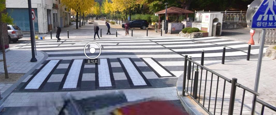
Nowadays, crosswalks are often drawn in an X shape to accommodate pedestrians.
And here we have an entire area designated as a crosswalk.
Posted by amapanda ᚛ᚐᚋᚐᚅᚇᚐ᚜ 🏳️⚧️ on 5 July 2023 in English.

There’s been an OpenStreetMap presence on Twitter and the Fediverse/Mastodon for years. And in the last few months, the @OpenStreetMap account on Mastodon/Fediverse has gotten much more engagement on Mastodon compared to Twitter.
The OSMF has had a formal policy committment to use open communication channels for 3+ years, but it’s important to also use closed platforms if it helps reach people. So where are the people?
As part of my work for the OSM Communications WG, I maintain some OSM social media channels. For several months, Mastodon engagenment has been much higher than Twitter. Here’s some raw data and examples.
(Here I show the number of retweets/boosts (🔁) and stars/likes (⭐) posts get on Mastodon (🐘) and Twitter (🐦))
The important OSMF post about recent Maxar imagery unavailability got about the same, ( 🐘 4🔁 3⭐ vs 🐦 5🔁 7⭐, but Mastodonians like OSMF internal posts about the 2023 Screen to Screen. 🐘 9🔁 5⭐ vs 🐦 1🔁 1⭐, or the post about the OSMF SSRE’s first year, got 4 times as many boosts/retweets 🐘 23🔁 17⭐) vs 🐦 4🔁 8⭐.
State of the Map is also a popular topic, with Mastodon toots out-performing Twitter tweets. From general “Have you been to SotM?” posts (🐘 12🔁 11⭐ vs 🐦 3🔁 6⭐) to requests for new host bids reach more people on Mastodon (🐘 16🔁 12⭐ vs 🐦 7🔁 23⭐
This analysis is just the tip of the iceburg. Compare the OpenStreetMap mastodon account to the OSM Twitter account to see more examples. Don’t forget: The “number of followers” on Twitter is 10 times higher than the on Mastodon (84K vs 6K), and yet Mastodon is reaching more people, and driving more communications.
Others in OSM have seen this. Pieter Vander Vennet showed how WeeklyOSM was increasingly linking to Mastodon, rather than Twitter. Geomob podcast episode № 171 described the “amazing” difference in engagement they got on Mastodon versus Twitter.