-
Diary Entries in English
Recent diary entries
-
Posted by FrontRangeUrbanEquestrians on 10 December 2023 in English.
A week ago, one of my riding companions lost her horse in a tragic traffic accident at a busy intersection. Now, the Colorado equestrian community is demanding change in our suburbs to prevent pedestrian, equestrian, and cyclist injuries and deaths. One of our starting steps is to map popular riding routes that use public roads so that our legislators can identify problem areas and work to resolve unsafe traffic conditions caused by inadequate infrastructure.
Spent all morning updating speed limits from 30mph to 20mph in Port Talbot, Goytre, Cwmavon, Margam, Sandfields and Baglan.
Posted by charles chilufya on 9 December 2023 in English.
Last updated on 19 September 2024.
A PRECIOUS STONE WORTHY CELEBREATED A CASE OF STATE OF MAP AFRICA 2023.

The State of the Map Africa (SotM Africa) is a bi-annual regional conference that celebrates the culture of open mapping, open data, GIS, and its impact across Africa. The OSM community in Uganda hosted the first SotM Africa conference in 2017. In 2021, It was hosted in Abidjan and Grand-Bassam in Ivory Coast. The 2021 conference planned in Nairobi, Kenya was virtually hosted (online). This year’s conference was hosted in Yaoundé, Cameroon under the theme “Open Mapping as a Support Tool for Local Development in Africa“ [https://2023.stateofthemap.africa/about] The OSM Africa community has rapidly grown in recent years and as a way of embracing Africanism, SotMAfrica has been practised since 2017 and is regarded as the biggest gathering for all OSM African communities. Again this year from 30th November to 2 December 2023 the African biggest gathering was hosted in Yaounde, Mbankomo - Cameroon.
Posted by Mwakisole Janeth E on 9 December 2023 in English.
Hello, my name is Janeth Mwakisole and I’m from Tanzania.
I had the opportunity to attend the State of the Map Africa conference in Yaounde, Cameroon from 30th November to 2nd December 2023. This conference was about celebrating and showcasing the culture of open mapping in Africa. I learned a lot about the significance of open mapping in supporting sustainable community development. One of the crucial things I grasped is the value of data-based decision-making. Open data is a dependable and efficient tool, especially in communities that have limited resources. By utilizing open mapping and the information it provides, communities can make well-informed decisions that optimize their scarce resources and contribute to long-term progress.
One of the things I found particularly interesting was how open mapping can contribute to climate resilience because it is related to my career background. I also learned about waste management and how it can be improved through open mapping. Of course, there are a lot of things to share, and I have mentioned only a few of them.
During the conference, I met and connected with people from different countries in Africa and worldwide. For example, I met Geoffrey Katerrega from Uganda, Kennedy Jomokela, and Charles Chifulya from Zambia, and many more from Cameroon and other parts of the world.
I had the opportunity to moderate and participate in the panels at the conference, which was a completely new experience. I’m grateful for the chance I was given, and I believe, through what I have learned at the conference, I’ll be able to make fruitful impacts in my community and further develop my career.

Dear OpenStreetMap Community and fellow mappers,
As we say goodbye to 2023, I reflect on a year of growth and development in the OpenStreetMap project.
This year has seen substantial increases across various metrics:
- Nodes: Increase of 731,936,003 since last year (9.09% annual increase, over 2 million daily)
- Ways: Increase of 83,077,150 (9.21% annual increase, over 200 thousand daily)
- Relations: Increase of 1,183,690 (11.37% annual increase, over 3,000 daily)
- Registered users: Increase of 1,161,850 (12.25% annual increase, over 3,000 daily)
These statistics, accessible here and here, not only quantify our growth but also demonstrate the dynamic evolution of our project.
Beyond these numbers, the real essence of OpenStreetMap lies in its community. The launch of our new community discourse has fostered more vibrant and quality discussions than ever before, thanks to the dedicated efforts of our moderation teams in maintaining a constructive and respectful environment. The migration of all old forum content was a major effort by the Operations Working Group.
The board, in collaboration with the communications working group, has enhanced transparency and engagement through more frequent blogging, and community consultations on major projects. We also updated our mission statement to better reflect the OSMF’s actual work.
Since late 2020, successive boards have been shaping the OSMF’s first strategic plan, informed by extensive feedback from OSMF members and the broader community. This plan, finalised in September, provides a clear direction on future endeavours in key areas like technical infrastructure, community development, institutional development, and financial governance.
Today I participated in the training on road classification where I gained additional knowledge on different types of road classification in Java OpenStreetMap (JOSM). training@hotosm.org

At present, farming_system is used in Nepal to mark bari and khet , referring to specific farming practices in the area. I am proposing to use this tag with jhum to mark farmland in NE India / Myanmar where traditional jhum shifting cultivation (slash-and-burn farming) is practiced.
These are fields which are essentially permanent farmland, but which are left to re-wild for some years before being used again. Contrary to some beliefs about the method, the entirety of the jungle is not used for this type of farming. Instead, it is always the same fields that the communities cycle between.
Expansion of this tag to include jhum could enable greater tracking of such fields as part of ongoing scientific analyses of this methods of farming and their impact on the environment. Use of the farming_system tag does not affect rendering, or interfere with any other tags. As farming_system is already in wide use in Nepal but otherwise unused, it is the ideal option for tagging jhum land use.
edit: Discussion on the tagging forum here: https://community.openstreetmap.org/t/proposal-for-farming-system-jhum/106877/4
Posted by spwoodcock on 7 December 2023 in English.
Last updated on 21 February 2024.

To GDAL or not to GDAL
GDAL is an incredible geospatial library and underpins so much of what we do, including our databases (PostGIS).
However, sometimes it might be a bit heavyweight for what we are trying to achieve.
Installing it as a base system dependency inevitably installs everything - there are no options.
Install size is especially important when building container images, that we want to be as small as possible for distribution.
GDAL in PostGIS
PostGIS uses GDAL for most of it’s geospatial processing, including reading and writing various geospatial file formats.
FMTM is starting to use FlatGeobuf format for various purposes (OSM data extracts, storing submissions).
It also uses a PostGIS database as part of the software stack.
So today I thought: why not just use the geospatial processing built into PostGIS for reading and writing flatgeobuf data?
The solution was surprisingly painless!
Database Access
First we need a way to access the database.
Posted by pedrito1414 on 6 December 2023 in English.
Activation info:
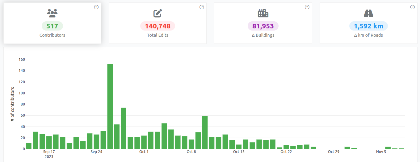
Activation: Libya Floods 2023
Activation Declared: Sep 14, 2023
Activation Concluded: Nov 9, 2023
Debrief Conducted by: Pete Masters, HOT, Activation Lead
Relevant statistics
Video showing the easiness of streetcomplete
Link to the original message in mastodon.social
Short video showing the easiness of using @streetcomplete to improve OpenStreetMap and all projects which rely on it e.g. #cyclosm
Link to a Peer2Tube video on urbanists.video
Feel free to spread the video to promote Streetcomplete use!
Introduction
Many paths, tracks and even small streets are missing from OSM. And yet, these paths are often used by Strava users, who upload their traces there. So I thought it would be interesting to use these data to improve OSM.
That’s why I wrote a Python program which, by analyzing Strava data, is able to detect missing paths in OSM, then generate files to create MapRoulette challenges so that each missing path can be added to OSM.
What is Strava?
According to Wikipedia, Strava is a website and mobile application used to record sports activities via GPS. Its members use devices such as a GPS watch or smartphone to record their running activities, and send these to Strava. Currently (2023), there are over 100 million members.
Strava heat maps
On its website, Strava publishes a heat map showing the aggregation of all its users’ tracks.
Example:
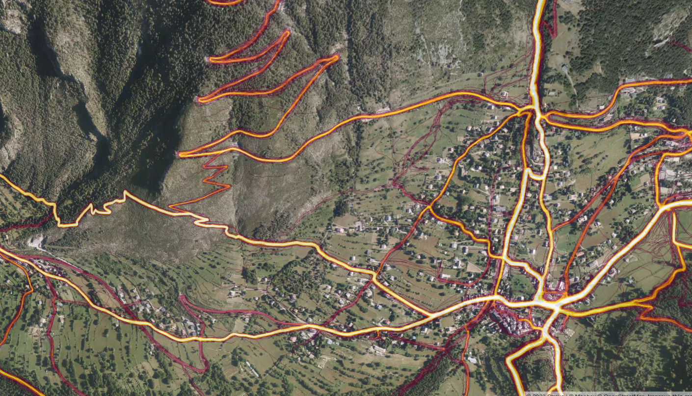
The more a route is ridden, the brighter its track appears on the heatmap.
Posted by Eden Oluigbo on 5 December 2023 in English.
Last updated on 10 December 2023.
👋🏼 Hello and welcome to my blog space where I share everything about my journey with Outreachy, HOTOSM and more. Thank you for joining me on this exciting journey! I am very excited to be part of the Outreachy program and If you’re interested in knowing the rest of my story, which I am willing to share it all :), please subscribe to my posts, so you get notified every time I publish a blog on my journey. Just like everything that ever existed, there’s always a beginning. So let’s zoom🔍 out a little bit to where it all began 😊.

Introduction
My name is Eden Oluigbo. I am a full-stack developer, artist and creator living in Abuja, Nigeria. I'm an open-source advocate and love contributing to the improvement of open source software. I started an active contribution to open-source projects in 2022. I joined different communities, made contributions and got PR merges (that excitement of having your PR merged never gets old haha😁).
Why Outreachy?

This is a cross post from the HOTOSM blog.
As Community Strategist and Research Lead at HOT, I would like to take a closer look with you all at the evolving landscape of OpenStreetMap (OSM) contributors, especially in the context of local knowledge and its crucial role in our mapping efforts.
Summary
Our recent study reveals a trend in local knowledge contributions in OpenStreetMap: a small but dedicated number of local mappers, making up just about 3% of contributors who are in the area mapping, is responsible for approximately 75% of the detailed mapping contributions.
This significant finding underscores the vital role of local knowledge and expertise in creating comprehensive and accurate maps, especially in humanitarian and unmapped/under-mapped regions. Despite a general decline in new OSM contributors, the impact of this core group of local mappers remains profound and indispensable for the future of the project.
We would like to engage researchers and mapping communities to unveil what are the implications of these numbers and the opportunities to use them to better support mappers.
The Spark of Inquiry: Simon Poole’s Analysis
Our journey began with Simon Poole’s important observation: a 20% drop in new OSM contributors. This sparked intense discussions within our team and motivated us to investigate further, particularly focusing on regions where HOT is actively involved.

Another year, another Pista ng Mapa 2023 in Tacloban City!
Hosted by UP Visayas Tacloban YouthMappers, it’s a gathering celebrating open mapping, data, and an unforgettable journey. I am grateful to the organizing team for the scholarship grant and the chance to present. Thank you, UP Tacloban Youthmappers, for the warm welcome and for keeping our surroundings pristine.
The conference was a three-day journey packed with eye-opening lightning talks. From Leanne Caye D. Obispo’s “Data: A Story to Tell” to Sir Denrazir Atara’s spatial analysis of tree species, each session was a revelation. Erika Del Rosario Pauline Jen Madrona’s drone training and Oriel Jay Ibañez’s insights on community development through drone imaging were inspiring. Sir Ben Hur Pintor’s discourse on data management and Ms. Dinnah Feye Andal’s introduction to Mapillary were eye-openers. And oh, the endless field trip—such a blast! where I can say I shall return to Tacloban
Meeting old friends, making new ones on social nights, connecting with mentors again like Sir Mikko Tamura, Ms. Feye Andal, Leigh Lunas, Sir Ben Hur, and Sir Aimon, and connecting with the local YouthMappers chapters were a highlight! This was my 2nd Pista ng Mapa 2023, a great adventure with a small team with Dora (Me), yet the knowledge gained, networks built, and friendships forged were beyond measure. Here’s to hoping next year brings even more from our chapter.
I look forward to creating new memories and deepening my mapping passion at the next Pista ng Mapa (also SotM, manifesting!). Huge thanks to everyone who made this event an unforgettable experience!

Thank you

Asante sana
Your participation in 2023 GIS Day Conference was hugely appreciated
"Geospatial technology stands as a cornerstone for fostering a robust digital economy in Tanzania,serving as a catalyst for achieving sustainable development that will secure a prosperous future for forthcoming"
Dr. Moses Nkundwe Mwasaga, DG ICT Commission
Throughout the conference, we witnessed over 200+ participants gathered at the Tanzania Commission for Science and Technology (COSTECH) in Dar es Salaam to exchange knowledge and participate in dialogue on utilising geospatial technology for sustainable development in Tanzania.
The conference brought together geospatial enthusiasts, leaders, and practitioners across industries, the private and public sector, academia, and civil society organizations to promote changes that can be made at the community, producer, and government levels for sustainable development.
Engaged participants included:
Idk wtf this shit is or why I’m on here trying to figure it out.. but hey, whatever!!!🙃🙃😻😻🤣🤣🤦🏻♀️🤦🏻♀️🌻😸👀
A few years back, I successfully led a crowdfunding effort to raise £975 to purchase scans of the 1970s / 1980s 1:50k topographic map series of South West Africa / Namibia from a commercial map archive. It was a great success and I put them online: https://namibia-topo.openstreetmap.org.za/
Recently I have been speaking to the archive again about purchasing similar map series for other African countries. The map series vary per country from the 1960s to 1990s. Many were created with support from the United Kingdom’s former Directorate of Overseas Surveys (DOS).
The 1991 1:50k Topographic series of Swaziland (now Eswatini) published by the Swaziland’s Surveyor General is available. It is made up of 31 sheets in total. The scans are supplied clipped and unclipped. Total price is US$ 400 for the scans.
It would be fantastic to get these maps online. Would you be willing to support this purchase?
Posted by maplemoths on 1 December 2023 in English.
Hello, i’m maplemoths. This is my first diary entry, and i decided it’d be fun to discuss OSM topics occasionally here.
What have i been mapping recently?
I’ve been doing tons more mapping recently, because it’s pretty fun. It’s nice to just listen to music/twitch stream vods, and just map. Here’s what i’ve mapped recently.
Hawai’i
Most recently, i’ve been mapping in Hawai’i. A large amount of my edits actually are in Hawai’i in general, because i used to live there. Specifically, i’ve mostly been editing in the city i lived in, Hilo. When i first started mapping in i believe September of 2022, Hilo’s map quality wasn’t super good. Lots of missing landuse or POIs, lots of stuff that was all offset from eachother, the polygons were really messy, etc. But, i feel like there’s been tons of progress! I’ve been working on making things better, and there’s been some progress from others. There’s been more landuse, i cleaned up lots of the messy/incorrect polygons, and i’ve also micromapped the zoo right outside of the city, but i’ve also done some other stuff in the area.
Plains, Georgia
A lot of times, i map an area because something interesting has happened there, or that it’s significant for an interesting reason. Examples include me mapping Oleona in Pennsylvania because the area was the site of a small failed Norwegian colony, and yes, Plains, Georgia. It’s a small little town right in the south of Georgia that’s famous for being the hometown of US president Jimmy Carter, so i decided to map it! I mostly did landuse and cleanup, and it was quite fun! If you’re wondering, i did not map the town because of Rosalynn Carter’s death, i started the project a month earlier but only finished it after.
What do i plan to do next?
This section is for stuff i want to get to, and maybe i can get some help on if you want!