We had a meeting with Arnalie on the membership drive in OSMF.
Diary Entries in English
Recent diary entries
Posted by Brazil Singh on 14 February 2024 in English.

YouthMappers at Eastern University recently organized a dynamic and engaging day-long session focused on the theme ‘Connecting with Community: Let’s Switch to Mapping.’ The event, held on February 07, 2024, at Eastern University, brought together students, and community members to explore the power of mapping in community development and engagement. The session featured a diverse range of topics, including Community Development, Leadership Training, Women’s Participation, Problem-Solving, Kobo Toolbox, Data Collection and Analysis. Led by Youthmappers Regional Ambassador, Amena Rashid Bania, the session provided valuable insights and practical skills for participants to enhance their understanding of mapping technologies and their applications in community initiatives. In addition to the informative sessions, the event also included hands-on workshops on Mobile Mapping conducted by regional ambassador Nishan Ariyal, and Mapping Techniques led by Brazil Singh, President of YouthMappers at Eastern University, Bangladesh chapter. Brazil Singh, a prominent figure in the OpenStreetMap (OSM) community, is recognized as an Open Mapping Guru Fellow in the Asia Pacific Region, bringing a wealth of experience and expertise to the session. Guest Speaker Sawan Sahriar, regional Ambassador of Youthmappers, graced the event with his presence and delivered an inspiring talk on OpenStreetMap and Mapping Tasks. His insights and knowledge added a valuable dimension to the session, inspiring participants to explore the possibilities of mapping in community engagement.
Posted by arnalielsewhere on 14 February 2024 in English.
my prolonged OSM diary about my experienced as an OSMF board member. Apologies for the delay!
Some background and tips to prepare as a board member
I joined the OSMF Board in Dec 2022 and this is my first time to hold a board member position! You can check my manifesto and answers to board election questions. I’d like to go back to this to check my progress and what needs to improve.
Since it is a new role, it really is intimidating at first! Even though I have talked with other open community and geo board members, it is different once you are in!
Some of the best tips I got are:
- Talk with leaders and people you know who have board member experience, learn from them and would be good if they can support / mentor you :)
- There is a free board member essentials available online (e.g. this Nonprofit Board Essentials from disasterready.org) so better try it and have an assessment of you board member potentials (don’t get too pressured, you will learn as you go!)
- Be a board member while you still have the time and capacity :) I am a full time mother and working woman so it was a hard decision to make; but then I realize, if I want to be a board member, I’ll better do it now since I have the capacity and interest! :)
- Two years seems like a long time but not really! You will have ideals and goals so better make that best out of it!
- Also remember, change takes time. Don’t overfrustrate yourself ;)
What happened in 2023, then?
Last year came by so fast. I am not so proud of what I have accomplished as a board as I have had some health challenges. It was a learning experience (the success and failures) for me!
With support from fellow board members, working groups, and community members, in 2023, we have accomplished:
1.Local Chapters Application revisions
Posted by arnalielsewhere on 14 February 2024 in English.
Providing updates! The OSM Wiki of the OSMF Membership Drive Campaign 2024 Plan is in the wiki: osm.wiki/OSMF_Membership_Drive_2024
We will also provide updates and have a space for feedback in the Community Forum using this thread: https://community.openstreetmap.org/t/updates-osmf-membership-drive-campaign-2024/109280
First Volunteers Meetup - 3 Feb

After a successful and overwhelming response on the Call for Volunteers, we held our first volunteers meetup last 3 Feb!
Posted by Longhorn256 on 13 February 2024 in English.
Last updated on 19 February 2024.

I’m currently in the process of tagging historical highways in Venango County. Unfortunately, there’s no online database or public PennDOT sources for old legislative routes in Pennsylvania other than historical County Type 10 maps. I will attempt to use this diary to create a listing of old legislative routes and their modern LRS equivalents within Venango County as I add the appropriate old_ref:legislative tags to OpenStreetMap and add the road to Open Historical Map.
History and Description
Legislative routes were formed from the Sproul Road Bill in 1911 and existed until 1987 when the current location referencing system became in use.
Database
This week’s weeklyOSM #707 wonders aloud whether Flørauden is the most heavily tagged node in OSM. Why wonder when OSM query engines like QLever can tell us for certain?
In fact, at a mere 283 tags, this lighthouse is a featherweight compared to the top ten nodes, which are all place=country nodes weighed down by linguistic and diplomatic considerations. The most heavily tagged node of any kind has a well-known name, alt_name, official_name, and old_name in many languages.
Excluding place=country, most of the top ten nodes are place=city and place=continent nodes. But the node in sixth place caught my attention: some 250 tags on a children’s clothing store, mostly about payment methods. One is only left to wonder if a customer, paralyzed by all the options, may resort to bartering. This vandalism was removed three weeks ago, but QLever hasn’t updated to a newer Turtle extract that contains the fix.
Excluding all place=* nodes, the now payment-ambiguous clothing store, and a duplicate Sri Lanka node that was accidentally stripped of its place=country tag (now fixed)… the other most heavily tagged nodes are all seamarks – lighthouses and lighted beacons.
Flørauden was 16th among seamarks until it shot up to the top a couple weeks ago. Now, with 27 different seamark:light objects tagged on it, no other seamark comes close to it in the number of seamark:light:* subkeys.
This lighthouse may not set a record, but it does illustrate why the seamark tagging scheme unusually relies on numbered subkeys instead of parallel semicolon-delimited tags. The street parking tagging scheme used to do something similar before we simplified it a couple years ago, but back then, even a notoriously well-signposted street could only muster a puny 60 tags.
Now all we need is for Null Island to become a seamark, island nation, and international security incident.
What appears are two separate man-made geoglyphs, 300m x 500m (human) and 200m x 200m (bull), of what appears to be etched on a gently graded terrain is a human and a bull oriented north to south. The two figures is targeted with several concentrically oriented Nazca lines.
14°47′38″S, 75°4′15″W -14.7940031, -75.0709680 Nazca, Province of Nasca, Ica, 11401, Peru
The figures suggest a man-made geoglyph of a human being chased by a bull which appears to be in pursuit of him It is very unclear why the bear is chasing him. The man appears to be carrying a blanket, wearing lose fitting outfit and wearing shoes. The bull behind him has long pointy horns and appears to be drawn as if he is chasing him.
Awaiting better mapping to confirm additional linework.
Along with the inhabitants, bulls have been recorded in these local areas.
Posted by Raquel Dezidério Souto on 12 February 2024 in English.
Last updated on 15 February 2024.
Information for the disaster risk reduction (DRR) in the Municipality of Maricá (Rio de Janeiro, Brasil)
Contextualizing
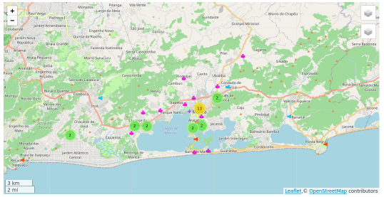
This web map is part of the development research that aims to provide a mapping platform for official and collaborative data, within the scope of disaster risk reduction (DRR), as this type of catastrophic events is increasing its frequency of ocurrence in the state of Rio de Janeiro (Brazil) in the last years. The municipality of Maricá is the pilot area of interest (AOI). The reader can also visit the dynamic map of this same area of interest at uMap.
The mapping and development of the collaborative platform are coordinated by Dr. Raquel Dezidério Souto (IVIDES.org), in cooperation with a group of mappers of the YouthMappers UFRJ. To keep contact, please, send an email to ivides@ivides.org or answer this form.
Yesterday I mapped two parks along 43rd which I decided would be the final portion - 43rd does continue east of I-435 but in the interest of some kind of coherent boundary to my city mapping, I’m keeping it within the bounds of I-435. The parks had several amenities like sports courts, picnic shelters etc. On the way between one park and another, I encountered a bar owner who wanted to chat. He noticed me taking a photo of a downed pedestrian signal button and complained about all the accidents that happen outside his bar - including the one that led to that particular damage. I reported it on the city’s 311 app and asked him if he was aware of the app - he wasn’t, so I showed it to him in case he wanted to report more accident damage in the future. A kind old man driving through one of the parks asked me if I was with Parks and Rec, and said he hoped they would add a public restroom to the park one day. I told him I agree, but explained I was just doing a hobby and not with Parks and Rec.
Several times when I have added milk churns stands to the map in Latvia, I have noticed ponds in the vicinity of farms. For a while, not knowing much about Latvian culture, I thought they were for keeping fish for a balanced diet.
But today, after having added two more MCS, I decided to ask my trusted Latvian on Instagram, the lady who has the account which features Latvian milk churn stands. She explained that rural farms often still have a sauna and that people also like ice water bathing, so it’s convenient to have your own pond on the farm. The little sauna hut (not mapped much in Latvia, but in Finland as building=sauna, building:use=sauna and building=sauna_hut) is often surrounded by trees and a bit away from the farm house in case of fire.
I had added a few ponds here and there, but I’m delighted to see how many are already mapped in Latvia - over 14,000!

Every day is a school day.
Posted by umbraosmbr on 11 February 2024 in English.
Mapping and Geoprocessing Course with QGIS (online / 100% Free)
Curso de Mapeamento e Geoprocessamento com QGIS (on-line / 100%
Gratuito)
This is an extension project of the Geography Course at UNESPAR (State University of Paraná), with the purpose of qualifying participants in mapping and geoprocessing using QGIS. This course is certified (up to 60 hours, according to participation) and in this way, we wish to bring knowledge to teachers, researchers, students and the community in general, always in need of new skills to assume their space in the workplace.
CONDITIONS TO TAKE THE COURSE: Have a computer (with good storage and processing capacity) with internet access;
Have basic computer knowledge (know how to unzip a folder in Windows, copy and paste procedures, etc.);
Be able to attend online classes on Sunday mornings (once a week). Set aside one day a week to watch the theoretical video lessons and practice;
participate in a TELEGRAM group, to ask questions and receive information relevant to the classes (invitation link https://t.me/+OqUWHvvnQldjYjgx);
Participate in the (online) classroom;
It is recommended to use a handheld mouse.
REGISTRATION LINK: https://encurtador.com.br/afFY1
DATA: From March 10th to May 19th, Every day from 9:00 am to 11:30 am Horário of Brasilia.
Hello hello strange website I do not fully understand! I have begun mapping out my Town! The grand town of Northampton! I saw a lot of the suburbs, and even parts of the town centre were missing residential housing features, so I began adding buildings on a road I know quite well as I used to live there. I know I missed a few sheds, but I am not about to guesstimate their locations under trees. Cheers!
I’m just back from a holiday in Malta where I obviously mapped a lot. I made it to #3 in number of changesets in the country which was not terribly difficult.
Something went wrong with my SIM card as soon as I landed, so I had no mobile internet, but I had downloaded Malta on OSMAnd beforehand, so I was good. And there is free wifi on public transport which I availed of excessively.
I added and modified all kinds of things: post boxes (also updated collection times which seems to have changed generally on the island of Malta to Mo-Sa 7:00), defibrillators, ferry terminals, shops, museums, bus stops, charging points, and because it’s me, jostle stones, urine deflectors and drawbar slots. In Mdina, I could actually see the jostle stones in action! I was so excited, I made a little Short for Youtube, but that corner didn’t have a guard stone, but was chamfered and had a metal protector: YouTube Link
Looking at neis-one for Malta and looking up some of the mappers, it seems that Malta is mostly mapped by tourists and these days. You can tell (at least it was my impression) that by what is mapped as well: Areas that are frequented by tourists are mapped much better (I added some post boxes that I spotted from the bus going through areas where tourists don’t get off the bus). Things that are of interest to tourists are mapped, like museums, hotels, bars, beaches and shops whose brands are known globally.
Even before I had set off, I had noticed many hiking trails mapped. I only tried out one heritage trail, and found it poorly signposted. If I hadn’t had the route marked out on OSMAnd, I wouldn’t have known where to go, I think. I noticed some bits missing in the relation and contacted the original mapper who turned out also to be a German tourist. I added some of the other features along the trail. I don’t know who mapped the other trails; I had initially thought that maybe the tourism department of Malta had done it, but I haven’t looked into it.
Posted by Raquel Dezidério Souto on 10 February 2024 in English.
Last updated on 17 April 2024.
Motivation and Scope
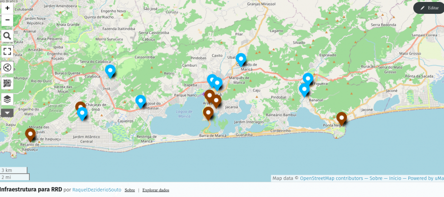
Workflow to map points of interest (POI) in OpenStreetMap (OSM) from a comma-separated values (.csv) file and generate a dynamic web map.
It is important to highlight that this procedure can be carried out by novice mappers and that it is more suitable for mapping little data, for example, schools, health posts, emergency sirens etc., confined to an area that could be, for example, downloaded with iD or JOSM.
To import a larger volume of data into OSM, you need to be an experienced mapper (intermediate or advanced level), to document the procedure on the OSM Wiki and to obtain community approval. This case is not the focus of this tutorial.
Materials
For this activity, you will need:

As we announced at the beginning of 2023, OSMCha has become a charter project of OpenStreetMap US. After almost 10 years of being generously hosted by Mapbox, OSMCha is now moving to a new home at the OpenStreetMap US. Going forward, OSMCha will be run on infrastructure owned and operated by OSM US. We are excited about this new chapter for OSMCha and to work with community members and organizations to grow the project.
In the last few months, the Development Seed team has been working on modernizing the infrastructure code behind the OSMCha services, closely working with Mapbox. As the infrastructure built by Mapbox was designed almost a decade ago, this was a required step to execute the migration. It is also bringing more efficiency in terms of cost and performance.
The migration will be done next Tuesday, February 13th. Starting from 15:00 UTC, OSMCha’s API will be read-only or unavailable for a few hours.
We are grateful for the support provided by Mapbox throughout the years. Mapbox was the first company to believe in the OSMCha proposal, funded the initial development and continued running the project providing infrastructure and critical maintenance. Their support was crucial in making OSMCha a core tool used by the OpenStreetMap community, everyday. We are now seeking new partners to help us continue to develop and expand OSMCha. If you’d like to support OSMCha directly, you can contact the OpenStreetMap US staff at team at openstreetmap.us.
Posted by umbraosmbr on 9 February 2024 in English.
Last updated on 11 February 2024.
Mapping and Geoprocessing Course with QGIS (online / 100% Free)

Curso de Mapeamento e Geoprocessamento com QGIS (on-line / 100%
Gratuito)
This is an extension project of the Geography Course at UNESPAR (State University of Paraná), with the purpose of qualifying participants in mapping and geoprocessing using QGIS. This course is certified (up to 60 hours, according to participation) and in this way, we wish to bring knowledge to teachers, researchers, students and the community in general, always in need of new skills to assume their space in the workplace.
CONDITIONS TO TAKE THE COURSE:
-
Have a computer (with good storage and processing capacity) with internet access;
-
Have basic computer knowledge (know how to unzip a folder in Windows, copy and paste procedures, etc.);
-
Be able to attend online classes on Sunday mornings (once a week). Set aside one day a week to watch the theoretical video lessons and practice;

Ever since visiting Mount Lassic and then making edits in the region, I’ve had this nagging difficulty: What to do with a mountain whose high point is named differently? Mount Lassic has three peaks, the highest is called Signal Peak. I eventually mapped its survey point, which is also called Mount Lassic, and hoped that was done. (Apparently I shouldn’t map survey points except at the exact point indicated, so I’ve done this WRONG. I’ll just name a peak “Such-and-such Benchmark” then. Except a benchmark is specifically a vertical control and most at peaks are horizontal controls. “Such-and-such Triangulation Station” gets a bit long. Oh, the humanity!) Unfortunately, if one searches for the mountain, one only gets the Mount Lassic Wilderness and the Mount Lassic Trail, but there’s no hint that this goes to the high point of Mount Lassic. It goes, in fact, to “Signal Peak”.
Other places where there’s a named high point (peak) different from the main mountain are Marble Mountain (with Black Marble Mountain the high point). Someone seems to have simply marked a lower peak as Marble Mountain. If one does this, there’s a bit of a debate if it is the highest white peak or the most prominent white peak. Mount Konocti with high point Wright Peak. Currently both are marked close to the high point, but the main mountain has been given a lower elevation so doesn’t show often, but it is searchable.
Yesterday, I reached the point of one million map changes and twenty-thousand changesets. Leading up to this milestone, I tracked my progress on How did you contribute to OpenStreetMap? and carefully planned to make a single edit that would be my one millionth in my twenty-thousandth changeset. I eventually made a gimmicky changeset referencing my first mapping experience. Mission accomplished! However, despite the impressive numbers, my initial sense of accomplishment faded, replaced by nagging existential questions. Have the countless hours I devoted to OSM truly been worthwhile? Why have I been doing this? What is it exactly that I have been doing? … What is OpenStreetMap, really? And there it is, a question that seems very simple, but is not. It is the same question that hides far below the surface in Xvtn’s OSM Iceberg Meme. Inspired by this meme, user rtnf put it this way: “Is it a map? A dataset? A community? A trademark that encompasses an entire ecosystem consisting of the dataset, the tagging scheme, the rendering infrastructure, and the subculture around its mappers, developer-mappers, and third-party data consumers?? What is OSM, really?”
When you invite someone to go to openstreetmap.org for the first time, the first thing they read is “OpenStreetMap is a map of the world”. The next thing you usually want to explain to them is that OpenStreetMap is NOT (just) a map of the world. We then continue showing off different rendering styles, different editors, different tagging schemes … We pride ourselves being part of a secret society, where only the sworn in know what it is actually about. We giggle when we see the Iceberg Meme because it is “so true”. We say things like: “If you have been doing this for years, you will understand”. All of this without being able to answer a very simple, fundamental question: What is OpenStreetMap?
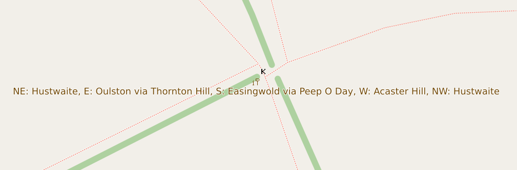
Although the raster maps at maps.atownsend.org.uk support zoom levels up to 24, until recently I’ve not made much use of that for showing extra data. However, there is a lot of room at these high zoom levels - as the picture above shows, enough for all the directions on this signpost here.
The name is shown as normal at lower zoom levels, then as you zoom in the directions are shown too, as you can see here.
1st Time Learning about QGIS and Open Street Map through Digital Mapping Workshop on Palang Merah Indonesia (Indonesian Red Cross), North Jakarta Branch