Hello my name is Lucas Shepard Brewer and I go to Jesuit Highschool. I loved mapping in turkey today!!! I do mapping everyday!!!! WHEN I SLEEO WHEN I EAT WHEN I RUN EVERYWHERE!!!!
Diary Entries in English
Recent diary entries
Posted by arnalielsewhere on 11 March 2024 in English.
Last updated on 7 October 2024.
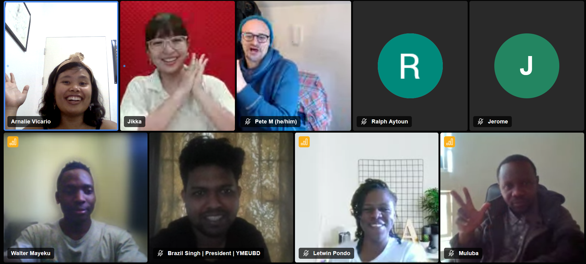
In 2 March 2024, various OSM contributors and community members/leaders gathered together for the Local Chapters and Communities Congress! It was my pleasure to share a short update about HOT where I work as an Online Community Engagement Lead.
My slide presentation is here. Recordings are now uploaded in Youtube :)
Just a point to make that I shared about the HOT and its community, and not the HOT as an org. HOT Annual reports are available here.
How to get involved in HOT?
There are three general ways to get involved with HOT:
- mapping in your own time,
- participate in a HOT Working Group/s, and
- contribute to tech.
So how do we engage with the community / contributors at HOT?
Since lots of different community members and leaders were there in the Congress, I took the opportunity to share and highlight how we foster a collaborative and inclusive space in HOT and channels

After FOSDEM I was hooked again to contributing to OSM. I started slowly by using StreetComplete and did more than 700 suggestions and edits for a months. Now I am looking into using the editor to be able to add missing spots, especially pubs and toilets.
If there any any other Englis speaking enthusiasts in Prague, I am always open for doing a map walk combined with a pub visit.
Found by Harrison Grossman and Caitlyn Faulkner

Yesterday morning, our OSM community in Metro Manila, conducted an AlayData event for the quarter. We gathered to celebrate Open Data Day, focusing on open geopsatial data from OpenStreetMap, and give ourselves opportunities to socialize and get to know other contributors, sharing stories and experiences, and a chance for hands-on learning with new tools.
Among the things that our community learned from a “getting to know you” survey we did last quarter, is the high interest in other aspects of the OSM movement: like field mapping, photo-mapping, and getting familiar with other tools available from the OSM ecoysystem, and to more casual opportunities to contribute other than arm-chair mapping.
The volunteer group was sub-divided into three teams of their choice:
- Galúgad - folks also on foot, using FieldPapers, for a no-tech mapping approach. In Filipino, “Galúgad” means travelling to explore, or search for something.
- Tahák - folks on foot, using StreetComplete_EE (SCEE). “Tahák” in Filipino means to pass through a new or unusual path.
- Padyák - folks on HPVs (in our case, just bikes), to collect ground-level photos, to support or augment map editing. “Padyák” in Filipino means to stomp, and by extension, to pedal or push with your foot.
Initial results
Here’s the latest heatmap of recent edits made in the area:

I have created a web-based tool to easily and intuitively obtain the access token needed to make most requests to the OpenStreetMap api.
It is hosted courtesy of Interactive Maps.
The tool walks you through the process of obtaining such a token. It is useful for those writing server-side software that communicates with the api.
I created this tool because there is no other simpler way to authorise server applications. Current ways require running code locally.
It is available here: https://tools.interactivemaps.xyz/token

In case you might have not yet noticed, my current project on OSM is to cover the entire remainder of Vancouver Island with woodland data. I started with my home area of the Comox Valley and am radiating out from there in all directions, eventually finishing up with the area around Cape Scott. Every patch of forest I find in aerial imagery, no matter how expansive, even if the trees are small, will be added.
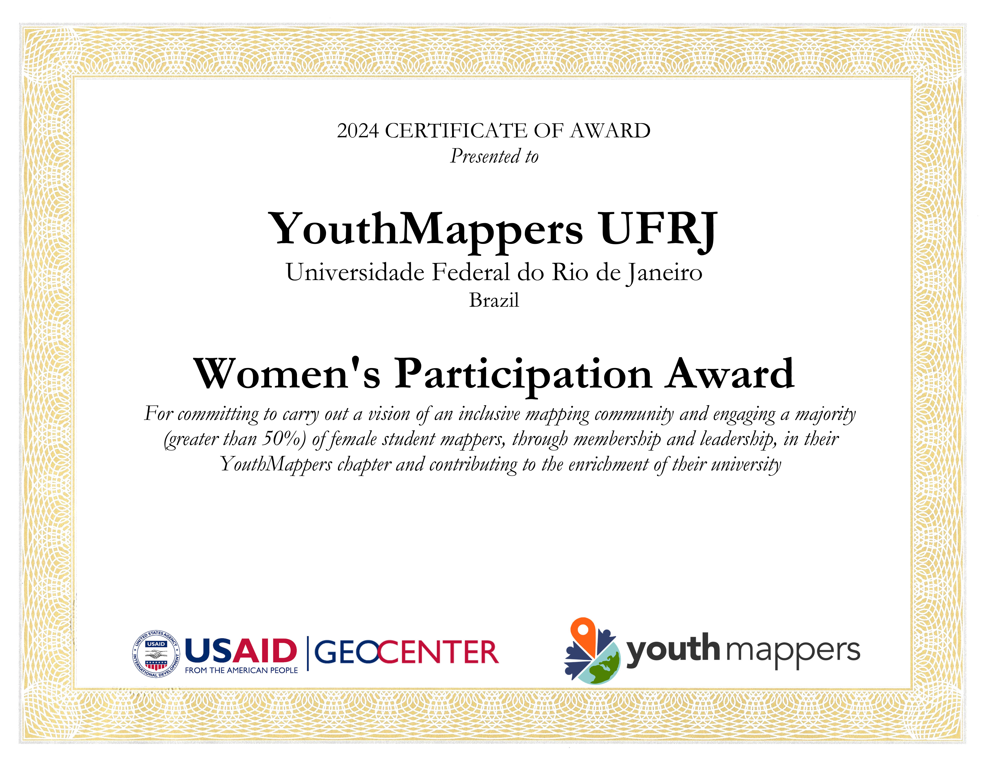
✔ YouthMappers UFRJ receives the Women’s Participation Award!
✔ YouthMappers UFRJ recebe o Women’s Participation Award!
✔ Our participation in the Open Data Day YouthMappers at UFBA 2024
✔ Nossa participação no Open Data Day 2024 do YouthMappers at UFBA
✔ Web map do mapeamento colaborativo para redução de riscos e desastes (RRD)
✔ Web map of colaborative mapping for the Disaster Risk Reduction (DRR)
✔ Mapear POI no OpenStreetMap e exibir dinamicamente com uMap
✔ Mapping POI in OpenStreetMap and displaying dynamically with uMap
✔ V Olimpíada Brasileira de Cartografia incluiu o OpenStreetMap como parte de sua etapa prática
✔ V Brazilian Cartographic Olympiad included OpenStreetMap as part of its practical stage
✔ Geocodificação com OpenStreetMap
✔ Mapeamento humanitário e OpenStreetMap
✔ Nossa participação no State of the Map Brasil 2023
✔ Atualização dos dados populacionais dos municípios brasileiros no OpenStreetMap
Posted by Raquel Dezidério Souto on 9 March 2024 in English.
Last updated on 30 April 2024.
✽✽ Women’s participation is recognized
The international project YouthMappers awarded the YouthMappers UFRJ Chapter (Rio de Janeiro, Brazil) for promoting women’s participation in its activities and organization, corresponding to more than 50% of its membership.
The YouthMappers UFRJ Chapter is an initiative of open collaborative mapping, that results of a partnership between the Virtual Institute for Sustainable Development - IVIDES.org and the Laboratory of Cartography - GeoCart-UFRJ, chaired by Dr. Raquel Dezidério Souto.
On this International Women’s Day, we dedicate this award to all girls and women, hoping that they can achieve their goals!
Our participation in the Open Data Day YouthMappers at UFBA 2024
Nossa participação no Open Data Day 2024 do YouthMappers at UFBA
Web map do mapeamento colaborativo para redução de riscos e desastes (RRD)
Web map of colaborative mapping for the Disaster Risk Reduction (DRR)
Mapear POI no OpenStreetMap e exibir dinamicamente com uMap
Mapping POI in OpenStreetMap and displaying dynamically with uMap
V Olimpíada Brasileira de Cartografia incluiu o OpenStreetMap como parte de sua etapa prática
V Brazilian Cartographic Olympiad included OpenStreetMap as part of its practical stage
Geocodificação com OpenStreetMap
Mapeamento humanitário e OpenStreetMap
Nossa participação no State of the Map Brasil 2023
Atualização dos dados populacionais dos municípios brasileiros no OpenStreetMap
Posted by Raquel Dezidério Souto on 8 March 2024 in English.
Last updated on 9 March 2024.
An event to strengthen alliances between mappers from Brazil and Africa
Between March 2nd and 5th, 2024, the event OPEN DATA DAY - Communities mapping communities: Brazil-Africa connection was held in Salvador (Bahia, Brazil), with the participation of Brazilians and Africans, who presented special keynotes and case studies on collaborative mapping, on the themes of sustainable development, gender equity, adequate housing, humanitarian mapping, disaster risk reduction and urban planning.
The YouthMappers at UFBA, producer of the event, also held mapathons, or mapping marathons, in the format of hybrid workshops, where participants mapped collaboratively on-line, using the editor iD for OpenStreetMap.
The YouthMappers UFRJ participated of the event, with the special keynote Collaborative mapping for disaster risk reduction - Case study: Municipality of Maricá (Rio de Janeiro, Brazil), given by its president, Dr. Raquel Dezidério Souto (IVIDES.org).
WATCH the RECORED VIDEO (in Portuguese and English), clicking here.
READ The PDF PRESENTATION FILE (in Portuguese and English), available here.
KNOW about this case study of collaborative mapping here.
Posted by radiotrefoil on 8 March 2024 in English.
Last updated on 4 April 2024.

Introduction
I am writing this tutorial because adding wireless connectivity to the cheapest hobbyist RTK module (Ardusimple simpleRTK2B) is very useful but not trivial for those inexperienced with electronics, and Ardusimple closed down their forums for… some reason. Hopefully this is something anyone can follow to make RTK more accessible to the general hobbyist mapper.
This entry is building on from my previous diary entry “Affordable, High Quality 360 Street Level Imagery using GoPro Fusion and Ardusimple”, I have now been using the rig for a couple years and it is holding up very nicely.
A quick summary is that I used the simpleRTK2B with my phone and GoPro Fusion 360 to make a very cheap and ultra portable street level imagery rig, for Mapillary or Kartaview. It can be used handheld or mounted to a car or bicycle.
The last survey I went on, whilst mostly fine, did bring up some issues regarding the reliability of the USB OTG data connection. This has always been a weak point of the rig in other ways because;
- the USB connection would drain my phone’s battery and make it difficult to charge the phone simultaneously whilst surveying, unless using wireless charger
- the phone always needed to be in close proximity to the simpleRTK2B
- too easy to accidentally disconnect
- The OTG adapter is wobbly in the type-c port
As my Android app of choice “SW Maps” permits a bluetooth connection for the NTRIP corrections, it was the obvious way to go.
Bluetooth module choice
Ardusimple sells the Bluetooth XBEE module for the simpleRTK2B for €34 which is quite expensive. I know you’re reading this Ardusimple! Third party Bluetooth XBEE modules are somewhat cheaper (around $20 AUD), however I had a generic bluetooth UART module laying around so I decided to just solder it in. Similar ones are quite cheap to buy new, for example the arduino HC-06 module goes for around $10 AUD.
Connecting it up

Added sidewalks south of Center Avenue between Hazelwood and Hiland, north of ORB/PA-65. Connected sidewalk to previous additions from Ben Avon.
I plan to extend coverage north of Center Avenue within Emsworth, and south of ORB/PA-65.
Added some parking lots here and there where most obvious, and cleaned up the area around Camp Horne Road & ORB intersection. This area could likely use some more work.
Realigned buildings here and there based on updated aerial photography. Might make another pass because there are quite a few that seem to be several meters out of alignment. I’ll have to check the original data these were derived from, but at least so far it seems that the PEMA imagery is the most accurate and precise available. I’ve cross-checked several notable points against the Allegheny County GIS viewer to confirm alignment to the best of my ability for now.
(All images via WikimediaCommons)
So, I went on a little outing with a friend to look at some historic/ folkloristic sites that I hadn’t been to before. One of them was an old monastic site where there is still a working church with a holy well (place_of_worship=holy_well) and high cross (historic=high_cross) nearby. When we went to the holy well/ high cross site, I was delighted to see that the site also had a rag tree which hadn’t been recorded on the government’s Historic Environment Viewer.
 Now, there could be several reasons for that which I won’t go into, but it reminded me that rag trees were something I had wanted to map, but of course, there was no tagging scheme.
I had mapped some previously using just natural=tree with various other tags, but I thought I needed a tagging scheme that was applicable to other countries and cultures as well.

Today marks a milestone in the development of OpenStreetMap NextGen. After months of rigorous development, I conducted the 1st OpenStreetMap NextGen performance benchmark, a crucial step towards realizing the vision of a more robust, efficient, and user-friendly OpenStreetMap.
The focus of today’s benchmark was on evaluating static and unauthenticated requests. Since this core functionality is unlikely to change significantly during future development, it’s the perfect time to test it.
Future benchmarks will focus on timing authenticated requests as well as API 0.6.
What was measured
The benchmark analyzed request processing speed, excluding network and client latency. Both osm-ruby and osm-ng support the X-Runtime response header, which tracks how long it takes to process a request and generate a response.
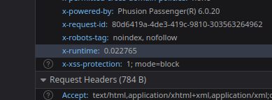
Here’s a general breakdown of a typical static request processing:
2720 m
3520 m
3050 m
Peak Forest
Posted by spwoodcock on 5 March 2024 in English.
Last updated on 6 March 2024.

See pt1 of this series here.
See pt2 of this series here.
A Long Overdue Release
The goal with the Field Mapping Tasking Manager (FMTM) was to adopt an agile development style, making a new release around once per month.
3 months have passed since the last blog post and there was no FMTM release in between!
What gives??
Well, the team has been working extremely hard simplifying usage of FMTM and making it much more usable.
It’s been hard to find a good point to stabilise a release due to so many great and rapidly developed updates!
From this release onwards we plan to follow through with a new version increment every month. Look out for version 2024.4.0 next month.
Public Beta Now Live
- The main goal we have been working towards is releasing a public beta this month.
- The public beta for FMTM is now live on https://fmtm.hotosm.org
- The idea to to have the public test out it’s functionalities & definitely break a thing or two!
- With your valuable feedback we want to make FMTM the best it can possibly be 🙏