OpenStreetMap logo OpenStreetMap

Diary Entries in English

Recent diary entries

Welcome to my fourth OpenStreetMap NextGen development diary.
Sorry for being a day late! I wanted to finish up one of the new features which caused this small delay. ✨

🔖 You can read my other development diaries here:
osm.org/user/NorthCrab/diary/

🐙 My work is available publicly on this GitHub repository:
https://github.com/Zaczero/openstreetmap-ng

GitHub stars counter

Let’s summarize the last week’s work:

Client-side Trace Images

While migrating the traces functionality, I came up with an amazing and seemingly obvious idea. Why not make trace images SVGs and render them client-sided? This feature has few significant advantages: even faster trace uploading, no additional disk usage, unlimited customization, infinite resolution, faster page loading. And so here it is:

See full entry

Posted by Eden Oluigbo on 8 April 2024 in English.

Not A Goodbye!

Two friends waving at each other

This is the Closing Chapter! However, the story continues😀

My friend (and colleague) Ola messaged me and asked, “Eden, how do you feel, that your internship at HOTOSM is ending soon?” I took a long pause to answer that 🥹.

As the curtains draw close on this chapter of my professional journey, I find myself reflecting on colourful experiences, lessons, and memories that have defined my time as an intern at HOTOSM.

It’s been 3 months already!?🥹 Like someone rightly said “time goes by quickly, when you are having fun”. I’m usually the type of person that looks forward to the end of a thing because I learnt to always finish what I started. But this time, it felt weird! A mix of nostalgia and anticipation.

See full entry

Posted by GovernorKeagan on 7 April 2024 in English.

Overview

Progress has been solid over the past week. My main focus is still trying to add in as many missing buildings as possible, but I’ve covered the following during the week:

  • Micromapping. While fixing two schools and two shopping centres, I decided to micromap them using a combination of aerial imagery and my local knowledge.

  • More buildings. I’m still just trying to “fill in the blanks” and get buildings added.

  • Small fixes. While doing other mapping, I came across various small issues that I fixed at the same time.

Micromapping

Schools

While updating some details for Victoria Park High School & Victoria Park Primary School, I decided to micromap them while fixing some misalignments. I tried to map in a way that makes sense and not just to make it look pretty on the renderer.

While doing this, I noticed that the park next to the High School had some seemingly strange boundaries. I need to do some more research to confirm where the park boundaries lie, so for now it remains the same.

Shopping Centres

Similar to how I started with the schools, I wanted to correct some details and fix some “wonky” mapping from older imagery. I ended up doing some pretty detailed micromapping except for changing some shop details - I know that they aren’t there any more, but I don’t have the current shop details at the moment.

More Buildings

I’m very happy with the progress that I’ve made. It’s slow at times, but it is moving and I can see the difference. There has been a decent amount of properties that had a node with address but no area mapped for the building. This has come in handy once or twice where I could verify the building to ensure that it is still there, which wasn’t always the case.

Having said that, it would still be great for a local to confirm all of this, there’s only so much I can do from Ireland.

Small Fixes

See full entry

Location: Nelson Mandela Bay Ward 3, Gqeberha, Nelson Mandela Bay Metropolitan Municipality, Eastern Cape, South Africa
Posted by PineappleSkip on 6 April 2024 in English. Last updated on 11 April 2024.

Guidance missing for Queensland

There is no clear indication on the Australian Tagging Guidelines/Roads about how Queensland Roads should be classified according to a national hierarchy.

This diary note is about rural roads. I live in a smallish country town and there are few urban roads that aren’t covered by the rural roads hierarchy

Classification and tagging in Australia

The primary guidance appears to be the comprehensive Victorian classification, which classified roads as M, A, B, C or D, or unclassified, with M, A, B and C routes signed. These are to be tagged as Motorway, Trunk, Primary, Secondary and Tertiary.

Victoria, Tasmania and South Australia sign C roads (with the exception of a handful of South Australian Roads) and the extent of the classifications varies by State or Territory. NSW only signs A and B roads.

NSW classification and tagging.

NSW is significant to Queensland classification as the primary traffic interface to Queensland is NSW. Traffic into South Australia and the Northern Terrirory is negligible by comparison.

NSW readily corresponds to Victoria at the top levels with M, A and B roads as corresponding to the Victorian Hierarchy.

The NSW Roads Act 1993 specifies an elaborate classification, but tagging is based on simplified NSW Main Road classifications at the B and below level. The two categories are State Roads and Regional Roads. 1. State Roads, which are largely A and B roads but include some others (e.g. Byrock to Brewarrina, Tumut to Tumbarumba) which are unnumbered. (as noted above M and A roads are tagged as higher in the hierarchy). 2. Regional Roads, which appear to be the balance of NSW Main Roads.

For Openstreetmap, NSW State Roads, whether signed as B or not, are tagged as primary roads. Regional Roads are tagged as secondary roads. There is a clear source for contributors in this Official Map of classified roads

Suggested Queensland classification

See full entry

Posted by Cyberjuan on 5 April 2024 in English. Last updated on 10 April 2024.

 It is with great excitement that we present to you the Organizing Committee of the SotM LATAM 2024 which will take place in Belem, Brazil, from December 6 to 8 of this year.

This volunteer committee has, among others, the functions that the SotM Working Group assumes in the global SotM, that is, mainly:

  • seeking a host location,
  • arranging sponsorship,
  • organising the detail of the conference,
  • promoting the conference, and
  • running the conference.

This committee is made up of those who, at the last AbreLatam 2023 in Montevideo, Uruguay, had the initial idea of holding the SotM Latam together with the FOSS4G 2024 that was announced at said event. Other map enthusiasts have been joining this initial group, contributing different visions and perspectives that we are sure will enrich SOTM LATAM 2024.

See full entry

Location: Mario Rivera, Yavari, Province of Mariscal Ramón Castilla, Loreto, Peru

Presentation of the Organizing Committee of SOTM LATAM 2024 in Brazil. Amazônia, Belém - Pará Brazil

It is with great excitement that we introduce you to the Organization Committee of SotM LATAM 2024 that will take place in Belén, Brazil, from December 6 to 8 of this year.

It is with great excitement that we introduce you to the Organization Committee of SotM LATAM 2024 that will take place in Belén, Brazil, from December 6 to 8 of this year.

This volunteer committee has, among others, the functions that the SotM Working Group assumes in the global SotM, that is, mainly:

See full entry

Location: Marco, Belém, Região Geográfica Imediata de Belém, Região Geográfica Intermediária de Belém, Pará, North Region, 66093-033, Brazil
Posted by mayanaut on 5 April 2024 in English.

I’ve gotten most, if not all of the sidewalks mapped out within Avalon Borough. As I’ve worked eastward from Ben Avon, I’ve encountered a few other sidewalks mapped separately, many of which do not specifically note pedestrian crossings, so I plan to comb over those to see what I can make more consistent. There is a section of ORB/PA-65 where there are many crossings that are not tagged correctly. As this section is chock-full of turning vehicles, this seems rather dangerous, so I’m going to go through that area to map and tag things with pedestrian safety and accessibility in mind.

I have proceeded across the border into Bellevue, as well, with many of the above concerns in mind while tracing aerial photography.

Location: Avalon, Allegheny County, Pennsylvania, 15202, United States

Don’t worry, I won’t write a report every week!

So, the second week of capturing imagery with the GoPro Max granted by Meta is over. I’ve uploaded around 30,000 images since I started, but I’m not quite sure how many.

Here’s a little animation of my progress. It certainly helps me to stay motivated, if I can visualize my progress:

I still have only used it cycling and walking, but I had an ebike at my disposal on Easter Monday which was great for two reasons: The streets weren’t as busy because of the holiday, and I could obviously cover more ground. This was the only day so far that the camera battery ran out of energy before me. I might borrow it again to venture out further into the country.

See full entry

Posted by spwoodcock on 4 April 2024 in English. Last updated on 13 April 2024.

ODK

For those that don’t know, ODK is an incredible suite of tools for field data collection.

The Field Mapping Tasking Manager(FMTM) leverages two of their tools to coordinate field tagging of map data:

  • ODK Central as the centralised server to store survey data.
  • ODK Collect as the mobile app for survey-based data collection on mobile phones (working very nicely in offline contexts too).

Entities

  • ODK Entities were introduced to Central in September 2023, in order to more easily track the same feature over time.
  • As a result, we have a nice way to store a feature, with geometry and properties, in ODK Central.
    • This could quite easily map to the OSM ID, feature geometry, and feature tags.
  • The geometry can then be selected in ODK Collect survey questions.

select-from-map-polygon

How To Use Entities

Create an Entity List

Within ODK Central, a collection of Entities is called an Entity List (or dataset via the API).

See full entry

Location: Kalgodin, Ouagadougou, Kadiogo, Centre, Burkina Faso
Posted by Marcelo Soares Souza on 3 April 2024 in English. Last updated on 18 April 2024.

We made the Agroecology Map data available in GeoJSON format so that you can use it in your analyses.

You can now export all data and use it under the Creative Commons 4.0 (BY-NC-SA 4.0) license.

See how easy it is to use the Agroecology Map data in the QGIS tool

https://youtu.be/w418y-eivmY?si=9cB-D9x7bf-zXhza

Find out more about the Agroecology Map at https://agroecologymap.org

Location: SQN 109, Asa Norte, Brasília, Plano Piloto, Região Geográfica Imediata do Distrito Federal, Região Integrada de Desenvolvimento do Distrito Federal e Entorno, Região Geográfica Intermediária do Distrito Federal, Federal District, Central-West Region, 70752-000, Brazil
Posted by Supaplex on 3 April 2024 in English. Last updated on 4 April 2024.

We must thank TomTom Taiwan Office for arranging a workshop through their colleague’s connection with the Department of Survay, NCKU. The OpenStreetMap Taiwan Community has applied for the HOT Tasking Manager’s admin role for creating its local project that suits local needs. It is quite a good fit for the NCKU Workshop: using Tasking Manager for local mapping projects and mapping local stuff.

Tasking Manager 
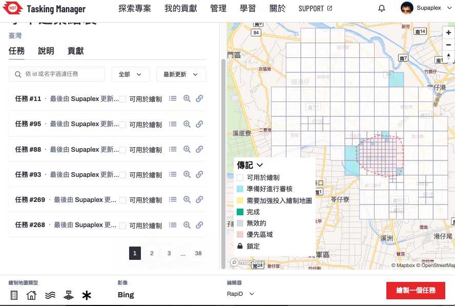
▲ Tasking Manager project page. This project’s main goal is to map Xiejie District, Tainan City.

There are a total of 107 changesets, 29 from our staff, and 3 from community members for the NCKU workshop. The number of participants from NCKU is 22 students with a total of 75 changesets. During the whole workshop, there are 369 buildings mapped.

See full entry

Location: Daxue Village, Eastern District, Tainan, 701, Taiwan

Who did it screenshot at Bajo Sinú área

I want to share my personal use of one tool I’m learning at #UNMappers Validation training guided by SeverinGeo

At Colombia OSM community there was some discussion a while back about best practices for users tracking changes in specific zones.

I know that you are tracking the areas you map. I have been doing that work with a particular area in which we have an organized mapping project, the Bajo Sinu River basin, Cordoba, Colombia.

I have been using a simple script from FeedForAll called rss2html, that helps me to publish RSS feeds in a .php by myself. I use it as source to make Humanitarian and Human Rights simple News dashboards for people not too related to tech stuff, but in need of information, working and living in field.

For example, with Rss2Feed I use a News feed for Arauca region in Colombia, one of the most affected areas by Human Rights violation and breaches of International Humanitarian Law events.

See full entry

Location: Lorica, Bajo Sínú, Córdoba, Colombia

Collaborative Mapping Workshop for Beginners promoted by Umbraosm, UFV and Brazilian Youtmappers

On April 1st we held a mapping workshop for beginners on OpenStreetMap as part of the Mapeia Belém Project initiative, which aims to update data on the limit of the Legal Amazon but also train new mappers to join collaborative mapping!

The federal university of Uberlandia UFU, mappers from the Brazilian Openstreetmap community and members of Youthmappers Brasil took part in this initiative. The workshop link can be seen on our YouTube channel. https://www.youtube.com/watch?v=JqiOr6RPmuU&t=396s

From now on I want to thank everyone who participated in our workshop on behalf of UMBRAOSM - the union of openstreetmap mappers

Location: Boa Vista, Recife, Região Geográfica Imediata do Recife, Região Metropolitana do Recife, Região Geográfica Intermediária do Recife, Pernambuco, Northeast Region, Brazil

Mapping Workshop for Beginners on Openstreetmap

https://www.youtube.com/watch?v=JqiOr6RPmuU

Umbraosm Union of Brazilian Mapeadores do Openstreetmap Offered a workshop for new mappers beginning in openstreetmap in a hybrid way. Members of Umbraosm, Students from the Federal University of Uberlândia UFA and members of Youthmappers Brasil participated in the Workshop.

The video of the new mappers workshop at Openstreetmap is now available on YouTube.

See full entry

Location: Boa Vista, Recife, Região Geográfica Imediata do Recife, Região Metropolitana do Recife, Região Geográfica Intermediária do Recife, Pernambuco, Northeast Region, Brazil