OpenStreetMap logo OpenStreetMap

Diary Entries in English

Recent diary entries

Sometimes I think I’m a bottom feeder going through the map and cleaning up the obvious errors and this comes from my observations over time and cleaning up thousands of duplicate buildings.

Because many countries do not have good census data you can do a rough calculation by multiplying the number of houses by an average number of people who live in them. It isn’t perfect but if you have nothing better then it works.

So duplicate buildings are a problem. When you’re looking to see how many schools you need duplicate buildings mess the numbers up. Buildings incorrectly tagged or not tagged at all also mess the numbers up.

Then we get to the imagery used. These days I’m seeing more and more microsoft BuildingFootprints tags on buildings. They are normally very accurate and align well with Bing imagery. The largest most accurate satellites are only accurate to 60 meters so the imagery has to be aligned. My recommendation would be to use Bing imagery and find a building that aligns with it. Then switch to your preferred imagery and align it with the Bing aligned one.

This helps ensure that buildings are only mapped once and when you add buildings you don’t add an existing building and if someone imports using microsoft BuildingFootprints then your building won’t be remapped 10 meters away in the future.

Disposable mappers are often used meaning many will only may a few times. So we don’t really have time to train them.

We want to get the most accurate mapping we can from them and as many buildings as we can. With JOSM buildings_tool plugin I can highlight one building then add more by clicking and holding down the button, moving to the opposite corner of the building and releasing the mouse button. If they aren’t in line it takes another mouse button click. You get a rectangular building correctly labelled. This is far less than using iD. Plus you don’t need a validator to inspect each one to see if it is correct.

See full entry

Posted by Pisto81 on 30 June 2024 in English.

Well, the fellowship was the first of its kind for me. The whole time, the commitment led me to learn and know the vast features and tools of OpenStreetMap. The fact that overwhelmed me most that how the organization has managed and engaged numerous volunteers and improved its tools over time. Training and resources were efficient and convenient in a structure that proved instrumental for me in completing the tasks. The biggest delight is seeing my edits come into visualization within moments which truly instills a feeling that I am making an impact by mapping. Throughout the whole time, I have been able to discover a little of it and may also have made slight and/or big mistakes during edits or validation, ahead of this, I want to explore this platform more and be an instrumental mapper.

The Importance of Community Mapping

Over the past two decades, in particular, mapping has become open access, since map data is increasingly used to support society facing crisis. As this goal gained momentum, a community-driven mapping interface emerged in 2003. Open Street Maps pioneered the way for easy updating and access to map data at your fingertips.

It was a marvel back then, and these mapping tools paved the way for Crowdsourced Mapping after the catastrophe in Haiti in 2010. However, there is still a large human resource deficit that can only be satisfied if we make OSM knowledge prominent throughout institutions and schools alike, as was cultivated in the OSM Guru Program during in-person training at JNTU, Hyderabad.

See full entry

Location: Ward 114 KPHB Colony, Greater Hyderabad Municipal Corporation West Zone, Hyderabad, Kukatpally mandal, Medchal–Malkajgiri, Telangana, 500085, India
Posted by JoshuaOrais on 30 June 2024 in English.

OM Guru

From a casual interest in maps to fully diving into the depths of community mapping and data validation, that is how I can describe my OpenStreetMap journey up to this point.

Programs conducted by the YouthMappers Network, Humanitarian OpenStreetMap Team, and the Open Mapping Hub Asia Pacific taught me everything I know in the field of open mapping. These programs continuously introduced me to the wonders of the geospatial field, from the creation of maps to real-world applications of open spatial data; and they consistently piqued my interest, driving me to learn even more. When the opportunity came to be one of OMHAP’s Open Mapping Gurus, I was ecstatic. It was a chance to learn from the best and most experienced people in the field and an opportunity to help the community—the core value of being an open mapper.

See full entry

Me, MySelf and OM Guru Fellowship

Hello Fellas! Greetings from Indonesian Mapper.

Okay, I believe this is my first diary entry as I start contributing to OpenStreetMap. I’m not sure how many people will be interested in reading my diary, but I’ll share my story here.

“Above the sky, there is still sky” - it’s a quote we’ve probably heard before. OpenStreetMap is made up of many contributors from around the world, all of whom are great mappers and work diligently for the world. I realize that the knowledge I have now must have been possessed by several people before me. Because of this, I feel that with OpenStreetMap, I can learn and collaborate with other mappers.

Just a quick flashback to 2019 when I made my first contribution to OpenStreetMap. At that time, I was still unsure of what OpenStreetMap was. I thought it was just a mapping tool and had no idea about the many surprises it held.

As a geography student, mapping is my passion, and I enjoy contributing to OpenStreetMap. To my surprise, I became the best mapper in a competition held by OpenStreetMap Indonesia. In 2021, I was the only Indonesian participant in the HOTOSM internship. The following year, I was hired at OpenStreetMap Indonesia (POI), and now I am part of the OM Guru Fellowship program. The Om Guru gives us tasks to work on each month, I am responsible as a validator, where the tasks given to me are things related to validation. I carry out validation using quite a lot of media such as OSMCha or OSM Inspector, of course, this adds to my knowledge and skills.

“For me, by consistently practicing and loving what we do, we will invite miracles into our lives”.

See full entry

Location: RW 03, Petojo Selatan, Gambir, Central Jakarta, Special capital Region of Jakarta, Java, 10160, Indonesia
Posted by roxystar on 29 June 2024 in English.

Munich Trudering shines – München Trudering leuchtet

Fascinated by the conceptual work and the impressive renderings of the “MASTERPLAN BELEUCHTUNGSKONZEPT FREIHAM NORD” <1> I was wondering if one would be able to “re-engineer” the existing reality of a city or a city district by means and capabilities of Open Street Map in order to finally achieve a rendering similar to <2>.

First steps

OK, I thought, let me try to find out. I started to walk through the streets of my neighbourhood identifying and positioning street lamps with the tool EVERY DOOR. As always the devil is hidden in the detail. How to determine height? Typically in the early evenings (I order to see the laser dot), I started to measure the distance from street level to lamp body with an of the shelf laser instrument (BOSCH Zamo 3). This worked quite well in not so busy streets however I did not had the guts so far to do a measurement in one of the main streets with constant traffic especially when the lamp poles are located at the center of a 4 lane street. I need to find an alternative solution for those cases. Height is one of the most important parameters for illumination.

I was made aware by a very helpful OSM member <3> that there is a moving map renderer <4> to display exactly the kind of rendering I was looking for. It turned out that this tool is becoming my most important tool for quality control. Gaps and irregularities in “lighting” and referencing are very easy to identify.

“Picture 1”: Current progress for Munich Trudering.

Next steps

See full entry

Just getting started with OSM tonight. Ive been a lover of maps and geography since as far back as I can remember. My interest in globes and maps lead me to travel to many places and put experiences with long standing “points on paper”. What has brought me to learn about openstreetmaps is an interest (an obsession rather) in helping to connect a growing global community of freedom fighters who believe money should not be controlled by an oligarchy, but remain open source.

For all the merchants who see the infrastructure of money as public domain and recognize how imperative it is to ensure everyone has access to permissionless, uncensorable transactions, I solute you and will be working on helping the growing but still niche community know where they can shop with other like minded people.

There are several mapping organizations on this same beat, and I believe the decentralization and variety of options to map these merchant datapoints, highlighting and emphasizing certain relevant offerings within the broader community will be net beneficial to all, as well as keep standards competitive and delivery of info evolving.

Looking forward to to using this platform!

Location: Cabo Norte Merida, Temozón Norte, Mérida, Yucatán, Mexico
Posted by TilokChetri on 28 June 2024 in English. Last updated on 14 July 2024.

Hello Friends, I am Tilok I am from Assam, India. I would like to share my OM Guru fellowship experience.

For the past five months, I’ve been on an incredible journey as an OM Guru, Asia Pacific Hub Mapping Fellow. It involved exploring the digital landscapes of Micronesia, Vanuatu, Philippines, Tonga, India, Pakistan and many more through different humanatarian projects.

My mission? To map these regions using IDEditor and JOSM. I felt like a digital explorer, uncovering and mapping unmapped roads, buildings, and landmarks.

Enter Everydoor, a game-changer for adding Points of Interest (POIs). This mobile app turned POI hunting into a real-life treasure hunt! I must’ve added over 100 POIs around my own neighborhood, making the map a more accurate reflection of the cool places around me.

But the real thrill came with Mapillary. This app lets us collect POIs on the go! Imagine cruising down the highways and streets, phone mounted on the dashboard, capturing street views that were previously missing. It’s like creating a digital time capsule of the places I visit. Back home on Wi-Fi, I’d use Rapid Editor to review the photos and add those missing POIs. It’s incredibly satisfying to see those blank stretches on the map suddenly come alive with street view data!

And let’s not forget validation – the quality check of the mapping world. Coming into the fellowship, I had dabbled in validation, but these past months filled me with confidence. Now, I can ensure the accuracy of other mappers’ work, making the entire map even more reliable.

Speaking of making a difference, checking out https://yosmhm.neis-one.org/ and seeing my “mapping footprints” is truly inspiring. It’s a visual representation of my contribution to this massive, collaborative project.

See full entry

Posted by jothishbabu on 28 June 2024 in English.

Today, I want to look back on my time with OpenStreetMap (OSM) and how the OSM Guru Fellowship has helped me grow.

I started contributing to OSM in 2019. Since then, I’ve made over 2000 changesets. Each one has helped make the map a bit better and more accurate.

Working with Jungle Bus and GeoMinds has been great. These projects showed me how important good maps are, especially in places that need them most. I’m proud to have been a part of their work.

One of my biggest projects was mapping public transportation in Kochi. We added 24,000 kilometers of routes to OSM. It was a huge task, but knowing it helps people get around the city makes it all worth it.

The OSM Guru Fellowship has been amazing. It taught me a lot about OSM and its concepts, giving me the skills I needed to be a better mapper. I learned that knowledge is power, but community is even more powerful.

The OSM community is something I love being part of. It’s inspiring to see people from all over the world work together to map the world. The fellowship connected me with others who are just as passionate about mapping as I am.

Looking back, I’m thankful for everything I’ve learned and the people I’ve met. The OSM Guru Fellowship has been a big part of my journey, and I’m excited for what comes next. Here’s to more mapping and a stronger community!

Posted by jothishbabu on 27 June 2024 in English.

Kinnakorai is a beautiful village about 50 km from Ooty town. The beauty lies in the journey to the village itself. Kinnakorai is similar to any other remote mountain village in India, but the villagers looked at us like we came from Krypton on a UFO. I can’t blame them at all because we were in full gear with 25 people on different motorcycles.

By the way, the day I realized that the road to the village was incorrect, I had the complete GPX trace along the route. So, I planned to fix the roads, and here we are. I edited the roads with my GPX traces and pushed the updates to OSM. Now anyone can rely on those maps. :)

Posted by TrickyFoxy on 25 June 2024 in English. Last updated on 9 July 2024.

In new version of userscript, I focused on analyzing edits. QuickLook for changesets, hotkeys, filtering changesets, mass actions and more.

I wonder how well this phenomenon is known in the world 🤔

Help wanted: I would be grateful if someone knows how to get into the site code and manage the map (add new objects, change layers, colors …) This would make it much easier for new features to appear. Otherwise, they will only be available in OSM-NG (: upd: solution found!

👮‍♂️ QuickLook of changes in tags

Now you don’t need to open OSMCha for simple changesets. Tag changes will be visible directly on the changeset page.

See full entry

I started my journey as an OSM contributor in August 2018. My knowledge was initially limited to the iD editor and HOT tasking manager platform, with minimal community mapathon contributions within Nigeria. Consequently, my contributions to OSM were very low and inconsistent.

In November 2023, while seeking more opportunities to volunteer and contribute to the growing OpenStreetMap community, I discovered the OM Guru fellowship organized by the Open Mapping Hub Asia-Pacific. I applied as a Mapper, which complemented my background as a Remote Sensing and GIS student.

During my six-month tenure in the fellowship, I was exposed to various aspects of mapping, from building data capturing using JOSM, to Amenities/POI mapping with Every Door, and street-level imagery capturing using Mapillary, focusing on Disaster, Humanitarian, and Climate action. Additionally, I learned and developed my skills in JOSM validation and field mapping. The weekly training sessions and webinars exposed me to more applications of GIS and Remote Sensing in open spatial data science, thus enhancing my geospatial expertise.

One significant highlight of the fellowship was the Climate Change Challenge, where OM Guru-led groups competed in 8 climate challenges. I led a team of OSM contributors, which provided me with valuable leadership and teamwork experience. I was exposed to more applications and tools within the OSM ecosystem, such as Mapswipe, Maproullete, and mapping with RapidID. I contributed to mapping high priority, disaster prone and impacted areas in Asia-pacific countries.

See full entry

Location: Katabon, Shahbag, Dhaka, Dhaka Metropolitan, Dhaka District, Dhaka Division, 1205, Bangladesh
Posted by IrdiIs on 25 June 2024 in English.

Travelling to Thessaloniki today and got a 10-hour bumpy bus drive ahead.

Mapping while travelling by bus is definitely a huge challenge, but I think I managed to map Hajdaraj.

I think the village includes another area close to it, but somehow it is separated in a different residential area. Ill double check to make sure I got it all.

“#100villagesin100days #day21”

Welcome to the twelfth OpenStreetMap NextGen development diary.

This week brought some exciting updates and major news!

🔖 You can read my other development diaries here:
osm.org/user/NorthCrab/diary/

⭐ This project is open-source and publicly available:
https://github.com/Zaczero/openstreetmap-ng

🛈 This initiative is not affiliated with the OpenStreetMap Foundation.

In case you missed it…

We are now welcoming new contributors! To show our appreciation, we offer contributor incentives. If you’re familiar with Python, join us – it’s easy to get started!

Continue reading

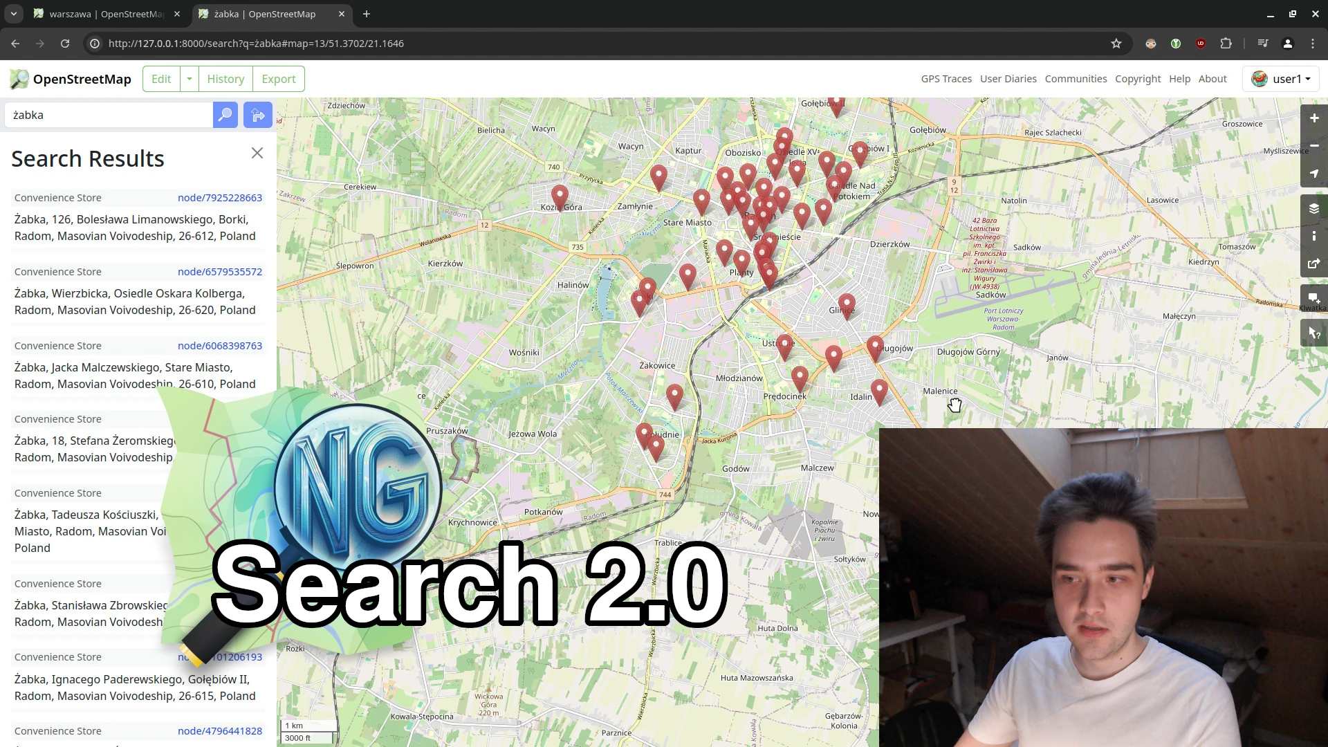
Search 2.0 (with video showcase) 🎉

This week, we made significant strides towards our NextGen vision. The new search functionality is nearly complete, and I’ve recorded a short video comparing OSM Ruby and OSM-NG side-by-side.

⬇ Click below to play ⬇

Video thumbnail

or click here: https://peertube.monicz.dev/w/c7Qwif6S4MpvuBBDu7x8LM

See full entry

Posted by jpennycook on 24 June 2024 in English. Last updated on 25 June 2024.

At the moment I’m only doing small edits, or edits using StreetComplete. I got frustrated by some people making bad edits which persuaded me there were other things that I could do rather than editing OSM.

Particularly annoying behaviours for me:-

  • Dunning-Kruger edits by people who have been here for a while but don’t edit that often - people who are absolutely sure they are right even when queried (and think the wiki is wrong), especially people whose changeset edits read like they are selling houses
  • people deliberately setting data they know is wrong but to make some route planner or map do what they want, even though they have been challenged on this repeatedly in the past
  • people adding data like access, surface, or tracktype in bulk to tracks that lack them just to fill in missing data without any evidence (so all tracks in a particular area get set to tracktype=grade2 whether they are actually asphalt or mud)
  • people copying from developers plans, rights of way descriptions, or other maps at the expense of reality (I map what’s there on the ground, they “correct” it because they’ve seen it on a plan, my journey planner tries to send me on unbuilt paths, through fences where I don’t have access, or my road bike on a dirt track suitable for a 4x4 off-road vehicle, and repeat over several years).

My main goal with editing OSM is to improve route planning on foot, bicycle, or public transport, hence why I’m keen to get surface, tracktype, smoothness, access, and construction tags correct.