Jokes going to be on you now.
Diary Entries in English
Recent diary entries

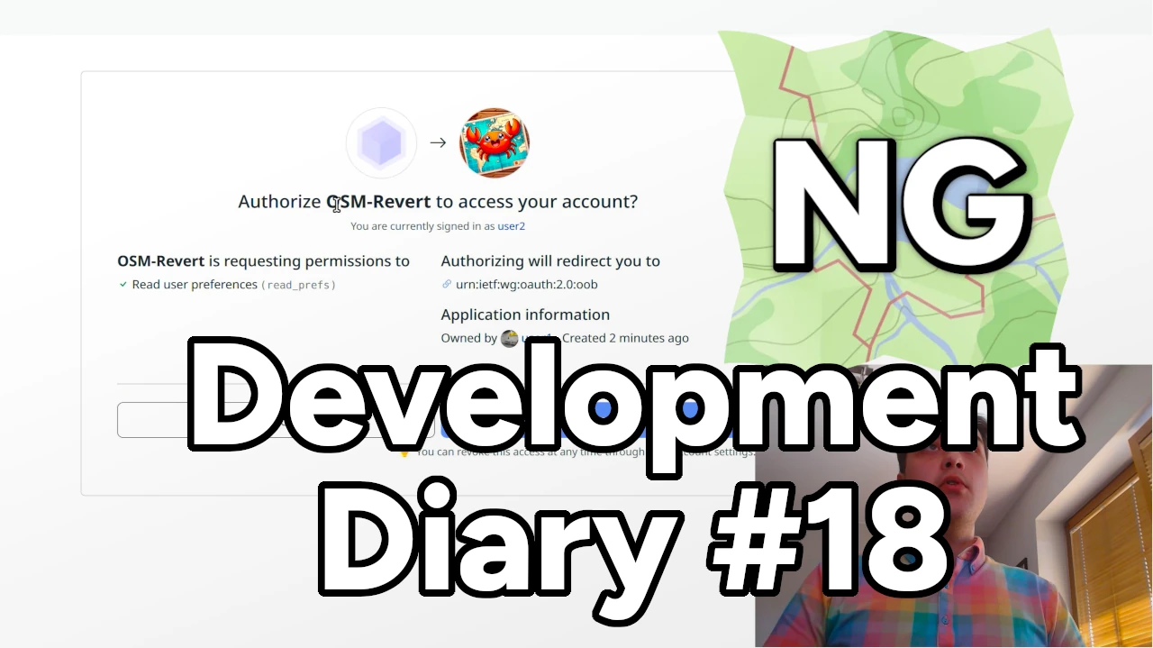
Welcome to the latest OpenStreetMap-NG development update! Since last time, we’ve made significant progress towards reaching feature parity and have also implemented some great, exclusive new features. There’s also an updated roadmap with more detailed public release progress.
🔖 You can read other development diaries here:
osm.org/user/NorthCrab/diary/
⭐ This project is open-source — join us today:
https://github.com/openstreetmap-ng/openstreetmap-ng
🛈 This initiative is not affiliated with the OpenStreetMap Foundation.
📹 Video Summary
I’ve prepared a video summary, where I recap the recent progress and show it off directly on the development website. It’s an alternative and richer version of this diary post. The recording contains chapter information if you’re interested in just some parts of this diary. There’s also a video-exclusive feature highlight :-)
⬇ Click below to play ⬇
or click here: https://peertube.monicz.dev/w/qWPQ8tNQK5VrGENPvpqnR1
OAuth2 Reimagined
Posted by TheFighter137 on 17 October 2024 in English.
Last updated on 18 October 2024.
Here is my first diary entry. A few days ago, I gave myself the following challenge : every day, I will map one city in my department (Seine-Maritime, 76, France), going to the next letter in the alphabet for the next day, and so on. I will mainly map adresses (thanks to the Pifomap tool) ; precise roads’ paths and buildings’ positions ; and create driveways. There are 709 cities in total to map, but some will be easier to map than others for sure. The previous cities were Allouville-Bellefosse, Bacqueville-en-Caux and Cailleville.
Today, I worked on Dampierre-en-Bray. This rural municipality apparently is a relay for cyclists. There is the regional n°527 bus line operated by NOMAD Cars that passes nearby. Lots of single-family homes, as usual in my countryside.
Links to today’s changesets :

Once again i have the pleasure to announce that we, the OpenStreetMap Carto maintainers, have prepared a new release of the OpenStreetMap Carto stylesheet (the default stylesheet on the OSM website). Once changes are deployed on openstreetmap.org it will take a couple of days before all tiles show the new rendering.
Here are some details on the visible changes this release brings to the style.
Adding rendering of shop=hearing_aids with a dedicated symbol
shop=hearing_aids is now rendered with a dedicated symbol rather than just a generic dot. The tag has shown a steady increase in use over the years and is used consistently in many parts of the world now with a total of nearly 10k uses.

https://github.com/gravitystorm/openstreetmap-carto/pull/4909
Thanks to contributor sommerbe for implementing this and working on a suitable symbol.
Restoring rendering of name labels for natural=reef
I came across an article with a map in our local newspaper yesterday via a Facebook post, and at once, I thought “Oh, this map looks very much based on OSM”. This map had been published by the local County Council and had no attribution (to any map provider). So before sending a strongly worded email (because it’s not the first time they used OSM data without attribution), I played a game of spot the difference comparing the published map with OSM and the Táilte Éireann (government agency) data.
Here are just four things I found:

Their map data is from before July 8th 2023 which is when I changed the name of a road according to new signage, but they still have the old name on their map.
I think it’s very interesting that the local government continues to choose OSM over the government provided data (not sure whether it’s a financial issue or a data quality issue), but it would be very decent of them if they attributed correctly.
There doesn’t appear to be a resource available to aid in mapping The Mississippi Schools for the Deaf and the Blind, making it that much more important to map.
- https://msdbk12.org/ - the school’s website
This diary entry serves mainly to help center my mapping efforts to the most important uses I can.
One of my current focuses is the University of Mississippi Medical Center. To my surprise, much of the campus was not mapped - specifically buildings and parking garages. I get it - it looks a daunting task and it is.
Resource
Thankfully the University shares a campus map which has helped greatly. I’m still in the process of mapping the buildings, roads, footways, grass, trees, and flower beds.
Purpose
Obviously mapping a medical campus aids those who need to navigate their way around the various buildings and facilities in an easy and efficient manner. Hopefully this allows those that come after me to:
- Build on this information, contributing more than I can.
- Add ways to utilize this data for helping others (apps, guides, maps, etc.).

You know what can really mess up carefully laid plans? What can even lead to a dangerous situation? When you get to the crossing of the South Fork Trinity River Trail and the East Fork South Fork Trinity River, a waterway that very much is still a river, and that bridge that someone has assured you they know is there is not there. There’s not even the evidence of once having footings for a bridge.
Apparently the mapper knew based on Bing aerial photography. Through thick trees. I can make guesses about how that crossing goes, too. At least when I guess wrong, I know it was a guess and might have made contingency plans around it.
Fortunately in the early days of Autumn, that ford I was LIED to about is just 4m of knee high wading without much current. That river comes out of some mountains that collect snow. It isn’t always so low.
The thing is, if it is important, it HAS to be correct. Your guess isn’t good enough. If it isn’t important, it can be left until someone who knows feels like doing it. There’s no renderer having trouble deciding how to render this crossing. It’s quite common that they aren’t specified.
I’ve been coming across a lot of guesses lately. I know they are guesses because they are wrong.
I was looking over an area I’d been working on when something started feeling wrong. It took me a couple minutes to notice that one of the roads I had aligned recently had sprouted four bridges. What? It was the unimportant spur of an unimportant low standard Forest Service road. They also get referred to as “unimproved” roads. We’re talking a road that might be produced simply by running a blade across the dirt. The whole thing probably cost a fraction of the cost of a bridge and suddenly it had four. Based on Bing imagery again, in which you can clearly see it is just a dirt road.
Hello OSM Community,
I’m currently working on a project to capture 360° images of the city of Salzburg for Mapillary, and possibly for Panoramax later. My goal is to enhance OSM data in Salzburg, especially in areas with notes that could be resolved with better visual context—something 360° images can provide.
Getting the Camera
I reached out to the OSM Belgium team to ask if I could borrow one of their 360° cameras. To my surprise, they informed me that there was already a GoPro MAX 360 in Austria! After checking with the local OSM chat, it turned out that mcliquid had the camera and kindly offered to send it to me.
Route Planning Challenges
Before starting the project, I wanted to plan an efficient route to cover as many streets as possible without overlapping - essentially the Chinese Postman Problem. Unfortunately, I couldn’t find a tool for this problem.
Initially, I tried bikerouter.de to created a GPX route. After importing it into OSMAnd, I found that it wasn’t working as expected - it tried to auto-route between the points instead of following the plan I made. This wasn’t practical for me for capturing 360° images.
The Solution I’m Using Currently
I eventually opted to use OSMAnd’s built-in recording feature. By activating the setting, I could record my route in real-time and have the GPX displayed directly on the map. This way, while cycling, I could instantly see where I had already been and decide on the fly which streets to cover next. This flexibility worked much better for capturing pictures around Salzburg.
Managing the Photos for Upload
From past experience, I knew that the Mapillary uploader struggles when handling too many files at once, leading to issues that require a full reset of the uploading-tool.
To avoid this, I used PowerShell to split the images into folders of 250 files each, which made the upload much smoother and basically error-free. This small step ensured that I could process and upload my imagery without hiccups.

I recently finished this mini-project where I implemented the classic 15 puzzle game but using the standard OpenStreetMap tiles as the sliding pieces!
While there are many implementations of this game online and in app stores (some even let you upload your own image), as far as I know, not one directly uses OSM slippy map tiles for the pieces. I figured this would be a nifty side coding project and it was fun to do!
Currently you can play any of 20 map locations. Enjoy! 🎉
Play the game here: https://seav.github.io/osm-15-puzzle/
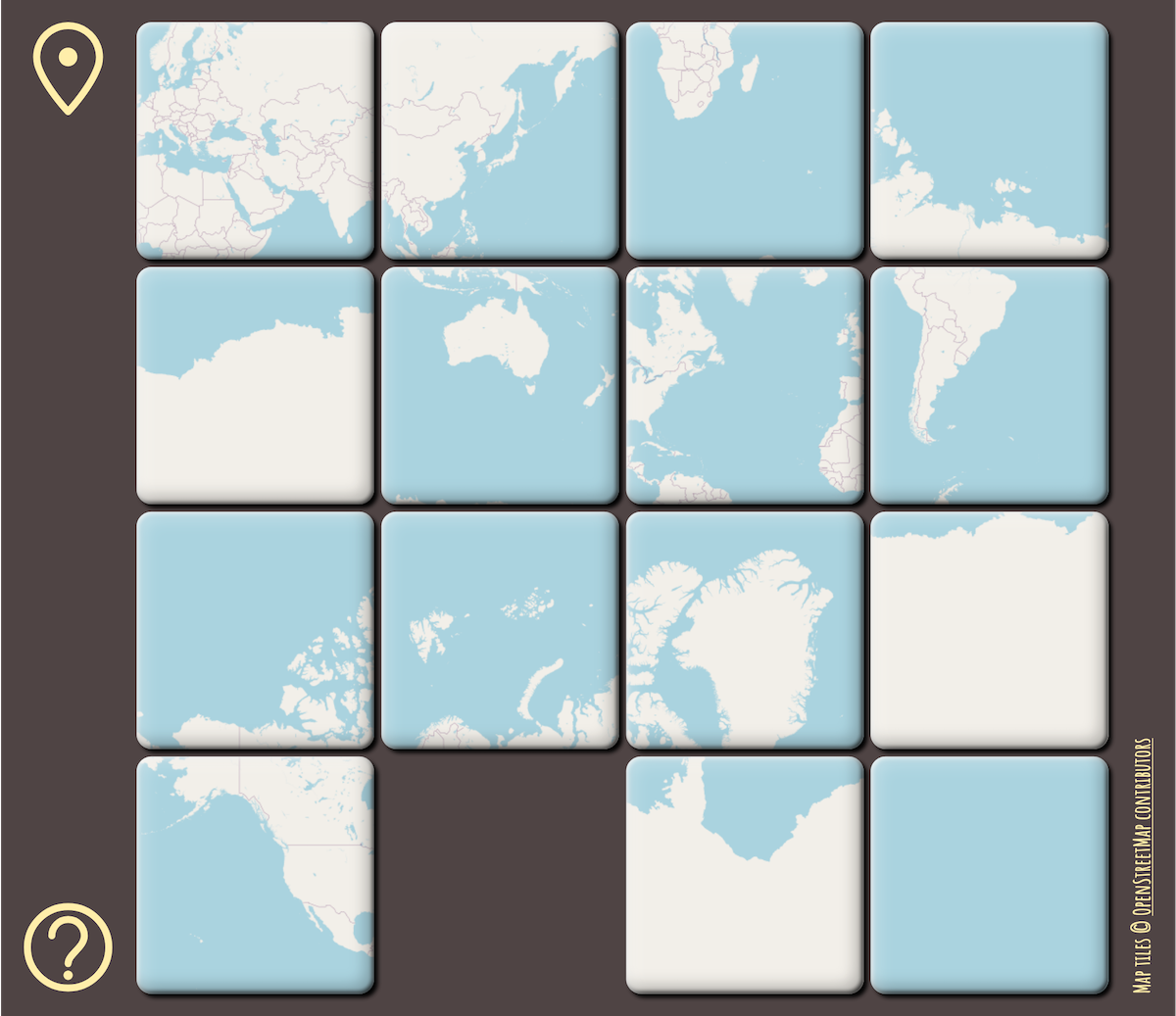 Scrambled puzzle showing the whole world in Mercator projection
Posted by Crystal Hargens _ on 11 October 2024 in English.
to unauthoized user is my maps leave it alone get your own account use your own apple maps never use me ever
Posted by Kingsley AMANKWE on 11 October 2024 in English.
Last updated on 20 October 2024.

It’s that time of the year again, and once more, I find myself sharing my experience from State of the Map Nigeria 2024. Unlike last year, when we didn’t have workshops, this time we were spoiled with multiple workshops, covering various topics that kept participants actively engaged. Plus, for those who missed any sessions, we now have everything recorded and uploaded to our YouTube channel to revisit at any time!
Unfortunately, as the Programs Lead, I missed many of the live sessions myself. But during the few times I could sneak into a session, I was blown away by the depth and engagement. This conference had that special vibe, the kind that makes you wish it lasted longer. I’m confident that everyone who joined will be excited to return next year.
One of the things that stood out this year was the diversity in our participants. We had people coming from across the north, south, east of Nigeria, and even Ghana! Meeting new faces, like my new friend Calvin Menttor from Ghana, was an absolute pleasure. By the way, I finally got to see the Ghana cedi in person 😄.
To my Tech Crew, Joshua, and Justice, I must confess that I still mix your names up sometimes 😅, but it was a fantastic experience working with you both! Together, we made the media coordination a breeze (though, Justice, you did leave me to freeze by taking the duvet 😂).
Shout-out to my Logistics HoD, Olurunkosebi, and Welfare HoD, Titi. You both made my job so much easier! You ensured that meals arrived on time and that all the participants had a comfortable experience.
And I can’t forget Hajar from TomTom, who supported us with the mapping project used during the conference. Your contributions were invaluable, and we’re incredibly grateful.
Posted by mahjabin08 on 10 October 2024 in English.

Heatwaves have become a growing concern in recent years, and this year they’ve hit Bangladesh harder than ever, posing serious health risks. Our team, Three Dot, is competing in the Forewarn Disaster Hackathon 2.0, where we’re developing an app to provide heatwave alerts and an AI assistant that offers crucial advice on heat-related health issues.
One of the key features of our solution is providing users with the location of the nearest cooling centers—places with public accessibility, where people can cool down safely. These could be shopping malls, super shops, or mosques—any space that’s well-ventilated and free for the public to stay in.
The challenge we faced is that such attributes don’t exist in OpenStreetMap (OSM) for Bangladesh. Drawing on my previous experience as the former president of YouthMappers at Eastern University, I took the initiative to map out potential cooling centers. We’re tagging these places with: 1) Cooling_center: yes and 2) Cooling_center_bd: yes, to create a reliable resource for users and develop our heatwave project on top of that. Initially, our target location is, Dhanmondi and Mohammadpur.
Our initial focus has been on mapping spaces open to the community, such as large shopping malls and mosques, so that people can find refuge during extreme heatwaves, even if just for a short time.
Posted by Justinebaekc on 9 October 2024 in English.
When I finished high school, I joined the Rwanda Red Cross because I have always loved humanitarian work and felt a strong duty to help people in any way I could. Becoming a trainer with Rwanda Red Cross gave me a sense of purpose in humanitarian action. I first encountered Humanitarian OpenStreetMap (OSM) during a disaster response for landslides and flooding in Rwanda, where many lives were lost. As a volunteer with the Rwanda Red Cross, I was part of the response team. After witnessing the destruction of buildings and roads by the floods, I began to wonder how people could be helped to avoid living in areas prone to such disasters. I thought about the potential of maps to identify unsafe places but didn’t know how it could be done.
One day, a friend introduced me to OSM Rwanda after I expressed my curiosity about maps. I joined the community, and on my very first day, I was trained on the importance of mapping for humanitarian response. I learned how to map roads and buildings, and though it wasn’t easy at first, I was deeply motivated. My curiosity had found a solution, and I was determined to continue contributing to mapping.
I started attending more mapping sessions and OSM events, learning and growing my skills. Eventually, I became a trainer in OSM Rwanda, teaching newcomers about mapping. This role allowed me to learn even more, as teaching others exposed me to different aspects of mapping. Over time, I made significant contributions and applied for a scholarship to attend the State of the Map (SOTM) conference in Nairobi. I believed it would be a great opportunity to expand my knowledge, and I was thrilled when my application was accepted.
🖤
This project is created to map POIs and landmarks using field-collected Mapillary but I couldn’t find this filter.
Learning as I go…

I started mapping a few weeks ago, sticking (mostly) to North Muirton in Perth for now as I have lived here for 50 years so I think I know it quite well. No doubt I’ll have done a few things wrong along the way but I’ll go back and fix, if and when I realise. As I write this, almost all the houses and flats in NM are at least drawn out with a few streets still to be tagged with the “basics”.
I intend to add (or finish)
- Electricity Substations (all operated by SSE? - I think they all are)
- Grit Bins
- Public Benches
- Garages (rented out by the local council)
- Add all postcodes
- Public pathways (miles of them!)
- Back fences (the 6ft high ones around all the back gardens)
- Grassy areas
- Road crossings
- Drying greens for the 8 and 4-block flats
Posted by PRISCOVIA12 on 5 October 2024 in English.
 This Conference was a Good opportunity for me and all the team from Rwanda as well as Africa in General because it was the first time of Africa to host the state of the Map.
apart from traveling from Kigali to Nairobi for 26hours in the bus ,I enjoyed every details in the conference and Nairobi.
This Conference was a Good opportunity for me and all the team from Rwanda as well as Africa in General because it was the first time of Africa to host the state of the Map.
apart from traveling from Kigali to Nairobi for 26hours in the bus ,I enjoyed every details in the conference and Nairobi.