OpenStreetMap logo OpenStreetMap

Diary Entries in English

Recent diary entries

Cox’s Bazar, the breathtaking coastal city of Bangladesh, recently hosted the State of the Map Asia 2024 conference. For me, as an enthusiastic mapper, participating in this event was nothing short of a dream come true.

From the moment I entered the venue, I could feel the vibrant energy of the OSM community. The conference brought together passionate mappers, developers, and humanitarian workers, all united by their dedication to open geospatial data. The diversity among attendees—ranging from seasoned experts to curious newcomers—was a testament to how OSM truly belongs to everyone.

The talks, presentations, and workshops stood out as the heart of the event. Participants shared innovative ideas and showcased how OSM is addressing a wide array of societal challenges. These stories of success, coupled with best practices from various communities, highlighted the platform’s versatility and its potential for driving meaningful change.

Equally inspiring were the contributions of the sponsors, who not only supported the conference but also offered valuable insights into how OSM is applied in diverse industries. Their perspectives reinforced the idea that OSM is not just for mappers—it’s a tool for anyone aiming to understand and improve the world.

One of the most rewarding aspects of the conference was connecting with people from across Asia. Despite being an introvert, the friendly and inclusive atmosphere encouraged me to step out of my comfort zone and embrace the sense of community. Every conversation, whether formal or casual, enriched my understanding and reinforced that OSM is as much about collaboration as it is about mapping.

A highlight of the event was the Open Mapping Guru Dinner, an evening filled with meaningful interactions, shared experiences, and celebrations of the collaborative OSM spirit. It was a perfect reminder of how strong and inspiring the global OSM community truly is.

See full entry

Posted by Rabina Poudyal on 14 December 2024 in English. Last updated on 17 December 2024.

Charting New Paths: Insights from SotM Asia 2024

This year, I had the opportunity to attend State of the Map Asia (SotM Asia 2024) in Cox’s Bazar, Bangladesh. While I had previously attended the SotM Global conference, SotM Asia provided a unique and inspiring experience that deepened my engagement with the OpenStreetMap (OSM) community. The conference brought together passionate mappers from all over, each contributing their expertise to solve real-world problems using geospatial data.

As a speaker at SotM Asia, I shared insights on how OSM is being used to improve accessibility to essential services, particularly for women in marginalized communities. The conversations that followed were both thought-provoking and affirming, showing how mapping can be a powerful tool for addressing gender-specific issues.

The workshops and sessions at the conference were incredibly valuable. I gained new perspectives on how emerging technologies are transforming mapping and how they can be applied to address complex challenges. These experiences inspired me to think creatively about the tools and methods I can incorporate into my own work, particularly in my ongoing projects.

Beyond the sessions and workshops, the conference was an opportunity to connect with like-minded individuals. From casual conversations over coffee to the camaraderie at the OM GURU dinner, I was reminded of the importance of community in the open mapping movement. The connections made here will continue to inspire and motivate me as I work on future mapping projects.

Reflecting on SotM Asia 2024, I am deeply inspired to continue my work in the OSM community and beyond. The event reaffirmed the transformative potential of mapping and reinforced my belief in its power to create a more connected, resilient world. I look forward to carrying these lessons into my ongoing work, including the WASH initiative in Birendranagar.

Acknowledgments

See full entry

Location: Budol, Banepa-06, Banepa, Kavrepalanchok, Bagamati Province, 45210, Nepal

This year, I had the incredible opportunity to attend State of the Map (SotM) 2024, the global conference of the OpenStreetMap (OSM) community, held in the vibrant city of Nairobi, Kenya. As one of the travel grant winners, generously supported by the OpenStreetMap Foundation, this experience marked a significant milestone in my mapping journey. It was my first time at SotM, and I was beyond excited to connect with mappers, developers, and enthusiasts from across the world.

The highlight of my participation was co-presenting the topic “OSM: Spectrum” alongside my fellow mapper Pragya Pant. Together, we shared insights into the diversity of mapping practices in Nepal and the importance of inclusivity within the OSM ecosystem. It was truly empowering to showcase our work on a global platform and engage in meaningful conversations with the audience. The support and enthusiasm we received were incredibly motivating and reinforced the value of collaboration within the mapping community.

One of the most memorable aspects of the conference was meeting so many individuals I had previously interacted with online. Seeing these familiar faces in person was both surreal and heartwarming. The conference served as a bridge, turning virtual connections into tangible friendships. I had the chance to meet mentors and inspirations such as Arnalie and Benedicta whose dedication to OSM has been a source of motivation for me since I started mapping. Their passion and leadership continue to inspire me to push boundaries and contribute meaningfully to the community.

I am also immensely grateful to Mikko, whose consistent support has been instrumental in my mapping journey. Mikko brought together the OSM gurus from Asia before the conference, helping us prepare and connect even before reaching Nairobi. His efforts made a significant difference, and his encouragement continues to inspire me.

See full entry

Location: Tansen--02, Tansen, Palpa, Lumbini Province, Nepal

Mapping My Way to Inspiration: Reflections from SotM Asia 2024

This year, I had the privilege of stepping into a world of boundless ideas and shared dreams as I attended the State of the Map Asia (SotM Asia 2024) in Bangladesh. It was my first time at this prestigious conference, and the experience was more transformative than what I had thought. From the moment I arrived, I could sense the synergy of brilliant minds united by their passion for open mapping and the power of geospatial knowledge. The conference was a melting pot of diverse contributors—youthful innovators with fresh ideas and seasoned leaders whose enduring dedication has shaped the open mapping movement. It was heartening to see how this collective energy is driving solutions for challenges like disaster management and sustainable development. Conversations with participants revealed the exciting role startups are playing, leveraging OpenStreetMap (OSM) data to revolutionize industries and create meaningful societal impact.

As I stood there representing the YouthMappers community, I couldn’t help but feel a swell of pride. My tenure as Vice President of the YouthMappers chapter in 2022-23 had been a defining period, filled with opportunities to lead projects that empowered communities and fostered collaboration on a global scale. Now, as an alumnus, I was honored to showcase the results of our collective efforts. It was a reminder of the transformative power of teamwork and the potential of mapping to change lives.

See full entry

** Disclaimer: I do not guarantee the accuracy of these names **

I decided to compile some OSM objects named like celebrities for fun (with up to two examples each). This time let’s focus on music artists (sorted by date of birth).

Elvis Presley (1935-1977)
* Montevideo, Uruguay
* Sint-Genesius-Rode, Belgium

John Lennon (1940-1980)
* London, UK

Freddie Mercury (1946-1991)
* Montreux, France

Madonna (1958-)
* Baltimore, US-MD
* Ardspach, Czech Republic

Michael Jackson (1958-2009)
* Shekvetili, Georgia

Céline Dion (1968-)
* Laval, Canada

Jennifer Lopez (1969-)
* San Rafael, Costa Rica

Jay-Z (1969-)
* Harwich, US-MA

Eminem (1972-)
* Orléans, France

50 Cent (1975-)
* Ernakulam, India
* Pomigliano d’Arco, Italy

Shakira (1977-)
* Saas-Fee, Switzerland

Alicia Keys (1981-)
* Saint-Jean-d’Heurs, France

Beyoncé (1981-)
* London, UK

Britney Spears (1981-)
* Eagle Mountain, US-UT
* Edinburgh, UK

Lady Gaga (1986-)
* Sacramento, US-CA
* Davao City, Philippines

Rihanna (1988-)
* Cotonou, Benin
* Trondheim, Norway

Ed Sheeran (1991-)
* Kuala Lumpur, Malaysia

Location: Owo, Ondo State, Nigeria
Posted by b-unicycling on 11 December 2024 in English. Last updated on 1 January 2025.

So, about 6 weeks ago, I met someone who teaches at Simpson College in Indianola, Iowa at a conference here in Ireland. This made me curious about Indianola, and I went to check it out on OSM. Anything could trigger that in me.

I found the campus fairly well mapped with most of the buildings and most of the highway=sidewalk and some trees mapped, but there was more to be done. So, I started off easy with some footpaths, trees and missing buildings, but then I got competitive and wanted to see how long it would take be to get into the list of mappers for the US of A in the OSM stats.

That took me much longer than expected, because I’m used to get onto those lists fairly easy having mapped in much smaller countries with far fewer active mappers. But after about two weeks (I don’t remember exactly), I was in the Top 500. Yee-haw!

As of this morning, I was #160 which is not so bad, considering I “had to” hold my #1 in Ireland and stay in the Top 20 in the UK.

See full entry

Location: Indianola, Warren County, Iowa, 50125, United States
Posted by DeBigC on 10 December 2024 in English. Last updated on 11 December 2024.

Here I go again…. part 2.

I was pleased to see someone pick up on my first diary item. OSM weekly is hardly the New York Times, yet I know that the editors like posts which are constructively critical, and they did spot that I was hoping for something to happen which would let us all “do better”.

I decided to look in more detail at how the lack of detail was leaving validators with a lot of mapping to do. Evidence of this is seen here, where the mapper marking the tile as “completely mapped” is nowhere near being the main contributor of objects and the validator – DeBigC – has add or adjust 62% of the objects in the tile. This shows the last mapper to touch any object. Screenshot-2024-12-11-112534 Note: I do accept that this is one tile, but it’s not unusual to find this all over the Fingal task.

See full entry

As a friend and I were adding the 57th tag to a climbing gym in Belgium, I wondered what the element with the highest tag count is. I couldn’t find such stats (which may be a good thing), so I downloaded belgium-latest.osm.pbf from Geofabrik and wrote a simple Python script that uses Pyosmium to do some counting for me.

Without further ado: the Belgian record for highest tag count is… the relation for Belgium itself actually, which currently has 491 tags. The non-relation with the highest tag count is, boringly, the node for Belgium, with 288 tags. Next up are Brussels (156 tags), the Council of the European Union (79 tags), one particular section of the River Meuse that somehow got its name mapped in 57 different languages (65 tags) and the Irish embassy (also 65 tags). Next up is the first element that has a lot of tags not because it’s just flooded with languages! This maritime beacon north of Antwerp in the River Scheldt has a respectable 63 tags to describe all its lights. Our climbing gym is not far off from this one, and has a lot more diverse information in its tags I’d say.

I noticed that the relation for Belgium also has a high version number, it’s at its 1043th revision. That prompted me to take a look at version numbers too. But 1043 isn’t even close to our record, which goes to the superroute relation for the E40 (version 3141). Granted, that’s international. The version record for a purely Belgian object is the hiking route GR 126 (version 1103) from Brussels to Membre-sur-Semois. Just like with tag counts, I find it more interesting to look at non-relations here, though. There the honour for highest version goes to one of the outer rings of a farmland multipolygon south of Mons, which is at version 277. Funnily enough, in contrast with its senior version number, it almost has no tags to speak of, only a source!

See full entry

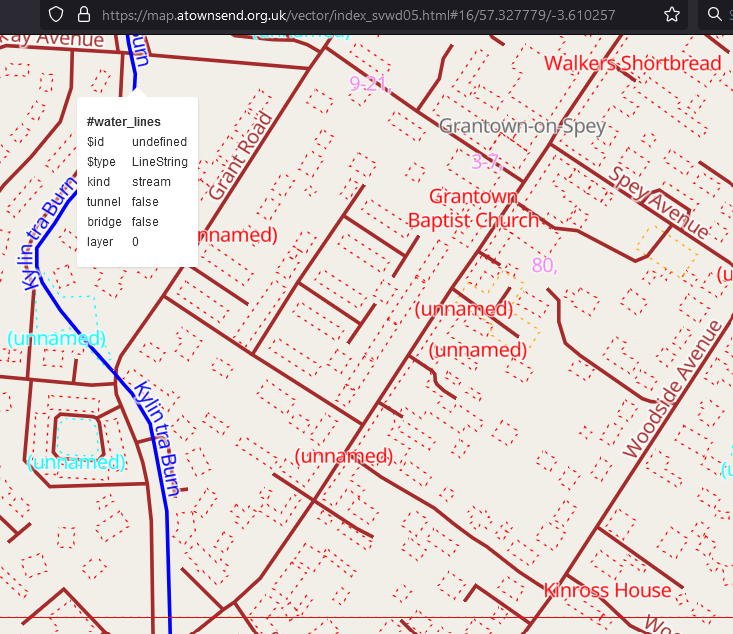
Screenshot of the svwd05 map style, showing a Walkers Shortbread shop in Scotland

I created this for my own use, but am sharing it here because it might be useful to other people too. This is the style and there’s a brief readme.

It uses different colours to highlight different map layers. It’s not supposed to look nice; just to show you what is there.

I believe that everything described in the schema is included. If a feature does not appear it might be because:

  • it’s not in the Shortbread schema.
  • it’s in the schema, but is for some reason missing from the OSMF vector tiles.
  • it’s in the tiles, but there’s a bug in this style.

There are lots of features in the first category, and there seem to be a couple in the second. If anyone finds anything in the third category please let me know!

Location: Inverallan, Grantown-on-Spey, Highland, Scotland, PH26 3NS, United Kingdom

Severe floods and landslides devastated Sukabumi Regency, West Java, after two days of intense rainfall, with over 100 mm of rain falling in a short period, according to the Meteorology, Climatology, and Geophysics Agency (BMKG). On Wednesday, December 4, the overflow of the Cikaso and Cibening Rivers inundated numerous areas, displacing residents and severing access roads. The hardest-hit areas included Palabuhanratu, Sagaranten, and Pabuaran. Floodwaters reached heights of 80–90 cm, submerging homes and halting transportation.

In Sagaranten, neighborhoods like Kampung Rangcabungur faced dramatic rescue operations as narrow alleys flooded waist-deep. Rescue teams, battling strong currents, evacuated several infants and their mothers. “We successfully rescued two to three babies. It was a tense process, but thankfully, everyone was saved,” said the Head of the Sukabumi Police’s Samapta Unit.

See full entry

MapSwipe on the Web Experience

MapSwipe Session

Recently, I had the privilege of leading a MapSwipe training session for a corporate group, and it was an incredibly rewarding experience. While I’ve conducted online trainings before, this one felt particularly special. Despite my initial nerves, I was able to deliver a smooth and engaging training session.

Initially, I felt a bit nervous about taking on the role, especially since I was filling in for a colleague. “Corporate” to me also sounded really scary and extremely formal. However, with a bit of preparation and the support of a wonderful colleague, Nicole, I gained the confidence to deliver a successful training session. I focused on guiding participants through the web version of MapSwipe, a tool close to my heart.

See full entry

Posted by DeBigC on 4 December 2024 in English.

Backround

About 6 years ago now, the Ireland OSM community had a bunch of online and face-to-face discussions. There was a desire to have a common campaign, rather than everyone just paddling their own canoe, mapping old boundaries, addding 110KV monster pylons, plotting the holy stones of Clonrickert, or whatever you are having yourself.

Why Buildings?

And so #osmIRL_buildings was born. It took lots of months to pull together. There was a discussion document put out, and lots of decisions and guidance via videos, long conversations on Telegram, and frequent issues discussed on the mailing lists. The task was designed with a few things in mind. Firstly, the community recognized that compared to other territories, we had relatively small levels of completion of buildings. Secondly, a prominent academic had stated that the Irish Government knew more about the number and condition of cattle than it did about buildings. Thirdly, a lot of citizen science projects were trying to collate and capture where derelict and disused buildings were located in cities, with the hope that they might be repurposed for housing. Fourthly, there was a National Planning Framework launched in 2018 that concluded that the spaces for the next 1 million people to live in could not be sprawl outside of Ireland’s cities and towns. There were other reasons too, but those are the ones I recall, so apologies to all those other reasons and their proponents. Nevertheless, all of the ones I mention here could have been addressed by the creation of a fully open spatial dataset of the buildings on the island, and not what passes for open data by data.gov.ie.

Reservations

Of course there were detractors; some mappers worried about the threat of being inundated by the glibness of millions of “building”=”yes” objects. One man in Kilkenny was worried that the climate would have changed by the time the task would finish. He might yet be right.

Kick Off

See full entry

Session : 11

Topic : 𝑶𝑺𝑴 𝑷𝒐𝒘𝒆𝒓-𝒖𝒑: 𝑾𝒐𝒓𝒌𝒊𝒏𝒈 𝒘𝒊𝒕𝒉 𝑶𝒑𝒆𝒏𝑺𝒕𝒓𝒆𝒆𝒕𝑴𝒂𝒑

Offered by Open Mapping Guru Time: June 20, 2024.

Location: Navy Co-operative Housing, Akran, Savar Subdistrict, Dhaka District, Dhaka Division, 1345, Bangladesh

Session :10

Open Mapping Guru gifted me for actively participating in the 𝙊𝙎𝙈 𝙋𝙤𝙬𝙚𝙧-𝙪𝙥: 𝙅𝙊𝙎𝙈 𝙋𝙡𝙪𝙜𝙞𝙣𝙨 training under the 🅾🅿🅴🅽 🅼🅰🅿🅿🅸🅽🅶 🅶🆄🆁🆄 Project last June 15,2024.

I learned in this platform about plugins which is related to Josm Map creator application 🙂 Powered by Open Mapping Hub - Asia Pacific & Humanitarian OpenStreetMap Team (HOT)

Location: Navy Co-operative Housing, Akran, Savar Subdistrict, Dhaka District, Dhaka Division, 1345, Bangladesh

I received the new achievement form in the platform of Open Mapping Guru for actively participating in the 𝗥𝗮𝗽𝗶𝗱 𝗨𝗽𝗱𝗮𝘁𝗲𝘀 𝗮𝗻𝗱 𝗜𝗺𝗽𝗿𝗼𝘃𝗲𝗺𝗲𝗻𝘁𝘀 𝘄𝗶𝘁𝗵 𝗠𝗘𝗧𝗔 Training under the 𝕆𝕡𝕖𝕟 𝕞𝕒𝕡𝕡𝕚𝕟𝕘 𝕘𝕦𝕣𝕦 Project last May 24, 2024. Thanks to Open Mapping Hub& Humanitarian OpenStreetMap Team (HOT) for creating a space for me to join and get some knowledge. Also thanks to the host Mikko Tamura.

Location: Navy Co-operative Housing, Akran, Savar Subdistrict, Dhaka District, Dhaka Division, 1345, Bangladesh

Session: 08📯

𝐎𝐌 𝐆𝐮𝐫𝐮 𝐍𝐞𝐭𝐰𝐨𝐫𝐤 𝐗 𝐇𝐎𝐓 𝐓𝐞𝐜𝐡 𝐓𝐫𝐚𝐢𝐧𝐢𝐧𝐠 “𝔸𝕔𝕔𝕖𝕤𝕤𝕚𝕟𝕘 𝕒𝕟𝕕 𝕍𝕚𝕤𝕦𝕒𝕝𝕚𝕫𝕚𝕟𝕘 𝕆𝕡𝕖𝕟 𝕄𝕒𝕡 𝔻𝕒𝕥𝕒” Under the Open Mapping Guru Project 2023 last April 12, 2024. Thanks to Mikko Tamura for giving a chance (in a suitable platform ) to join with some advanced person. YouthMappers🤍 YouthMappers at Eastern University, Bangladesh🆗 Humanitarian OpenStreetMap Team (HOT)🥰

Location: Navy Co-operative Housing, Akran, Savar Subdistrict, Dhaka District, Dhaka Division, 1345, Bangladesh