Posted by pitscheplatsch on 25 December 2024 in English.

In 2010, I first conducted a study which identified regions (places) in the OpenStreetMap (OSM) project in Germany that still had potential for more detailed mapping. Later, in 2016, this analysis was repeated and extended to the entire world. I have since regularly carried out these studies and published the results. The algorithm and some more details are documented in an earlier blog post of mine.
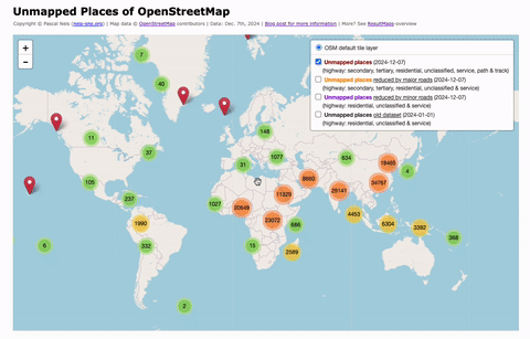
For the year 2024, I have recalculated this analysis and published the results on my website: “Unmapped Places of OpenStreetMap”. For the study, the OSM Planet File in PBF format from Dec. 7th was used. It can be downloaded here.


.jpg)


