OpenStreetMap logo OpenStreetMap

Diary Entries in English

Recent diary entries

I’ve suggested an updated version of the diagrams explaining the tagging of railway stations. The goal is to make them simpler to understand, especially for newcomers, without losing the core meaning. There have already been some feedback and interesting ideas for further improvements.

More complete tagging diagram

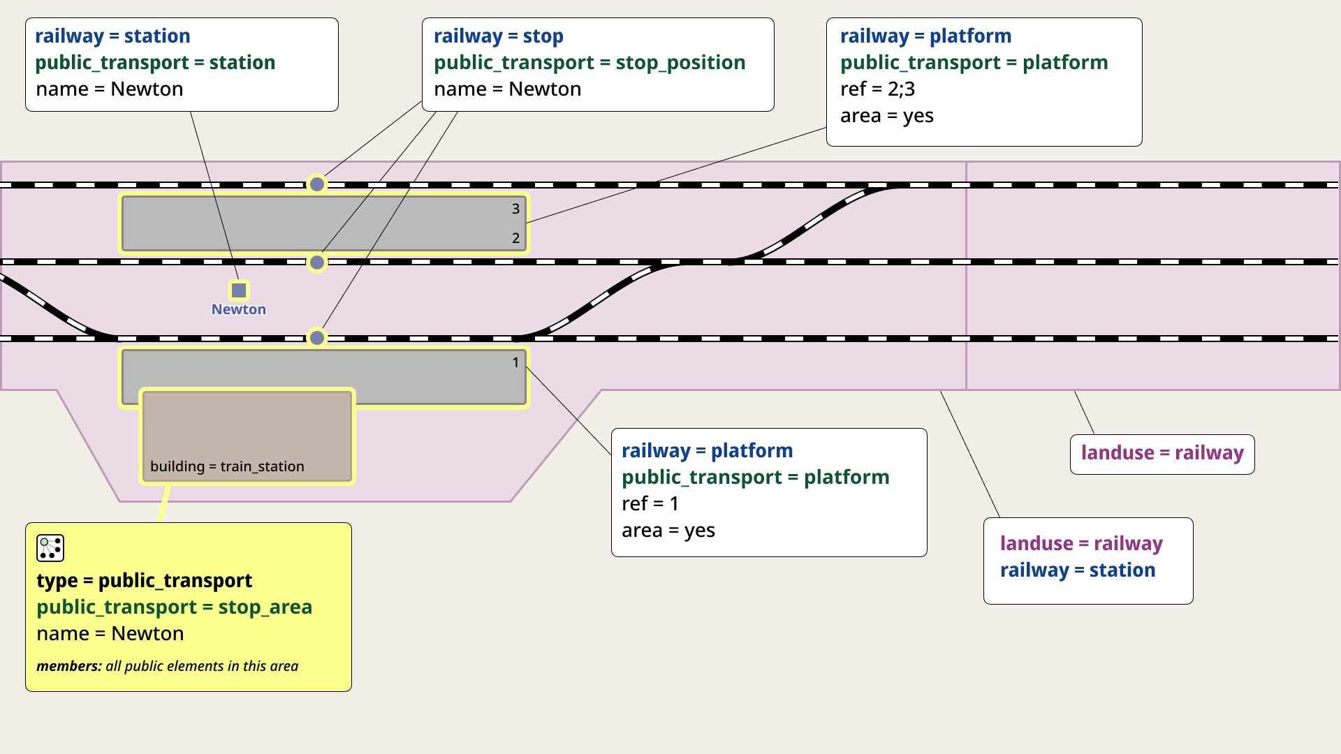
I invite you to join the discussion — your input would be highly appreciated!

Posted by laambda19 on 12 April 2025 in English.

Yanzi (燕子镇) Mapping Project

Overview

This is the first entry in a series of Chineese towns I plan to map out.

Considering the lack of mapping detail in the vast majority of China, I plan to add detail to those places which lack even the basics, such as Yanzi. At first, only the location of the town was mapped as well as a VERY rough outline of the residential landuse.

If there are any mistakes, please tell me! I tried my best to overcome the language barrier

Changes Made

  1. Fixed the town name
  2. Added road network
  3. Added buildings
  4. Added nearby villages/hamlets
  5. Added bodies of water and the Yanzixi Reservouir
  6. Various amenities (W.I.P.)

To-Do List

  1. Continue adding amenities
  2. Add nature landuse

Before

Before

After

See full entry

Location: Miaoling, Gaoqiao Village, Yanzi Town, Hefeng County, Enshi, Hubei, 445800, China

Greetings OSM community,

The Humanitarian OpenStreetMap Team (HOT) adapted its governance structure last year to open seats on the Board of Directors for non-members. We are now recruiting two (2) Appointed Directors. Applications are open until April 24, 2025 — visit HOT Careers for more information and to apply.

The main reason for introducing Appointed (as opposed to solely Elected) Directors is to bring in people—and skill sets—that are not currently in abundance within our voting membership. Of course, a passion for geospatial technology and data in humanitarian, disaster, and climate response is still desirable. However, we are particularly seeking individuals with expertise in financial sustainability, diversified fundraising, and innovative hybrid business models. Ideal candidates will have a proven track record of leading impact-driven organizations through strategic growth and transformation.

As the current Secretary of the HOT Board of Directors, I’m happy to answer any questions about this opportunity. We’re excited to welcome new perspectives and strengths that complement our existing Board, which brings deep OSM/HOT history and expertise.

Best regards, =Russ

Use Russell.Deffner (at) hotosm (dot) org if you’d like to email inquiries related to this position.

On Tuesday we had a London pub meet-up. We are still doing this every couple of months. I stopped writing diary entries about them, but for some reason (for your enjoyment!) I’ve decided to write about this one. So here goes:

We were at the Jack Horner Pub. It’s becoming the default choice in this bit of London where previously I would’ve chosen the Blue Posts (Sam Smiths pub. I still quite like them but there are reasons not to). Meanwhile Fullers make it quite easy to book a table on their website(s), so in uncharacteristically organised fashion, I booked table! but characteristically I arrived quite late. I only booked for 8 people, and that turned out to be about right on this occasion. A small intimate gathering.

We had along Json Singh from india, who just moved to London. I like the way he’s named himself after a file format (I was forgetting to ask him about that). So we talked to him about the state of mapping in India. It sounds like it’s progressing well with lively communities in the cities, although sometimes struggling to build formal organisations, partly because it’s a little bit illegal there, so has to remain a bit underground. That’s mostly because of tensions around showing of borders. I wonder whether vector tiles will soon allow us to do the same slight-of-hand trick that other map providers do, showing different border positions depending on your IP address location. It’s kind of comical how well that trick seems to work to take the heat off. Another thing which is daft, is that there’s no official openly published data on the border position which officially must be shown on maps of india. That would be a basic way of helping assert a particular desired border position. But no.

See full entry

Location: Saint Giles, Bloomsbury, London Borough of Camden, London, Greater London, England, WC2H 8LG, United Kingdom
Posted by kumakyoo on 11 April 2025 in English. Last updated on 25 April 2025.

This blog post is part of a series of blog posts about the new OSM file format “OMA”. This is the sixth post. At the end of the article you’ll find links to the other blog entries.


The Oma file format uses a set of bounding boxes to sort the data geographically. The default set used by the converter consists of three grids.


The Default Grids

The first grid uses a mesh size of 1 degree in both directions between -45° and 45° latitude. Towards the poles the mesh size increases and finally the area around the poles is put into a single bounding box.

The grid looks like this:

the default bounding box grid, level 1

The second grid uses a mesh size of 10 degrees in both directions between -80° and 80° latitude. It does not include the areas around the poles.

This grid looks like this:

See full entry

Posted by rphyrin on 11 April 2025 in English. Last updated on 13 April 2025.

“Before 2011, if you asked most cartography professionals, they’d say OpenStreetMap was a toy. The turning point for me was a photo of a firefighter from a search and rescue team using a handheld GPS device—they used OSM maps to coordinate efforts after the Haiti earthquake.”

“During natural disasters like Haiti in 2011, nearby countries send search and rescue teams, and organizations like Doctors Without Borders and the Red Cross deploy. They requested a map to set up a field hospital. The Haitian government was basically like, “What? How?” So you go to Google Maps, right? Like anyone would. But there was nothing—Haiti had no commercial map coverage at the time. Even if there had been, it was likely destroyed. Then we showed up—just four OSM geeks—because nobody else cared about geographic data. With the help of 500 volunteers with iPhones, we mapped the entire street network of Port-au-Prince in a week. That map allowed NGOs to move through the city and save lives. It was a turning point—after that, the World Health Organization started listening to us.”

Flyers (April 3, 2025) “Expertos en cartografía: OpenStreetMap es la Wikipedia de los mapas” Medio Multimedia


See full entry

🎉 We’re honored to share that our chapter has received the Mapping Metrics Award 2024 from YouthMappers! 🏆🗺️ This recognition celebrates high-performing chapters making consistent and quality contributions to OpenStreetMap — and we’re proud to be among them!

Mapping Metrics Award 2024 from YouthMappers 
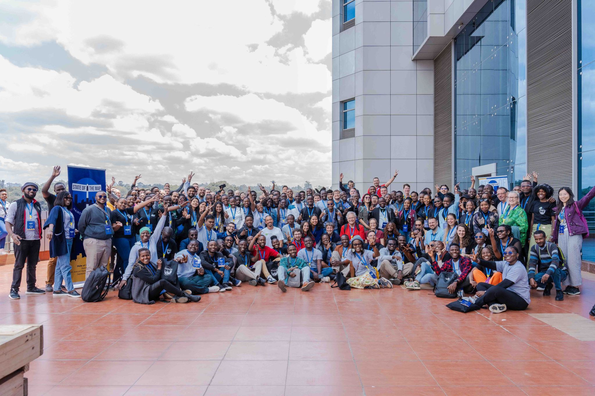
Huge thanks to our amazing team of mappers whose hard work and passion made this possible. 💪🌍 Let’s keep mapping for impact and making a difference together! #YouthMappers #MappingForImpact #MappingMetricsAward #OpenStreetMap #OSM #GeoYouth #ProudMoment

Location: Navy Co-operative Housing, Akran, Savar Subdistrict, Dhaka District, Dhaka Division, 1345, Bangladesh

Guia Rápido: Ativando as Imagens Aéreas da Bing no JOSM.

Ao utilizar o JOSM para editar o OpenStreetMap, é essencial contar com boas imagens de fundo para garantir a precisão do mapeamento. A camada de imagens aéreas da Bing é uma das mais populares entre mapeadores por sua boa resolução e ampla cobertura. Neste guia rápido, você vai aprender como alterar as configurações do JOSM para ativar essa camada de forma simples e eficiente.

Ideal para quem está começando ou precisa ajustar o editor para um novo ambiente de mapeamento.

Link do Video https://www.youtube.com/watch?v=UyH6OFRqNkg

Baixe o arquivo de configuração bing.attribution.xml no link. https://projeto.softwarelivre.tec.br/s/xweLgASyTqCzoWp

mais detalhes de como configur: https://projeto.softwarelivre.tec.br/s/dMLsSXyQqXSbPqz

Quick Guide: Enabling Bing Aerial Imagery in JOSM.

When using JOSM to edit OpenStreetMap, it is essential to have good background imagery to ensure accurate mapping. The Bing aerial imagery layer is one of the most popular among mappers due to its high resolution and wide coverage. In this quick guide, you will learn how to change the JOSM settings to enable this layer in a simple and efficient way. Ideal for those who are just starting out or need to adjust the editor to a new mapping environment.

Video Link https://www.youtube.com/watch?v=UyH6OFRqNkg

Download the bing.attribution.xml configuration file from the link. https://projeto.softwarelivre.tec.br/s/xweLgASyTqCzoWp

more details on how to configure: https://projeto.softwarelivre.tec.br/s/dMLsSXyQqXSbPqz

Made in Tanzania, serving Global

March 2025 wasn’t just the end of a cohort—it marked the beginning of a movement.

At the Better Tomorrow Program Cohort 1 Closing Ceremony hosted by ROOTGIS, we saw young innovators pitch projects that tackled everything from waste management to housing access. But one powerful element tied these innovations together—geospatial intelligence powered by open data. And more specifically: OpenStreetMap. A group photo

🗺️ Why OpenStreetMap Matters

OpenStreetMap (OSM) is more than a map—it’s a platform. A canvas. A growing, living dataset built by volunteers and available to everyone. In a country like Tanzania, where commercial mapping tools are often inaccessible or outdated, OSM becomes a critical tool for innovation.

See full entry

Leaving my country, Nigeria, to attend the 2024 SOTM conference at the University of Nairobi, Kenya was a thrilling and enlightening experience for me. The whole event immersed me in the dynamic world of open mapping. The conference brought together various groups of professionals in the field of open mapping and it was great to finally see them in person. Most importantly, I was able to reconnect with YouthMappers Regional Ambassadors, fellow YouthMappers from Africa, Asia, America and wonderful OSM contributors from the globe. Imgur

See full entry

Location: Ngara East sublocation, Ngara location, CBD division, Starehe, Nairobi, Nairobi County, Kenya

This is part of a series of blogs about my journey working on a collaborative Field Mapping tool, now called FieldTM:

pt1 here.

pt2 here.

pt3 here.

pt4 here.

Field Mapping: The Past

Paper Era

  • People actually used to have to write things down on paper, remember information in their heads, and talk to one another - damn! However ever did they manage?

  • In all seriousness, coordinating a mapping campaign before the 1990’s was probably a logistical nightmare. Paper maps, scrawled notes by field teams that had to be coordinated at the start of the day, then sent on their way.

  • No doubt, labour intensive and prone to error.

Digital Transition

  • With the advent of handheld GPS devices in the 1990s and early 2000s, digital coordinates could be logged in the field.

  • Paired with rugged PDAs or laptops running early GIS software like ArcPad, fieldwork became more accurate and geospatially aligned - but the workflow was still often clunky and required post-field data syncing.

    1990s-toughbook

See full entry

Location: East Marylebone, Fitzrovia, Camden Town, City of Westminster, Greater London, England, W1T 3PP, United Kingdom

Você já parou pra pensar no que essa imagem representa na vida de quem tenta encontrar um endereço e não consegue?

Você já parou pra pensar no que essa imagem representa na vida de quem tenta encontrar um endereço e não consegue?

Pra quem mora em um bairro onde a rua sequer tem nome no mapa? Pra quem chama um Uber ou 99 e o motorista não encontra o local? Ou pra um estudante que precisa fazer um trabalho de faculdade, mas as ruas da sua comunidade nem aparecem direito no mapa? Isso tem um nome: dignidade.

Dignidade é poder dizer onde você mora. É receber suas compras online.

É chamar um carro de aplicativo sem preocupação. É poder passar seu endereço pra um amigo, pra um parente, pra um vizinho. As prefeituras, o governo estadual e federal deveriam olhar com mais seriedade para o registro de ruas, bairros, vilas e distritos. Se isso fosse feito de forma justa e abrangente, o Brasil não seria esse imenso vazio cartográfico, onde tantas ruas seguem sem nome.

See full entry

Posted by Opie Eke Ogburu on 5 April 2025 in English.

On the 28 of March, I just discovered that our Village is not well represented in the wikipedia map, as well as the article about our community on wikipedia is not comprehensive, as i was researching further about my local community online.

That was the beginning of my journey on openstreetmap, as I’ve decided to become a contributor to help improve the visibility of our community on the world map.

Though I’m starting as a novice as at today been the 4th of April, 2025, I’m determined to walk myself through the process of learning how to edit on open street map. As I’ve started on a self learning steps, I look forward to maybe joining a community of mappers, finding someone as a guide and becoming a full member of openstreetmap community.

Location: Ohafia, Abia State, Nigeria
Posted by kumakyoo on 4 April 2025 in English. Last updated on 25 April 2025.

This blog post is part of a series of blog posts about the new OSM file format “OMA”. This is the fifth post. At the end of the article you’ll find links to the other blog entries.


When relations where introduced (in 2008, if I remember correctly) I was a big fan of them. They sounded great and promising. Meanwhile I think, it was a mistake to add relations, and if I where to decide I would probably remove them from OSM and replace them with something better.

Let’s have a closer look: Nodes and ways (and areas) are simple: A geometry with some properties. Relations do not share this simplicity. They share the properties, but they do not have their own geometry. Instead, they contain references to some elements. This makes things complicated.

I could write several articles about relations and why I think they are a bad idea, but this article is about relations in Oma files, so I’ll leave it at that for now.


Multipolygons

Instead, I’m going to take a closer look at what is currently done with relations. According to taginfo, more than half of all relations are multipolygons, that is, a collection of areas. Since we’ve already got areas in Oma files, this is easy to handle: All multipolygons are converted to one or more areas.

See full entry

In 1973, Gunther W. Holtorf was assigned as the manager of Lufthansa in Indonesia.

From his first year working in Jakarta, many friends and visitors from abroad frequently asked him to act as their guide in the city. To assist his guests, despite having no formal background in cartography, he began sketching maps of Jakarta. His work proved useful and well-received, encouraging him to create a more detailed and comprehensive map of the city.

To achieve this, he initially approached the Jakarta City Planning Office. Instead of obtaining the topographic maps he sought as a base, he only found outdated maps of the city. This situation led the local civil servants to encourage him to produce a new map.

Gunther accepted the challenge. Every weekend, he explored Jakarta, navigating its narrow alleys and streets by foot, bicycle, and car. In addition to his weekend excursions, he also dedicated time each morning from 6:00 to 9:00 before heading to his office.

See full entry