As in my profile, yes I’ve been addicted to https://blacket.org for a while. If anyone joins it and wants to reach out, my username is 76 ingame and my discord username is .i76. (76). Just editing the overnight camp I attend right now. Being bored.
Diary Entries in English
Recent diary entries
Another year has passed since my last entry, and it’s about two years ago that I resided in Bonaire for half a year. I want to visit again, but there’s that man on the side of my shoulder whispering things about a sustainable world :) (Meaning I can’t simply visit for a couple of weeks, but should stay for a longer period of time.)
Last year (2024), the Dutch government made high resolution aerial photos of Bonaire. I’ve already updated and mapped several areas based on this. As this information is both high resolution and recent it is very useful for mapping. You can find more information about this on https://www.beeldmateriaal.nl/dataroom-caribisch-nederland
In 2023 I stayed at the Hausmann Follies apartment complex. To compare the image quality, look at these photos:
Bing resolution:

Posted by martien-176 on 12 August 2025 in English.
Last updated on 13 August 2025.
Introduction
Humanitarian Openstreetmap Team (HOT) is an international team dedicated to humanitarian action and community development through open mapping.
Accurate and up-to-date data is essential for effective humanitarian response. Validators use tools such as JOSM and the HOT Tasking Manager to identify and flag errors and mistakes. From experience, i know that this is a complex and time-consuming endeavor.
One tool to save time and enhance the validation process is OSMCha.
The funding for OSMCha is currently at risk, which could lead to the degradation of this invaluable tool. In this diary, i want to highlight the essential role OSMCha plays in my own (and other’s) validation and quality maintenance workflow.
What is OSMCha

OpenStreetMap Changeset Analyzer (OSMCha) is a tool designed to monitor and analyze changes made to OpenStreetMap data. It enables data validators to quickly identify potential issues, track changes, and ensure data quality.
peraia δευκαλιωνος 35
In collaboration with a local team in Grünstadt, Mannheimer Mapathons e.V. completed the mapping of the historic Jewish cemetery in early 2024 after five months of data collection. The cemetery was used by the important Jewish community from around 1700 to around 1937 and comprises 464 gravestones that are still visible. A high-precision Sparkfun RTK Facet GPS receiver was used for the survey. A map has been available online since May 2024. In recent weeks, with the support of the Heidelberg University of Jewish Studies, the names and dates of many of the oldest purely Hebrew gravestones have been catalogued and integrated into the map data. The translation work will continue with the aim of supporting both descendants and historical research.
In Zusammenarbeit mit einem lokalen Team in Grünstadt hat Mannheimer Mapathons e.V. nach fünf Monaten Datenerhebung Anfang 2024 die Kartierung des historischen jüdischen Friedhofs abgeschlossen, berichtet RCD49. Der Friedhof wurde von der bedeutenden jüdischen Gemeinde etwa von 1700 bis ca. 1937 genutzt und umfasst 464 noch sichtbare Grabsteine. Für die Erfassung kam ein hochpräziser Sparkfun RTK Facet GPS-Empfänger zum Einsatz. Seit Mai 2024 ist eine Karte online verfügbar. In den letzten Wochen wurde mit Unterstützung von der Hochschule für Jüdische Studien in Heidelberg begonnen, Namen und Daten von vielen der ältesten rein hebräischen Grabsteine zu erschließen und in die Kartendaten zu integrieren. Die Übersetzungsarbeit wird fortgesetzt, mit dem Ziel, sowohl Nachkommen als auch historische Forschungen zu unterstützen.
Posted by JWillLabrador on 10 August 2025 in English.
I have continued mapping Happy Valley Goose Bay. I noticed that the ESRI world imagery isn’t particularly good. I could do with some more or better data, and I may have to do some drone flights to get it.
I have also started to reach out for data in the surrounding towns.

Bliss
Map update during Summer Holidays mostly using StreetComplete, Osmand, JOSM
Hello!
I’ve been mapping in OpenStreetMap for a few years now, and I believe the current method of mapping routes is quite painful and wastes hours of editors’ times to just upkeep it,
So, here is my idea on how we could fix it.
The Idea
In essence, it is to have just one start node and one end node, the router (using the bus profile) then calculates the route deterministically, with additional points in between added only as needed to achieve the desired path.
For example, in the case above, the route can be simplified from 123 ways down to just 5 nodes representing the path. (In reality there would be nodes at every station, so it wouldn’t be as few as 5)
This approach is;
-
Resilient to edits,
-
So many times easier to maintain.
 I’ve compiled Valhalla on Linux and created a quick proof of concept program showing this can already be implemented (unofficially) in custom code.
Posted by Brazil Singh on 8 August 2025 in English.
Last updated on 12 August 2025.


About Me
I am Brazil Singh, an open mapping advocate, digital innovator, web developer, and community leader from Bangladesh. As an Open Mapping Guru at the Open Mapping Hub Asia-Pacific, I equip communities with practical and impactful mapping skills. I play a key role in managing social media for the OSMF, and actively contribute as a volunteer in the OSMF Local Chapters and Communities Working Group (LCCWG).
As a dedicated mapper, trainer, community organizer, and advocate, I have worked with the OSM ecosystem at local, regional, and international levels. From mapping in flood-affected areas of Thailand to mentoring YouthMappers across Asia and beyond, to volunteering with HOT and the OSMF Communication Working Group, I have seen firsthand how collaboration can create meaningful impact.

State of Michigan
- Harrisville (from 2011 to now)
- Harrisville State Park (from 2011 to now)
- Sault Ste. Marie (2021)
- Tahquamenon Falls State Park (unknown)
- Pictured Rocks National Lakeshore (2021)
State of North Carolina
- Lake Lure (2022)
- Chimney Rock (2022)
State of Wyoming
- Yellowstone National Park (2020)
Posted by Raquel Dezidério Souto on 8 August 2025 in English.
BOOK RELEASE IN THE III WORKSHOP ON PARTICIPATORY MAPPING AND SOCIAL CARTOGRAPHY - MPCS 2025
The book “Case studies in collaborative and participatory mapping” (original Estudos de caso em mapeamentos colaborativo e participativo) is a collective work, organized by Dr. Raquel Dezidério Souto, which includes 20 chapters with reports on research that adopted collective mapping methodologies - collaborative or participatory and social cartography, in the five regions of Brazil and for a wide variety of purposes, from nature conservation to the recognition of traditional communities, the inventory of urban infrastructure, and the enhancement of historical and cultural heritage. We hope that its publication will shed light on the importance and applicability of these methodologies and contribute to expanding the network of knowledge around this theme.
The book release date has been set: August 29, 2025, at 4 p.m. (UTC-3), with live streaming on the IVIDES YouTube channel
The complete schedule of the Workshop MPCS 2025 is now available here.
See you in August at this 100% online event, which is completely open to the public. The registration is available on the official website
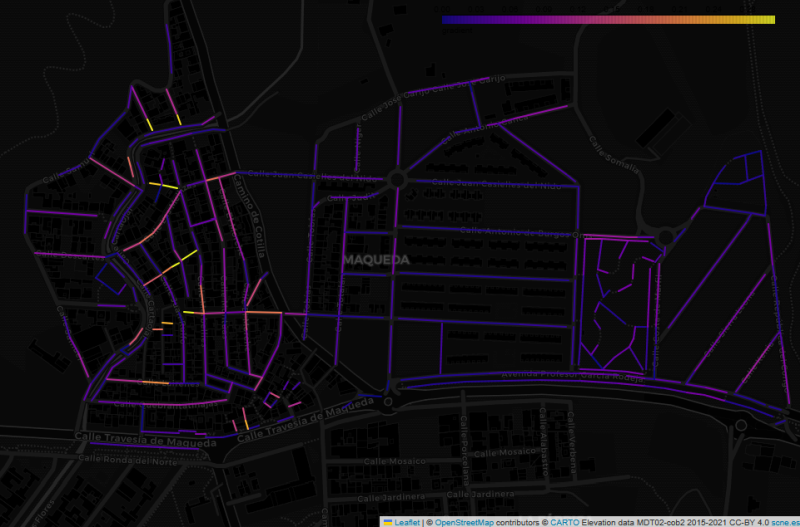
This image shows the Maqueda barrio in Malaga, with streets colour-coded by estimated gradient. The flat area to the east shows up with cold colours, while the western part of the barrio, which straddles a ridge, generally has warmer colours. But why did I make this map, and what does it have to do with “streets that are really steps”?
In my wanderings around the city of Malaga, I have often come across flights of steps that are not tagged as highway=steps in OpenStreetMap. Usually they are tagged as residential or footway, with misleading results for anyone using OSM-based maps or routers to find their way around the city.
I started mapping on 7 of August using StreetComplete. I discovered (unfortunately) that I understood some criteria concerning road smoothness wrong, and I was no longer sure if my edits from the first day were correct, so I decided to delete most of them, to remap and do it properly. Furthermore, I apologize if anyone had any inconvenience of my poor first mapping steps.
I will stick to mapping and hope to improve in the future. :)
To day I added new apartments at Stabekk https://smedens-hage.no
“OSM Latest Changes” (https://rene78.github.io/latest-changes/) just got a few updates to make exploring recent edits more insightful - and smoother!
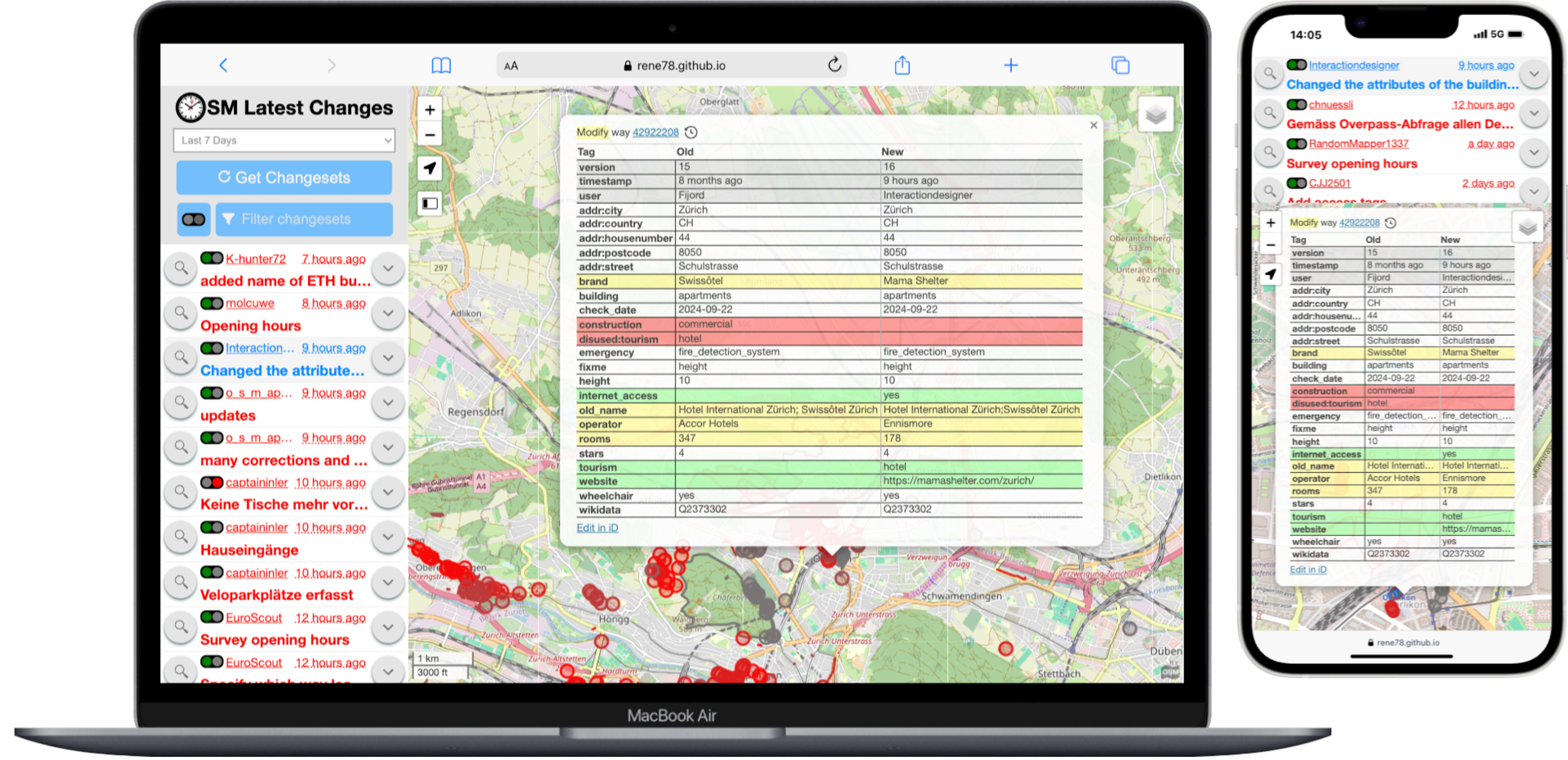
New changeset info panel
Opener
Woah, I didn’t realize how quickly this would be something I’d like. I know my account has been around since 2022, but I seriously started mapping in mid-2025. ~10k Edits pretty quickly, and turns out I enjoy editing the map. Maybe I’m looking for a job around this kind of work… Who knows.
ALPR’s
Automated License Plate Readers… Man these things are poping up everywhere. I stumbled on Deflock.me recently. I don’t agree with their “Why” but, I don’t agree these things are good for society… I get that we don’t have a “right to privacy” in public spaces, but man…. this seems one flew over the coo koo’s nest. Is pervasive surveillance at this scale really that surprising? My county alone has 95 ALPR’s (mostly by flock) running 24/7/365 rain snow or shine…. That’s 1 camera per 22 sq.mi. or 1 camera per 7700 people.
Its not right…
95 Cameras over 2130 square miles, and estimated 730,000 people.
I like technology and adapting it for the sake of technology . I am not addicted to yet we can not escape it. I only carry my phone when necessary , a computer works so much better , a mix of the old and the new ,technology moves very quickly . I’d prefer a GPS to a 5G modem ,API are not as readily available now
Posted by IsStatenIsland on 2 August 2025 in English.
Last updated on 30 August 2025.
Update from August 29th: I’ve upgraded the speeds back to 160. What a crazy exercise of futility. One day later I also obtained summary bulletin order describing most of the changes. There’s still a little more work to do.
Update from August 11th: There are ramblings about the maximum speeds already being changed since July, before I even made this post. I may have shot myself in the foot here although the original editor of the edits I “reverted” presumably didn’t know about the actual rule changes either.
I’ve tried requesting the newest ETT on August 8th and I received the same ETT I already had. The speed changes may have been issued by general order without a general ETT update. As I still have no hard evidence, I can’t yet modify the speed limits yet. It may be necessary to wait for revenue service if nobody can point me to the document I need to request.
On the bright side while going through all of this, I had a chance to closely review speed limits in the Rhode Island and Massachusetts areas. The editors (presumably stevea at least at first) had a solid understanding of the speed change boundaries.
While researching the editor(s), I encountered a changeset that has a URL to yet another ETT I don’t have. Amazing.
End updates
https://archive.org/details/AMTK-NEC-employee-timetable-20250505-si
This is the most up to date Northeast Corridor Employee Timetable (ETT) I’ve requested, published May 5, 2025. It contains Amtrak’s maximum authorized speeds on the Northeast Corridor. The Acela 2’s planned speeds (mostly focusing on changing 150 to 160 mph) have not yet been integrated into the rules by Amtrak, despite the observed or assumed compatibility with 160 mph service by track class, catenary structure or demonstration in recent test runs. The current runs remain just that: test runs.
Welcome to my diary, “Where did I macro-mapped” This will be available in English and not Italian cuz: 1. I need to speak better english 2. I will (not now but not far away) wanna macro-mapping in the USA (i heard that they have absolute good imagery!) 3. Wanna move from Italy and go to Wisconsin, USA. — Where did I micro-mapped? I micro-mapped Tre Ponti Est (service plaza/rest area/or whatever you call it) look it in 3d, look it in 2d changeset I also micro-mapped the nearby service plaza/rest area, Tre Ponti OVEST, look it in 3d, look it in 2d, changeset 1, changeset 2 — (If you are looking from when I published. UTC+2 02/08/2025 23:30 or Wisconsin Time 02/08/2025 16:30, The Tre Ponti Ovest is not available cuz of cooldown aka [waiting server](https://en.wiktionary.org/wiki/waiting#:~:text=waiting%20(countable,%2C%20service.)