Adam Franco's Comments
| Changeset | When | Comment |
|---|---|---|
| 135120562 | over 2 years ago | Please note, this was an attempt based on several days of driving through this area, but my local knowledge is that of a visitor rather than resident. I may have missed some roads that should be upgraded or chosen the wrong one of two parallel roads connecting hamlets. |
| 134885369 | over 2 years ago | The move away from expressway==trunk toward splitting those meanings into a separate expressway=yes and highway=* meaning connectivity-importance involved 17 participants on almost 70 messages on the [talk-us] mailing list beginning in May 2021 followed by more than 50 participants writing over 4,000 messages in the #highway-classification channel of the OSM-US Slack up to May 2022, with many more since. I talked about this history at SOTM-US last year: https://youtu.be/jWQUldGg43A Rather than hiding the distinct American concept of expressways, we're actually trying to highlight them by shifting to a distinct expressway=yes tag that explicitly and clearly means what it says. America is a place of much varied and patchwork infrastructure with many highways getting upgraded to expressway-level infrastructure in segments. While OSM-Carto does not support distinct rendering of this tag, other renders do. See the Austin, TX area in the OSM-Americana renderer for a good example of a mixture of highway=primary+expressway=yes roads that connect within the city as as well as highway=trunk roads that connect between important regional centers that alternate between expressway-level infrastructure and not:
I don't have local knowledge of the roadway at hand and which sections are expressways or not, but I can see that it parallels a motorway and isn't itself the main connector between significant regional cities. highway=primary probably makes sense if it is the most important local road within a city. |
| 134885369 | over 2 years ago | As described in osm.wiki/United_States/2021_Highway_Classification_Guidance , `highway=trunk` is not to be used for indicating enhanced "expressway"-type construction, but rather the regional connectivity importance of a road. If this does have mostly "expressway" character, then use "highway=primary|secondary|etc" to indicate the level of regional connectivity importance and add "expressway=yes" to indicate the enhanced level of infrastructure. See osm.wiki/Key:expressway for further details on this tag. |
| 125411898 | over 2 years ago | This seems like a pretty short section of limited-access to classify as a motorway. Maybe maintaining highway=trunk + expressway=yes would better capture the situation. |
| 125411941 | over 2 years ago | This seems like a pretty short section of limited-access to classify as a motorway. Maybe maintaining highway=trunk + expressway=yes would better capture the situation. |
| 125414770 | over 2 years ago | This seems like a pretty short section of limited-access to classify as a motorway. Maybe maintaining highway=trunk (or other class) + expressway=yes would better capture the situation. |
| 125590734 | over 2 years ago | This seems like a pretty short section of limited-access to classify as a motorway. Maybe maintaining highway=trunk + expressway=yes would better capture the situation. |
| 125426351 | over 2 years ago | This seems like a pretty short section of limited-access to classify as a motorway. Maybe maintaining highway=trunk + expressway=yes would better capture the situation. |
| 131898770 | over 2 years ago | @Udarian, please read through at least the whole "Approach" and "Classification" sections of: osm.wiki/United_States/2021_Highway_Classification_Guidance Over the past few years, the US community is shifting from "what does it look like" definition of highway=trunk to a "what purpose does it serve in regional connectivity" definition. If you are zoomed way out to see the whole state of Florida, what is the route between West Palm beach and Cape Coral? Or Port Saint Lucie to Sarasota? That is the level of regional connectivity that highway=trunk is implying. While that particular viaduct serves a very significant destination, even MIA itself is a destination local to only Miami and its surrounding communities. The airport itself isn't as regionally significant a destination as a city itself. Whether the cargo terminal is of similar significance as other nearby highway=primary roads (US-41, FL-953, FL-948, etc) or is of similar significance to the nearby highway=secondary roads (FL-968, Northwest 25th St, etc) is something that I don't have the local knowledge to guess at. |
| 109655423 | over 2 years ago | Hi Alex, I just noticed that this changeset added boundary=administrative+admin_leve=9 to the way that makes up the Bristol village boundary=census.
I haven't checked yet to see if additional cases of this got in, but these census boundaries shouldn't have an admin_level or boundary=administrative tag on them. |
| 128367504 | over 2 years ago | I drove through the newly opened roundabout a few times over the past week and just wanted to say thanks for the prompt updates! |
| 128856020 | over 2 years ago | Hi Dave! Good point on the 50mph speed limit -- that is a big distinction from the other roads. Welcome to OSM editing, by the way! :-) - Adam |
| 128856020 | over 2 years ago | Hi salmo6, thanks for your edits and contributions. I'm curious as to why you upgraded VT-23 from tertiary to secondary? While this road has a state-designated route number it is not maintained by VTRANS and is instead a Town-maintained road. It is slightly better-maintained than other roads in Weybridge, but doesn't server as a particularly significant connector. Secondary could be appropriate or tertiary. This is something of a borderline case as far as I can tell. |
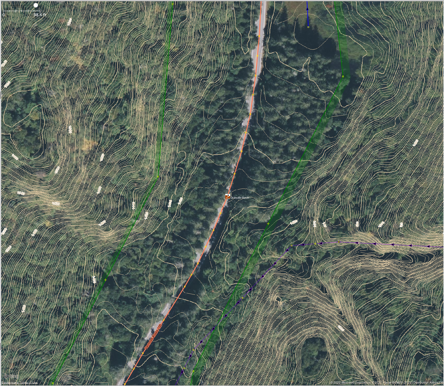
| 128988911 | over 2 years ago | Here is a image of the 4cm VCGI LIDAR contour lines. I may have misinterpreted the contours when looking the first time, the saddle may be close to or slightly to the west of the road rather than to the east. Here's a screen shot:
|
| 128988911 | over 2 years ago | Why did you merge the natural=saddle node with the mountain pass node? As has been discussed in our local forum: "mountain_pass=yes is for the high point where a road goes over a mountain pass and natural=saddle is for the low point between two peaks whether there's a road or not. These might be in the exact same spot, or they might not be." Looking at the LIDAR contour lines for this area (we have recent 4cm LIDAR available), the actual physical saddle is not located on the road bed and instead to the east closer to the location of the node you deleted. |
| 126996676 | almost 3 years ago | I see this changeset modified the name from "Mary Hogan Elementary School" to "Mary Hogan School". Looking at the school's website
|
| 125377567 | almost 3 years ago | @sdvm In the US mappers are regularly using expressway=yes to indicate enhanced construction that doesn't quite meet motorway standards. See osm.wiki/United_States/2021_Highway_Classification_Guidance for details. Was there a particular reason other than the existence of interchanges that you feel that highway=motorway is more appropriate in this case? |
| 125586349 | almost 3 years ago | Reverted in: osm.org/changeset/125875988 |
| 125586349 | almost 3 years ago | A short elevated pair of exchanges like this does not meet the current criteria for highway=motorway in the US. See: osm.wiki/United_States/2021_Highway_Classification_Guidance These short limited access but not quite motorway sections are better described by a highway=* value that describes their connectivity importance with the addition of expressway=yes to denote their enhanced construction. |
| 122821115 | about 3 years ago | For this particular road which is connecting I-287 to the highway=primary NY-22, it would seem reasonable to classify it as either highway=primary or highway=secondary in spite of the ACC=4. Being a significant connection between the primary and trunk/motorway networks would lend weight to calling it primary, though I'd also be OK with secondary as well. |