Adam Franco's Comments
| Changeset | When | Comment |
|---|---|---|
| 131898770 | over 2 years ago | @Udarian, please read through at least the whole "Approach" and "Classification" sections of: osm.wiki/United_States/2021_Highway_Classification_Guidance Over the past few years, the US community is shifting from "what does it look like" definition of highway=trunk to a "what purpose does it serve in regional connectivity" definition. If you are zoomed way out to see the whole state of Florida, what is the route between West Palm beach and Cape Coral? Or Port Saint Lucie to Sarasota? That is the level of regional connectivity that highway=trunk is implying. While that particular viaduct serves a very significant destination, even MIA itself is a destination local to only Miami and its surrounding communities. The airport itself isn't as regionally significant a destination as a city itself. Whether the cargo terminal is of similar significance as other nearby highway=primary roads (US-41, FL-953, FL-948, etc) or is of similar significance to the nearby highway=secondary roads (FL-968, Northwest 25th St, etc) is something that I don't have the local knowledge to guess at. |
| 109655423 | over 2 years ago | Hi Alex, I just noticed that this changeset added boundary=administrative+admin_leve=9 to the way that makes up the Bristol village boundary=census.
I haven't checked yet to see if additional cases of this got in, but these census boundaries shouldn't have an admin_level or boundary=administrative tag on them. |
| 128367504 | over 2 years ago | I drove through the newly opened roundabout a few times over the past week and just wanted to say thanks for the prompt updates! |
| 128856020 | over 2 years ago | Hi Dave! Good point on the 50mph speed limit -- that is a big distinction from the other roads. Welcome to OSM editing, by the way! :-) - Adam |
| 128856020 | over 2 years ago | Hi salmo6, thanks for your edits and contributions. I'm curious as to why you upgraded VT-23 from tertiary to secondary? While this road has a state-designated route number it is not maintained by VTRANS and is instead a Town-maintained road. It is slightly better-maintained than other roads in Weybridge, but doesn't server as a particularly significant connector. Secondary could be appropriate or tertiary. This is something of a borderline case as far as I can tell. |
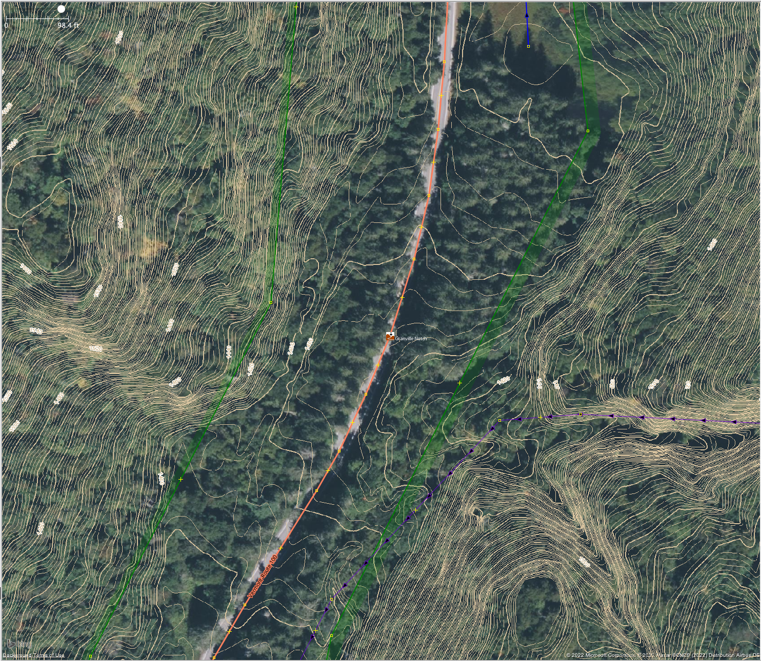
| 128988911 | over 2 years ago | Here is a image of the 4cm VCGI LIDAR contour lines. I may have misinterpreted the contours when looking the first time, the saddle may be close to or slightly to the west of the road rather than to the east. Here's a screen shot:
|
| 128988911 | over 2 years ago | Why did you merge the natural=saddle node with the mountain pass node? As has been discussed in our local forum: "mountain_pass=yes is for the high point where a road goes over a mountain pass and natural=saddle is for the low point between two peaks whether there's a road or not. These might be in the exact same spot, or they might not be." Looking at the LIDAR contour lines for this area (we have recent 4cm LIDAR available), the actual physical saddle is not located on the road bed and instead to the east closer to the location of the node you deleted. |
| 126996676 | almost 3 years ago | I see this changeset modified the name from "Mary Hogan Elementary School" to "Mary Hogan School". Looking at the school's website
|
| 125377567 | almost 3 years ago | @sdvm In the US mappers are regularly using expressway=yes to indicate enhanced construction that doesn't quite meet motorway standards. See osm.wiki/United_States/2021_Highway_Classification_Guidance for details. Was there a particular reason other than the existence of interchanges that you feel that highway=motorway is more appropriate in this case? |
| 125586349 | almost 3 years ago | Reverted in: osm.org/changeset/125875988 |
| 125586349 | almost 3 years ago | A short elevated pair of exchanges like this does not meet the current criteria for highway=motorway in the US. See: osm.wiki/United_States/2021_Highway_Classification_Guidance These short limited access but not quite motorway sections are better described by a highway=* value that describes their connectivity importance with the addition of expressway=yes to denote their enhanced construction. |
| 122821115 | about 3 years ago | For this particular road which is connecting I-287 to the highway=primary NY-22, it would seem reasonable to classify it as either highway=primary or highway=secondary in spite of the ACC=4. Being a significant connection between the primary and trunk/motorway networks would lend weight to calling it primary, though I'd also be OK with secondary as well. |
| 122821115 | about 3 years ago | Hi FlowerHillPerson, I just took a look at NYS_Streets and see that the DOT gave this street an Arterial Classification Code (ACC) of 4, which we've been generally been mapping to highway=secondary across the state. Screenshot of this area from NYS Streets:
In cases like this where this where the road is divided and limited access we use the the expressway=yes tag to indicate the improved physical construction, leaving highway=trunk for inter-regional connectivity importance. In the Americana map view you can see a few cases of lower-classed expressways around Albany:
|
| 120614859 | about 3 years ago | Hi there and welcome to OSM! I took a look at your changes and it looks like the opening_hours needs a fix to be correctly understood by tools that use OSM data. I believe that the value you want is:
The opening_hours specification is a bit complicated (see osm.wiki/Key:opening%20hours ) but this evaluation tool can be helpful for validating the format:
Reply if you have any questions.
|
| 113428830 | over 3 years ago | Here's the link to the OSM-US Slack if you haven't joined: https://slack.openstreetmap.us/ |
| 113428830 | over 3 years ago | Hi rickmastfan67, thanks for the feedback. I'm local to the Adirondacks and spend some time in the Rochester area, but haven't been to this area south of Buffalo. The NYS Streets is a very good indicator, but not perfect. See: osm.wiki/Proposal:_New_York/Highway_Classification for details. I'm totally open to the idea that NYS Streets has the priority of NY-5 and US-20 wrong and that NY-5 should be the primary for that segment. Most of the conversation on highway classification in NY and nationally has been taking place in the OSM-US Slack's #local-newyorkstate and #highway-classification channels. It would be great to get more feedback from western NY mappers as we still need to figure out more of the lower-classes now that the motorway/trunk network is better sorted out. Best,
|
| 118614405 | over 3 years ago | Thanks for the documentation prompt. I've merged the text that was on osm.wiki/United_States_admin_level#Unincorporated_areas into osm.wiki/United_States/Tags#Places so that there is now a single US-specific definition of the place=* hierarchy instead of two inconsistent versions. I've also added the distinction between admin_level=* and place=* to the latter section. Best,
|
| 118614825 | over 3 years ago | Hi Fred, I bulk reverted the changesets that just had a comment "change a town to a village" or similar. I missed that the population was also changed in this changeset. It should be able to be updated independently without changing the classification of the place and is easier to identify what is valid than the judgement call that the place level demands. Best,
|
| 118614405 | over 3 years ago | Ah, yes, I see what you are looking for. It's not actually wrong to have different admin-levels and place=* values in the US. The admin-level is specifically tied to the governmental organization of an area. Different parts of the country have different nested levels of administration. In contrast to adminstration, the place=* value has more to do with the size and regional importance of the community, regardless of administrative boundaries. In my part of the New England region we have Town government (admin_level=8). The actual collections of development within these administrative areas may or may not be incorporated and may have population and amenities that make them place=hamlet, villages, OR town. If a sub-area of the Town *is* incorporated then it will have an additional admin_level=9 boundary, but this sub-area may have population and amenities that make them place=hamlet, villages, OR town. There really isn't any correspondence between admin_level and place here. |
| 118614405 | over 3 years ago | A potential point of confusion: The phrase "Rule of Thumb" (used in the wiki) is an idiom that means "imprecise or rough guideline" in English. Then inclusion of the word "rule" in the phrase could be a point of confusion for non-native speakers. |