הלוגו של OpenStreetMap OpenStreetMap

היומן של Adam Franco

רשומות יומן אחרונות

Announcing a new map for Curvature

פורסם על־ידי Adam Franco ב־ 7 באוקטובר 2020 בEnglish.

I’m happy to announce the launch of a new in-browser Curvature map with worldwide coverage. Now you can browse the map without any need to download KML files and open them in GoogleEarth. Planning trips on twisty roads has never been easier. Curvature world map

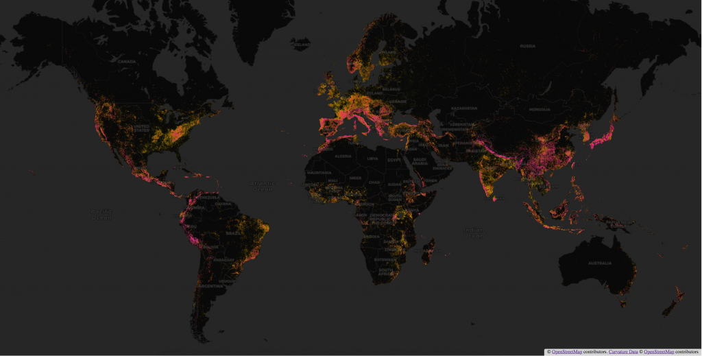
Curvature is a program that analyzes the geometry of OSM roads and generates a map of the most twisty roads, color-coded by how many curves they have. I use it to identify fun roads for motorcycle touring.

צפייה ברשומה המלאה

מיקום: Middlebury Village Historic District, Middlebury, Addison County, Vermont, 05753, United States

Video: Debugging multipolygons in JOSM

פורסם על־ידי Adam Franco ב־16 באוקטובר 2019 בEnglish.

https://youtu.be/87nRQHuatOE

A short tutorial of identifying and fixing errors in multipolygons when editing Open Street Map in the JOSM editor.

See also my previous video on creating and editing multipolygons in JOSM: https://youtu.be/x7SPb0JtheA

The tools used are:

Documentation on MultiPolygons in the OSM wiki:

מיקום: Goshen, Addison County, Vermont, United States

Video: Mapping OSM landcover multipolygons with JOSM

פורסם על־ידי Adam Franco ב־16 באוקטובר 2019 בEnglish.

https://youtu.be/x7SPb0JtheA

This is a brief overview of how I edit Open Street Map (OSM) to add adjoining land-cover areas as multipolygons with shared boundary ways to reduce duplication and overlapping ways.

The area I’m editing, is replete with examples of this type of mapping: osm.org/#map=14/44.0199/-73.1530

The tools used are:

Documentation on MultiPolygons in the OSM wiki:

I also have a video about debugging gaps in multipolygons: https://youtu.be/87nRQHuatOE

מיקום: Buttolph Acres, Middlebury, Addison County, Vermont, 05753, United States

Street orientations in Vermont

פורסם על־ידי Adam Franco ב־21 בספטמבר 2018 בEnglish.

By now many folks have seen Geoff Boeing’s really neat charts of street orientation that highlight how “gridded” (or not) the layout of city streets are:

Since Geoff was kind enough to provide a full open-source tool-chain, I decided to tweak it to chart the orientations of the streets of some cities and villages in my home state of Vermont:

Street orientations of Vermont

Unfortunately, until I get around to importing Vermont town boundaries, not all towns will be super easy to include in this analysis.

מיקום: Middlebury Village Historic District, Middlebury, Addison County, Vermont, 05753, United States